
Bridgeport is a city in eastern Harrison County, West Virginia, United States. The population was 9,325 at the 2020 census. It is part of the Clarksburg micropolitan area in North Central West Virginia. Bridgeport had its beginning in pre-American Revolutionary War times. In 1764, John Simpson entered the area and gave his name to Simpson Creek. Bridgeport was chartered in 1816.

The Battle of Resaca de la Palma was one of the early engagements of the Mexican–American War, where the United States Army under General Zachary Taylor engaged the retreating forces of the Mexican Ejército del Norte under General Mariano Arista on May 9, 1846. The United States emerged victorious and forced the Mexicans out of Texas.

Vementry is an uninhabited Scottish island in Shetland on the north side of the West Mainland, lying south of Muckle Roe.

"Karl-Gerät" (040/041), also known as Mörser Karl, was a World War II German self-propelled siege mortar (Mörser) designed and built by Rheinmetall. Its heaviest munition was a 60 cm (24 in) diameter, 2,170 kg (4,780 lb) shell, and the range for its lightest shell of 1,250 kg (2,760 lb) was just over 10 km (6.2 mi). Each gun had to be accompanied by a crane, a two-piece heavy transport set of railcars, and several modified tanks to carry shells.

Fort Ward Park is park located along Rich Passage on the southern end of Bainbridge Island in Washington. Fort Ward Park is part of the Bainbridge Island Metro Park and Recreation District, on land which the former military base, Fort Ward, was located. It was a state park from 1960 to 2011 but is now locally managed.
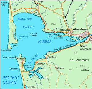
Grays Harbor is an estuarine bay located 45 miles (72 km) north of the mouth of the Columbia River, on the southwest Pacific coast of Washington state, in the United States. It is a ria, which formed at the end of the last ice age, when sea levels flooded the Chehalis River. The bay is 17 miles (27 km) long and 12 miles (19 km) wide. The Chehalis River flows into its eastern end, where the city of Aberdeen stands at that river's mouth, on its north bank, with the somewhat smaller city of Hoquiam immediately to its northwest, along the bayshore. Besides the Chehalis, many lesser rivers and streams flow into Grays Harbor, such as Hoquiam River and Humptulips River. A pair of low peninsulas separate it from the Pacific Ocean, except for an opening about two miles (3 km) in width. The northern peninsula, which is largely covered by the community of Ocean Shores, ends in Point Brown. Facing that across the bay-mouth is Point Chehalis, at the end of the southern peninsula upon which stands the town of Westport.

Drummond Battery, also known as Fort Drummond, is a heritage-listed former coastal artillery fortification and now television station and mushroom farm at 1 Television Avenue, Mt Drummond, Mount Saint Thomas, City of Wollongong, New South Wales, Australia. It was built between 1942 and 1943 by the NSW Public Works Department and NSW Department of Main Roads. The Australian Army used the site from 1942.
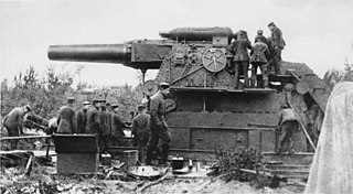
The 42 cm kurze Marinekanone L/12, or Gamma-Gerät, was a German siege gun built by Krupp. The Gamma-Gerät's barrel diameter was 42 cm (17 in), making it one of the largest artillery pieces ever fielded. The Gamma-Gerät began development in 1906 and entered service with the Imperial German Army in 1911. The Gamma-Gerät was the most powerful piece of artillery fielded by the Imperial German Army, but due to its extreme weight was mostly immobile and could only be emplaced near permanent rail lines. As a result, the Gamma-Gerät had limited effectiveness on the Western and Eastern Fronts of World War I.

The Civil War Defenses of Washington were a group of Union Army fortifications that protected the federal capital city, Washington, D.C., from invasion by the Confederate States Army during the American Civil War.

The Krepost Sveaborg was an Imperial Russian system of land and coastal fortifications constructed around Helsinki during the First World War. The purpose of the fortress was to provide a secure naval base for the Russian Baltic fleet and to protect Helsinki and block routes to Saint Petersburg from a possible German invasion. Krepost Sveaborg was part of Peter the Great's Naval Fortress, a coastal fortification system protecting access to Saint Petersburg by sea. The central part of Krepost Sveaborg was the old fortress of Suomenlinna where the fortress headquarters were located. Due to technological advances in artillery the old fortress was no longer capable of providing a sufficient protection, and a new main defensive line was built well beyond the old fortress boundaries. New coastal artillery guns built on outlying islands protected Krepost Sveaborg from the sea, while fortified lines constructed around Helsinki were intended to stop any attacks on land. The primary coastal guns were 10 in (254 mm) model 1891 guns and 6 in (152 mm) model 1892 Canet guns. Older 11 in (279 mm) model 1877 guns were also used. In summer 1917 the fortress had two hundred coastal or anti-landing guns, of which 24 were 10-inch guns in six batteries, 16 were 6-inch Canet guns in four batteries and twelve were 11-inch guns in three batteries. The artillery used in land fortifications included older coastal guns, old fixed carriage guns and newer light field guns. In March 1917, Krepost Sveaborg had a total of 463 guns, although many of them were obsolescent. Krepost Sveaborg was still partly incomplete in 1917 when the February Revolution halted most of the construction work. Some further construction work was carried out during the remaining year, but all work halted during the October Revolution. Following the Finnish Declaration of Independence, parts of the land fortifications were used in the Finnish Civil War. The coastal fortifications were later taken over by Finland to protect Helsinki, while the land fortifications were mostly abandoned and disarmed.

The Bombardment of Fort Stevens occurred in June 1942, in the American Theater and the Pacific Theater of World War II. The Imperial Japanese submarine I-25 fired on Fort Stevens, which defended the Oregon side of the Columbia River's Pacific entrance.

East Gate/West Gate, a public sculpture by Sasson Soffer, is located on the Indiana University-Purdue University Indianapolis campus, which is near downtown Indianapolis, Indiana. This sculpture is on loan from the Indianapolis Museum of Art and was installed on campus on March 22, 2009. It was transported from the Indianapolis Museum of Art to its current location, in front of University Library, from the Indianapolis Museum of Art via helicopter. East Gate/West Gate was constructed in 1973 and consists of stainless steel pipe. Its dimensions are 24'x 40'x 30' and weighs 840 lbs.

Fort Kamehameha was a United States Army military base that was the site of several coastal artillery batteries to defend Pearl Harbor starting in 1907 in Honolulu, Hawaii.

Fort de Villey-le-Sec, also known as Fort Trévise, is a fortification of the 19th century, built as part of the Séré de Rivières system of fortifications in Villey-le-Sec, France, one of the defenses of Toul. It is a unique example for its time of a defensive enclosure around a village. Conceived after the defeat of the Franco-Prussian War of 1870-71, the fort was located away from the main combat zone of World War I and has remained almost intact. The fort's preservation association has been at work since 1961 to restore and interpret the site. It has been included in the Inventory of Historic Sites and has been designated as a preserved natural area.

Fort Andrews was created in 1897 as part of the Coast Defenses of Boston, Massachusetts. Construction began in 1898 and the fort was substantially complete by 1904. The fort was named after Major General George Leonard Andrews, an engineer and Civil War commander, who assisted in the construction of nearby Fort Warren in Boston Harbor. It occupies the entire northeast end of Peddocks Island in Boston Harbor, and was originally called the Peddocks Island Military Reservation. Once an active Coast Artillery post, it was manned by hundreds of soldiers and bristled with mortars and guns that controlled the southern approaches to Boston and Quincy Bay. The fort also served as a prisoner-of-war camp for Italian prisoners during World War II, who were employed as laborers following the Italian surrender to the Allies in 1943. Today, the fort is abandoned, and is managed by the Massachusetts Department of Conservation and Recreation, as part of the Boston Harbor Islands National Recreation Area.

Jewell Island is a small island in Casco Bay, Maine, United States. About 1 mile (1.6 km) long from SW to NE, it is located off the coast of Cliff Island, approximately 8 miles from downtown Portland, Maine. It is a state-owned island with a small but protected harbor as well as camping and walking paths. Jewell Island was part of the Harbor Defenses of Portland fort network. The island is part of the city of Portland. Jewell Island can be reached by private or charter boats. There is no ferry service to the island.
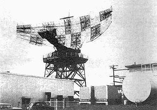
The AN/FPS-24 Radar was a long range early warning radar used by the United States Air Force Air Defense Command. It used a two-frequency signal in order to avoid fluctuation loss, which causes signals on single-frequency radars to fade in and out as the target moves. Reducing this effect results in a much steadier signal.

Cape Charles Air Force Station is a closed United States Air Force General Surveillance Radar station. It is located 3.6 miles (5.8 km) south of Townsend, Virginia. It was closed in 1981. From 1941 to 1948 it was Fort John Custis of the United States Army Coast Artillery Corps. Since 1984 the site has been in the Eastern Shore of Virginia National Wildlife Refuge. For this article's purposes the term "Fort John Custis" includes the nearby Fisherman Island.
Uptown Triangles is a public artwork by artist John Adduci, located on the corner of N. 48th St. and W. Lisbon Ave. which is in Milwaukee, Wisconsin, USA. The work is a monumental sculpture in the form of intersecting triangles made of aluminum. It is 20 feet tall, 12 feet in width and 10 feet in depth and sits on a concrete foundation. The piece was created in 2009 and is owned by the Uptown Crossing Business Improvement District BID 16.
