The Isle of Man had become physically separated from Great Britain and Ireland by 6500 BC. It appears that colonisation took place by sea sometime during the Mesolithic era. The island has been visited by various raiders and trading peoples over the years. After being settled by people from Ireland in the first millennium AD, the Isle of Man was converted to Christianity and then suffered raids by Vikings from Norway. After becoming subject to Norwegian suzerainty as part of the Kingdom of Mann and the Isles, the Isle of Man later became a possession of the Scottish and then the English crowns.

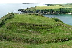
Langness is a peninsula which protrudes two kilometres at the southern extremity of the Isle of Man. Signifying a cape or extended promontory, Langness literally means "long promontory" in Old Norse. Formerly an island, Langness was eventually joined to the mainland by the movement and deposition of material along Castletown Bay to form a tombolo. The small community of Derbyhaven is situated on the east coast of this isthmus, which lies close to Castletown, Isle of Man.

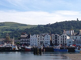
Peel is a seaside town and small fishing port in the Isle of Man, in the historic parish of German but administered separately. Peel is the third largest town in the island after Douglas and Ramsey but the fourth largest settlement, as Onchan has the second largest population but is classified as a village. Until 2016 Peel was also a House of Keys constituency, electing one Member of the House of Keys (MHK), who, from September 2015, was Ray Harmer. Peel has a ruined castle on St Patrick's Isle, and a cathedral, seat of the Diocese of Sodor and Man.
Ramsey is a coastal town in the north of the Isle of Man. It is the second largest town on the island after Douglas. Its population is 7,845 according to the 2016 Census. It has one of the biggest harbours on the island, and has a prominent derelict pier, called the Queen's Pier. It was formerly one of the main points of communication with Scotland. Ramsey has also been a route for several invasions by the Vikings and Scots.

A promontory fort is a defensive structure located above a steep cliff, often only connected to the mainland by a small neck of land, thus using the topography to reduce the ramparts needed. Although their dating is problematic, most seem to date to the Iron Age. They are mainly found in Brittany, Ireland, the Orkney Islands, the Isle of Man, Devon, the Channel Islands and Cornwall.

Carl Wark is a rocky promontory on Hathersage Moor in the Peak District National Park, just inside the boundary of Sheffield, England. The promontory is faced by vertical cliffs on all but one side, which is protected by a prehistoric embankment. The cliffs and embankment form an enclosure that has been interpreted as an Iron Age hill fort, though the date of construction and purpose of the fortifications remains unknown. The site is a scheduled monument.

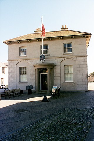
Manx National Heritage is the national heritage organisation for the Isle of Man. The organisation manages a significant proportion of the island’s physical heritage assets including over 3,000 acres of coastline and landscape. It holds property, archives, artwork, library and museum collections in trust for the Manx nation. It is the Isle of Man's statutory heritage agency and an Isle of Man registered charity (№ 603).

The Manx are a minority ethnic group originating on the Isle of Man, in the Irish Sea in Northern Europe. They belong to the diaspora of the Gaelic ethnolinguistic group, which now populate the parts of the British Isles and Ireland which once were the Kingdom of the Isles and Dál Riata. A recent genetical analysis of traditional Manx surnames, identified that the majority of the native manx population belong to the Haplogroup R-DF13 group. The native culture of the Isle of Man is described as Celtic with significant Gaelic, Norse, Norse-Gaelic, and minor northern English influences. The Manx are governed by themselves through Tynwald, the legislature of the island, which was introduced by Viking settlers over a thousand years ago. The native mythology and folklores of the Manx belong to the overall Celtic Mythology group, with Manannán mac Lir, the Mooinjer veggey, Buggane, Lhiannan-Shee, Ben-Varrey and the Moddey Dhoo being prominent mythological figures on the island. Their language, Manx Gaelic is derived from Middle Irish, which was introduced by settlers that colonised the island from Gaelic Ireland. However, Manx gaelic later developed in isolation and belongs as a separate Goidelic language of the Insular Celtic languages.

Manx English, or Anglo-Manx, is the historic dialect of English spoken on the Isle of Man, though today in decline. It has many borrowings from Manx, a Goidelic language, and it differs widely from any other variety of English, including dialects from other areas in which Celtic languages are or were spoken, such as Welsh English and Hiberno-English.
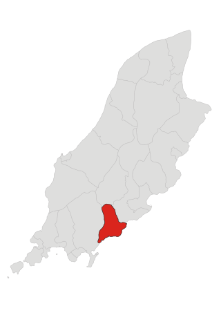
Santon, historically Santan, is one of the seventeen historic parishes of the Isle of Man.

Mount Murray is a hill 222 metres (728 ft) above sea level on the Isle of Man located at the northern end of Santon, near the boundaries with Marown and Braddan parishes. It is named after Lord Henry Murray, 4th Lieutenant Governor of the Isle of Man. Often referred to simply as The Mount and formerly as Cronk Glass(green hill), Mount Murray is home to the Chibbanagh Plantation and nine of the eighteen holes of the Mount Murray Golf Club.

Port Grenaugh is a cove in the south-east of the Isle of Man at the foot of Glen Grenaugh, in the parish of Santon, and the mouth of Grace's stream which originates in the Newtown area of the parish by Ballakissack farm.

Sulby is a village in the Isle of Man. It is 4 miles from Ramsey and is located in the parish of Kirk Christ Lezayre on the A3 Castletown road.
Laurel Bank is situated between the 10th Milestone and 11th Milestone road-side markers on the primary A3 Castletown to Ramsey Road between Ballacraine and Glen Helen in the parish of Kirk German in the Isle of Man.
Cronk ny Arrey Laa is a hill in the south west of the Isle of Man. It may be confused with a hill of a similar name in the parish of Jurby, further north along the west coast of the island.

Cronk-ny-Mona is situated between the 36 and 37 mile markers used for the Snaefell Mountain Course, being on the primary A18 Mountain Road at the road junction with the A21 Johnny Watterson('s) Lane and the tertiary C10 Scholag Road in the Isle of Man parish of Onchan.
Cronk Urleigh is a stretch of road situated at the 15th Milestone on the primary A3 Castletown to Ramsey in the parish of Kirk Michael in the Isle of Man.

Cornish promontory forts, commonly known in Cornwall as cliff castles, are coastal equivalents of the hill forts and Cornish "rounds" found on Cornish hilltops and slopes. Similar coastal forts are found on the north–west European seaboard, in Normandy, Brittany and around the coastlines of the British Isles, especially in Wales, Scotland and Ireland. Many are known in southwest England, particularly in Cornwall and its neighbouring county, Devon. Two have been identified immediately west of Cornwall, in the Isles of Scilly.