Geology is a branch of natural science concerned with the Earth and other astronomical objects, the rocks of which they are composed, and the processes by which they change over time. Modern geology significantly overlaps all other Earth sciences, including hydrology. It is integrated with Earth system science and planetary science.

An unconformity is a buried erosional or non-depositional surface separating two rock masses or strata of different ages, indicating that sediment deposition was not continuous. In general, the older layer was exposed to erosion for an interval of time before deposition of the younger layer, but the term is used to describe any break in the sedimentary geologic record. The significance of angular unconformity was shown by James Hutton, who found examples of Hutton's Unconformity at Jedburgh in 1787 and at Siccar Point in Berwickshire in 1788, both in Scotland.

The law of superposition is an axiom that forms one of the bases of the sciences of geology, archaeology, and other fields pertaining to geological stratigraphy. In its plainest form, it states that in undeformed stratigraphic sequences, the oldest strata will lie at the bottom of the sequence, while newer material stacks upon the surface to form new deposits over time. This is paramount to stratigraphic dating, which requires a set of assumptions, including that the law of superposition holds true and that an object cannot be older than the materials of which it is composed. To illustrate the practical applications of superposition in scientific inquiry, sedimentary rock that has not been deformed by more than 90° will exhibit the oldest layers on the bottom, thus enabling paleontologists and paleobotanists to identify the relative ages of any fossils found within the strata, with the remains of the most archaic lifeforms confined to the lowest. These findings can inform the community on the fossil record covering the relevant strata, to determine which species coexisted temporally and which species existed successively in perhaps an evolutionarily or phylogenetically relevant way.
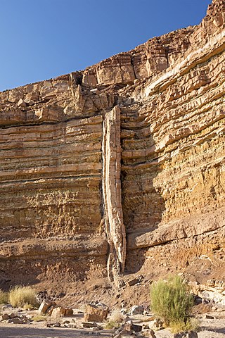
In geology, a dike or dyke is a sheet of rock that is formed in a fracture of a pre-existing rock body. Dikes can be either magmatic or sedimentary in origin. Magmatic dikes form when magma flows into a crack then solidifies as a sheet intrusion, either cutting across layers of rock or through a contiguous mass of rock. Clastic dikes are formed when sediment fills a pre-existing crack.

In geology, a sill is a tabular sheet intrusion that has intruded between older layers of sedimentary rock, beds of volcanic lava or tuff, or along the direction of foliation in metamorphic rock. A sill is a concordant intrusive sheet, meaning that it does not cut across preexisting rock beds. Stacking of sills builds a sill complex and a large magma chamber at high magma flux. In contrast, a dike is a discordant intrusive sheet, which does cut across older rocks. Sills are fed by dikes, except in unusual locations where they form in nearly vertical beds attached directly to a magma source. The rocks must be brittle and fracture to create the planes along which the magma intrudes the parent rock bodies, whether this occurs along preexisting planes between sedimentary or volcanic beds or weakened planes related to foliation in metamorphic rock. These planes or weakened areas allow the intrusion of a thin sheet-like body of magma paralleling the existing bedding planes, concordant fracture zone, or foliations.

The Moine Thrust Belt or Moine Thrust Zone is a linear tectonic feature in the Scottish Highlands which runs from Loch Eriboll on the north coast 190 kilometres (120 mi) south-west to the Sleat peninsula on the Isle of Skye. The thrust belt consists of a series of thrust faults that branch off the Moine Thrust itself. Topographically, the belt marks a change from rugged, terraced mountains with steep sides sculptured from weathered igneous, sedimentary and metamorphic rocks in the west to an extensive landscape of rolling hills over a metamorphic rock base to the east. Mountains within the belt display complexly folded and faulted layers and the width of the main part of the zone varies up to 10 kilometres (6.2 mi), although it is significantly wider on Skye.

Lithostratigraphy is a sub-discipline of stratigraphy, the geological science associated with the study of strata or rock layers. Major focuses include geochronology, comparative geology, and petrology.
Relative dating is the science of determining the relative order of past events, without necessarily determining their absolute age. In geology, rock or superficial deposits, fossils and lithologies can be used to correlate one stratigraphic column with another. Prior to the discovery of radiometric dating in the early 20th century, which provided a means of absolute dating, archaeologists and geologists used relative dating to determine ages of materials. Though relative dating can only determine the sequential order in which a series of events occurred, not when they occurred, it remains a useful technique. Relative dating by biostratigraphy is the preferred method in paleontology and is, in some respects, more accurate. The Law of Superposition, which states that older layers will be deeper in a site than more recent layers, was the summary outcome of 'relative dating' as observed in geology from the 17th century to the early 20th century.

The Narryer Gneiss Terrane is a geological complex in Western Australia that is composed of a tectonically interleaved and polydeformed mixture of granite, mafic intrusions and metasedimentary rocks in excess of 3.3 billion years old, with the majority of the Narryer Gneiss Terrane in excess of 3.6 billion years old. The rocks have experienced multiple metamorphic events at amphibolite or granulite conditions, resulting in often complete destruction of original igneous or sedimentary (protolith) textures. Importantly, it contains the oldest known samples of the Earth's crust: samples of zircon from the Jack Hills portion of the Narryer Gneiss have been radiometrically dated at 4.4 billion years old, although the majority of zircon crystals are about 3.6-3.8 billion years old.

The Carrizo Mountains is a small, mostly circular mountain range 15 to 20 km in diameter located on the Colorado Plateau in northeastern Arizona. The range is about 20 km (12 mi) southwest of the Four Corners. The highest summit, Pastora Peak, is 2,869 m (9,413 ft) in elevation, whereas elevations on the surrounding plateau are near 1,800 m (5,900 ft).

In geology, an igneous intrusion is a body of intrusive igneous rock that forms by crystallization of magma slowly cooling below the surface of the Earth. Intrusions have a wide variety of forms and compositions, illustrated by examples like the Palisades Sill of New York and New Jersey; the Henry Mountains of Utah; the Bushveld Igneous Complex of South Africa; Shiprock in New Mexico; the Ardnamurchan intrusion in Scotland; and the Sierra Nevada Batholith of California.

Earth Revealed: Introductory Geology, originally titled Earth Revealed, is a 26-part video instructional series covering the processes and properties of the physical Earth, with particular attention given to the scientific theories underlying geological principles. The telecourse was produced by Intelecom and the Southern California Consortium, was funded by the Annenberg/CPB Project, and first aired on PBS in 1992 with the title Earth Revealed. All 26 episodes are hosted by Dr. James L. Sadd, professor of environmental science at Occidental College in Los Angeles, California.
A tectonic phase or deformation phase is in structural geology and petrology a phase in which tectonic movement or metamorphism took place. Tectonic phases can be extensional or compressional in nature.
A stratigraphic column is a representation used in geology and its subfield of stratigraphy to describe the vertical location of rock units in a particular area. A typical stratigraphic column shows a sequence of sedimentary rocks, with the oldest rocks on the bottom and the youngest on top.
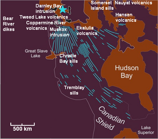
The Mackenzie Large Igneous Province (MLIP) is a major Mesoproterozoic large igneous province of the southwestern, western and northwestern Canadian Shield in Canada. It consists of a group of related igneous rocks that were formed during a massive igneous event starting about 1,270 million years ago. The large igneous province extends from the Arctic in Nunavut to near the Great Lakes in Northwestern Ontario where it meets with the smaller Matachewan dike swarm. Included in the Mackenzie Large Igneous Province are the large Muskox layered intrusion, the Coppermine River flood basalt sequence and the massive northwesterly trending Mackenzie dike swarm.

A sheet intrusion, or tabular intrusion, is a planar sheet of roughly the same thickness, that forms inside a pre-existing rock. When it cuts into another unlayered mass, or across layers, it is called a dike. When it is formed between layers in a layered rock mass, it is called a sill.

The Lewisian complex or Lewisian gneiss is a suite of Precambrian metamorphic rocks that outcrop in the northwestern part of Scotland, forming part of the Hebridean Terrane and the North Atlantic Craton. These rocks are of Archaean and Paleoproterozoic age, ranging from 3.0–1.7 billion years (Ga). They form the basement on which the Torridonian and Moine Supergroup sediments were deposited. The Lewisian consists mainly of granitic gneisses with a minor amount of supracrustal rocks. Rocks of the Lewisian complex were caught up in the Caledonian orogeny, appearing in the hanging walls of many of the thrust faults formed during the late stages of this tectonic event.

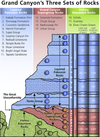
The Unkar Group is a sequence of strata of Proterozoic age that are subdivided into five geologic formations and exposed within the Grand Canyon, Arizona, Southwestern United States. The 5-unit Unkar Group is the basal member of the 8-member Grand Canyon Supergroup. The Unkar is about 1,600 to 2,200 m thick and composed, in ascending order, of the Bass Formation, Hakatai Shale, Shinumo Quartzite, Dox Formation, and Cardenas Basalt. Units 4 & 5 are found mostly in the eastern region of Grand Canyon. Units 1 through 3 are found in central Grand Canyon. The Unkar Group accumulated approximately between 1250 and 1104 Ma. In ascending order, the Unkar Group is overlain by the Nankoweap Formation, about 113 to 150 m thick; the Chuar Group, about 1,900 m (6,200 ft) thick; and the Sixtymile Formation, about 60 m (200 ft) thick. These are all of the units of the Grand Canyon Supergroup. The Unkar Group makes up approximately half of the thickness of the 8-unit Supergroup.

The Southern Oklahoma Aulacogen is a failed rift, or failed rift arm (aulacogen), of the triple junction that became the Iapetus Ocean spreading ridges. It is a significant geological feature in the Western and Southern United States. It formed sometime in the early to mid Cambrian Period and spans the Wichita Mountains, Taovayan Valley, Anadarko Basin, and Hardeman Basin in Southwestern Oklahoma. The Southern Oklahoma Aulacogen is primarily composed of basaltic dikes, gabbros, and units of granitic rock.
A geological contact is a boundary which separates one rock body from another. A contact can be formed during deposition, by the intrusion of magma, or through faulting or other deformation of rock beds that brings distinct rock bodies into contact.


