Related Research Articles

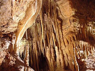
A stalactite (, ; from the Greek 'stalaktos' via stalassein is a mineral formation that hangs from the ceiling of caves, hot springs, or man-made structures such as bridges and mines. Any material that is soluble and that can be deposited as a colloid, or is in suspension, or is capable of being melted, may form a stalactite. Stalactites may be composed of lava, minerals, mud, peat, pitch, sand, sinter, and amberat. A stalactite is not necessarily a speleothem, though speleothems are the most common form of stalactite because of the abundance of limestone caves.
A stalagmite is a type of rock formation that rises from the floor of a cave due to the accumulation of material deposited on the floor from ceiling drippings. Stalagmites are typically composed of calcium carbonate, but may consist of lava, mud, peat, pitch, sand, sinter, and amberat.
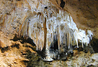
A speleothem is a geological formation by mineral deposits that accumulate over time in natural caves. Speleothems most commonly form in calcareous caves due to carbonate dissolution reactions. They can take a variety of forms, depending on their depositional history and environment. Their chemical composition, gradual growth, and preservation in caves make them useful paleoclimatic proxies.
The Highland Rim is a geographic term for the area in Tennessee surrounding the Central Basin. Nashville is largely surrounded by higher terrain in all directions.

Luray Caverns, originally called Luray Cave, is a cave just west of Luray, Virginia, United States, which has drawn many visitors since its discovery in 1878. The cavern system is generously adorned with speleothems such as columns, mud flows, stalactites, stalagmites, flowstone, and mirrored pools. The caverns are perhaps best known for the Great Stalacpipe Organ, a lithophone made from solenoid-fired strikers that tap stalactites of various sizes to produce tones similar to those of xylophones, tuning forks, or bells.
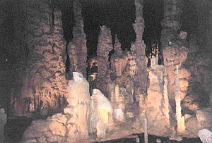
Cathedral Caverns State Park is a publicly owned recreation area and natural history preserve located in Kennamer Cove, Alabama, approximately 5 miles (8.0 km) northeast of Grant and 7 miles (11 km) southeast of Woodville in Marshall County. The park's main feature, first known as Bats Cave, was developed as a tourist attraction in the 1950s. Cathedral Caverns was declared a National Natural Landmark in 1972 and opened as a state park in 2000.

Treak Cliff Cavern is a show cave near Castleton in Derbyshire, England. It is part of the Castleton Site of Special Scientific Interest and one of only two sites where the ornamental mineral Blue John is still excavated. As part of an agreement with English Nature, the Blue John that can be seen in the show cave is not mined but it is extracted in small quantities from other areas of the cave and made into saleable items like bowls, jewellery and ornaments.

The Delaware Basin is a geologic depositional and structural basin in West Texas and southern New Mexico, famous for holding large oil fields and for a fossilized reef exposed at the surface. Guadalupe Mountains National Park and Carlsbad Caverns National Park protect part of the basin. It is part of the larger Permian Basin, itself contained within the Mid-Continent oil province.
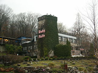
Ruby Falls is a series of underground cascading waterfalls totaling 145 feet (44 m) in Lookout Mountain, near Chattanooga, Tennessee, in the United States.

Jacobs Cavern is a cave or rock shelter east of Pineville in McDonald County, Missouri.

Illinois Caverns is a state natural area in the New Design Precinct of Monroe County, Illinois. It features Illinois Caverns which is alternatively known as Mammoth Cave of Illinois. Illinois Caverns is the second-largest cave in Illinois and has more than 9.6 km of passages. The cave has a constant temperature of 58 °F (14 °C), and portions flood during wet weather. Passages can be 20 feet (6.1 m) high and just as wide. It is located off Illinois Route 3, south of Waterloo, near the unincorporated community of Burksville.

Poole's Cavern or Poole's Hole is a two-million-year-old natural limestone cave on the edge of Buxton in the Peak District, in the county of Derbyshire, England.
Carlsbad Caverns National Park is an American national park in the Guadalupe Mountains of southeastern New Mexico. The primary attraction of the park is the show cave Carlsbad Cavern. Visitors to the cave can hike in on their own via the natural entrance or take an elevator from the visitor center.

Grand Caverns, formerly known as Weyer's Cave, is located in the central Shenandoah Valley in the town of Grottoes, Virginia, United States. A limestone cavern, it claims the distinction of being America's oldest show cave, in operation since 1806.
Crystal Grottoes is the only show cave in the U.S. state of Maryland. It is located on Maryland Route 34 between Boonsboro and Antietam National Battlefield.

A solutional cave, solution cave, or karst cave is a cave usually formed in the soluble rock limestone. It is the most frequently occurring type of cave. It can also form in other rocks, including chalk, dolomite, marble, salt beds, and gypsum.
Bluff Dweller's Cave is a show cave located just south of Noel, Missouri that was discovered in 1925 and opened to the public in 1927. The cave was formed in the Pierson Limestone during the Paleozoic Era. The cave's passages total over 4,000 ft in length, with two entrances beneath a limestone outcropping of the bluff.
Euhadenoecus is a genus of camel crickets in the family Rhaphidophoridae. There are at least four described species in Euhadenoecus.

The Derbyshire Dome is a geological formation across mid-Derbyshire in England.
References
- 1 2 Project, Federal Writers' (1941). The WPA Guide to Alabama: The Camellia State (2013 ed.). Trinity University Press. ISBN 9781595342010 . Retrieved 2 January 2018.
- 1 2 3 Kazek, Kelly (29 March 2016). "You can own this cave in Alabama". al.com . Retrieved 2 January 2018.[ better source needed ]
- ↑ US Steel Corp. No.8 Blast Furnace Permit: Environmental Impact Statement (Report). Vol. 1. 1978. p. 164. Retrieved 2 January 2018.
- 1 2 Tidmore, Tina. "Let me Introduce you to the City of Clay". Clay-Pinson Chamber of Commerce. Archived from the original on 14 August 2015. Retrieved 2 January 2018.
- 1 2 3 Matthews, Larry (July–September 1989). "Cave trips from Edward McCrady's journals" (PDF). The Journal of Spelean History. 23 (3): 59. Archived from the original (PDF) on 2 January 2018. Retrieved 2 January 2018.
- 1 2 Congressional Record: Proceedings and Debates of the ... Congress. U.S. Government Printing Office. 1966. p. 21170. Retrieved 2 January 2018.
- ↑ "First Post Office and Nature Tourism". City of Clay AL. Retrieved 2 January 2018.
- ↑ Krupka, Robert A. (June 11, 1965). An Evaluation of the Shelter Potential in Mines, Caves and Tunnels Appendices I, II, III (Report). Retrieved 2 January 2018.[ dead link ]
- 1 2 3 4 5 6 Johnston, William Drumm (1933). "17. The Alabama Caverns". Ground Water in the Paleozoic Rocks of Northern Alabama (16, Part 2): 67–8. Retrieved 2 January 2018.
The Alabama Caverns, formerly known as McClunney Cave, are situated on the south end of Meridian Mountain, in sec. 13, T. 15 S., R. 1 W., Jefferson County, near the village of Clay, about 18 miles northeast of Birmingham. Dr. R. S. Poor, of Birmingham Southern College, has kindly furnished the writer with notes and a cross section of this cave, from which Figure 36 and the following description are taken. The cave is in the Chickamauga limestone, about 100 feet above the Copper Ridge dolomite. It has the form of a high and narrow passage trending N. 55° E., parallel with the strike of the beds, for a total distance of 800 feet from the entrance. Although the main trend of the cave is parallel with the strike, at a number of places it turns at right angles and follows the dip (22° NW.) for short distances. In addition to two sets of fractures paralleling the dip and the strike of the rocks, there is a marked joint system striking almost due north, which the cave follows in four short stretches. The cave shows a number of depositional features. Stalactites, stalagmites, and onyx crusts and rosettes are present. "Capitol Dome" is a stalagmitic deposit upon one wall which has the form of the dome of the Capitol at Washington, and the "Family Loft" is a recess near the ceiling which contains two large columns and several small stalagmites. The maximum vertical height of the cave, measured between the bottom of the pit in which the "spring" is located and the dome above, is 67 feet. Although the spring has a slight drip during wet seasons, it lies above the main regional water table throughout the year.
- 1 2 3 Ayrs, Emma A. (1933). "The Geology of Alabama Caverns". The Journal of the Alabama Academy of Science. 4: 32. Retrieved 2 January 2018.
Detailed measurements of strike and dip along outcrops and exposures within the cave called Alabama Caverns, near Clay, Alabama, coupled with an accurate plane-table survey within the cave showed conclusively that this cavern developed along a strike joint, i.e., parallel to the outcropping edge of the Chickamauga dolomitic limestone in which it is located. The cavern is about one-half mile long and very sinuous. Its greatest height within is about 80 feet. Undoubtedly the groundwater solution producing it occurred along a strike joint. The latter was produced when the Appalachian Mountains were folded at the close of the Paleozoic era. There is some evidence to show that at least a part of the solution occurred below the ground-water table, but most of it probably occurred above this level by vadose water after folding. The ground-water level is now about 20 feet below the lowest traveled portion of the cavern.
- ↑ Stringfield, V.T. (1966). "Artesian Water in Tertiary Limestone in the Southeastern States". Geophysical Field Investigations, 1964–67. Geological Survey Professional Paper. United States Printing Office. p. 133. Retrieved 2 January 2017.
- ↑ "pecki | Field Guide and Catalogues". museum.wa.gov.au. Archived from the original on 20 April 2019. Retrieved 2 January 2018.
- ↑ "Glyphyalinia pecki Hubricht 1966". Bulletin - Alabama Museum of Natural History. University of Alabama. 1975. Retrieved 2 January 2018.
- ↑ "Species Euhadenoecus insolitus - McCluney Cave Cricket - BugGuide.Net". bugguide.net. Retrieved 2 January 2018.
- ↑ Hubbell, Theodore H.; Norton, Russell M. (August 1, 1978). "The Systematics and Biology of the Cave-Crickets of the North American Tribe Hadenoecini (Orthoptera Saltatoria:Ensifera: Rhaphidophoridae: Dolichopodinae)" (PDF). Miscellaneous Publications. Museum of Zoology. University of Michigan (156): 45–47. Retrieved 2 January 2018.