
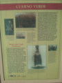
Cuerno Verde (died September 3, 1779) is the Spanish name for Tavibo Naritgant, a leader of the Comanche, likely of the Kotsoteka Comanche, in the late 18th century.
Cuerno Verde (died September 3, 1779) is the Spanish name for Tavibo Naritgant, a leader of the Comanche, likely of the Kotsoteka Comanche, in the late 18th century.
Cuerno Verde ("Green Horn" in English), is the Spanish name given to Tavibo Naritgant ("Dangerous Man") because of the green tinted horn(s) that he wore on his head-dress in battle. The English translation of the Comanche name is "Dangerous Man." [1] His son inherited both the name and the distinctive head dress from the father, who was killed in combat against the Spanish at Ojo Caliente, in what is now New Mexico, in October 1768. [2]
As a young man, Tabivo Naritgant led a series of successful raids into Nuevo Mexico during the mid- to late 1770s. The Spanish Viceroy in New Spain noticed this threat to them, and offered Juan Bautista de Anza the governorship of Nuevo Mexico with instructions to deal with the various local Indians, including Tavibo Naritgant. De Anza moved to Nuevo Mexico and assumed the Governorship and for a year, studied past expeditions against and encounters with Cuerno Verde. A year later, in August 1779, de Anza led a mixed force of 500 to 800 Spanish troops and Ute, Apache, and Pueblo auxiliaries on a punitive expedition against the Comanche. [3] [4]
The Comanche and Spanish forces met in a series of running battles between August 31 and September 3, 1779; Tabivo Naritgant was killed in combat, along with his first-born son and fifteen others, on September 3 somewhere between the present day cities of Pueblo, Colorado and Colorado City, Colorado, probably in a gully of the St. Charles River. Hostilities in the area decreased following his death. [5]
The "green horn" head-dress of Cuerno Verde was taken from the battlefield and presented to the Viceroy by de Anza. It has been reported that the Viceroy presented the headdress to the King of Spain, who in turn presented the headdress to the Pope. [6]
Anza called him a "cruel scourge" and made note in his diaries of atrocities attributed to him. Some modern Comanches question the veracity of Anza's statements while maintaining that Tabivo Naritgant'a warring activities were appropriate for a Comanche leader of the period. [7]
Greenhorn Mountain and the Greenhorn Valley in south-central Colorado are named after the English translation of his Spanish name. [1]

Juan Bautista de Anza Bezerra Nieto was an expeditionary leader, military officer, and politician primarily in California and New Mexico under the Spanish Empire. He is credited as one of the founding fathers of Spanish California and served as an official within New Spain as Governor of the province of New Mexico.

Santa Fe de Nuevo México was a province of the Spanish Empire and New Spain, and later a territory of independent Mexico. The first capital was San Juan de los Caballeros from 1598 until 1610, and from 1610 onward the capital was La Villa Real de la Santa Fe de San Francisco de Asís.
The Quechan, or Yuma, are a Native American tribe who live on the Fort Yuma Indian Reservation on the lower Colorado River in Arizona and California just north of the Mexican border. Despite their name, they are not related to the Quechua people of the Andes. Members are enrolled into the Quechan Tribe of the Fort Yuma Indian Reservation. The federally recognized Quechan tribe's main office is located in Winterhaven, California. Its operations and the majority of its reservation land are located in California, United States.

Colorado City is a census-designated place (CDP) and post office in and governed by Pueblo County, Colorado, United States. The CDP is a part of the Pueblo, CO Metropolitan Statistical Area. The Colorado City post office has the ZIP Code 81019. At the United States Census 2020, the population of the Colorado City CDP was 2,237. The Colorado City Metropolitan District provides services.

Francisco Hermenegildo Tomás GarcésO.F.M. was a Spanish Franciscan friar who served as a missionary and explorer in the colonial Viceroyalty of New Spain. He explored much of the southwestern region of North America, including present day Sonora and Baja California in Mexico, and the U.S. states of Arizona and California. He was killed along with his companion friars during an uprising by the Native American population, and they have been declared martyrs for the faith by the Catholic Church. The cause for his canonization was opened by the Church.

The Juan Bautista de Anza National Historic Trail is a 1,210-mile (1,950 km) trail extending from Nogales on the U.S.-Mexico border in Arizona, through the California desert and coastal areas in Southern California and the Central Coast region to San Francisco. The trail commemorates the 1775–1776 land route that Spanish commander Juan Bautista de Anza took from the Sonora y Sinaloa Province of New Spain in Colonial Mexico through to Las Californias Province. The goal of the trip was to establish a mission and presidio on the San Francisco Bay. The trail was an attempt to ease the course of Spanish colonization of California by establishing a major land route north for many to follow. It was used for about five years before being closed by the Quechan (Yuma) Indians in 1781 and kept closed for the next 40 years. It is a National Historic Trail administered by the National Park Service and was also designated a National Millennium Trail.
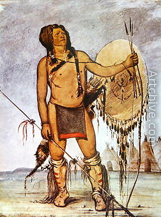
Comanche history In the 18th and 19th centuries the Comanche became the dominant tribe on the southern Great Plains. The Comanche are often characterized as "Lords of the Plains." They presided over a large area called Comancheria which they shared with allied tribes, the Kiowa, Kiowa-Apache, Wichita, and after 1840 the southern Cheyenne and Arapaho. Comanche power and their substantial wealth depended on horses, trading, and raiding. Adroit diplomacy was also a factor in maintaining their dominance and fending off enemies for more than a century. They subsisted on the bison herds of the Plains which they hunted for food and skins.
The Comancheros were a group of 18th- and 19th-century traders based in northern and central New Mexico. They made their living by trading with the nomadic Great Plains Indian tribes in northeastern New Mexico, West Texas, and other parts of the southern plains of North America. The name "Comancheros" comes from the Comanche tribe, in whose territory they traded. They traded manufactured goods, flour, tobacco, and bread for hides, livestock and slaves from the Comanche. As the Comancheros did not have regular access to weapons and gunpowder, there is disagreement about how much they traded these with the Comanche.

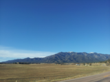
Greenhorn Mountain is the highest summit of the Wet Mountains range in the Rocky Mountains of North America. The prominent 12,352-foot (3,765 m) peak is located in the Greenhorn Mountain Wilderness of San Isabel National Forest, 5.2 miles (8.4 km) southwest by west of the Town of Rye, Colorado, United States, on the boundary between Huerfano and Pueblo counties. The summit of Greenhorn Mountain is the highest point in Pueblo County, Colorado. The peak's summit rises above timberline, which is about 11,500 feet (3,500 m) in south-central Colorado.

Felipe de Neve y Padilla was a Spanish soldier who served as the 4th Governor of the Californias, from 1775 to 1782. Neve is one of the founders of Los Angeles and was instrumental in the foundation of San Jose and Santa Barbara.
Arizpe is a small town and the municipal seat of the Arizpe Municipality in the north of the Mexican state of Sonora. It is located at 30°20'"N 110°09'"W. The area of the municipality is 2,806.78 sq.km. The population in 2005 was 2,959 of which 1,743 lived in the municipal seat as of the 2000 census.
José Joaquín de la Santísima Trinidad Moraga, usually simply known as José Joaquín Moraga, was a Spanish colonial expeditionary and soldier who founded San Jose, California, in 1777.
Antonio Valverde y Cosío was the architect behind the disastrous Villasur expedition wherein the famous Spanish colonial scout José Naranjo perished.

Tomás Vélez Cachupín was a colonial judge, and the Spanish colonial governor of Santa Fe de Nuevo México province, located in the northern Viceroyalty of New Spain, from 1749 to 1754 and 1762 to 1767. During his rule, Cachupín achieved the peace between Spaniards and the Amerindian peoples of New Mexico, especially the Comanches. He also protected the right to the possession of lands by the people of New Mexico, including the Amerindians, fining and imprisoning those who occupied the lands of others under the idea that these lands were property of their inhabitants.

The early history of the Arkansas Valley in Colorado began in the 1600s and to the early 1800s when explorers, hunters, trappers, and traders of European descent came to the region. Prior to that, Colorado was home to prehistoric people, including Paleo-Indians, Ancestral Puebloans, and Late prehistoric Native Americans.

The Hispanos of New Mexico, also known as Neomexicanos or Nuevomexicanos, are Hispanic residents originating in the historical region of Santa Fe de Nuevo México, today the US state of New Mexico, southern Colorado, and other parts of the Southwestern United States including Arizona, Nevada, Texas, and Utah. They are descended from Oasisamerica groups and the settlers of the Viceroyalty of New Spain, the First Mexican Empire and Republic, the Centralist Republic of Mexico, and the New Mexico Territory.

Bernardo de Miera y Pacheco was "perhaps the most prolific and important cartographer of New Spain" as well as an artist, particularly as a Santero. He has been called a polymath, being "proficient in astronomy, cartography, mathematics, geography, geology, geometry, military tactics, commerce, husbandry, oenology, metallurgy, languages, iconology, iconography, liturgy, painting, sculpture and drawing."

Taos Downtown Historic District is a historic district in Taos, New Mexico. Taos "played a major role in the development of New Mexico, under Spanish, Mexican, and American governments." It is a key historical feature of the Enchanted Circle Scenic Byway of northern New Mexico.

The Greenhorn Valley lies in southern Pueblo County, Colorado just east of Greenhorn Mountain. It includes the communities of Colorado City and Rye.

Spanish peace treaties with the Comanche in 1785 and 1786 resulted in a permanent peace between the Comanche and the Spanish colony in New Mexico and a lengthy, albeit interrupted, peace between the Comanche and the Spanish in Texas. Since their first contacts with the Spanish in 1706, the Comanches had raided the colonies and been a threat to their continued existence. In the 1780s several factors combined to give both sides the incentive to negotiate peace treaties which resulted in expanded trade between the Spanish and the Comanche and a combined effort to defeat their mutual enemy, the Apache.