Related Research Articles

Arizona State University is a public research university in the Phoenix metropolitan area. Founded in 1885 as Territorial Normal School by the 13th Arizona Territorial Legislature, ASU is now one of the largest public universities by enrollment in the United States. It was one of about 180 "normal schools" founded in the late 19th century to train teachers for the rapidly growing public common schools. Some closed, but most steadily expanded their role and became state colleges in the early 20th century, then state universities in the late 20th century.

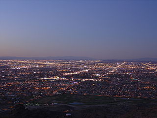
Phoenix is the capital and most populous city of the U.S. state of Arizona, with 1,608,139 residents as of 2020. It is the fifth-most populous city in the United States and the most populous state capital in the country.

Mountain America Stadium is an outdoor college football stadium in the southwestern United States, on the campus of Arizona State University (ASU) in Tempe, Arizona. The stadium is officially named Mountain America Stadium, Home of the ASU Sun Devils. It was named Sun Devil Stadium until 2023. It is home to the ASU Sun Devils football team of the Pac-12 Conference. The stadium's seating capacity as of 2018 is 53,599, reduced from a peak of 74,865 in 1989. The natural grass playing surface within the stadium was named Frank Kush Field in 1996 in honor of the former coach of the team. The stadium underwent a five-year, $304-million renovation that was completed in August 2019.

Scottsdale is a city in the eastern part of Maricopa County, Arizona, United States, and is part of the Phoenix metropolitan area. Named Scottsdale in 1894 after its founder Winfield Scott, a retired U.S. Army chaplain, the city was incorporated in 1951 with a population of 2,000. At the 2020 census, the population was 241,361, which had grown from 217,385 in 2010. Its slogan is "The West's Most Western Town". Over the past two decades, it has been one of the fastest growing cities and housing marketings in the United States.

Tempe is a city in Maricopa County, Arizona, United States, with the Census Bureau reporting a 2020 population of 180,587. The city is named after the Vale of Tempe in Greece. Tempe is located in the East Valley section of metropolitan Phoenix; it is bordered by Phoenix and Guadalupe on the west, Scottsdale and the Salt River Pima–Maricopa Indian Community on the north, Chandler on the south, and Mesa on the east. Tempe is also the location of the main campus of Arizona State University.

Phoenix Sky Harbor International Airport is a civil–military public airport 3 miles east of downtown Phoenix, in Maricopa County, Arizona, United States. It is Arizona's largest and busiest airport; among the largest commercial airports in the United States, PHX was the 8th-busiest airport in the United States and 22nd-busiest in the world in 2021. The airport serves as a hub for American Airlines and a base for Frontier Airlines and Southwest Airlines.

Pedestrian zones are areas of a city or town restricted to use by people on foot or human-powered transport such as bicycles, with non-emergency motor traffic not allowed. Converting a street or an area to pedestrian-only use is called pedestrianisation.

Ahwatukee Foothills is an urban village of Phoenix, Arizona. Ahwatukee forms the southernmost portion of Phoenix, and is considered part of the East Valley region of the Phoenix metropolitan area.

Arizona State Route 202 (SR 202) or Loop 202 (202L) is a semi-beltway circling the eastern and southern areas of the Phoenix metropolitan area in central Maricopa County, Arizona. It traverses the eastern end and the southern end of the city of Phoenix, in addition to the cities of Tempe, Mesa, Chandler, and Gilbert, and is a vital route in the metropolitan area freeway system. Loop 202 has three officially designated sections along its route; the Red Mountain Freeway, the SanTan Freeway, and the Congressman Ed Pastor Freeway, also known as the South Mountain Freeway. The Red Mountain Freeway runs from the Mini Stack Interchange with Interstate 10 (I-10) and State Route 51 (SR 51) in Phoenix to the SuperRedTan Interchange with U.S. Route 60 (US 60) in Mesa. The SanTan Freeway runs from there to an interchange with Interstate 10 (I-10) in Chandler. The Congressman Ed Pastor Freeway runs from there to I-10 in western Phoenix.

A carfree city is an urban area absent of motor vehicles. Carfree cities rely on public transport, walking, and cycling for travel as opposed to motor vehicles. Districts where motor vehicles are prohibited are referred to as carfree zones. Carfree city models have gained traction in the second half of the 20th century due to issues with congestion and infrastructure, and proposed environmental and quality of life benefits. Many cities in Asia, Europe, and Africa have carfree areas due to the cities being created before the invention of motor vehicles, while many developing cities in Asia are using the carfree model to modernize their infrastructure.
Fiesta Mall is a former shopping mall in Mesa, Arizona, United States. Opened in 1979 after nine years of development, it was built by Homart Development Company, the former shopping mall development division of the department store Sears. Sears was the first anchor store to open in the mall, doing so in 1977. Also present as anchor stores were The Broadway and Goldwater's, with Diamond's following in 1980. The mall began experiencing declines in traffic following the opening of Arizona Mills in 1997, and saw numerous anchor store and inline tenancy changes. After a long period of decline, it was shuttered in January 2018.
South Phoenix is a region of Phoenix, Arizona. By one definition it encompasses an area south of the Salt River, north of Roeser Road, east of 24th Street, and west of 32nd Street.
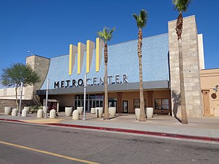
Metrocenter was a regional enclosed shopping mall in northwest Phoenix, Arizona. It was bounded by Interstate 17, 31st, Dunlap and Peoria Avenues. Before its closure, the three most recently open anchor stores were Harkins Theatres, Walmart Supercenter, and Dillard's Clearance Center; three additional vacant anchor stores included former Sears, JCPenney, and Macy's locations. The mall featured 100 stores, a 12 screen movie theater, and a food court. Since January 2021, the mall had been owned by the Carlyle Development Group based in New York City. The mall officially closed on June 30, 2020.
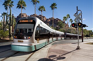
Valley Metro Rail is a 29.8-mile (48 km) light rail system serving the cities of Phoenix, Tempe, and Mesa in Arizona, USA. The network, which is part of the Valley Metro public transit system, began operations on December 27, 2008. In 2023, the system had a ridership of 10,797,600, or about 33,000 per weekday as of the fourth quarter of 2023.

Tempe station is a former train station in Tempe, Arizona. Previously, Amtrak's Sunset Limited and Texas Eagle trains stopped at the station, but they were shifted to a more southerly route in June 1996. However, an Amtrak Thruway shuttle route connects the station to the Maricopa station on the new routing.

A pedestrian village is a compact, pedestrian-oriented neighborhood or town with a mixed-use village center. Shared-use lanes for pedestrians and those using bicycles, Segways, wheelchairs, and other small rolling conveyances that do not use internal combustion engines. Generally, these lanes are in front of the houses and businesses, and streets for motor vehicles are always at the rear. Some pedestrian villages might be nearly car-free with cars either hidden below the buildings, or on the boundary of the village. Venice, Italy is essentially a pedestrian village with canals. Other examples of a pedestrian village include Giethoorn village located in the Dutch province of Overijssel, Netherlands, Mont-Tremblant Pedestrian Village located beside Mont-Tremblant, Quebec, Canada, and Culdesac Tempe in Tempe, Arizona.
A robotaxi, also known as robot taxi, robo-taxi, self-driving taxi or driverless taxi, is an autonomous car operated for a ridesharing company.

The Tempe Streetcar, referred to as the Streetcar Line on regional transit maps, is a streetcar extension of Phoenix's Valley Metro Rail system. Construction began in 2017, and the line opened for service on May 20, 2022. It serves 14 stops across three miles of track serving various parts of the city's downtown, as well as the Tempe campus of Arizona State University, with the Valley Metro Rail main line.
This is a list of George Floyd protests in Arizona, United States. Protests occurred in at least nineteen communities in the state, with protests continuing for five weeks in Phoenix.
References
- ↑ "Culdesac | Details, Details, Details!". culdesac.com.
- ↑ Bliss, Laura (September 8, 2021). "Developers Offer Mobility Services to Lure Car-Free Renters". Bloomberg News . Retrieved August 17, 2023.
- ↑ Kusisto, Laura (November 19, 2019). "New Arizona Development Bans Residents From Bringing Cars". The Wall Street Journal . Retrieved August 17, 2023.
- ↑ Polakoff, Elliott (August 1, 2023). "Tempe car-free neighborhood seeks to change the way people live". AZ Family . Retrieved September 18, 2023.
- 1 2 Johnson, Ryan (June 22, 2020). "Introducing Culdesac". Medium. Retrieved November 10, 2020.
- ↑ Dougherty, Conor (October 31, 2020). "The Capital of Sprawl Gets a Radically Car-Free Neighborhood". The New York Times. ISSN 0362-4331 . Retrieved November 10, 2020.
- 1 2 Richardson, Brenda. "Developer Breaks Ground On A Neighborhood In Tempe, Arizona, For People—And No Cars". Forbes. Retrieved November 10, 2020.