Kurdistan or Kordestan province is one of the 31 provinces of Iran. The province is 28,817 km2 in area and its capital is the city of Sanandaj. Other counties with their major cities are Saqqez, Baneh, Marivan, Qorveh, Bijar, Kamyaran, Dehgolan, Diwandarreh and Sarvabad.

Ravansar, also Romanized as Ravānsar and Rawānsīr, is a city in the Central District of Ravansar County, Kermanshah province, Iran, serving as capital of both the county and the district.

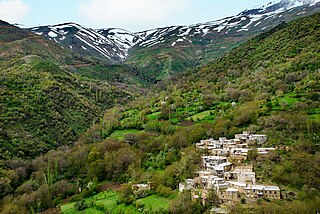
Avroman or Hawraman, is a mountainous region located within the provinces of Kurdistan and Kermanshah in western Iran and in north-eastern Kurdistan Region in Iraq. The main part of the Hawraman region is located in Iran and encompasses two components of the Central-Eastern Valley ; and the Western Valley. The mode of human habitation in these two valleys has been adapted over millennia to the rough mountainous environment. Tiered steep-slope planning and architecture, gardening on dry-stone terraces, livestock breeding, and seasonal vertical migration are among the distinctive features of the local culture and life of the Hawrami Kurdish people who dwell in lowlands and highlands during different seasons of each year. On July 27, 2021, part of the Hawraman region along with Uramanat were inscribed on the UNESCO World Heritage List as a cultural site under the name "Cultural Landscape of Hawraman/Uramanat".
The Baradostian culture was an Upper Paleolithic flint industry culture found in the Zagros region in the border-country between Iraq and Iran. It was preceded by the Middle Paleolithic Mousterian culture, directly overlying it without an intervening bladelet industry. This culture is known for the high percentage of burins and some of these were similar to the distinctive nosed profile of the Aurignacian burins. Baradost is one of the mountains in the Zagros Mountains in Iraq.
Sefid-Ab is an archeological site in central Iran and is the first known evidence for Upper Paleolithic occupation of that region.
Warwasi is a Paleolithic rockshelter site located at north of Kermanshah in western Iran. It was excavated by Bruce Howe under direction of late Robert Braidwood in the 1960s. This site contains a rich archaeological sequence from Middle Paleolithic to late Epipaleolithic.

Yafteh is an Upper Paleolithic cave located at the foot of Yafteh Mountain in the Zagros Mountains range, located northwest of Khoramabad in western Zagros, Lorestan Province of western Iran.
Fereidoun Biglari is an Iranian archaeologist and a museum curator.

Zagros Paleolithic Museum is a museum in Kermanshah, Iran, established in 2008. The museum contains stone tools and animal fossil bones from Paleolithic sites in Iran.

Qal'eh Bozi is a complex of caves sites located about 25 km (15.5 mi) south-southwest of Isfahan, Iran; northeast of Dizicheh and north of Hassanabad. The sites include two rock shelters and a cave located at altitudes between 1,750 and 1,810 m above sea level. The caves are found on the southern face of a limestone mountain of lower Cretaceous age that rises to more than 500 m (1,640.4 ft) above the plain floor. From the cave entrance there is a commanding view of the plain below and of the Zaiandeh Rud River flowing about 2 km (1.2 mi) to the south and southeast.
The Parchments of Avroman are three parchment documents, found in 1909 in a cave in the Hawraman region of Iranian Kurdistan. They were found in Tang-i Var, Kuh-e Salan Mountain, near the village of Shahr Hawraman. The documents were found in a sealed jar by a villager, and then sent to London in October 1913.

The prehistory of the Iranian plateau, and the wider region now known as Greater Iran, as part of the prehistory of the Near East is conventionally divided into the Paleolithic, Epipaleolithic, Neolithic, Chalcolithic, Bronze Age and Iron Age periods, spanning the time from the first settlement by archaic humans about a million years ago until the beginning of the historical record during the Neo-Assyrian Empire, in the 8th century BC.

Maiwala or Farokhshad is a mountain of the Zagros Mountains, located in western Iran, north of the city of Kermanshah. It is one of the mountains of Paraw range, with an altitude of 2445 above sea level. It is about 5 km long from the Tang-e Malavard at west to Taq-e Kenesht at east. The mountain contains several archaeological caves.

Darian Dam was constructed on the Sirwan River between 2009 and 2015. The Dam is located in the Hawrāmān region of Kurdistan and Kermanshah. The Darian Dam Archeological Salvage Program (DDASP) was planned by the Iranian Center for Archaeological Research before flooding the reservoir.
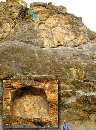
The Inscription of Sargon II at Tang-i Var is carved on the flanks of the Zinanah Mt. in the Tang-i Var pass in Hawraman, Iranian Kurdistan, about 50 km southwest of Sanandaj. It was discovered during an archaeological survey carried out by Sardaraz in 1968.
Malaverd is an archaeological site in the north of Kermanshah, in Iran. It is located in the Tang-e Malaverd valley, at the western end of Mount Meywala, about 8 km (26,247 ft) from the west of Taq-e Bostan. Malaverd is one of the Paleolithic cave sites in the south of Mount Meywala. This site was recorded during a survey conducted be Fereidoun Biglari in 1999 and registered in the Iran National Heritage List in 2005. The site was excavated by a team of archaeologists under the direction of Sonia Shidrang in August 2012. The site contained a 170 cm thick sequence of archaeological deposits. The excavations revealed that the cave was occupied during the Middle Paleolithic, Upper Paleolithic, Chalcolithic, Iron Age III, and Parthian. The cave is the first Upper Paleolithic site in the Kermanshah region that was excavated by an Iranian archaeologist and the first dated Upper Paleolithic site in the region. The other important cave site near Malaverd is Do-Ashkaft Cave.
Darai Rockshelter is an archaeological site in the southwest of Kurdistan Province, in west Iran. It is located in the Sirwan River valley, between Naw and Asparez villages, in the Hawraman region. It faces NNW at an altitude of 760m a.s.l.The shelter was discovered during Darian Dam Archaeological Salvage Program in 2015, excavated in 2015–2016, and it was subsequently submerged in 2016.
The Archaeology of Iran encompasses the following subjects:

