
Patilla Pata is a stratovolcano in the Oruro Department in Bolivia. It is situated in the Sajama Province, in the west of the Curahuara de Carangas Municipality, at the border with Chile. Patilla Pata lies south-west of the mountain Jisk'a Kunturiri, north-east of the lake Q'asiri Quta (Khasiri Kkota) and the mountain Qullqi Warani, west of the little lake Sura Pata, south-east of the mountains Laram Q'awa, Kunturiri and Milluni and south of the little lake named Ch'iyar Quta.

Pomerape is a stratovolcano lying on the border of northern Chile and Bolivia. It is part of the Payachata complex of volcanoes, together with Parinacota Volcano to the south. The name "Payachata" means "twins" and refers to their appearance. It hosts glaciers down to elevations of 5,300–5,800 metres (17,400–19,000 ft), lower on the northern slope.

Payachata or Paya Chata is a north-south trending complex of potentially active volcanos on the border of Bolivia and Chile, directly north of Chungará Lake. The complex contains two peaks, Pomerape to the north and Parinacota to the south. On the Bolivian side the volcanoes are located in the Oruro Department, Sajama Province, Curahuara de Carangas Municipality, and on the Chilean side they lie in the Arica y Parinacota Region, Parinacota Province.
Sajama is a province in the northwestern parts of the Bolivian Oruro Department.

Turco Municipality is the second municipal section of the Sajama Province in the Oruro Department in Bolivia, and was founded on February 15, 1957. Its seat is Turco, situated 154 km west of Oruro at an altitude of 3,860 m. The municipality covers an area of 3,973 km², not taking into account the area of Laca Laca Canton.

K'isi K'isini is a 5,536-metre-high (18,163 ft) mountain in the Cordillera Occidental in the Andes of Bolivia. It is located in the Oruro Department, Sajama Province, Curahuara de Carangas Municipality, Sajama Canton. K'isi K'isini is situated inside the boundaries of the Sajama National Park, south-east of the Parina Quta and Pomerape volcanoes and north of the Bolivian route 4 that leads to the Chungara–Tambo Quemado mountain pass on the border with Chile.

Ch'iyar Quta is a small Bolivian lake located in the Sajama Province of the Oruro Department near the border to Chile. It is situated at a height of about 5,090 meters inside the boundaries of the Sajama National Park. Ch'iyar Quta lies south-east of the peaks of Laram Q'awa, Milluni and Kunturiri, south-west of Jisk'a Kunturiri and north of Patilla Pata.
Jach'a Kunturiri is a 5,326-metre-high (17,474 ft) mountain in the Andes of Bolivia. It is situated in the Oruro Department, Sajama Province, Curahuara de Carangas Municipality, Sajama Canton, near the border to the La Paz Department. Jach'a Kunturi lies north-east of the mountains Kunturiri and Jisk'a Kunturiri and north-west of the extinct Sajama volcano.

Kunturiri is a volcano in the Andes on the border of Bolivia and Chile which rises up to 5,762 metres (18,904 ft). On the Chilean side it is located in the Arica and Parinacota Region and on the Bolivian side in the Oruro Department, Sajama Province, Curahuara de Carangas Municipality, Sajama Canton as well as in the La Paz Department, Pacajes Province, Calacoto Municipality, Ulloma Canton.
Jisk'a Kunturiri is a mountain in the Andes of Bolivia which rises up to 5,488 metres (18,005 ft). It is situated in the Oruro Department, Sajama Province, Curahuara de Carangas Municipality, Sajama Canton, north-west of the extinct Sajama volcano. Kunturi lies south-west of the mountains Jach'a Kunturiri and Pumuta, north-east of Patilla Pata and the small lake named Ch'iyar Quta and east of the mountain Kunturiri.
Pumuta is a mountain in the Andes of Bolivia, about 5,200 metres (17,060 ft) high. It is situated in the Oruro Department, Sajama Province, Curahuara de Carangas Municipality, Sajama Canton, north-west of the extinct Sajama volcano. Pumuta lies south-west of the mountain Jach'a Kunturiri and north-east to east of the mountains Kunturiri and Jisk'a Kunturiri.

Qullqi Warani is a mountain in the Oruro Department in Bolivia at the border with Chile, north-west of the extinct Sajama volcano. It is situated in the Sajama Province, in the west of the Curahuara de Carangas Municipality. According to the Bolivian IGM map 1:50,000 'Nevados Payachata Hoja 5739-I' it lies entirely on Bolivian terrain. Qullqi Warani lies south-west of the mountains Jisk'a Kunturiri and Patilla Pata, north of Phaq'u Q'awa and south-east of Kunturiri. The little lakes Q'asiri Quta (Khasiri Kkota) and Sura Pata (Sora Pata, Sorapata) lie at its feet, east and north of it.
Phaq'u Q'awa is a mountain in the Cordillera Occidental in the Andes of Bolivia, about 5,380 metres (17,651 ft) high. It is situated in the Oruro Department, Sajama Province, in the west of the Curahuara de Carangas Municipality, northwest of the extinct Sajama volcano. It lies south of Qullqi Warani.
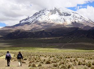
Wisalla is a 5,031-metre-high (16,506 ft) mountain in the Andes of Bolivia. It is situated in the Oruro Department, Sajama Province, Curahuara de Carangas Municipality. Wisalla lies south-west of the dormant Sajama volcano.
Llisa is a 4,708-metre-high (15,446 ft) mountain in the Andes of Bolivia. It is located in the Oruro Department, Sajama Province, Curahuara de Carangas Municipality. Llisa lies northeast of the Sajama volcano.
Jach'a Apachita is a mountain in the Andes of Bolivia which reaches a height of approximately 4,920 m (16,140 ft). It is located in the Oruro Department, Sajama Province, in the southeast of the Curahuara de Carangas Municipality.
Janq'u Laqaya is a mountain in the Andes of Bolivia which reaches a height of approximately 4,300 m (14,100 ft). It is located in the Oruro Department, Sajama Province, Curahuara de Carangas Municipality, south of Ch'apiri.
Ch'apiri is a 4,302-metre-high (14,114 ft) mountain in the Andes of Bolivia. It is located in the Oruro Department, Sajama Province, Curahuara de Carangas Municipality. It lies east of a village of that name. The Ch'apiri River originates at the mountain.. It flows to Curahuara de Carangas in the north.


