The Big Spring School District is a midsized, rural, public school district which serves the residents of the Borough of Newville and Cooke Township, Lower Frankford Township, Lower Mifflin Township, North Newton Township, Penn Township, South Newton Township, Upper Frankford Township, Upper Mifflin Township and West Pennsboro Township in Cumberland County, Pennsylvania. Big Spring School District encompasses approximately 198 square miles (510 km2). By 2010, the district's population increased to 19,098 people. According to 2008 local census data it served a resident population of 18,665. The educational attainment levels for the Big Spring School District population were 84.3% high school graduates and 14% college graduates. The district is one of the 500 public school districts of Pennsylvania.

The Penn-Delco School District is a midsized, suburban public school district in Delaware County, Pennsylvania, that encompasses the following municipalities: Aston Township, Brookhaven Borough, and Parkside Borough. Penn-Delco School district encompasses approximately 9 square miles. According to 2010 local census data it serves a resident population of 26,455. In 2009, the district residents’ per capita income was $23,035, while the median family income was $61,417. In the Commonwealth, the median family income was $49,501 and the United States' median family income was $49,445, in 2010.
The Palmyra Area School District is the public school system in southwest Lebanon County, Pennsylvania.
The Jim Thorpe Area School District is located in Carbon County, Pennsylvania, United States. It comprises the borough of Jim Thorpe and the townships of Penn Forest and South Kidder. It covers a total area of 137 square miles (350 km2).

The Boyertown Area School District is a large public school district which covers portions of Berks and Montgomery Counties in southeastern Pennsylvania. When the Boyertown Area School District was formed in 1953 it was one of the largest in the state, encompassing 100 square miles (260 km2). In Berks County it covers the Boroughs of Bally, Bechtelsville and Boyertown and Colebrookdale Township, Douglass Township, Earl Township and Washington Township. In Montgomery County it covers Douglass Township, New Hanover Township and Upper Frederick Township.
The Wyalusing Area School District is a small enrollment, rural, public school district in northern Pennsylvania. It spans portions of two counties. Wyalusing Area School District encompasses approximately 273 square miles (710 km2). In southeastern Bradford County the district serves the Boroughs of New Albany and Wyalusing and Albany Township, Herrick Township, Overton Township, Stevens Township, Terry Township, Tuscarora Township, Wilmot Township and Wyalusing Township. In northwestern Wyoming County it serves the Borough of Laceyville and Braintrim Township and the northern and eastern portions of Windham Township. According to 2010 federal census data, it serves a resident population of 9,202. In 2009, the Wyalusing Area School District residents' per capita income was $16,780, while the median family income was $38,279. In the Commonwealth, the median family income was $49,501 and the United States median family income was $49,445, in 2010. By 2013, the median household income in the United States rose to $52,100.

The Brockway Area School District is a small, rural public school district located in north west Pennsylvania, US. The District encompasses approximately 147 square miles (380 km2) spanning portions of two counties. In Elk County it covers a small portion of Horton Township. In Jefferson County it covers the Borough of Brockway and Polk Township, Snyder Township and Washington Township. The district operates one elementary school and Brockway Area Junior/Senior High School. The district is with the Riverview Intermediate Unit 6 region. The Intermediate Unit provides support services and therapy to special education students. It also provides training to school personnel.
The Antietam School District is a diminutive, suburban public school district that serves the Borough of Mount Penn and Lower Alsace Township in Berks County, Pennsylvania. It encompasses approximately 5 square miles (13 km2). According to a federal census, it served a resident population of 7,494. In 2009, the district residents’ per capita income was $22,716, while the median family income was $49,511. In the Commonwealth, the median family income was $49,501 and the United States median family income was $49,445, in 2010.
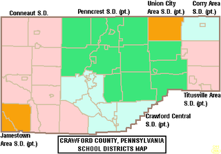
The Crawford Central School District is a midsized, public school district in Crawford County, Pennsylvania. It serves the City of Meadville, Borough of Cochranton and East Fairfield Township, Fairfield Township, Union Township, Vernon Township, Wayne Township and West Mead Township as well as a small portion of Greenwood Township in Crawford County, Pennsylvania, as well as French Creek Township in neighboring Mercer County, Pennsylvania. Crawford Central School District encompasses approximately 156 square miles. According to 2000 federal census data, it serves a resident population of 30,882 people. By 2010, the district's population declined to 30,635 people. In 2009, the Crawford Central School District residents' per capita income was $18,463, while the median family income was $43,771. In the Commonwealth, the median family income was $49,501 and the United States median family income was $49,445, in 2010. By 2013, the median household income in the United States rose to $52,100.

The Crestwood School District is a midsized, suburban public school district which serves the Boroughs of Nuangola, Penn Lake Park and White Haven and Dennison Township, Dorrance Township, Fairview Township, Rice Township, Slocum Township and Wright Township in Luzerne County, Pennsylvania. Crestwood School District encompasses approximately 109.5 square miles (284 km2). According to 2000 federal census data, it serves a resident population of 18,299.
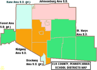
The Saint Marys Area School District is a midsized rural/suburban public school district serving parts of Elk County, Pennsylvania. It encompasses the city of St. Marys and the townships of Fox Township, Jay Township, and Benezette Township. Saint Marys Area School District encompasses approximately 341 square miles (880 km2). According to 2000 federal census data, the district serves a resident population of 20,557. In 2009, the district residents’ per capita income was $18,669, while the median family income was $48,121. In the Commonwealth, the median family income was $49,501 and the United States median family income was $49,445, in 2010.

The West Middlesex Area School District is a small, rural public school district serving the southwestern portion of Mercer County, Pennsylvania. It encompasses the communities of West Middlesex, Shenango Township, and Lackawannock Township. The West Middlesex Area School District encompasses approximately 52 square miles (130 km2). The district operates on a single 40-acre campus. According to 2000 federal census data, it served a resident population of 7,527. By 2010, the district's population declined to 7,454 people. In 2009, the district residents’ per capita income was $16,870, while the median family income was $40,558. In the Commonwealth, the median family income was $49,501 and the United States median family income was $49,445, in 2010.

The Penns Valley Area School District is a small rural, public school district serving the south-eastern portions of Centre County, Pennsylvania. It encompasses the boroughs of Centre Hall and Millheim, Pennsylvania, as well as the townships of Potter, Gregg, Penn, Miles, and Haines. It encompasses an area of 254.4 square miles (659 km2). The school district had a population of 11,380, according to the 2000 federal census. By 2010, the district's population grew to 12,830 people. The educational attainment levels for the Penns Valley Area School District population were 87% high school graduates and 21.5% college graduates. The district is one of the 500 public school districts of Pennsylvania.

The Waynesboro Area School District is a midsized, suburban public school district located in Franklin County, Pennsylvania. The district is one of the 500 public school districts of Pennsylvania. It encompasses the boroughs of Waynesboro and Mont Alto, as well as all of Washington Township and Quincy Township, and a portion of Guilford Township. Waynesboro Area School District encompasses approximately 93 square miles (240 km2). According to 2000 federal census data, it serves a resident population of 28,376. By 2010, the district's population increased to 32,386 people. In 2009, the district residents' per capita income was $18,503, while the median family income was $46,584. In the Commonwealth, the median family income was $49,501 and the United States median family income was $49,445, in 2010.

The Wellsboro Area School District is a small, rural/suburban public school district located in central Tioga County. Wellsboro Area School District encompasses approximately 330 square miles (850 km2). The district serves the borough of Wellsboro and also serves: Middlebury Township, Charleston Township, Delmar Township, Duncan Township, and Shippen Township. Pine Township in Lycoming County, Pennsylvania, which is not connected to the rest of the district, is also served. According to 2000 federal census data, the district served a resident population of 11,689. By 2010, the District's population rose slightly to 11,800 people. The educational attainment levels for the Wellsboro Area School District population were 90.2% high school graduates and 24.3% college graduates. The district is one of the 500 public school districts of Pennsylvania.
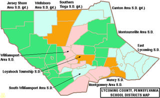
The South Williamsport Area School District is a small public school district in Lycoming County, Pennsylvania, in the United States. The school serves several suburbs of Williamsport, including South Williamsport, DuBoistown, Susquehanna Township, and Armstrong Township. The district encompasses approximately 36 square miles (93 km2). According to 2000 federal census data, it served a resident population of 9,400. By 2010, the district's population declined to 9,268 people. In 2009, the district residents’ per capita income was $18,650, while the median family income was $41,002. In the Commonwealth, the median family income was $49,501 and the United States median family income was $49,445, in 2010. By 2013, the median household income in the United States rose to $52,100.

The Montrose Area School District is a small, rural public school district that is located in northwestern Susquehanna County, Pennsylvania. It serves the following municipalities: Montrose, Bridgewater Township, Franklin Township, Liberty Township, Jessup Township, Forest Lake Township, Silver Lake Township, Little Meadows, Choconut Township, Friendsville, and Middletown Township.
The Northern Tioga School District is a rural public school district operating in Tioga County, Pennsylvania, US. The district serves an extensive rural region, spanning 335 square miles (870 km2) across the northern section of Tioga County. Northern Tioga School District is a third class school district having less than 30,000 residents and is one of the 500 public school districts of Pennsylvania. Municipalities served include: Tioga, Tioga Township, Jackson Township, Lawrenceville, Lawrence Township, Farmington Township, Elkland, Osceola Township, Knoxville, Chatham Township, Deerfield Township, Brookfield, Westfield, and Clymer Township. According to 2000 federal census data, it served a resident population of 14,670. By 2010, the district's population declined to 14,523 people. The educational attainment levels for the Northern Tioga School District population were 85.6% high school graduates and 11.7% college graduates.
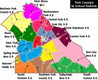
South Western School District is a midsized, suburban public school district in York County, Pennsylvania. It serves the townships of Penn Township, Manheim Township and West Manheim Township. It encompasses approximately 56 square miles (150 km2). According to 2000 federal census data, South Western School District serves a resident population of 22,576 people. By 2010, the district's population increased to 26,768 people. In 2009, South Western School District residents’ per capita income was $20,618, while the median family income was $56,296. In the Commonwealth, the median family income was $49,501 and the United States median family income was $49,445, in 2010.
The South Eastern School District is a midsized, rural, public school district in southern York County, Pennsylvania. It serves the boroughs of Cross Roads, Stewartstown, Delta, and Fawn Grove, plus the townships of Hopewell Township, East Hopewell Township, Fawn Township, and Peach Bottom Township. It also includes the villages of Bryansville and Woodbine. The district encompasses approximately 105 square miles (270 km2). According to data from the 2000 federal census, it serves a resident population of 17,884 people. By 2010, South Eastern School District's population increased to 19,567 people. In 2009, the district residents’ per capita income was $20,060, while the median family income was $55,846. In the Commonwealth, the median family income was $49,501 and the United States median family income was $49,445, in 2010.