Cushendall

Last updated

Cushendall
Cushendall2.jpg
Cushendall village with hurling mural
United Kingdom Northern Ireland adm location map.svg
Red pog.svg
Cushendall
Location within Northern Ireland
Population1,280 (2011 Census)
District
County
Country Northern Ireland
Sovereign state United Kingdom
Post town BALLYMENA
Postcode district BT44
Dialling code 044
UK Parliament
NI Assembly
List of places
UK
Northern Ireland
Antrim
55°04′58″N6°03′32″W / 55.082887°N 6.05896°W / 55.082887; -6.05896

Cushendall (from Irish Cois Abhann Dalla, meaning 'foot of the River Dall'), [1] [3] formerly known as Newtownglens, [3] is a coastal village and townland (of 153 acres) in County Antrim, Northern Ireland. It is located in the historic barony of Glenarm Lower and the civil parish of Layd, [4] and is part of Causeway Coast and Glens district.

Contents

Located on the A2 coast road between Glenariff and Cushendun, Cushendall is in the Antrim Coast and Glens an Area of Outstanding Natural Beauty. It lies in the shadow of the table topped Lurigethan Mountain and at the meeting point of three of the Glens of Antrim: Glenaan, Glenballyemon and Glencorp. This part of the Northern Irish coastline is separated from Scotland by the North Channel, with the Mull of Kintyre about 16 miles away. In the 2011 Census, Cushendall had a population of 1,280 people. [5]

Much of the historic character of the 19th century settlement on the north bank of the River Dall remains, including the mostly-intact Irish Georgian buildings of the town's four original streets. In 1973, it was the second village in Northern Ireland to be designated as a Conservation Area. Since 1990, Cushendall has hosted the Heart Of The Glens festival every August. Thomas D'Arcy McGee, a father of Canadian Confederation, spent his childhood in Cushendall when his father, who worked for the Coast Guard Service, was posted there. [6]

Places of interest

The Curfew Tower. Curfew Tower - geograph.org.uk - 467680.jpg
The Curfew Tower.

Curfew Tower

The Curfew Tower in the centre of the village was built in 1817 to confine riotous prisoners by Francis Turnley — landlord of the town at the time. Dan McBride, an army pensioner, was given the job of permanent garrison and was armed with one musket, a bayonet, a brace of pistols and a thirteen-foot-long pike. The tower is now owned by Scottish musician and artist Bill Drummond.

Oisin's Grave

Oisín's Grave, off the main Cushendall to Ballymoney road, is a megalithic court cairn on a hillside in Lubitavish, near the Glenann River. It is believed to be the burial place of Oísín — the Celtic warrior poet. A stone cairn was erected on the site in 1989 in memory of John Hewitt, the poet of the Glens.

Layd Church and Churchyard

The ruins of Layd Church, [7] a Franciscan foundation possibly partially from the 13th century, are about 1.5 km north of Cushendall. They are also accessible by road and a cliff path from Cushendall. There are old vaults in the churchyard and it was one of the main burial places of the MacDonnells. There is a stone cross memorial to Dr James MacDonnell, one of the organisers of the last Belfast Festival of Harpists in 1792 and pioneer of the use of chloroform in surgery. By the gate of the churchyard is a holestone and nearby two 'corp stones' on which coffins were rested. [8] Layd Church saw service as a parish church from 1306 until about 1790. [9] [10]

Red Bay Castle

Red Bay Castle, situated between the villages of Cushendall and Waterfoot. Built by the Bisset family in the 14th century and later occupied by the MacDonnells, one of the outposts of the Kingdom of Dál Riata.

Glenariff Forest Park

Glenariff Forest Park, about 8 km inland from Cushendall, covers an area of 1185 hectares. The park contains waterfalls, forest trails, and riverside walks, including a café, toilets, and an exhibition centre. Four way-marked trails of varying length (1–9 km) wind through the forest leading walkers into some of the park's wooded areas.

History

Cushendall Beach as seen from the Salmon Rocks, with Lurigethan in the background. Cushendall Beach - geograph.org.uk - 467693.jpg
Cushendall Beach as seen from the Salmon Rocks, with Lurigethan in the background.

During The Troubles in Northern Ireland from 1920 to 1922, a shooting occurred in Cushendall. Several lorries of Ulster Special Constabulary (USC) personnel, accompanied by British Army soldiers, drove into Cushendall on the night of 23 June 1922 to enforce the nightly curfew. The USC proceeded to open fire on a crowd of onlookers, killing three Catholic men: James McAllister, John Gore and John Hill. [11] After the incident, the USC claimed they were ambushed by the Irish Republican Army and returned fire, but a British government inquiry, which was declassified almost a century later, concluded that the constabulary's version of events was false. [12]

There were further violent incidents during the Troubles of the late 20th century.

Demographics

Cushendall is classified as a village by the Northern Ireland Statistics and Research Agency (NISRA) (i.e., with a population between 1,000 and 2,499 people). [16] On Census Day (27 March 2011) the usually resident population of Cushendall Settlement was 1,280, accounting for 0.07% of the NI total. [5] Of these:

Sport

Hurling

Founded in 1906, the local hurling club Ruairí Óg plays its home matches at Páirc Mhuire in Cushendall. They became Ulster champions for the first time in the 1981-82 season, when the team captained by John Delargy beat Ballycastle Mc Quillans after a replay. And as of 2022, have been Ulster champions 11 times (All Ireland Senior Club Hurling Championships). They have reached the final of the All Ireland Senior Club Hurling Championships once in the 2015-16 season, losing to Na Piarsaigh (Limerick) 2-25 to 2-14.

Golf

Cushendall Golf Club is a small nine-hole course primarily aiming to improve short game. The course is located in a valley with the Abhainn Dala (River Dall) running through its centre to the sea.

Sailing

Established in 1951, Cushendall Sailing & Boating Club is the ideal place to learn basic introductory, as well as advanced Sailing skills. The club is situated in Red Bay and the views of the surrounding Glens of Antrim make a stunning backdrop for those on the waves. Cushendall CSBC has a sailing school which runs throughout the summer using RYA's learn-to-sail scheme. The school welcomes all ages and abilities, ensuring progression is achieved by each individual student.

Running

The second Saturday of August each year during the Heart of the Glens Festival the Lurig Run takes place. This challenge is a 3.5 mile run consisting of a 1500 ft climb up the face of the Lurigethan mountain. Growing in popularity among the running elite, it is seen as one of the most challenging organised runs in Northern Ireland. 400 people compete each year. [ citation needed ]

Tourism

Holiday accommodation in the area ranges from Self Catering to Bed & Breakfast and caravan and camping. Cushendall has three caravan and camping sites. [17]

Cushendall offers a diverse range of shops, which offer local gifts and crafts, as well as many other items.

There is also an annual vintage car rally which is held in the village. [18]

Notable people

Related Research Articles

<span class="mw-page-title-main">County Antrim</span> Historic Northern Ireland county

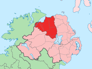
County Antrim is one of the six counties of Northern Ireland, located within the historic province of Ulster. Adjoined to the north-east shore of Lough Neagh, the county covers an area of 3,086 square kilometres (1,192 sq mi) and has a population of 651,321, as of the 2021 census. County Antrim has a population density of 211 people per square kilometre or 546 people per square mile. It is also one of the thirty-two traditional counties of Ireland.

<span class="mw-page-title-main">County Londonderry</span> County in Northern Ireland

County Londonderry, also known as County Derry, is one of the six counties of Northern Ireland, one of the thirty-two counties of Ireland and one of the nine counties of Ulster. Before the partition of Ireland, it was one of the counties of the Kingdom of Ireland from 1613 onward and then of the United Kingdom after the Acts of Union 1800. Adjoining the north-west shore of Lough Neagh, the county covers an area of 2,118 km2 (818 sq mi) and today has a population of about 252,231.

<span class="mw-page-title-main">Ballycastle, County Antrim</span> Seaside town in County Antrim, Northern Ireland

Ballycastle is a small seaside town in County Antrim, Northern Ireland. It is on the northeasternmost coastal tip of Ireland, in the Antrim Coast and Glens Area of Outstanding Natural Beauty. The harbour hosts the ferry to Rathlin Island and a smaller passenger and charter service to Campbeltown and Port Ellen in Scotland, with both Rathlin Island and Scotland's Kintyre peninsula able to be seen from the coast. The Ould Lammas Fair is held each year in Ballycastle on the last Monday and Tuesday of August. Ballycastle is the home of the Corrymeela Community.

<span class="mw-page-title-main">Newtownabbey</span> Town in County Antrim, Northern Ireland

Newtownabbey is a large settlement north of Belfast city centre in County Antrim, Northern Ireland. It is separated from the rest of the city by Cavehill and Fortwilliam golf course, but it still forms part of the Belfast metropolitan area. It surrounds Carnmoney Hill, and was formed from the merging of several small villages including Whiteabbey, Glengormley and Carnmoney. At the 2011 census, Metropolitan Newtownabbey Settlement had a population of 65,646, making it the third largest settlement in Northern Ireland. It is part of Antrim and Newtownabbey Borough Council.

<span class="mw-page-title-main">Ballymoney</span> Town in County Antrim, Northern Ireland

Ballymoney is a town and civil parish in County Antrim, Northern Ireland. It is within the Causeway Coast and Glens Borough Council area. The civil parish of Ballymoney is situated in the historic baronies of Dunluce Upper and Kilconway in County Antrim, as well as the barony of North East Liberties of Coleraine in County Londonderry. It had a population of 11,048 people at the 2021 Census.

<span class="mw-page-title-main">Glens of Antrim</span> Series of valleys in County Antrim, Northern Ireland

The Glens of Antrim, known locally as simply The Glens, is a region of County Antrim, Northern Ireland. It comprises nine glens (valleys), that radiate from the Antrim Plateau to the coast. The Glens are an area of outstanding natural beauty and are a major tourist attraction in north Antrim.

<span class="mw-page-title-main">Glenarm</span> Village in County Antrim, Northern Ireland

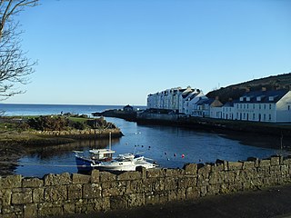
Glenarm is a village in County Antrim, Northern Ireland. It lies on the North Channel coast north of the town of Larne and the village of Ballygalley, and south of the village of Carnlough. It is situated in the civil parish of Tickmacrevan and the historic barony of Glenarm Lower. It is part of Mid and East Antrim Borough Council and had a population of 568 people in the 2011 Census. Glenarm takes its name from the glen in which it lies, the southernmost of the nine Glens of Antrim.

<span class="mw-page-title-main">Rasharkin</span> Village in County Antrim, Northern Ireland

Rasharkin is a small village, townland and civil parish in County Antrim, Northern Ireland. It is 13 kilometres (8.1 mi) south of Ballymoney, near Dunloy and Kilrea. It had a population of 1,114 people in the 2011 Census.

<span class="mw-page-title-main">Dunloy</span> Village in County Antrim, Northern Ireland

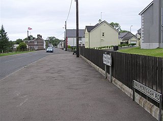
Dunloy is a village and townland in County Antrim, Northern Ireland. It is located 11 miles (18 km) north of Ballymena and 6 miles (10 km) north-west is Ballymoney. It is located in the civil parish of Finvoy, in the former barony of Kilconway. The village had a population of 1,194 people in the 2011 Census.

<span class="mw-page-title-main">Cloughmills</span> Village in County Antrim, Northern Ireland

Cloughmills or Cloghmills is a village in County Antrim, Northern Ireland. Ballymoney is 9 miles to the north-west and Ballymena is 10 miles to the south. It had a population of 1,309 people in the 2011 Census. It is in Causeway Coast and Glens District Council.

<span class="mw-page-title-main">Cushendun</span> Village in County Antrim, Northern Ireland

Cushendun is a small coastal village in County Antrim, Northern Ireland. It sits off the A2 coast road between Cushendall and Ballycastle. It has a sheltered harbour and lies at the mouth of the River Dun and Glendun, one of the nine Glens of Antrim. The Mull of Kintyre in Scotland is only about 15 miles away across the North Channel and can be seen easily on clear days. In the 2001 Census it had a population of 138 people. It is part of Causeway Coast and Glens district.

<span class="mw-page-title-main">Kilrea</span> Village in County Londonderry, Northern Ireland

Kilrea is a village, townland and civil parish in County Londonderry, Northern Ireland. It gets its name from the ancient church that was located near to where the current Church of Ireland is located on Church Street looking over the town. It is near the River Bann, which marks the boundary between County Londonderry and County Antrim. In the 2011 Census it had a population of 1,678 people. It is situated within Causeway Coast and Glens district.

<span class="mw-page-title-main">Waterfoot, County Antrim</span> Village in County Antrim, Northern Ireland

Waterfoot or Glenariff is a small coastal village in County Antrim, Northern Ireland. It is at the foot of Glenariff, one of the Glens of Antrim, within the historic barony of Glenarm Lower and the civil parishes of Ardclinis and Layd. The village is in the townland of Warren, 16 miles (26 km) north-east of Ballymena. The 2001 Census recorded a population of 504 inhabitants.

<span class="mw-page-title-main">Loughguile</span> Village in County Antrim, Northern Ireland

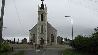
Loughguile, also spelt Loughgiel, is a village and civil parish in County Antrim, Northern Ireland. Situated 8 miles east of Ballymoney it is within the Causeway Coast and Glens Council area, and is at the edge of the Glens of Antrim. It had a population of 396 people in the 2011 Census.

<span class="mw-page-title-main">Armoy</span> Village in County Antrim, Northern Ireland

Armoy is a village and civil parish in County Antrim, Northern Ireland. It is 5.5 miles (9 km) southwest of Ballycastle and 8 miles (13 km) northeast of Ballymoney. According to an estimate in 2013 by the Northern Ireland Statistics and Research Agency it had a population of 1,122.

<span class="mw-page-title-main">Jordanstown</span> Human settlement in Northern Ireland

Jordanstown is a townland and electoral ward in County Antrim, Northern Ireland. It is within the urban area of Newtownabbey and the Antrim and Newtownabbey Borough Council area. It is also situated in the civil parish of Carnmoney and the historic barony of Belfast Lower. It had a population of 6,225 in the 2011 census, with an average age of 40.

<span class="mw-page-title-main">Causeway Coast and Glens</span> Local government district in Northern Ireland

Causeway Coast and Glens is a local government district covering most of the northern part of Northern Ireland. It was created on 1 April 2015 by merging the Borough of Ballymoney, the Borough of Coleraine, the Borough of Limavady and the District of Moyle. The local authority is Causeway Coast and Glens Borough Council.

Layd is a civil parish and townland in County Antrim, Northern Ireland. It is situated in the historic barony of Glenarm Lower.

Barbara McDonnell (1847?–1928) was an Irish philanthropist.

References

  1. 1 2 Cushendall. Placenames Database of Ireland.
  2. "Forest Recreation in Norlin Airlan". Department of Agriculture and Rural Development. Archived from the original on 23 April 2013. Retrieved 19 May 2017.
  3. 1 2 "Cushendall, County Antrim". Place Names NI.
  4. "Cushendall". IreAtlas Townland Database. Retrieved 12 April 2015.
  5. 1 2 "Census 2011 Population Statistics for Cushendall Settlement". Northern Ireland Statistics and Research Agency (NISRA). Retrieved 23 June 2021. UKOpenGovernmentLicence.svg This article contains quotations from this source, which is available under the Open Government Licence v3.0. © Crown copyright.
  6. K. McGoogan, "Celtic Lightning: How the Scots and the Irish Created a Canadian Nation". Patrick Crean Editions, 2015, p. 104
  7. "Layd Church Ruins".
  8. Sandford, Ernest (1976). Discover Northern Ireland. Belfast: Northern Ireland Tourist Board. pp. 62–63. ISBN   0-9500222-7-6.
  9. "Layd Church". Walk NI. Retrieved 13 April 2015.
  10. "Layd Church Yard". Cushendall.info. Retrieved 13 April 2015.
  11. "Hansard". Parliamentary Debates (Hansard) . 27 July 1922. Retrieved 17 March 2017.
  12. Lawlor, Pearse. The Outrages: The IRA and the Ulster Special Constabulary in the Border Campaign. Mercier Press, 2011. pp.302-309
  13. Young and, David; Sherlock, Cillian (23 March 2023). "Widow of murdered policeman tells inquest that RUC abandoned her family". Belfast Telegraph.
  14. Moore, Chris (27 October 2022). "Exclusive: MI5 bug heard notorious Special Branch officer admit murdering Catholic cop". Sunday World . Retrieved 21 September 2023.
  15. "CAIN: Sutton Index of Deaths 1989". cain.ulster.ac.uk.
  16. "NI Assembly" (PDF). Key Statistics for Settlements, Census 2011. Retrieved 23 June 2021.
  17. "Camping & Caravans". Archived from the original on 14 October 2008. Retrieved 27 October 2008.
  18. .Vintage Enthusiasts Promoting Good Relations Ballymoney Times (1 August 2011)