Cushing, Texas

Last updated

Cushing, Texas
TXMap-doton-Cushing.PNG
Location of Cushing, Texas
Nacogdoches County Cushing.svg
Coordinates: 31°48′49″N94°50′25″W / 31.81361°N 94.84028°W / 31.81361; -94.84028
Country United States
State Texas
County Nacogdoches
Area
[1]
  Total1.38 sq mi (3.56 km2)
  Land1.37 sq mi (3.55 km2)
  Water0.00 sq mi (0.00 km2)
Elevation
[2]
410 ft (120 m)
Population
 (2010)
  Total612
  Estimate 
(2019) [3]
620
  Density451.57/sq mi (174.40/km2)
Time zone UTC-6 (Central (CST))
  Summer (DST) UTC-5 (CDT)
ZIP code
75760
Area code 936
FIPS code 48-18224 [4]
GNIS feature ID1333835 [2]

Cushing is a city in Nacogdoches County, Texas, United States. The population was 612 at the 2010 census.

Contents

Geography

Cushing is located at 31°48′49″N94°50′25″W / 31.81361°N 94.84028°W / 31.81361; -94.84028 (31.813492, –94.840288). [5]

According to the United States Census Bureau, the city has a total area of 1.3 square miles (3.4 km2), all land.

Demographics

Historical population
CensusPop.Note
1940 473
1950 4791.3%
1960 388−19.0%
1970 3962.1%
1980 51830.8%
1990 58713.3%
2000 6378.5%
2010 612−3.9%
2019 (est.)620 [3] 1.3%
U.S. Decennial Census [6]

As of the 2010 census Cushing had a population of 612. The median age was 35. The racial makeup of the population was 92.2% white, 1.6% black or African American, 1.0% Native American, 1.3% Asian Indian, 0.5% other Asian, 0.5% other, 2.9% from two or more races and 3.9% Hispanic or Latino. [7]

As of the census [4] of 2000, there were 637 people, 226 households, and 167 families residing in the city. The population density was 503.5 inhabitants per square mile (194.4/km2). There were 257 housing units at an average density of 203.1 per square mile (78.4/km2). The racial makeup of the city was 95.29% White, 2.67% African American, 0.16% Native American, 0.47% Asian, 0.63% from other races, and 0.78% from two or more races. Hispanic or Latino of any race were 2.83% of the population.

There were 227 households, out of which 34.2% had children under the age of 18 living with them, 56.8% were married couples living together, 15.0% had a female householder with no husband present, and 25.7% were non-families. 24.3% of all households were made up of individuals, and 11.9% had someone living alone who was 65 years of age or older. The average household size was 2.54 and the average family size was 2.99.

In the city, the population was spread out, with 24.8% under the age of 18, 6.9% from 18 to 24, 24.0% from 25 to 44, 23.9% from 45 to 64, and 20.4% who were 65 years of age or older. The median age was 40 years. For every 100 females, there were 89.0 males. For every 100 females age 18 and over, there were 78.7 males.

The median income for a household in the city was $28,333, and the median income for a family was $31,667. Males had a median income of $25,208 versus $23,750 for females. The per capita income for the city was $15,570. About 12.7% of families and 16.6% of the population were below the poverty line, including 19.4% of those under age 18 and 7.3% of those age 65 or over.

Education

The city of Cushing is served by the Cushing Independent School District.

History

Cushing was started as a railroad town. The name came from the head foreman of the railroad. Cushing has burned down a total of three times in its long history. It also has a history of being struck by tornadoes, with one of the most recent being an EF2 tornado on March 21, 2022. [8]

Climate

The climate in this area is characterized by hot, humid summers and generally mild to cool winters. According to the Köppen Climate Classification system, Cushing has a humid subtropical climate, abbreviated "Cfa" on climate maps. [9]

Filmography

Related Research Articles

<span class="mw-page-title-main">Bondurant, Iowa</span> City in Iowa, United States

Bondurant is a city in Polk County, Iowa, United States. The population was 7,365 in the 2020 census, an increase of 90.8% from the 3,860 population in 2010. It is part of the Des Moines–West Des Moines metropolitan statistical area.

<span class="mw-page-title-main">Chapman, Kansas</span> City in Dickinson County, Kansas

Chapman is a city in Dickinson County, Kansas, United States. As of the 2020 census, the population of the city was 1,377.

<span class="mw-page-title-main">Hartland, Minnesota</span> City in Minnesota, United States

Hartland is a city in Freeborn County, Minnesota, United States. The population was 315 at the 2010 census.

<span class="mw-page-title-main">Beaumont, Mississippi</span> Town in Mississippi, United States

Beaumont is a town in Perry County, Mississippi. It is part of the Hattiesburg, Mississippi Metropolitan Statistical Area, and located on the edge of the De Soto National Forest. The population was 951 at the 2010 census.

<span class="mw-page-title-main">Anguilla, Mississippi</span> Town in Mississippi, United States

Anguilla is a town in Sharkey County, Mississippi, United States. The population was 496 at the 2020 census, down from 726 at the 2010 census.

<span class="mw-page-title-main">Wagon Mound, New Mexico</span> Village in New Mexico, United States

Wagon Mound is a village in Mora County, New Mexico, United States. It is named after and located at the foot of a butte called Wagon Mound, which was a landmark for covered wagon trains and traders going up and down the Santa Fe Trail and is now Wagon Mound National Historic Landmark. It was previously an isolated ranch that housed four families that served as local traders. The shape of the mound is said to resemble a Conestoga wagon. As of the 2010 census, the village population was 314. It was also called Santa Clara for many years. The village, with brightly painted houses and several stores and shops, is located on the plains of northeastern New Mexico. Interstate 25, which skirts the western side of town, gives a view of the majority of the town. Wagon Mound is not growing rapidly, but it has seen new construction along I-25, with new buildings on the northeast side of town as well.

<span class="mw-page-title-main">Castlewood, South Dakota</span> Town in South Dakota, United States

Castlewood is a city in Hamlin County, South Dakota, United States. It is part of the Watertown, South Dakota Micropolitan Statistical Area. The population was 698 at the 2020 census. and was estimated to be 707 in 2022.

<span class="mw-page-title-main">Fayetteville, Tennessee</span> City in Tennessee, United States

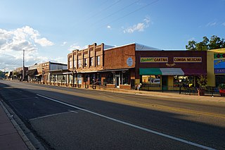
Fayetteville is a city and the county seat of Lincoln County, Tennessee, United States. The population was 6,994 at the 2000 census, and 6,827 at the 2010 census. A census estimate from 2018 showed 7,017.

<span class="mw-page-title-main">De Kalb, Texas</span> City in Texas, United States

De Kalb is a city in Bowie County, Texas, United States; it is part of the Texarkana metropolitan statistical area. Its two area codes are 430 and 903. Its ZIP code is 75559. It is in the Central Time Zone, and its population was 1,527 at the 2020 United States census.

<span class="mw-page-title-main">Rusk, Texas</span> City in Cherokee County, Texas

Rusk is a city and the county seat of Cherokee County in the U.S. state of Texas. At the 2020 United States census, it had a population of 5,285.

<span class="mw-page-title-main">Clarendon, Texas</span> City in Texas, United States

Clarendon is a city in Donley County, Texas, United States. Its population was 2,026 at the 2010 census. The county seat of Donley County, Clarendon is located on U.S. Highway 287 in the Texas Panhandle, 60 miles (97 km) east of Amarillo.

<span class="mw-page-title-main">Gruver, Texas</span> City in Texas, United States

Gruver is a city in Hansford County, Texas, United States. The population was 1,130 at the 2020 census. Farwell, in the center of Hansford County, approximately three miles east of what became Gruver, was established in 1880 by the Canott family of Illinois, and was the first town in the county. Gruver was established shortly after, and Farwell rapidly fell into oblivion after 1889, when it lost a county seat election to Hansford.

<span class="mw-page-title-main">Athens, Texas</span> City in Texas, United States

Athens is a city and the county seat of Henderson County, Texas, in the United States. As of the 2020 census, the city population was 12,857. The city has called itself the "Black-Eyed Pea Capital of the World." Athens was selected as one of the first "Certified Retirement Communities" in Texas. Athens was incorporated in 1856 and was named after Athens, the capital of Greece.

<span class="mw-page-title-main">Cactus, Texas</span> City in Texas, United States

Cactus is a city in Moore County, Texas, United States, located along U.S. Route 287. The population was 3,179 at the 2010 census.

<span class="mw-page-title-main">Henderson, Texas</span> City in Texas, United States

Henderson is a city and the county seat of Rusk County, Texas, in Northeast Texas, United States. Its population was 13,271 at the 2020 census. Henderson is named for James Pinckney Henderson, the first governor of Texas.

<span class="mw-page-title-main">New London, Texas</span> City in Texas, United States

New London is a city in Rusk County, Texas, United States. The population was 958 at the 2020 census.

<span class="mw-page-title-main">Hughes Springs, Texas</span> City in Texas, United States

Hughes Springs is a city in Cass and Morris counties in the U.S. state of Texas. At the 2020 census, its population was 1,575. The town was heavily damaged by an EF2 tornado on November 4, 2022.

<span class="mw-page-title-main">Reklaw, Texas</span> City in Texas, United States

Reklaw is a city in Cherokee and Rusk counties in the U.S. state of Texas. The population was 379 at the 2010 census.

<span class="mw-page-title-main">Tatum, Texas</span> City in Texas

Tatum is a city in Panola and Rusk Counties in the U.S. state of Texas. Its population was 1,342 at the 2020 census.

<span class="mw-page-title-main">Overton, Texas</span> City in Texas, United States

Overton is a city in Rusk and Smith counties in the U.S. state of Texas. Overton lies in two counties as well as two metropolitan areas. The Rusk County portion of the city is part of the Longview Metropolitan Statistical Area, while the Smith County portion is part of the Tyler Metropolitan Statistical Area.

References

  1. "2019 U.S. Gazetteer Files". United States Census Bureau. Retrieved August 7, 2020.
  2. 1 2 U.S. Geological Survey Geographic Names Information System: Cushing, Texas
  3. 1 2 "Population and Housing Unit Estimates". United States Census Bureau. May 24, 2020. Retrieved May 27, 2020.
  4. 1 2 "U.S. Census website". United States Census Bureau . Retrieved January 31, 2008.
  5. "US Gazetteer files: 2010, 2000, and 1990". United States Census Bureau. February 12, 2011. Retrieved April 23, 2011.
  6. "Census of Population and Housing". Census.gov. Retrieved June 4, 2015.
  7. 2010 general profile of population and housing characteriticis from the US census for Cushing
  8. Texas Event Report: EF2 Tornado (Report). National Centers for Environmental Information. 2022. Retrieved December 3, 2022.{{cite report}}: Unknown parameter |agency= ignored (help) Texas Event Report: EF2 Tornado (Report). National Centers for Environmental Information. 2022. Retrieved December 3, 2022.{{cite report}}: Unknown parameter |agency= ignored (help) Texas Event Report: EF2 Tornado (Report). National Centers for Environmental Information. 2022. Retrieved December 3, 2022.{{cite report}}: Unknown parameter |agency= ignored (help)
  9. Climate Summary for Cushing, Texas