Cyclone Batsirai

Last updated

Map key
  Tropical depression (≤38 mph, ≤62 km/h)
  Tropical storm (39–73 mph, 63–118 km/h)
  Category 1 (74–95 mph, 119–153 km/h)
  Category 2 (96–110 mph, 154–177 km/h)
  Category 3 (111–129 mph, 178–208 km/h)
  Category 4 (130–156 mph, 209–251 km/h)
  Category 5 (≥157 mph, ≥252 km/h)
  Unknown
Storm type
Disc Plain black.svg Tropical cyclone
Solid black.svg Subtropical cyclone
ArrowUp.svg Extratropical cyclone, remnant low, tropical disturbance, or monsoon depression

The origins of Cyclone Batsirai can be traced back to 23 January, when the Australian Bureau of Meteorology (BoM) reported that a tropical low had formed outside of the Australian region, well to the northwest of the Cocos Islands. [8] The Météo-France La Réunion (MFR) [nb 1] took note of the low, [10] along with the Joint Typhoon Warning Center (JTWC) [nb 2] which designated the low as Invest 96S. The disturbance was located within a marginally favourable environment for further development, with high levels of vertical wind shear, being offset by warm sea surface temperatures of around 29–30 °C (84–86 °F), therefore the agency gave a low chance for potential tropical cyclogenesis within the next 24 hours. [12] A day later at 00:30 UTC, the agency upgraded the probability to medium after the system gradually improved its convective pattern. [13] Later at 21:30 UTC the same day, the agency issued a Tropical Cyclone Formation Alert (TCFA) for Invest 96S, after noting its obscure low-level circulation center. [14] By 25 January, the low briefly entered the Australian region, before exiting by the next day, when the MFR upgraded the low to tropical disturbance status. [15] [16] [17] According to them, the system's convection had shown signs of gradual organization since 24 January. The center had become better defined with low-level clouds converging towards it in a defined circular pattern, suggesting that a closed circulation had formed. [17] The MFR further upgraded it to a tropical depression at 12:00 UTC the same day, as it continued to improve its convective structure along its low-level center. [18] After its convective activity was briefly interrupted after 18:00 UTC due to dry air, [19] The JTWC subsequently initiated advisories on the system and classified it as Tropical Cyclone 08S at 03:00 UTC the next day. [20]

Cyclone Batsirai near its initial peak intensity on 27 January Batsirai 2022-01-27 1000Z.jpg
Cyclone Batsirai near its initial peak intensity on 27 January

Three hours later, the MFR reported that the system had become a moderate tropical storm, and the Mauritius Meteorological Services named it Batsirai. [nb 3] [nb 4] [21] [22] Between 06:00 UTC and 12:00 UTC, Batsirai underwent rapid deepening and intensified from a moderate tropical storm to an intense tropical cyclone within a span of three hours. According to the MFR, it was favoured by the very small size of the system and its fast movement. It had also established an inner core 75 to 90 km (45 to 55 mi) in diameter. [23] Two hours later, the JTWC also upgraded it to a Category 2 tropical cyclone on the Saffir–Simpson scale, as it developed a small eye at about 7 nmi (13 km; 8.1 mi) in diameter. [24] However, by 18:00 UTC, it started to rapidly decline after its eye quickly collapsed and the cloud tops had warmed. Because of these reasons, the MFR downgraded it to a tropical cyclone. [25] At midnight of 28 January, it was further downgraded to a moderate tropical storm, after further weakening of the convective structure. [26] Three hours later, the JTWC downgraded it back to a tropical storm status. [27]

Batsirai resumed its intensification after being upgraded to a severe tropical storm at 06:00 UTC the next day. [28] Nine hours later, the JTWC upgraded it to a Category 1 tropical cyclone. [29] At 03:00 UTC on 30 January, the JTWC further upgraded it to a Category 2 tropical cyclone after noting a well-defined central dense overcast and a microwave eye feature. [30] The MFR further upgraded it to tropical cyclone status at midday. [31] Three hours later, the JTWC upgraded it to a Category 3 tropical cyclone, as its eyewall had expanded and also developed a 5 nmi (9.3 km; 5.8 mi) wide pinhole-eye. [32] However, this was short-lived, and it weakened to Category 1 status by 03:00 UTC on 1 February, as its pinhole-shaped eye collapsed and its eyewall became disorganized, possibly due to the influence of increasing vertical wind shear. [33] [34] At 15:00 UTC the same day, however, it re - strengthened to Category 2 status, as it managed to consolidate and its eye feature re-appeared on satellite imagery. [35] Three hours later, the MFR upgraded it to an intense tropical cyclone. [36]

By 03:00 UTC on 2 February, the cyclone underwent another round of rapid intensification, intensifying from a Category 2 to a Category 4 tropical cyclone. [37] Its eyewall rapidly organized and also developed a 15 nmi (28 km; 17 mi) wide eye. [37] After reaching its peak at 12:00 UTC, satellite imagery depicted the formation of another eyewall and signs of weakening. [38] [39] It weakened to a Category 3 system during this time. After completing the eyewall replacement cycle, the storm again briefly intensified into a Category 4 system, with MFR determining that Batsirai's central barometric pressure had rapidly fallen to 934 hPa (mbar; 27.58 inHg). [40] It weakened again to a Category 3 system, though it still maintained its overall convective structure. [41] [42]

Gradually weakening due to land interaction with Madagascar, it made landfall at 17:30 UTC on 5 February close to the city of Nosy Varika. MFR declared that Batsirai had degenerated into an overland depression, with the JTWC downgrading it to a tropical storm. [43] [44] The system entered into the Mozambique Channel, and the MFR re-upgraded the system to a moderate tropical storm. [45] By 7 February, it weakened into a remnant low before transitioning into a post-tropical cyclone. [46] [47] Despite fluctuating convective activity, high wind shear, and low sea surface temperatures, due to baroclinic forces, the MFR upgraded the system to a moderate tropical storm once more. [48] It then underwent subtropical transition according to the JTWC, with the agency ceasing advisories on the system on 15:00 UTC of 8 February. MFR issued their last advisory on the storm on 8 February as it again transitioned into a post-tropical cyclone, [49] with the system being last noted on 11 February. [50]

Preparations

Cyclone Batsirai rapidly intensifying on 2 February Batsirai 2022-02-02 0250Z-1415Z.gif
Cyclone Batsirai rapidly intensifying on 2 February

Mauritius

A class IV cyclone warning was issued on 2 February as Batsirai neared the island. [51]

Madagascar

The landfall area of Batsirai was projected to accumulate up to 250 to 500 mm (10 to 20 in) of rainfall. [52] The country's capital, Antananarivo, was predicted to have 150 millimetres (6 in) of rainfall. [2] Search and Rescue teams were deployed in Brickaville, Manakara, and Morondava. The START Network set aside $567,000 to provide assistance. Emergency stock lists were updated by HCT members to help restock humanitarian items. The country's government's disaster management agency worked with UNOSAT as well, and aerial assistance was also prepared as Batsirai approached. [53] Extensive flooding in the east, southeast, and central highlands and major damage were anticipated. The storm was also expected to cause more damage than usual due to the deforestation the country experienced in the last 20 years. [54] The third largest city in the nation, Antsirabe, was forecasted to receive in excess of 250 millimetres (10 in) of rainfall. [55]

Batsirai was expected to worsen food scarcities and emergencies in the country. Schools were closed on 4 February, and residents in low-lying and coastal areas were advised to leave. [56] The storm was also feared to hamper the relief effects of Tropical Storm Ana weeks before. [57] A predicted 4.4 million people were expected to be affected by the storm across 14 districts, with 595,000 directly. More than 150,000 inhabitants were expected be displaced. The IFRC launched a fundraiser to help with potential victims of the storm. [58] [59] [60]

Waves of up to 15 m (49 ft) were forecasted as the storm closed in on the coast. The United Nations worked with aid agencies to help with preparedness and the aftermath. Humanitarian items were stockpiled, and rescue aircraft were put on standby. A spokesman for the UN's organization OCHA, stated the impact of Batsirai was expected to be "considerable". [61] [62]

Impact

Cyclone Batsirai shortly before landfall in Madagascar on 5 February Batsirai 2022-02-05 1026Z.jpg
Cyclone Batsirai shortly before landfall in Madagascar on 5 February

Mauritius

Along with the airport, all transport services were closed due to the impact. Wind gusts reached 155 km/h (96 mph), [63] and rain totalled 180 mm (7 in) in other areas of the island country. Two deaths were reported. [3] [64] Trees had been uprooted in many areas, and at least 7,500 homes faced power outages. [65] A total of 138 people sought refuge in evacuation centers. [66] The Mahébourg waterfront was damaged by large waves, with several chairs and tables swept into the sea. [67]

Réunion

At least 36,000 people on the island lost power as Batsirai approached, [68] with 10,000 still out on 7 February. [69] Several people were injured, with the storm causing carbon monoxide poisoning in 10 people. [70] Eleven sailors were stranded in an oil tanker during the storm, and were rescued on 4 February. [71] Agricultural losses were estimated at €47 million ($53.3 million). [nb 5] [72]

Madagascar

Communication was sparse initially when the storm made landfall. Batsirai's conditions caused power outages and forced many people to move into shelters. Trees fell and power grids were knocked out, as well as homes were destroyed. [73] At least 112,000 people [5] were displaced by the storm, with 91,000 left homeless. [74] Several houses had their roofs completely blown away, and many large coconut palm trees were blown over. Some houses were reduced to just wooden frames, and a survivor said the damage resembled a "fire", and that it was the "strongest cyclone [anyone] had experienced". Mananjary and Manakara were particularly heavy hit, with the former having at least 26,000 displaced alone, and had its hospital and prison damaged as well. [75] A large portion of Madagascar was still waterlogged from Ana weeks earlier, and the arrival of Batsirai worsened the effects. [76] [69]

Nosy Varika was strongly damaged. An official described the damage as if they were "bombed", with 95% of buildings being reported as destroyed. Floods cut access to the town. Electric poles fell, and roofs were torn off in the city of Fianarantsoa, which was also heavily flooded. A landslide was caused by the cyclone in the region of Haute Matsiatra. [77] Flooding and debris rendered 17 bridges and 17 roads impassable, as well as at least 69 classrooms completely destroyed, and 439 damaged; this left over 9,000 children unable to attend lessons, [78] with 403 in Mananjary alone. [79] After the storm passed, already flooded canals and rivers continued to rise. [80] In Mananjary and surrounding areas, early reports indicated over 6,000 buildings were flooded, with half of them destroyed. [69] The president of Madagascar, Andry Rajoelina, showed images of a church's metal roof twisted off, along other damage online after he visited Mananjary. Fruit trees and rice paddies were ripped and flooded in the town and other areas, hampering the harvest that was only two weeks away. [81] The time it took to travel to the town by car was increased several days due to damage. Main roads linking the capital to smaller areas were cut off, making relief efforts even harder. [75] [78]

The UNHAS aerial flight discovered that Fitovinany region mostly suffered flooding damage; with several communities taking heavy hits to their agriculture and infrastructure. [78] In total, over 17,100 homes were damaged, with 7,488 destroyed, 2,714 partially, and 6,978 flooded. 53 health centers were damaged, along with 6 destroyed. [82] In Ikongo alone, 87 people died. [6] Collapsing homes killed people in their sleep. [5] A member of parliament representing the district also said that people also drowned in flooded areas there as well. [83]

121 deaths were reported, [5] [4] [84] including 13 children, with 5 being under 12 years of age. [85] [82]

Aftermath

The amount of destruction is significant and for many this is only the beginning. The storm may have passed, but now the affected communities must restart from scratch—rebuilding their homes, schools and hospitals

Vincent Dolanneau, Humanity & Inclusion's director for Madagascar, to ABC News. [86]

Mauritius

A total of 454 people, in 182 affected families, sought shelter in 45 centers. They were all surveyed in order to give them the necessary help after the storm. The Minister of Social Integration, Social Security, and National Solidarity, Mrs. Fazila Jeewa-Daureeawoo, made the announcement about the procedure on 7 February. [87]

Madagascar

False-color satellite imagery of flooding in Madagascar on 10 February Cyclone Batsirai Floods Madagascar on 10 February 2022.jpg
False-color satellite imagery of flooding in Madagascar on 10 February

The impacts of Tropical Storm Ana were compounded by the damage that Batsirai brought. [88]

Schools and churches prepared to shelter those displaced around Mananjary. [77] World Food Programme distributed hot meals to 4,000 evacuated and displaced people in shelters. [89] Drinking water and basic necessities were lacking in impacted areas, and the spreading of several diseases was also a concern. [90] A humanitarian crisis was also feared to rise out of the storm's effects. [91] Aerial rescue effort first took place on 6 February via an UNHAS flight. The Malagasy government provided households affected with monetary donations. UNICEF also supported relief efforts by giving out kits to create child-friendly spaces in several regions of the country. Other measures were taken to help decrease incidents inside of shelters as well. [88] A team that initially consisted of five EU Civil Protection officials from France, Finland, and Sweden traveled to affected areas to help victims of the storm. [92]

The PRIOI had deployed 87 tons of humanitarian material from its warehouses in the country to use for relief efforts, an effort that cost approximately €667,000. [93] An estimated 75,000 people—including 37,500 children—were in need of relief assistance after Batsirai. [85] WASH partners delivered items to Vatovavy, Fitovinany, and Atsimo Atisinanana regions. [82]

International response

France and Germany have offered water purification modules via the EU Civil Protection Mechanism. [92]

See also

Notes

  1. Météo-France's meteorological office in Réunion (MFR) is the official Regional Specialized Meteorological Center for the South-West Indian Ocean, tracking all tropical cyclones south of the equator, from the east coast of Africa to 90° E. [9]
  2. The Joint Typhoon Warning Center is a joint United States Navy – United States Air Force task force that issues tropical cyclone warnings for the Indian Ocean and other regions. [11]
  3. The name Batsirai was provided by Zimbabwe to be used for the sequential naming list for the cyclone season.
  4. The Sub-Regional Tropical Cyclone Advisory Center (Mauritius Meteorological Services) in Mauritius names a storm if the system intensifies into a moderate tropical storm between 55° E and 90° E. [9]
  5. All monetary figures are in their 2022 values unless otherwise noted.

Related Research Articles

<span class="mw-page-title-main">2010–11 South-West Indian Ocean cyclone season</span> Cyclone season in the Southwest Indian Ocean

The 2010–11 South-West Indian Ocean cyclone season was the least active cyclone season on record in the basin, tied with 1982–83, producing only three systems of gale intensity. This was due to cooler than normal water temperatures and the Walker circulation – a broad atmospheric circulation – causing unusually moist conditions in the eastern Indian Ocean and unusually dry conditions in the western Indian Ocean. The basin includes the waters of the ocean south of the equator and west of 90º E to the eastern coast of Africa.

<span class="mw-page-title-main">Tropical Storm Cyprien</span> South-West Indian tropical storm in 2001 and 2002

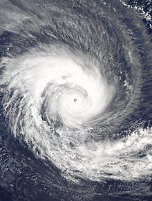
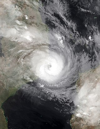
Severe Tropical Storm Cyprien was a short-lived tropical cyclone that caused minor damage in Madagascar. Forming on December 30, 2001, Cyprien quickly strengthened in a slightly favorable environment. By January 2, the storm attained its peak intensity with winds of 100 km/h (65 mph) according to Météo-France and 95 km/h (60 mph) according to the Joint Typhoon Warning Center. Later that day the storm made landfall in Morombe, at a weaker intensity, and dissipated early on January 3. Throughout the affected areas, Cyprien destroyed 957 structures, leaving 1.16 billion Malagasy franc in damages. No fatalities were reported; however two people were listed as missing.

<span class="mw-page-title-main">2012–13 South-West Indian Ocean cyclone season</span> Cyclone season in the Southwest Indian Ocean

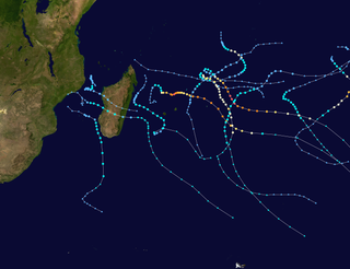
The 2012–13 South-West Indian Ocean cyclone season was a slightly above average event in tropical cyclone formation in the Southern hemisphere tropical cyclone year starting on July 1, 2012, and ending on June 30, 2013. Within this basin, tropical and subtropical disturbances are officially monitored by the Regional Specialised Meteorological Centre on Réunion island, while the Mauritius and Madagascar weather services assign names to significant tropical and subtropical disturbances. The first tropical disturbance of the season developed on October 12 and rapidly developed into the earliest known intense tropical cyclone on record during October 14.

<span class="mw-page-title-main">2014–15 South-West Indian Ocean cyclone season</span> Cyclone season in the Southwest Indian Ocean

The 2014–15 South-West Indian Ocean cyclone season was an above average event in tropical cyclone formation. It began on November 15, 2014, and ended on April 30, 2015, with the exception for Mauritius and the Seychelles, for which it ended on May 15, 2015. These dates conventionally delimit the period of each year when most tropical and subtropical cyclones form in the basin, which is west of 90°E and south of the Equator. Tropical and subtropical cyclones in this basin are monitored by the Regional Specialised Meteorological Centre in Réunion.

<span class="mw-page-title-main">Tropical Storm Delfina</span> South-West Indian tropical storm in 2002 and 2003

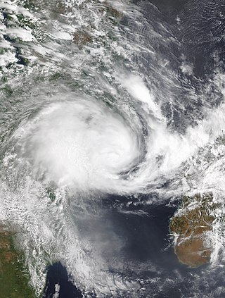
Severe Tropical Storm Delfina was a damaging tropical cyclone that affected southeastern Africa in January 2003. The fourth named storm of the 2002–03 South-West Indian Ocean cyclone season, Delfina formed off the northwest coast of Madagascar on December 30, 2002. It quickly intensified while moving westward, becoming a strong tropical storm before hitting northeastern Mozambique on December 31. Delfina weakened while moving inland, and it was no longer classifiable as a tropical cyclone by January 1, 2003. However, its remnants moved across the country and into Malawi, later looping around and crossing back over Mozambique; the remnants of Delfina were last observed on January 9.

<span class="mw-page-title-main">Cyclone Firinga</span> South-West Indian tropical cyclone in 1989

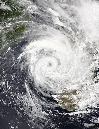
Tropical Cyclone Firinga produced record-breaking rainfall on the French overseas department of Réunion. It was the sixth named storm of the season, having developed on January 24, 1989 in the south-west Indian Ocean. Given the name Firinga, it moved generally southwestward for much of its duration. While the cyclone was approaching Mauritius late on January 28, it attained peak winds of 135 km/h (85 mph). Firinga passed 50 km (31 mi) west of the island, producing 190 km/h (120 mph) wind gusts that destroyed 844 homes. Heavy crop damage occurred on the island, and damage nationwide was estimated at $60 million (1989 USD). One person was killed in Mauritius.

<span class="mw-page-title-main">2016–17 South-West Indian Ocean cyclone season</span> Cyclone season in the Southwest Indian Ocean

The 2016–17 South-West Indian Ocean cyclone season was a below-average season, with five tropical storms, three of which intensified into tropical cyclones. It officially began on November 15, 2016, and ended on April 30, 2017, with the exception for Mauritius and the Seychelles, for which it ended on May 15, 2017. These dates conventionally delimit the period of each year when most tropical and subtropical cyclones form in the basin, which is west of 90°E and south of the Equator. Tropical and subtropical cyclones in this basin were monitored by the Regional Specialised Meteorological Centre in Réunion, though the Joint Typhoon Warning Center issued unofficial advisories.

<span class="mw-page-title-main">2021 Pacific typhoon season</span> Typhoon season in the Western Pacific Ocean

The 2021 Pacific typhoon season was the second consecutive to have below-average tropical cyclone activity, with twenty-two named storms, and was the least active since 2011. Nine became typhoons, and five of those intensified into super typhoons. This low activity was caused by a strong La Niña that had persisted from the previous year. The season's first named storm, Dujuan, developed on February 16, while the last named storm, Rai, dissipated on December 21. The season's first typhoon, Surigae, reached typhoon status on April 16. It became the first super typhoon of the year on the next day, also becoming the strongest tropical cyclone in 2021. Surigae was also the most powerful tropical cyclone on record in the Northern Hemisphere for the month of April. Typhoons In-fa and Rai are responsible for more than half of the total damage this season, adding up to a combined total of $2.02 billion.

<span class="mw-page-title-main">2019–20 South-West Indian Ocean cyclone season</span> Cyclone season in the Southwest Indian Ocean

The 2019–20 South-West Indian Ocean cyclone season was a slightly above-average season in tropical cyclone and subtropical cyclone formation west of 90°E. The season officially began on 15 November, however, the formation of the first system—Zone of Disturbed Weather 01—occurred on 22 July 2019, well before the official start of the season. This was the earliest start to a season since the 2016–17 season. The season then officially ended on 30 April 2020, with the exception of Mauritius and the Seychelles, for which it officially ended on 15 May 2020. These dates conventionally delimit the period of each year when most tropical and subtropical cyclones form in the basin, which is west of 90°E and south of the Equator. Tropical and subtropical cyclones in this basin are monitored by the Regional Specialized Meteorological Centre in Réunion.

<span class="mw-page-title-main">2020–21 South-West Indian Ocean cyclone season</span> Cyclone season in the Southwest Indian Ocean

The 2020–21 South-West Indian Ocean cyclone season was an above-average season which produced 12 named storms, with 7 strengthening into tropical cyclones. The season started with the formation of Cyclone Alicia in the extreme northeast section of the basin on 12 November 2020, just before the official start of the season, which marked the third season in a row in which a tropical cyclone formed before the official start of the season. It officially began on 15 November 2020, and ended with the dissipation of Cyclone Jobo on 24 April, 6 days before the official end on 30 April 2021, with the exception of Mauritius and the Seychelles, which officially ended on 15 May 2021. These dates conventionally delimit the period of each year when most tropical and subtropical cyclones form in the basin, which is west of 90°E and south of the Equator. Tropical and subtropical cyclones in this basin are monitored by the Regional Specialised Meteorological Centre in Réunion and unofficially by the Joint Typhoon Warning Center.

<span class="mw-page-title-main">Tropical Storm Eliakim</span> South-West Indian Ocean severe tropical storm in 2018

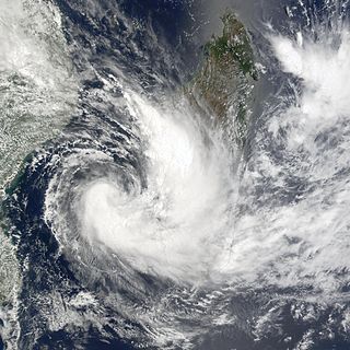
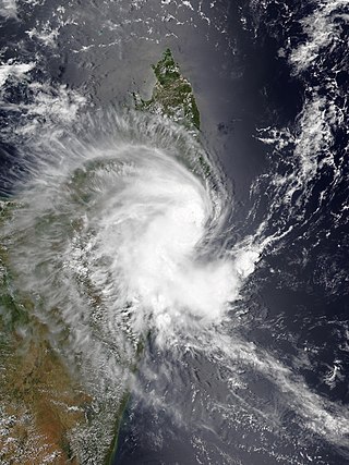
Severe Tropical Storm Eliakim was a tropical cyclone that affected Madagascar and killed 21 people in 2018. The seventh tropical depression, sixth tropical storm of the 2017–18 South-West Indian Ocean cyclone season, and fourth tropical cyclone in 2018 to impact Madagascar, Eliakim was first noted as an area of atmospheric convection south-southwest of Diego Garcia on 9 March. Developmental conditions were favorable in its vicinity, and on 14 March, both the Joint Typhoon Warning Center (JTWC) and Météo-France La Réunion (MFR) began issuing warnings on the system, with MFR designating it as Tropical Disturbance 7 and the JTWC giving it the designation 14S. On the next day, MFR upgraded the system to a moderate tropical storm, assigning it the name Eliakim. Eliakim further intensified into a severe tropical storm on 15 March, with the JTWC upgrading it to a Category 1-equivalent cyclone on the Saffir–Simpson scale on 16 March. Eliakim made landfall on Masoala at 07:00 UTC, after which MFR estimated maximum 10-minute sustained winds of 110 km/h (70 mph) within the system. Eliakim weakened into a moderate tropical storm before abruptly turning southwards and re-emerging over water on 17 March. Despite unfavorable conditions, Eliakim re-intensified into a severe tropical storm on 19 March before being downgraded back into a moderate tropical storm 6 hours later. Eliakim transitioned into a post-tropical cyclone on 20 March as it moved away from Madagascar, with the MFR last tracking the system on 22 March.

<span class="mw-page-title-main">2021–22 South-West Indian Ocean cyclone season</span> Cyclone season in the Southwest Indian Ocean

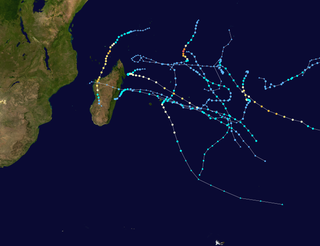
The 2021–22 South-West Indian Ocean cyclone season featured the record latest start for the first system to develop. Despite the late start, it was an above-average season that produced 12 named storms, with 5 becoming tropical cyclones. The season began on 15 November 2021, and ended on 30 April 2022, with the exception for Mauritius and the Seychelles, for which it ended on 15 May 2022. These dates conventionally delimit the period of each year when most tropical and subtropical cyclones form in the basin, which is west of 90°E and south of the Equator. However, tropical cyclones that form at any time between 1 July 2021 and 30 June 2022 will count towards the season total. Tropical and subtropical cyclones in this basin are monitored by the Regional Specialised Meteorological Centre in Réunion and unofficially by the Joint Typhoon Warning Center.

<span class="mw-page-title-main">Cyclone Felleng</span> South-West Indian tropical cyclone in 2013

Intense Tropical Cyclone Felleng was a powerful tropical cyclone that caused destruction across Seychelles, Madagascar, and Réunion. The seventh Tropical Disturbance, sixth named storm, and the third Intense Tropical Cyclone of the 2012–13 South-West Indian Ocean cyclone season, Felleng originated from an area of atmospheric convection embedded in the Intertropical Convergence Zone.

<span class="mw-page-title-main">Tropical Storm Ana (2022)</span> South-West Indian Ocean tropical storm in 2022.

Severe Tropical Storm Ana was a deadly tropical cyclone that affected the African nations of Madagascar, Malawi and Mozambique and was the third-deadliest tropical cyclone in 2022, after the Western Pacific Tropical Storm Megi and Atlantic Hurricane Ian. The first named storm of the 2021–22 South-West Indian Ocean cyclone season, Ana developed from an area of convection that was designated as Invest 93S northeast of Madagascar.

<span class="mw-page-title-main">Cyclone Emnati</span> South-West Indian Ocean tropical cyclone in 2022.

Intense Tropical Cyclone Emnati was a tropical cyclone that affected Madagascar, only two weeks after Cyclone Batsirai. The sixth tropical disturbance, the second tropical cyclone, and the second intense tropical cyclone of the 2021–22 South-West Indian Ocean cyclone season, Emnati formed from a zone of disturbed weather that was first noted on 15 February 2022. It continued westward, and steadily intensified before getting named Emnati a day later. Due to present dry air and wind shear, the storm had struggled to intensify significantly, and it became a category 1-equivalent on the Saffir-Simpson Scale later. After it managed to close off its core from prohibiting factors, the storm quickly intensified into a category 4-equivalent days later, forming a small eye around its CDO. Emnati then underwent a lengthy eyewall replacement cycle, which strongly weakened the storm as it moved closer to Madagascar. Eventually, it weakened back to a category 1-equivalent cyclone before making landfall in the country.

<span class="mw-page-title-main">Tropical Storm Dumako</span> South-West Indian Ocean tropical storm in 2022.

Moderate Tropical Storm Dumako was a weak tropical cyclone that caused moderate damage in Madagascar. The fourth disturbance and fourth named storm of the 2021–22 South-West Indian Ocean cyclone season, it was the third storm to make landfall on Madagascar in 2022 after Ana and Batsirai.

<span class="mw-page-title-main">Cyclone Gombe</span> South-West Indian Ocean cyclone in 2022

Tropical Cyclone Gombe was a strong tropical cyclone that affected Mozambique. It became the first storm to make a major landfall in Nampula Province in Mozambique since Cyclone Jokwe in 2008. The eighth tropical storm, fourth tropical cyclone and fourth intense tropical cyclone of the 2021–22 South-West Indian Ocean cyclone season, Gombe originated from a tropical disturbance located off the coast of Madagascar. This area of convection was designated by the Joint Typhoon Warning Center as Invest 97S on 6 March. The next day, it began to slowly move westward and executed a loop as it became more organized, which prompted Météo-France Reunion (MFR) to note the system as Zone of Disturbed Weather 09. The system became a depression on 9 March, and became a moderate tropical storm the same day. Soon after being named, Gombe made landfall in Madagascar, and entered in the Mozambique Channel the next day. The storm continued its westward motion while slowly intensifying, and was upgraded to a Tropical Cyclone by the MFR on 10 March. Closing in on Nampula Province, the storm underwent rapid intensification, and was upgraded to the fourth Intense Tropical Cyclone of the year and reached its peak intensity on 11 march, with maximum 10-minute sustained winds of 165 km/h (105 mph), maximum 1-minute sustained winds of 185 km/h (115 mph), and a minimum central pressure of 960 hectopascals (28 inHg). The storm proceeded to make landfall, and quickly lost its convection over land. On 12 March, Gombe degenerated into a remnant low overland. However, the system subsequently turned southeastward and reemerged over water, before briefly regenerating into a tropical depression on 17 March. Gombe dissipated later that day.

<span class="mw-page-title-main">2022–23 South-West Indian Ocean cyclone season</span> Tropical cyclone season

The 2022–23 South-West Indian Ocean cyclone season was one of the deadliest South-West Indian cyclone seasons on record, mostly due to Cyclone Freddy. It officially began on 15 November 2022, and ended on 30 April 2023, with the exception for Mauritius and the Seychelles, for which it ended on 15 May 2023. These dates conventionally delimit the period of each year when most tropical and subtropical cyclones form in the basin, which is west of 90°E and south of the Equator. However, tropical cyclones can form year-round, and all tropical cyclones that form between 1 July 2022 and 30 June 2023 will be part of the season. Tropical and subtropical cyclones in this basin are monitored by the Regional Specialised Meteorological Centre in Réunion and unofficially by the Joint Typhoon Warning Center.

<span class="mw-page-title-main">Cyclone Cheneso</span> South-West Indian Ocean cyclone in 2023

Tropical Cyclone Cheneso was a strong tropical cyclone that affected Madagascar in January 2023. The fourth tropical storm and fifth tropical cyclone of the 2022–23 South-West Indian Ocean cyclone season, Cheneso developed out of a zone of disturbed weather status which was first monitored at RSMC La Réunion on 17 January. Despite convection wrapping into the curved band pattern, the system formed into a tropical depression on 18 January. The depression strengthened into Severe Tropical Storm Cheneso on the following day. Cheneso made landfall over northern Madagascar and weakened into an inland depression, before emerging into the Mozambique Channel. Cheneso later strengthened into a tropical cyclone on 25 January. The system continued moving southeast, before transitioning into a post–tropical depression on 29 January.

<span class="mw-page-title-main">Meteorological history of Cyclone Freddy</span>

Cyclone Freddy was the longest-lived tropical cyclone on record, beating the previous record of Hurricane John in 1994. It also has the highest accumulated cyclone energy (ACE) of any tropical cyclone on record worldwide, surpassing Hurricane Ioke in 2006. Additionally, Freddy is the only known tropical cyclone to achieve seven separate rapid intensification cycles. While in the Australian region cyclone basin, the storm quickly intensified and became a Category 4 severe tropical cyclone, before it moved into the South-West Indian Ocean basin. The Joint Typhoon Warning Center (JTWC) estimated Freddy's peak strength, equivalent to Category 5 strength on the Saffir–Simpson scale. The Météo-France (MFR) upgraded it to a very intense tropical cyclone. Freddy made its first landfall near Mananjary, Madagascar. Freddy rapidly weakened overland but re-strengthened in the Mozambique Channel. Soon afterward, Freddy made its second landfall just south of Vilankulos, Mozambique.

References

  1. Cappucci, Matthew (7 February 2022). "Cyclone Batsirai slams Madagascar at major hurricane strength, killing 20". Washington Post. ISSN   0190-8286. Archived from the original on 8 February 2022. Retrieved 8 February 2022.
  2. 1 2 Pedram Javaheri (2 February 2022). "Rapidly intensified Cyclone Batsirai bears down on Madagascar, weeks after deadly floods". CNN. Archived from the original on 2 February 2022. Retrieved 2 February 2022.
  3. 1 2 ion (3 February 2022). "Batsirai fait deux victimes" [Batsirai kills two]. ionnews.mu (in French). Archived from the original on 3 February 2022. Retrieved 3 February 2022.
  4. 1 2 Richard Davies, Africa, News (14 February 2022). "Madagascar – Death Toll From Tropical Cyclone Batsirai Rises to 121". Flood List. Archived from the original on 14 February 2022. Retrieved 14 February 2022.{{cite web}}: CS1 maint: bot: original URL status unknown (link) CS1 maint: multiple names: authors list (link)
  5. 1 2 3 4 Bezain, Laetitia (9 February 2022). "Madagascar's death toll from Cyclone Batsirai rises to 92". KXAN Austin. Associated Press. Archived from the original on 9 February 2022. Retrieved 9 February 2022.
  6. 1 2 Rabary, Lovasoa (11 February 2022). "Death toll from Cyclone Batsirai in Madagascar jumps to 120 - state agency". Reuters. Archived from the original on 12 February 2022. Retrieved 11 February 2022.
  7. GlobalCatastrophe Recap First Half of 2021 (PDF) (Report). Aon Benfield. 12 April 2022. Retrieved 12 April 2022.
  8. "Tropical Cyclone Outlook for the Western Region Issued at 2:00 pm WST on Sunday 23 January 2022 for the period until midnight WST Wednesday 26 January 2022". Australian Bureau of Meteorology. 23 January 2022. Archived from the original on 17 January 2022. Retrieved 23 January 2022.{{cite web}}: CS1 maint: bot: original URL status unknown (link)
  9. 1 2 Regional Association I Tropical Cyclone Committee (2021). "Tropical Cyclone Operational Plan for the South-West Indian Ocean" (PDF). World Meteorological Organization. Archived from the original on 20 February 2022. Retrieved 14 February 2022. Alt URL
  10. Bulletin for Cyclonic Activity and Significant Tropical Weather in the Southwest Indian Ocean (PDF) (Report). Météo-France. 23 January 2022. Retrieved 20 July 2023.
  11. Frequently Asked Questions (Report). Joint Typhoon Warning Center. 13 August 2012. Archived from the original on 4 October 2013. Retrieved 22 September 2012.
  12. Significant Tropical Weather Advisory for the Indian Ocean Reissued (Report). United States Joint Typhoon Warning Center. 23 January 2022. Archived from the original on 23 January 2022. Retrieved 29 January 2022. Alt URL
  13. Significant Tropical Weather Advisory for the Indian Ocean Reissued (Report). United States Joint Typhoon Warning Center. 24 January 2022. Archived from the original on 24 January 2022. Retrieved 29 January 2022. Alt URL
  14. Tropical Cyclone Formation Alert (Invest 96S) (Report). United States Joint Typhoon Warning Center. 24 January 2022. Archived from the original on 24 January 2022. Retrieved 29 January 2022. Alt URL
  15. "Tropical Cyclone Outlook for the Western Region Issued at 2:39 pm WST on Tuesday 25 January 2022 for the period until midnight WST Friday 28 January 2022". Australian Bureau of Meteorology. 25 January 2022. Archived from the original on 31 January 2022. Retrieved 26 January 2022.{{cite web}}: CS1 maint: bot: original URL status unknown (link)
  16. "Tropical Cyclone Outlook for the Western Region issued at 2:00 pm WST on Wednesday 26 January 2022". Australian Bureau of Meteorology. 26 January 2022. Archived from the original on 15 April 2023. Retrieved 20 July 2023.{{cite web}}: CS1 maint: bot: original URL status unknown (link)
  17. 1 2 "Tropical Disturbance 2 Warning Number 1/2/20212022" (PDF). La Réunion, France: Météo-France. 26 January 2022. Archived (PDF) from the original on 27 January 2022. Retrieved 29 January 2022.
  18. "Tropical Depression 2 Warning Number 2/2/20212022" (PDF). La Réunion, France: Météo-France. 26 January 2022. Archived (PDF) from the original on 28 January 2022. Retrieved 29 January 2022.
  19. "Tropical Depression 2 Warning Number 3/2/20212022" (PDF). La Réunion, France: Météo-France. 26 January 2022. Archived (PDF) from the original on 29 January 2022. Retrieved 29 January 2022.
  20. Prognostic Reasoning for Tropical Cyclone 08S (Eight) Warning No. 1 (Report). United States Joint Typhoon Warning Center. 27 January 2022. Archived from the original on 27 January 2022. Retrieved 29 January 2022. Alt URL
  21. "Moderate Tropical Storm 2 (Batsirai) Warning Number 5/2/20212022" (PDF). La Réunion, France: Météo-France. 27 January 2022. Archived (PDF) from the original on 27 January 2022. Retrieved 29 January 2022.
  22. "Current Storm/Cyclone Moderate Tropical Storm Batsirai 27 January 2022". Mauritius Meteorological Services. 27 January 2022. Archived from the original on 13 February 2022. Retrieved 27 January 2022.{{cite web}}: CS1 maint: bot: original URL status unknown (link)
  23. "*CORRECTED* Intense Tropical Cyclone 2 (Batsirai) Warning Number 6/2/20212022" (PDF). La Réunion, France: Météo-France. 27 January 2022. Archived (PDF) from the original on 27 January 2022. Retrieved 29 January 2022.
  24. Prognostic Reasoning for Tropical Cyclone 08S (Batsirai) Warning No. 2 (Report). United States Joint Typhoon Warning Center. 27 January 2022. Archived from the original on 27 January 2022. Retrieved 29 January 2022. Alt URL
  25. "Tropical Cyclone 2 (Batsirai) Warning Number 7/2/20212022" (PDF). La Réunion, France: Météo-France. 27 January 2022. Archived (PDF) from the original on 27 January 2022. Retrieved 29 January 2022.
  26. "Moderate Tropical Storm 2 (Batsirai) Warning Number 8/2/20212022" (PDF). La Réunion, France: Météo-France. 28 January 2022. Archived (PDF) from the original on 28 January 2022. Retrieved 29 January 2022.
  27. Prognostic Reasoning for Tropical Cyclone 08S (Batsirai) Warning No. 3 (Report). United States Joint Typhoon Warning Center. 28 January 2022. Archived from the original on 28 January 2022. Retrieved 29 January 2022. Alt URL
  28. "Severe Tropical Storm 2 (Batsirai) Warning Number 13/2/20212022" (PDF). La Réunion, France: Météo-France. 29 January 2022. Archived (PDF) from the original on 31 January 2022. Retrieved 31 January 2022.
  29. Prognostic Reasoning for Tropical Cyclone 08S (Batsirai) Warning No. 6 (Report). United States Joint Typhoon Warning Center. 29 January 2022. Archived from the original on 31 January 2022. Retrieved 31 January 2022. Alt URL
  30. Prognostic Reasoning for Tropical Cyclone 08S (Batsirai) Warning No. 7 (Report). United States Joint Typhoon Warning Center. 30 January 2022. Archived from the original on 31 January 2022. Retrieved 31 January 2022. Alt URL
  31. "Tropical Cyclone 2 (Batsirai) Warning Number 18/2/20212022" (PDF). La Réunion, France: Météo-France. 30 January 2022. Archived (PDF) from the original on 31 January 2022. Retrieved 31 January 2022.
  32. Prognostic Reasoning for Tropical Cyclone 08S (Batsirai) Warning No. 8 (Report). United States Joint Typhoon Warning Center. 30 January 2022. Archived from the original on 31 January 2022. Retrieved 31 January 2022. Alt URL
  33. Prognostic Reasoning for Tropical Cyclone 08S (Batsirai) Warning No. 10 (Report). United States Joint Typhoon Warning Center. 31 January 2022. Archived from the original on 31 January 2022. Retrieved 3 February 2022. Alt URL
  34. Prognostic Reasoning for Tropical Cyclone 08S (Batsirai) Warning No. 11 (Report). United States Joint Typhoon Warning Center. 31 January 2022. Archived from the original on 31 January 2022. Retrieved 3 February 2022. Alt URL
  35. Prognostic Reasoning for Tropical Cyclone 08S (Batsirai) Warning No. 12 (Report). United States Joint Typhoon Warning Center. 1 February 2022. Archived from the original on 1 February 2022. Retrieved 3 February 2022. Alt URL
  36. "Intense Tropical Cyclone 2 (Batsirai) Warning Number 27/2/20212022" (PDF). La Réunion, France: Météo-France. 1 February 2022. Archived (PDF) from the original on 3 February 2022. Retrieved 3 February 2022.
  37. 1 2 Prognostic Reasoning for Tropical Cyclone 08S (Batsirai) Warning No. 13 (Report). United States Joint Typhoon Warning Center. 1 February 2022. Archived from the original on 1 February 2022. Retrieved 3 February 2022. Alt URL
  38. Prognostic Reasoning for Tropical Cyclone 08S (Batsirai) Warning No. 14 (Report). United States Joint Typhoon Warning Center. 2 February 2022. Archived from the original on 2 February 2022. Retrieved 3 February 2022. Alt URL
  39. "Intense Tropical Cyclone 2 (Batsirai) Warning Number 27/2/20212022" (PDF). La Réunion, France: Météo-France. 2 February 2022. Archived (PDF) from the original on 2 February 2022. Retrieved 3 February 2022.
  40. Prognostic Reasoning for Tropical Cyclone 08S (Batsirai) Warning No. 16 (Report). United States Joint Typhoon Warning Center. 3 February 2022. Retrieved 3 February 2022.[ dead link ] Alt URL
  41. Prognostic Reasoning for Tropical Cyclone 08S (Batsirai) Warning No. 20 (Report). United States Joint Typhoon Warning Center. 5 February 2022. Retrieved 5 February 2022.[ dead link ] Alt URL
  42. "Intense Tropical Cyclone 2 (Batsirai) Warning Number 38/2/20212022" (PDF). La Réunion, France: Météo-France. 2 February 2022. Archived (PDF) from the original on 4 February 2022. Retrieved 4 February 2022.
  43. Prognostic Reasoning for Tropical Cyclone 08S (Batsirai) Warning No. 21 (Report). United States Joint Typhoon Warning Center. 6 February 2022. Retrieved 6 February 2022.[ dead link ] Alt URL
  44. "Overland Depression 2 (Batsirai) Warning Number 44/2/20212022" (PDF). La Réunion, France: Météo-France. 6 February 2022. Archived (PDF) from the original on 6 February 2022. Retrieved 6 February 2022.
  45. "Moderate Tropical Storm 2 (Batsirai) Warning Number 47/2/20212022" (PDF). La Réunion, France: Météo-France. 6 February 2022. Archived (PDF) from the original on 6 February 2022. Retrieved 6 February 2022.
  46. "Remnant low 2 (Batsirai) Warning Number 49/2/20212022" (PDF). La Réunion, France: Météo-France. 6 February 2022. Archived (PDF) from the original on 6 February 2022. Retrieved 7 February 2022.
  47. "Post tropical depression 2 (Ex-Batsirai) Warning Number 50/2/20212022" (PDF). La Réunion, France: Météo-France. 6 February 2022. Archived (PDF) from the original on 12 February 2022. Retrieved 7 February 2022.
  48. "Moderate Tropical Storm Batsirai 2 (Batsirai) Warning Number 51/2/20212022" (PDF). La Réunion, France: Météo-France. 6 February 2022. Archived (PDF) from the original on 12 February 2022. Retrieved 7 February 2022.
  49. "Post Tropical Depression Batsirai 2 (Batsirai) Warning Number 54/2/20212022" (PDF). La Réunion, France: Météo-France. 8 February 2022. Archived (PDF) from the original on 12 February 2022. Retrieved 8 February 2022.
  50. "Bulletin for Cyclonic Activity and Significant Tropical Weather in the Southwestern Indian Ocean" (PDF). La Réunion, France: Météo-France. 11 February 2022. Archived (PDF) from the original on 12 February 2022. Retrieved 11 February 2022.
  51. Par La Rédaction (2 February 2022). "Un avertissement de cyclone de classe 4 est en vigueur à Maurice" [A class 4 cyclone warning is in effect in Mauritius]. L'Express (in French). Archived from the original on 2 February 2022. Retrieved 3 February 2022.
  52. "Cyclone Batsirai hits Madagascar". public.wmo.int. 4 February 2022. Retrieved 8 February 2022.
  53. "SOUTHERN AFRICA: Cyclone Season Flash Update No. 1" (PDF). United Nations Office for the Coordination of Humanitarian Affairs : 3. Archived from the original (PDF) on 3 February 2022.
  54. "Bracing for Batsirai". NASA Earth Observatory. 4 February 2022. Archived from the original on 5 February 2022. Retrieved 5 February 2022.
  55. Masters, Jeff (3 February 2022). "Category 4 Tropical Cyclone Batsirai headed for vulnerable Madagascar » Yale Climate Connections". Yale Climate Connections. Archived from the original on 3 February 2022. Retrieved 3 February 2022.
  56. Livingston, Ian (3 February 2022). "Powerful tropical cyclone Batsirai to hit Madagascar on Saturday". The Washington Post. Archived from the original on 4 February 2022. Retrieved 4 February 2022.
  57. "Threat to lives and livelihoods as Cyclone Batsirai hurls towards Madagascar - Madagascar". ReliefWeb. 4 February 2022. Archived from the original on 4 February 2022. Retrieved 4 February 2022.
  58. "Madagascar: Tropical storm and cyclone | IFRC". www.ifrc.org. Archived from the original on 4 February 2022. Retrieved 4 February 2022.
  59. "Madagascar: More than 4 million people at risk as Tropical Cyclone Batsirai bears down on eastern coast | IFRC". www.ifrc.org. 4 February 2022. Archived from the original on 4 February 2022. Retrieved 4 February 2022.
  60. "Storm Batsirai set to displace 150,000 in Madagascar, aid agencies say". WTVB | 1590 AM · 95.5 FM | The Voice of Branch County. 4 February 2022. Archived from the original on 4 February 2022. Retrieved 4 February 2022.
  61. "Cyclone Batsirai approaches Madagascar, poses 'serious threat'". www.news24.com. Archived from the original on 5 February 2022. Retrieved 5 February 2022.
  62. Farge, Emma (4 February 2022). "Storm Batsirai set to displace 150,000 in Madagascar, aid agencies say". Reuters. Archived from the original on 5 February 2022. Retrieved 5 February 2022.
  63. Par La Rédaction (3 February 2022). "Batsirai: aucun avertissement de cyclone n'est en vigueur à Maurice" [Batsirai: no cyclone warning is in effect in Mauritius]. L'Express (in French). Archived from the original on 3 February 2022. Retrieved 3 February 2022.
  64. Bhuckory, Kamlesh; Bonorchis, Renee (2 February 2022). "Cyclone Dumps Heavy Rains on Mauritius En Route to Madagascar". bloomberg.com. Archived from the original on 2 February 2022. Retrieved 2 February 2022.
  65. "Thousands without power as cyclone winds hit Mauritius". ARY NEWS. 2 February 2022. Archived from the original on 2 February 2022. Retrieved 2 February 2022.
  66. Lepoigneur, Florian (2 February 2022). "Batsirai: pas de gros dégâts selon le Premier ministre" [Batsirai: no major damage according to the Prime Minister]. L'Express (in French). Archived from the original on 2 February 2022. Retrieved 3 February 2022.
  67. Par La Rédaction (2 February 2022). "Le Mahébourg Waterfront face aux coups de boutoir de Batsirai" [The Mahébourg Waterfront faced with batsirai's battering]. L'Express (in French). Archived from the original on 3 February 2022. Retrieved 3 February 2022.
  68. "36 000 clients privés d'électricité" [36,000 customers without electricity]. Journal de l'île de La Réunion (in French). 2 February 2022. Archived from the original on 3 February 2022. Retrieved 3 February 2022.
  69. 1 2 3 Duff, Renee; AccuWeather meteorologist (6 February 2022). "Batsirai delivers 2nd devastating blow in as many weeks to vulnerable Madagascar". AccuWeather . Archived from the original on 7 February 2022. Retrieved 6 February 2022.
  70. "Residents of Reunion Island confined to homes as tropical cyclone Batsirai passes through". France 24. 3 February 2022. Archived from the original on 3 February 2022. Retrieved 3 February 2022.
  71. "Sailors stranded off France's La Reunion by Cyclone Batsirai saved". France 24. 4 February 2022. Archived from the original on 4 February 2022. Retrieved 4 February 2022.
  72. "Batsirai : 47 millions de pertes agricoles" [Batsirai: 47 million agricultural losses]. Le Quotidien de la Réunion (in French). Archived from the original on 12 February 2022. Retrieved 11 February 2022.
  73. Rabary, Lovasoa (5 February 2022). "Cyclone Batsirai destroys homes and knocks out power in Madagascar". Reuters. Archived from the original on 6 February 2022. Retrieved 6 February 2022.
  74. WION Video Team (10 February 2022). "Madagascar struggles as death toll from Cyclone Batsirai nears 100". WION. Archived from the original on 10 February 2022. Retrieved 10 February 2022.
  75. 1 2 Chutel, Lynsey (8 February 2022). "Cyclone Batsirai Leaves Devastation and Death in Madagascar". The New York Times. ISSN   0362-4331. Archived from the original on 8 February 2022. Retrieved 8 February 2022.
  76. "An estimated 45,000 people have been displaced by a cyclone in Madagascar". NPR. Associated Press. 6 February 2022. Archived from the original on 6 February 2022. Retrieved 6 February 2022.
  77. 1 2 Rabary, Lovasoa (6 February 2022). "Cyclone kills at least 10 in Madagascar, destroying homes and cutting power". Reuters. Archived from the original on 6 February 2022. Retrieved 6 February 2022.
  78. 1 2 3 "Southern Africa: Cyclone Season Flash Update No. 4 (Tropical Cyclone Batsirai) (8 February 2022) - Madagascar". ReliefWeb. Archived from the original on 8 February 2022. Retrieved 8 February 2022.
  79. MAP Action, ReliefWeb (8 February 2022). "Madagascar: Tropical Cyclone Batisirai, Damaged and Destroyed Classrooms at District level (As of 8th Feb 2022)" (PDF). ReliefWeb . 1: 1. Archived (PDF) from the original on 12 February 2022. Retrieved 10 February 2022.
  80. Rabary, Lovasoa (7 February 2022). "Hit by second cyclone in two weeks, Madagascar struggles to bring relief". Reuters. Archived from the original on 7 February 2022. Retrieved 7 February 2022.
  81. Antananarivo, Reuters in (9 February 2022). "Madagascar death toll from Cyclone Batsirai rises to 92". the Guardian. Archived from the original on 12 February 2022. Retrieved 9 February 2022.{{cite web}}: |first= has generic name (help)
  82. 1 2 3 Relief Web, Situation Report (10 February 2022). "Southern Africa: Cyclone Season Flash Update No. 5 (Tropical Cyclone Batsirai) (10 February 2022)". ReliefWeb. Archived from the original on 12 February 2022. Retrieved 10 February 2022.
  83. "Madagascar death toll from Cyclone Batsirai rises to 80 -state agency". WTVB | 1590 AM · 95.5 FM | The Voice of Branch County. Archived from the original on 12 February 2022. Retrieved 9 February 2022.
  84. "Southern Africa: Cyclone Season Flash Update No. 6 (Tropical Cyclone Batsirai) (13 February 2022) - Madagascar". ReliefWeb. 15 February 2022. Archived from the original on 15 February 2022. Retrieved 15 February 2022.
  85. 1 2 "UNICEF working to assist tens of thousands following cyclone Batsirai In Madagascar". www.unicef.org. Archived from the original on 9 February 2022. Retrieved 9 February 2022.
  86. Winsor, Morgan. "Cyclone Batsirai leaves over a dozen dead, thousands homeless in Madagascar". US: ABC News. Archived from the original on 7 February 2022. Retrieved 7 February 2022.
  87. "Mauritius: Cyclone Batsirai - Minister Jeewa-Daureeawoo Announces Support Measures for Affected Vulnerable Families". allAfrica.com. 8 February 2022. Archived from the original on 9 February 2022. Retrieved 9 February 2022.
  88. 1 2 ReliefWeb, OCHA (7 February 2022). "SOUTHERN AFRICA: Cyclone Season Flash Update No. 3: Tropical Cyclone Batsirai" (PDF). Flash Update. Archived from the original (PDF) on 8 February 2022.
  89. "Madagascar: WFP provides immediate emergency assistance in the aftermath of cyclone Batsirai - Madagascar". ReliefWeb. Archived from the original on 7 February 2022. Retrieved 7 February 2022.
  90. "Cyclone Batsirai: Madagascar dealt a second devastating blow in two weeks - CNN Video". CNN. 7 February 2022. Archived from the original on 7 February 2022. Retrieved 7 February 2022.
  91. "Humanitarian crisis feared as cyclone kills 20 in Madagascar". France 24. 7 February 2022. Archived from the original on 7 February 2022. Retrieved 7 February 2022.
  92. 1 2 "Madagascar: EU provides assistance to people affected by devastating cyclone Batsirai - Madagascar". ReliefWeb. Archived from the original on 8 February 2022. Retrieved 7 February 2022.
  93. Par La Rédaction (9 February 2022). "Batsirai à Madagascar : la Croix-Rouge française déploie 87 tonnes de matériel d'urgence" [Batsirai in Madagascar: the French Red Cross deploys 87 tons of emergency equipment]. Le Quotidien de la Réunion (in French). Archived from the original on 9 February 2022. Retrieved 9 February 2022.
Intense Tropical Cyclone Batsirai
Batsirai 2022-02-02 0956Z.jpg
Cyclone Batsirai near peak intensity northwest of Mauritius on 2 February.