
Cape Verde is a group of arid Atlantic islands which are home to distinct communities of plants, birds, and reptiles. The islands constitute the unique Cape Verde Islands dry forests ecoregion, according to the World Wildlife Fund.
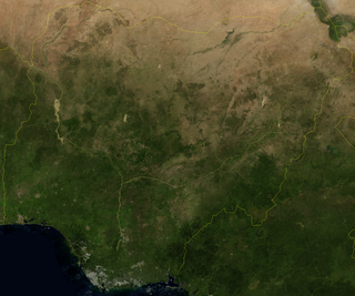
Nigeria is a country in West Africa. It shares land borders with the Republic of Benin to the west, Chad and Cameroon to the east, and Niger to the north. Its coast lies on the Gulf of Guinea in the south and it borders Lake Chad to the northeast. Notable geographical features in Nigeria include the Adamawa Plateau, Mambilla Plateau, Jos Plateau, Obudu Plateau, the Niger River, Benue River, and Niger Delta.

A monsoon is traditionally a seasonal reversing wind accompanied by corresponding changes in precipitation but is now used to describe seasonal changes in atmospheric circulation and precipitation associated with annual latitudinal oscillation of the Intertropical Convergence Zone (ITCZ) between its limits to the north and south of the equator. Usually, the term monsoon is used to refer to the rainy phase of a seasonally changing pattern, although technically there is also a dry phase. The term is also sometimes used to describe locally heavy but short-term rains.
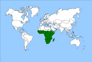
The Afrotropical realm is one of the Earth's eight biogeographic realms. It includes Sub-Saharan Africa, the southern Arabian Peninsula, the island of Madagascar, and the islands of the western Indian Ocean. It was formerly known as the Ethiopian Zone or Ethiopian Region.

A rain shadow is an area of significantly reduced rainfall behind a mountainous region, on the side facing away from prevailing winds, known as its leeward side.

The trade winds or easterlies are permanent east-to-west prevailing winds that flow in the Earth's equatorial region. The trade winds blow mainly from the northeast in the Northern Hemisphere and from the southeast in the Southern Hemisphere, strengthening during the winter and when the Arctic oscillation is in its warm phase. Trade winds have been used by captains of sailing ships to cross the world's oceans for centuries. They enabled European colonization of the Americas, and trade routes to become established across the Atlantic Ocean and the Pacific Ocean.

The wet season is the time of year when most of a region's average annual rainfall occurs. Generally, the season lasts at least one month. The term green season is also sometimes used as a euphemism by tourist authorities. Areas with wet seasons are dispersed across portions of the tropics and subtropics.
In West Africa, the forest zone refers to the southern part of the region once covered by tropical rainforest. Sometimes this region is referred to as Guinea to distinguish it from the grassland-covered Sudan, drier Sahel and per-arid Sahara. It is made-up of vegetation having mainly trees and consist of the following local biotic communities: -mangrove swamp forest -tropical rain forest.

In physical geography and physical geology, aspect is the compass direction or azimuth that a terrain surface faces.

The Upper Guinean forests is a tropical seasonal forest region of West Africa. The Upper Guinean forests extend from Guinea and Sierra Leone in the west through Liberia, Côte d'Ivoire and Ghana to Togo in the east, and a few hundred kilometers inland from the Atlantic coast. A few enclaves of montane forest lie further inland in the mountains of central Guinea and central Togo and Benin.

Forest–savanna mosaic is a transitory ecotone between the tropical moist broadleaf forests of Equatorial Africa and the drier savannas and open woodlands to the north and south of the forest belt. The forest–savanna mosaic consists of drier forests, often gallery forest, interspersed with savannas and open grasslands.
A tropical marine climate is a tropical climate that is primarily influenced by the ocean. It is usually experienced by islands and coastal areas 10° to 20° north and south of the equator. There are two main seasons in a tropical marine climate: the wet season and the dry season. The annual rainfall is 1000 to over 1500 mm. The temperature ranges from 20 °C to 35 °C. Under the Köppen climate classification, a "tropical marine climate" would fall under Af or Am, tropical rainforest or tropical monsoon climate. The trade winds blow all year round and are moist, as they pass over warm seas. These climatic conditions are found, for example, across the Caribbean, the eastern coasts of Brazil, Madagascar and Queensland; and many islands in tropical waters.

The wildlife of Togo is composed of the flora and fauna of Togo, a country in West Africa. Despite its small size the country has a diversity of habitats; there are only remnants of the once more extensive rain forests in the south, there is Sudanian savanna in the north-western part of the country and larger areas of Guinean forest–savanna mosaic in the centre and north-east. The climate is tropical with distinct wet and dry seasons. There are estimated to be over 3000 species of vascular plants in the country, and 196 species of mammals and 676 species of birds have been recorded there.

The North American monsoon, variously known as the Southwest monsoon, the Mexican monsoon, the New Mexican monsoon, or the Arizona monsoon is a pattern of pronounced increase in thunderstorms and rainfall over large areas of the southwestern United States and northwestern Mexico, centered roughly on the Rio Grande Valley, and typically occurring between June and mid-September. During the monsoon, thunderstorms are fueled by daytime heating and build up during the late afternoon and early evening. Typically, these storms dissipate by late night, and the next day starts out fair, with the cycle repeating daily. The monsoon typically loses its energy by mid-September when much drier conditions are reestablished over the region. Geographically, the North American monsoon precipitation region is centered over the Sierra Madre Occidental in the Mexican states of Sinaloa, Durango, Sonora and Chihuahua.

Rain is water droplets that have condensed from atmospheric water vapor and then fall under gravity. Rain is a major component of the water cycle and is responsible for depositing most of the fresh water on the Earth. It provides water for hydroelectric power plants, crop irrigation, and suitable conditions for many types of ecosystems.
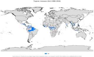
An area of tropical monsoon climate is a tropical climate sub-type that corresponds to the Köppen climate classification category Am. Tropical monsoon climates have monthly mean temperatures above 18 °C (64 °F) in every month of the year and a dry season. The tropical monsoon climate is the intermediate climate between the wet Af and the drier Aw.

Earth rainfall climatology Is the study of rainfall, a sub-field of meteorology. Formally, a wider study includes water falling as ice crystals, i.e. hail, sleet, snow. The aim of rainfall climatology is to measure, understand and predict rain distribution across different regions of planet Earth, a factor of air pressure, humidity, topography, cloud type and raindrop size, via direct measurement and remote sensing data acquisition. Current technologies accurately predict rainfall 3–4 days in advance using numerical weather prediction. Geostationary orbiting satellites gather IR and visual wavelength data to measure realtime localised rainfall by estimating cloud albedo, water content, and the corresponding probability of rain.

Seasonal tropical forest, also known as moist deciduous, semi-evergreen seasonal, tropical mixed or monsoon forest, typically contains a range of tree species: only some of which drop some or all of their leaves during the dry season. This tropical forest is classified under the Walter system as (i) tropical climate with high overall rainfall and (ii) having a very distinct wet season with dry season. These forests represent a range of habitats influenced by monsoon (Am) or tropical wet savannah (Aw/As) climates. Drier forests in the Aw climate zone are typically deciduous and placed in the Tropical dry forest biome: with further transitional zones (ecotones) of savannah woodland then tropical and subtropical grasslands, savannas, and shrublands.
The Guineo-Congolian region is a biogeographical region in Africa straddling the Equator and stretching from the Atlantic Ocean through the Congo Basin to the Congo / Nile divide in Rwanda and Burundi. Formerly, this region was largely covered in rain forest, on both well-drained sites and in swamp forests, but little undisturbed primary forest now remains, having been replaced in many areas by savanna and secondary-growth forest.

Rainforests and vine thickets are a major vegetation group in Australia. It consists of temperate to tropical rainforests, monsoon forests, and vine thickets. Rainforests and vine thickets are generally found in small pockets across the eastern and northern portions of the continent, including western Tasmania, eastern New South Wales, eastern Queensland, the northern portion of the Northern Territory, and the Kimberley Region of northeastern Western Australia.