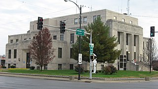
Jefferson County is a county located in the southern part of the U.S. state of Illinois. According to the 2020 census, it has a population of 37,113. The county seat is Mount Vernon.

Hancock County is a county in the U.S. state of Illinois. According to the 2020 census, it has a population of 17,620. Its county seat is Carthage, and its largest city is Hamilton. The county is made up of rural towns with many farmers.
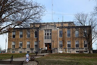
Hamilton County is a county located in the U.S. state of Illinois. At the 2020 census, its population was 7,993. Its county seat is McLeansboro. It is located in the southern portion of the state known locally as "Little Egypt".
Wood Dale is a city in Addison Township, DuPage County, Illinois, United States. Per the 2020 census, the population was 14,012.

Oswego is a village in Kendall and Will Counties, Illinois, United States. Per the 2020 census, the population was 34,485. Oswego is the largest municipality in Kendall County. It is a suburb of Chicago, Illinois.

Eskdale is an unincorporated community in western Millard County, Utah, United States, just east of the Nevada border.

Twigg Township is one of twelve townships in Hamilton County, Illinois, USA. As of the 2010 census, its population was 132 and it contained 71 housing units.
Alden, elevation 1,004 feet, is an unincorporated community and census-designated place in McHenry County, Illinois, United States. It was named a CDP prior to the 2020 census which showed a population of 113.
Duncan Mills is an unincorporated community in Fulton County, Illinois, United States. Duncan Mills is located at the junction of US 24, US 136, and IL 100 south of Lewistown.
Dudleyville is an unincorporated community in Bond County, Illinois, United States. Dudleyville is south of Greenville and near Greenville Airport.
Dayton is an unincorporated community in Colona Township, Henry County, Illinois, United States.
Dorsey is an unincorporated community in Madison County, Illinois, United States. Dorsey is located in Moro Township, 6 miles (9.7 km) north-northeast of Bethalto. Dorsey has a post office with ZIP code 62021.
Alexander is an unincorporated community in Morgan County, Illinois, United States. Alexander is 10 miles (16 km) east of Jacksonville and has a post office with ZIP code 62601.
Dorans is an unincorporated community in Coles County, Illinois, United States. Dorans is located on U.S. Route 45, 5 miles (8.0 km) north-northeast of Mattoon.
Alta is an unincorporated community on the northwest border of Peoria in Peoria County, Illinois, United States. Alta is 8 miles (13 km) north-northwest of downtown Peoria. The decommissioned Illinois State Route 174 runs through Alta, and the Rock Island Trail begins in Alta.
Edgington is an unincorporated community in Rock Island County, Illinois, United States. Edgington is located on Illinois Route 192, 4 miles (6.4 km) southwest of Andalusia.
Aden is an unincorporated community in Hamilton County, Illinois, United States. Aden is 6 miles (9.7 km) west of Mill Shoals.
Delafield is an unincorporated community in Dahlgren Township, Hamilton County, Illinois, United States. Delafield is located on Illinois Route 142, 5.5 miles (8.9 km) northwest of McLeansboro.
Dressor is an unincorporated community in Ramsey Township, Fayette County, Illinois, United States. Dressor is 3.7 miles (6.0 km) northeast of Ramsey.
Danway is an unincorporated community in Miller Township, LaSalle County, Illinois, United States. Danway is 9.9 miles (15.9 km) northeast of Ottawa.


