Daly City station

Last updated

Daly City
Two trains at Daly City station, July 2023.jpg
Two trains at Daly City station in July 2023
General information
Location500 John Daly Boulevard
Daly City, California
Coordinates 37°42′22″N122°28′08″W / 37.706224°N 122.468934°W / 37.706224; -122.468934
Owned by San Francisco Bay Area Rapid Transit District
Line(s) BART M-Line
Platforms1 side platform, 1 island platform
Tracks3
Connections
Construction
Structure typeElevated
Parking2,068 spaces
Bicycle facilities20 lockers
AccessibleYes
ArchitectGerald McCue & Associates [1]
History
OpenedNovember 5, 1973 (1973-11-05)
Passengers
20244,871 (weekday average) [2]
Services
Preceding station Bart compact logo.svg Bay Area Rapid Transit Following station
Terminus Blue Line Balboa Park
Green Line Balboa Park
Colma
toward Millbrae
Red Line Balboa Park
toward Richmond
Colma Yellow Line Balboa Park
Location
Daly City station

Daly City station is an elevated Bay Area Rapid Transit (BART) station in Daly City, California, just south of the city limits of San Francisco. It is adjacent to Interstate 280 and California Route 1, which it serves as a park-and-ride station. The station is served by the Red, Yellow, Green, and Blue lines; it is the west terminal for the Green and Blue lines.

Contents

Station layout

Muni route 14R bus in the east busway Muni route 14R bus at Daly City station, June 2018.JPG
Muni route 14R bus in the east busway

The station has three tracks with an island platform between the east tracks and a side platform next to the west track. The side platform is used primarily by southbound trains continuing to terminals on the Peninsula. The island platform is used primarily by northbound trains on the east track and by southbound trains terminating at the station (to return northbound) on the center track.

Daly City station is served by a number of SamTrans and Muni bus routes. Most routes use the Niantic Avenue busway on the east side of the station; Muni route 54 and the shuttle routes stop on the west side of the station. [3] [4]

San Francisco State University operates the free Daly City BART Express Shuttle, stopping on the west side of the station. Its Campus Loop shuttle also serves Daly City station on a limited number of trips. Seton Medical Center and Skyline College also operate free shuttles to the station. [3] [4]

History

San Mateo County pulled out of plans for the BART system in 1961. However, BART retained plans for a station at the north edge of Daly City, just over the county line from San Francisco, because it was expected to draw significant revenue. The station would be paid for by taxes in other counties because of San Mateo County's withdrawal. [5] The BART Board approved the name "Daly City" in December 1965. [6]

Original plans approved by voters in 1962 called for an elevated station at Daly City. [5] BART later considered an underground station and rail yard at the site. In 1966, facing a budget deficit, BART relocated the yard to Hayward and reverted to plans for a less-expensive elevated station at Daly City. [7]

From its November 5, 1973 opening until the extension to Colma station in 1996, Daly City was the southern terminus of BART on the Peninsula and the only station that was not in one of the three base counties of San Francisco, Alameda and Contra Costa. [8] It still serves as the southern terminus for the Green and Blue lines, which do not continue to other San Mateo County stations.

Seismic retrofitting of the station and parking garage took place in 2008–2010. [9] [10] As of 2024, BART indicates "significant market, local support, and/or implementation barriers" that must be overcome to allow transit-oriented development on the surface parking lots at the station. Such development would not begin until at least the mid-2030s. [11]

Bus service

Daly City station's position as the terminus of BART on the peninsula led to connecting bus service. The station was initially served by local bus routes operated by the privately-owned Northgate Transit. [12] [13] Western Greyhound Lines, which operated commuter-oriented service from San Mateo County to downtown San Francisco, refused to add a Daly City station stop to its Pacifica-San Francisco route. [14] [15] Another private operator, ServiCar, operated two commuter routes between Peninsula points and the station from January 31 to February 27, 1974. [16] Muni began serving Daly City with route 91 in April 1975; other routes were gradually added, including the 28 in 1982 and the 14L (now 14R) in 2012. [17]

SamTrans was formed in 1976 as a publicly-owned consolidation of most of the existing private bus systems in San Mateo County. SamTrans began operating a Daly City–San Bruno–San Francisco International Airport bus route in July 1976, though Northgate continued to operate the Daly City-area local routes until they were taken over by SamTrans in early 1977. [18] [19] SamTrans also took over Greyhound commuter routes on July 2, 1977. The Pacifica buses were cut back to Daly City station during times that BART operated, and several local routes serving the airport and the El Camino Real corridor were redirected to terminate at the station as well. [20] [21] Golden Gate Transit operated a Daly City station–Golden Gate Bridge toll plaza connector route beginning in June 1981. [22]

Related Research Articles

<span class="mw-page-title-main">San Francisco Peninsula</span> Peninsula in the San Francisco Bay Area

The San Francisco Peninsula is a peninsula in the San Francisco Bay Area that separates San Francisco Bay from the Pacific Ocean. On its northern tip is the City and County of San Francisco. Its southern base is Los Altos, Mountain View, in Santa Clara County, south of Palo Alto and north of Sunnyvale and Los Altos. Most of the Peninsula is occupied by San Mateo County, between San Francisco and Santa Clara counties, and including the cities and towns of Atherton, Belmont, Brisbane, Burlingame, Colma, Daly City, East Palo Alto, El Granada, Foster City, Hillsborough, Half Moon Bay, La Honda, Loma Mar, Los Altos, Menlo Park, Millbrae, Mountain View, Pacifica, Palo Alto, Pescadero, Portola Valley, Redwood City, San Bruno, San Carlos, San Mateo, South San Francisco, and Woodside.

<span class="mw-page-title-main">AC Transit</span> Public transit operator in Alameda County and Contra Costa County, California

AC Transit is an Oakland-based public transit agency serving the western portions of Alameda and Contra Costa counties in the East Bay of the San Francisco Bay Area. AC Transit also operates "Transbay" routes across San Francisco Bay to San Francisco and selected areas in San Mateo and Santa Clara counties. AC Transit is constituted as a special district under California law. It is governed by seven elected members. It is not a part of or under the control of Alameda or Contra Costa counties or any local jurisdictions.

<span class="mw-page-title-main">SamTrans</span> Public transit operator in San Mateo County, California

SamTrans is a public transport agency in and around San Mateo, California, in the San Francisco Bay Area. It provides bus service throughout San Mateo County and into portions of San Francisco and Palo Alto. SamTrans also operates commuter shuttles to BART stations and community shuttles. Service is largely concentrated on the east side of the Santa Cruz Mountains, and, in the central county, I-280, leaving coast-side service south of Pacifica spotty and intermittent.

<span class="mw-page-title-main">Embarcadero station</span> Subway station in San Francisco, California, US

Embarcadero station is a combined BART and Muni Metro rapid transit subway station in the Market Street subway in downtown San Francisco. Located under Market Street between Drumm Street and Beale Street near The Embarcadero, it serves the Financial District neighborhood and surrounding areas. The three-level station has a large fare mezzanine level, with separate platform levels for Muni Metro and BART below. Embarcadero station opened in May 1976 – almost two years after service began through the Transbay Tube – as an infill station.

<span class="mw-page-title-main">Montgomery Street station</span> Rapid transit station in San Francisco, California, US

Montgomery Street station is a combined BART and Muni Metro rapid transit subway station in the Market Street subway in downtown San Francisco. Located under Market Street between Montgomery Street and Sansome Street, it serves the Financial District neighborhood and surrounding areas. The three-level station has a large fare mezzanine level, with separate platform levels for Muni Metro and BART below. Montgomery Street and Embarcadero station to the north are typically the two busiest stations in the BART system.

<span class="mw-page-title-main">Civic Center/UN Plaza station</span> Rapid transit station in San Francisco, California, US

Civic Center/UN Plaza station is a combined BART and Muni Metro rapid transit station in the Market Street subway in downtown San Francisco. Located under Market Street between 7th Street and 8th Street, it is named for the Civic Center neighborhood and the adjacent United Nations Plaza. The three-level station has a large fare mezzanine level, with separate platform levels for Muni Metro and BART below.

<span class="mw-page-title-main">Red Line (BART)</span> Rapid Transit line in the San Francisco Bay Area, California

The Red Line is a Bay Area Rapid Transit (BART) line in the San Francisco Bay Area that runs between Richmond station and Millbrae station via San Francisco International Airport station. It has 24 stations in Richmond, El Cerrito, Berkeley, Oakland, San Francisco, Daly City, Colma, South San Francisco, San Bruno, and Millbrae. The line shares tracks with the four other mainline BART services.

<span class="mw-page-title-main">Yellow Line (BART)</span> Rapid transit line in the San Francisco Bay Area

The Yellow Line is a Bay Area Rapid Transit (BART) line in the San Francisco Bay Area that runs between Antioch and San Francisco International Airport (SFO). Some morning trains and all trains after 9 pm are extended from SFO to serve Millbrae station when the Red Line is not running. It serves 28 stations in Antioch, Pittsburg, Bay Point, Concord, Pleasant Hill, Walnut Creek, Lafayette, Orinda, Oakland, San Francisco, Daly City, Colma, South San Francisco, San Bruno, and Millbrae. It is the most-used BART line, and the only line with additional trains on weekdays.

<span class="mw-page-title-main">Blue Line (BART)</span> Rapid transit line in the San Francisco Bay Area

The Blue Line is a Bay Area Rapid Transit (BART) line in the San Francisco Bay Area that runs between Dublin/Pleasanton station and Daly City station. It has 18 stations in Dublin, Pleasanton, Castro Valley, San Leandro, Oakland, San Francisco, and Daly City.

<span class="mw-page-title-main">Balboa Park station</span> Transit station in San Francisco, California, US

Balboa Park station is a Bay Area Rapid Transit (BART) station and Muni Metro complex in the Mission Terrace neighborhood of San Francisco, California, located near the eponymous Balboa Park. It is an intermodal hub served by four BART routes, three Muni Metro lines, and a number of Muni bus routes. The station complex also includes two rail yards, Cameron Beach Yard and Green Light Rail Center, where Muni maintains Muni Metro trains and heritage streetcars. BART uses a below-grade island platform on the west side of the complex; Muni Metro routes use several smaller side platforms located on surface-level rail loops around the yards.

<span class="mw-page-title-main">Colma station</span> Rapid transit station in Colma, California, US

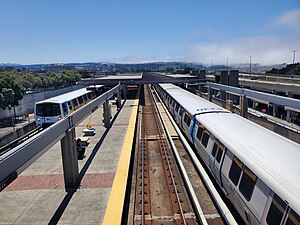
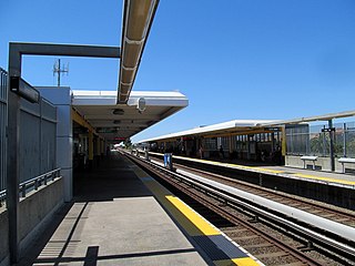
Colma station is a Bay Area Rapid Transit (BART) station located in unincorporated northern San Mateo County, California adjacent to the incorporated town of Colma and city of Daly City. The station is served by the Red and Yellow lines.

<span class="mw-page-title-main">Millbrae station</span> Train station in Millbrae, California, U.S.

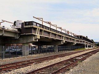
Millbrae station is an intermodal transit station serving Bay Area Rapid Transit (BART) and Caltrain, located in Millbrae, California. The station is the terminal station for BART on the San Francisco Peninsula, served by two lines: The Red Line before 9 pm and the Yellow Line during the early morning and evening. It is served by all Caltrain services. The station is also served by SamTrans bus service, Commute.org and Caltrain shuttle buses, and other shuttles.

<span class="mw-page-title-main">12th Street Oakland City Center station</span> Rapid transit station in Oakland, California, US

12th Street/Oakland City Center station is an underground Bay Area Rapid Transit (BART) station located under Broadway between 12th Street and 14th Street in Downtown Oakland, adjacent to the Oakland City Center. The station has three underground levels, with tracks on the second and third levels. It is served by the Red Line, Orange Line, and Yellow Line, as well as by AC Transit buses on the surface.

<span class="mw-page-title-main">19th Street Oakland station</span> Metro station in Oakland, California, US

19th Street Oakland station is an underground Bay Area Rapid Transit (BART) station located under Broadway between 17th Street and 20th Street in the Uptown District of Oakland, California. It is a timed transfer point between northbound trains to Richmond and to Antioch. The station has three underground levels, with tracks on the second and third levels. It is served by the Red Line, Orange Line, and Yellow Line, as well as by AC Transit buses on the surface at the Uptown Transit Center.

<span class="mw-page-title-main">Union City station</span> Metro station in Union City, California, US

Union City station is a Bay Area Rapid Transit (BART) station in Union City, California. The station sits near Decoto Road east of Alvarado-Niles Road, directly behind the James Logan High School campus. The station is served by the Orange and Green lines. Local bus service is provided by Union City Transit and AC Transit.

<span class="mw-page-title-main">Hayward station (BART)</span> Metro station in Hayward, California, US

Hayward station is a Bay Area Rapid Transit (BART) station in Hayward, California, serving Downtown Hayward and the surrounding areas. It is served by the Orange and Green lines. The elevated station has two side platforms. A two-lane bus terminal is located on the northeast side of the station. A pedestrian tunnel under the Union Pacific Railroad Oakland Subdivision connects the fare lobby to a parking lot and a five-level parking garage.

<span class="mw-page-title-main">Dumbarton Express</span> Bus service in the San Francisco Bay Area

Dumbarton Express is a regional public transit service in the San Francisco Bay Area connecting Alameda, San Mateo, and Santa Clara Counties via the Dumbarton Bridge, the system's namesake. The bus service is funded by a consortium of five transit agencies. Dumbarton Express is administered by AC Transit and operated under contract by MV Transportation.

<span class="mw-page-title-main">Transportation in the San Francisco Bay Area</span> Overview of transportation in the San Francisco Bay Area, California

People in the San Francisco Bay Area rely on a complex multimodal transportation infrastructure consisting of roads, bridges, highways, rail, tunnels, airports, seaports, and bike and pedestrian paths. The development, maintenance, and operation of these different modes of transportation are overseen by various agencies, including the California Department of Transportation (Caltrans), the Association of Bay Area Governments, San Francisco Municipal Transportation Agency, and the Metropolitan Transportation Commission. These and other organizations collectively manage several interstate highways and state routes, eight passenger rail networks, eight trans-bay bridges, transbay ferry service, local and transbay bus service, three international airports, and an extensive network of roads, tunnels, and bike paths.

<span class="mw-page-title-main">All Nighter (bus service)</span> San Francisco Bay Area late night bus service

The All Nighter is a night bus service network in the San Francisco Bay Area, California. Portions of the service shadow the rapid transit and commuter rail services of BART and Caltrain, which are the major rail services between San Francisco, the East Bay, the Peninsula, and San Jose. Neither BART nor Caltrain operate owl service due to overnight track maintenance; the All Nighter network helps fill in this service gap. The slogan is, "Now transit stays up as late as you do!"

References

  1. Cerny, Susan Dinkelspiel (2007). An Architectural Guidebook to San Francisco and the Bay Area (1st ed.). Layton, UT: Gibbs Smith. pp. 501–502. ISBN   978-1-58685-432-4. OCLC   85623396.
  2. "Monthly Ridership Reports". San Francisco Bay Area Rapid Transit District. February 2024.
  3. 1 2 "Daly City Station: Transit Stops" (PDF). Metropolitan Transportation Commission. January 12, 2018.
  4. 1 2 "Daly City Station: Schedules & Fares" (PDF). Metropolitan Transportation Commission. January 12, 2018.
  5. 1 2 Demoro, Harre W. (December 12, 1968). "BART Answers Daly City". Oakland Tribune. p. 46-F via Newspapers.com.
  6. "Names Approved for 38 Rapid Transit Stations Around Bay". Oakland Tribune. December 10, 1965. p. 10 via Newspapers.com.
  7. LaPierre, Frank (February 9, 1968). "BART, D.C. Feud On Aerial Design Problem". The Times. p. 51 via Newspapers.com.
  8. "BART Chronology January 1947 – March 2009" (PDF). San Francisco Bay Area Rapid Transit District. March 2009. Archived from the original (PDF) on October 13, 2013.
  9. "Earthquake Safety Program Construction Updates (archive)". San Francisco Bay Area Rapid Transit District. 2009.
  10. "Earthquake safety work at Daly City Station to affect fare gates" (Press release). San Francisco Bay Area Rapid Transit District. January 26, 2010.
  11. BART Transit-Oriented Development Program Work Plan: 2024 Update (PDF). San Francisco Bay Area Rapid Transit District. March 2024. p. 17.
  12. "Northgate asks BART service". Enterprise Journal. September 21, 1973. p. 2 via Newspapers.com.
  13. "Peninsulans tell what's good, what's bad about BART". The San Francisco Examiner. November 26, 1973. p. 3 via Newspapers.com.
  14. "City Asks Greyhound For Service to BART". Pacifica Tribune. November 28, 1973. p. 1 via Newspapers.com.
  15. "[Untitled]". Pacifica Tribune. December 12, 1973. p. 4 via Newspapers.com.
  16. "Questions raised about SamTrans routes". Enterprise Journal. December 1, 1976. p. 9 via Newspapers.com.
  17. Laird, Johnna M. (June 30, 1976). "Bus service links airport, BART". Enterprise Journal. p. 9 via Newspapers.com.
  18. Reinka, Janet (June 22, 1977). "SamTrans to expand service over Greyhound system". The Peninsula Times Tribune. p. 6 via Newspapers.com.
  19. "How New Bus Service to Work". Pacifica Tribune. June 29, 1977. p. 5 via Newspapers.com.
  20. "More should get their kicks on route 66". The San Francisco Examiner. July 20, 1981. p. A5 via Newspapers.com.

Commons-logo.svg Media related to Daly City station at Wikimedia Commons