Danube Gorge (Weltenburg)

Last updated
Danube Gorge/
Weltenburg Narrows
(Weltenburger Enge)
IUCN category IV (habitat/species management area)
2013 Weltenburg 17.jpg
The Weltenburg Narrows near Weltenburg Abbey
Location Kelheim, Lower Bavaria, Bavaria, Germany
Coordinates 48°54′01″N11°49′49″E / 48.900278°N 11.830278°E / 48.900278; 11.830278
Area5.6
DesignationNSG200.002 (NSG-00089.01)
Established11 May 1970
Aerial image of the Danube Gorge near Weltenburg. The Weltenburg Abbey can be seen in the bottom right corner of the image Aerial image of the Danube Gorge near Weltenburg.jpg
Aerial image of the Danube Gorge near Weltenburg. The Weltenburg Abbey can be seen in the bottom right corner of the image

The Danube Gorge near Weltenburg (German : Donaudurchbruch bei Weltenburg) is a narrow section of the Danube Valley in the Lower Bavarian county of Kelheim, which has been recognised as a nature reserve and geotope. This section of the valley in the southern Franconian Jura is officially called the Weltenburg Narrows (Weltenburger Enge).

Contents

Location

The Weltenburg Narrows lies on the Lower Bavarian section of the River Danube between the town of Kelheim and Weltenburg Abbey. The nature reserve covers an area of about 560 hectares, is 5.5 kilometres long and about 400 metres wide.

Description

The area is a designated nature reserve and bears the cadastre number NSG200.002. [1] The area was designated as a natural monument under King Ludwig I of Bavaria as early as 1840. The nature reserve, which has existed since 1938, was awarded the European Diploma on 5 March 1978. It is part of the Natura 2000 network and the protected area of DE7136301, Weltenburg Narrows and Hirschberg and Altmühlleiten. [2]

In addition, the area is also geotope no. 273R005. [3] In 2002 the Weltenburg Narrows was awarded an official seal by the Bavarian Minister for the Environment for being one of Bavaria's most beautiful geotopes. [4] In 2006 The Danube Gorge was listed among the 77 outstanding national geotopes of Germany. [5]

2013 Weltenburg 03.jpg
The central highlight of the Weltenburg Narrows, panoramic view from the north bank, 2013

Geologically the Weltenburg Narrows belong to the Upper Jurassic (limestone), and therefore the most fossil-rich formations in Germany, which was laid down about 150 million years ago when the area was still a shallow sea.

The gorge is enclosed on either side by rock faces up to 80 metres high, pierced by numerous small caves. Between the so-called Stillen and the rocks of the Lange Wand (Long Wall) the river narrows by up to 110 metres and attains a depth of 20 metres. The limestone formations bear sometimes fantastical names such as The Three Warring Brothers (Die drei feindlichen Brüder), Pirate Rock (Räuberfelsen), Kuchel Rock (Kuchelfelsen), Petrified Virgin (Versteinerte Jungfrau), Bavarian Lion (Bayerischer Löwe), Bishop's Mitre (Bischofsmütze), Two People Kissing (Zwei Sich-Küssende), Roman Rocks (Römerfelsen), Peter and Paul (Peter und Paul), Beehive (Bienenhaus) (a rock with holes like a honeycomb), Napoleon's Suitcase (Napoleons Reisekoffer, which he is supposed to have left behind during his retreat to France).

By contrast with the enormous water depth at the site of the actual gorge, there is a less striking stretch of river about halfway between Kelheim and Weltenburg, the so-called Wipfelsfurt. This is the shallowest point in the Danube between Ingolstadt and Regensburg. The bowl was probably formed by a meteorite during the Ries Event 15 million years ago.

See also

Related Research Articles

<span class="mw-page-title-main">Franconia</span> Cultural region of Germany in Bavaria

Franconia is a region of Germany, characterised by its culture and East Franconian dialect . Franconia is made up of the three Regierungsbezirke of Lower, Middle and Upper Franconia in Bavaria, the adjacent, Franconian-speaking, South Thuringia, south of the Thuringian Forest—which constitutes the language boundary between Franconian and Thuringian—and the eastern parts of Heilbronn-Franconia in Baden-Württemberg.

<span class="mw-page-title-main">Altmühl</span> River in Bavaria, Germany

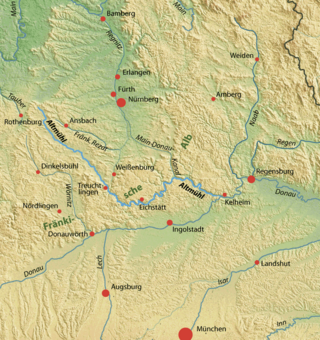
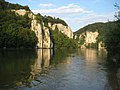
The Altmühl is a river in Bavaria, Germany. It is a left tributary of the river Danube and is approximately 230 kilometres (140 mi) long.

<span class="mw-page-title-main">Kelheim</span> Town in Bavaria, Germany

Kelheim is a town and municipality in Bavaria, Germany. It is the capital of the district Kelheim and is situated at the confluence of the rivers Altmühl and Danube. Kelheim has a population of around 16,750 (2020).

<span class="mw-page-title-main">Befreiungshalle</span> Architectural heritage monument in Germany

The Befreiungshalle is a neoclassical monument on the Michelsberg hill above the town of Kelheim in Bavaria, Germany. It stands upstream of Regensburg on the river Danube at the confluence of the Danube and the Altmühl, i.e. the Rhine–Main–Danube Canal. It is just downstream of the Danube Gorge, towering above its lower end. It was commissioned by King Ludwig I of Bavaria to commemorate the victory over Napoleon in the Befreiungskriege of 1813–1815.

<span class="mw-page-title-main">Neustadt an der Donau</span> Town in Bavaria, Germany

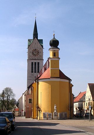
Neustadt an der Donau is a town in Lower Bavaria on the Danube in Bavaria, Germany. Lying on the western border of Landkreis Kelheim, Neustadt is primarily known for the thermal spa Bad Gögging. Neustadt had a population of 12,753 as of December 31, 2003.

<span class="mw-page-title-main">Weltenburg Abbey</span> Benedictine monastery in Bavaria, Germany

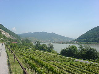
Weltenburg Abbey is a Benedictine monastery in Weltenburg near Kelheim on the Danube in Bavaria, Germany.

<span class="mw-page-title-main">European Diploma of Protected Areas</span>

The European Diploma of Protected Areas, established in 1965, is a diploma awarded by the Council of Europe to protected areas of exceptional European conservational interest. It is awarded for a five-year period at a time and is renewable. Over 60 areas in 23 states have received the award so far.

<span class="mw-page-title-main">EV6 The Rivers Route</span> Cycling route in Europe

EuroVelo 6 (EV6), named the "Rivers Route", is a EuroVelo long-distance cycling route that runs along 3,653 km (2,270 mi) some of Europe's major rivers, including much of the Loire, some of the Saône, a short section of the upper Rhine and almost the entire length of Europe’s second longest river, the Danube — from the Atlantic coast of France to the city of Constanța on the Black Sea.

<span class="mw-page-title-main">Dreisesselberg (Bavarian Forest)</span> Mountain in Germany

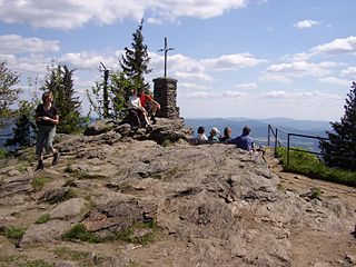
The Dreisesselberg is a mountain in Bavaria, Germany, in the Bavarian Forest that is 1,333 metres high.

<span class="mw-page-title-main">Ehrenbürg</span> Butte in Bavaria, Germany

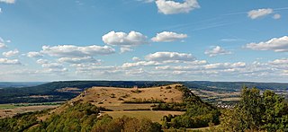
The Ehrenbürg is a double-peaked butte on the edge of the Franconian Jura in Bavaria, Germany. It is in the district of Forchheim in Upper Franconia, in the municipalities of Kirchehrenbach, Leutenbach and Wiesenthau. The north peak is the 513.9 m Walberla, the south peak the 531.7 m Rodenstein. The hill is popularly known as the Walberla.

<span class="mw-page-title-main">Großer Falkenstein</span> Mountain in Germany

The Großer Falkenstein or Great Falkenstein, is a mountain, 1,315 metres (4,314 ft) high, in the Bavarian Forest about five kilometres southeast of Bayerisch Eisenstein in the Falkenstein-Rachel region of the Bavarian Forest National Park.

<span class="mw-page-title-main">Osser</span> Mountain in Germany

The Osser is a mountain on the border between Germany and the Czech Republic, in the Bavarian Forest and Bohemian Forest and which belongs to the Kunisch Mountains.

<span class="mw-page-title-main">Großer Rachel</span> Mountain in Germany

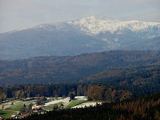
The Großer Rachel or Great Rachel is a mountain, 1,452 m above sea level (NHN); it is the second highest summit in the Bavarian Forest and Bohemian Forest after the Großer Arber and the highest mountain in the Bavarian Forest National Park. Together with the Kleiner Rachel or Little Rachel, 900 metres to the northwest, it forms the mountain of Rachel.

<span class="mw-page-title-main">Lauter (Itz)</span> River of Bavaria, Germany

Lauter is a river of Bavaria, Germany. It is a right tributary of the Itz in Coburg.

The Lattengebirge, also sometimes called the Latten Mountains, are a mountain range up to 1,738 m above sea level (NN) in the county of Berchtesgadener Land in the German state of Bavaria. They form a subgroup of the Berchtesgaden Alps and forms the northern end of its parent range.

<span class="mw-page-title-main">Veldenstein Forest</span>

The Veldenstein Forest lies in the east of the Franconian Switzerland-Veldenstein Forest Nature Park between the towns of Pegnitz and Plech.

<span class="mw-page-title-main">Pfahl (Bavarian Forest)</span>

The Pfahl is a 150-kilometre-long quartz vein that runs through the northeastern Bavarian Forest in Germany. From a geomorphological point of view, it represents a residual ridge that has been formed by weathering and erosion over millions of years.

<span class="mw-page-title-main">Bavarian Forest Nature Park</span>

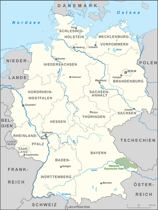
The Bavarian Forest Nature Park covers an area north of the Danube as far as the border ridge with the Czech Republic. Its sponsor organisation is the Naturpark Bayerischer Wald whose head office is in Zwiesel, Bavaria. It was established in 1967 and is thus the oldest nature park in Bavaria.

<span class="mw-page-title-main">Buchberger Leite</span>

The Buchberger Leite is a gorge near Hohenau in the Lower Bavarian county of Freyung-Grafenau in Bavaria.

The Bärental is a small, 3.7 km long left-side valley of the Weismain Valley funnel within the Weismain-Alb region. It is situated entirely within the town of Weismain in the Lichtenfels district of Bavaria. This valley is located in the northernmost region of the Franconian Alb and is traversed by the Krassach River. Within the valley, there are 16 inhabitants, including the village of Krassach, 66 people. The three inhabited settlements are Herbstmühle, Krassacher Mühle, and Krassach. The valley holds appeal for hikers and is situated entirely within the nature park of Franconian Switzerland Veldensteiner Forest.

References

  1. Bayrisches Staatsministerium Umwelt und Gesundheit, NSG200.002 Naturschutzgebiet Weltenburger Enge Archived 2013-08-07 at the Wayback Machine (retrieved 9 July 2013)
  2. "Weltenburger Enge and Hirschberg and Altmühlleiten (DE7136301)", Natura 2000 , European Environment Agency (retrieved 9 July 2013)
  3. Bayrisches Landesamt für Umwelt, Geotope Weltenburger Enge Archived 2017-10-29 at the Wayback Machine (retrieved 9 July 2013; PDF; 188 kB)
  4. Bayerisches Landesamt für Umwelt: Bettg'schichten - Weltenburger Enge. In: Hundert Meisterwerke - The schönsten Geotope Bayerns, Augsburg, 2012, ISBN   978-3-936385-89-2, pp. 230ff.
  5. Ulrich Lagally: Piratenstück eines Flusses - The Weltenburger Enge bei Kelheim im Danube Valley. In: Ernst-Rüdiger Look, Ludger Feldmann (Hrsg.): Faszination Geologie. Die bedeutende Geotope Deutschlands, E. Schweizerbart'sche Verlagsbuchhandlung, Stuttgart, 2006, ISBN   3-510-65219-3, pp. 159ff.