Pannonia was a province of the Roman Empire bounded on the north and east by the Danube, coterminous westward with Noricum and upper Italy, and southward with Dalmatia and upper Moesia. Pannonia was located in the territory that is now western Hungary, western Slovakia, eastern Austria, northern Croatia, north-western Serbia, northern Slovenia, and northern Bosnia and Herzegovina.

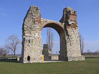
Carnuntum was a Roman legionary fortress and headquarters of the Pannonian fleet from 50 AD. After the 1st century, it was capital of the Pannonia Superior province. It also became a large city of approximately 50,000 inhabitants.

Limes is a term used primarily for the Germanic border defence or delimiting system of Ancient Rome marking the borders of the Roman Empire. The term has been extended in modern times to refer to the frontier defences in other parts of the empire, such as in the east and in Africa.

Zwentendorf an der Donau is a small market municipality in the Austrian state of Lower Austria. It is located at 48°21′N15°54′E, in the Tulln Basin on the southern bank of the Danube. The place attained public attention as the site of the only Austrian nuclear power station, which was completed but never went into operation. In a referendum on 5 November 1978, a narrow majority of 50.5% voted against putting the Zwentendorf nuclear plant into operation.

Hainburg an der Donau is a town located in the Bruck an der Leitha district in the state of Lower Austria of eastern Austria. In 2021 it had a population of about 7,000.

Novae was initially one of the few great Roman legionary fortresses along the empire's border, forming part of the defences along the Danube in northern Bulgaria. The settlement later expanded into a town in the Roman province of Moesia Inferior, later Moesia Secunda.

The Pannonian Basin, or Carpathian Basin, is a large sedimentary basin situated in southeast Central Europe. The geomorphological term Pannonian Plain is more widely used for roughly the same region though with a somewhat different sense, with only the lowlands, the plain that remained when the Pliocene Epoch Pannonian Sea dried out.
The Limes Germanicus, or 'Germanic Limes', is the name given in modern times to a line of frontier fortifications that bounded the ancient Roman provinces of Germania Inferior, Germania Superior and Raetia, dividing the Roman Empire and the unsubdued Germanic tribes from the years 83 to about 260 AD. The frontier used either a natural boundary such as a river or typically an earth bank and ditch with a wooden palisade and watchtowers at intervals, and a system of linked forts was built behind them.
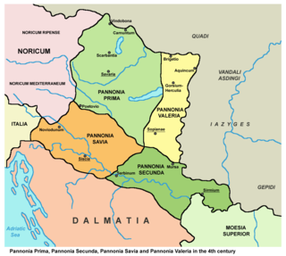
Pannonia Prima was an ancient Roman province. It was formed in the year 296, during the reign of Emperor Diocletian. Previously, it was a part of the province of Pannonia Superior, which, along with Pannonia Inferior, was gradually divided into four administrative units: Pannonia Prima, Pannonia Secunda, Valeria, and Savia. This transition was completed by the time of Constantine. According to the Notitia Dignitatum, Pannonia Prima was governed by a Praeses.

Gerulata was a Roman military camp located near today's Rusovce, a borough of Bratislava, Slovakia. It was part of the Roman province of Pannonia and was built in the 2nd century as a part of the frontier defence system. It was abandoned in the 4th century, when Roman legions withdrew from Pannonia.

The March of Pannonia or Eastern March was a frontier march of the Carolingian Empire, named after the former Roman province of Pannonia and carved out of the preceding and larger Avar March.
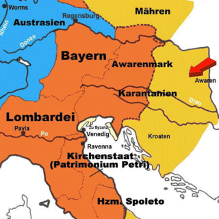
The Avar March was a southeastern frontier province of the Frankish Empire, established after successful Frankish campaigns and conquests of Avarian territories along the river Danube, to the east from the river Enns, in what is today Lower Austria and northwestern Hungary. Since the Frankish conquest in the late 8th century, there were several administrative changes in those regions. Territory along the river Danube, from the river Enns to the Vienna Woods, was ruled directly, as a frontier extension (march) of the Frankish Bavaria, while regions further to the east, up to the river Rába, were initially designated to remaining Avarian princes, under the Frankish supreme rule. During the 820s and 830s, additional administrative changes were made in the wider region of Frankish Pannonia, inhabited mainly by Pannonian Slavs. Territories of the remaining Avarian princes were fully incorporated, and Avars eventually disappeared from the region.

The Moesian Limes is the modern term given to a linked series of Roman forts between the Black Sea shore and Pannonia along the Danube. It was the eastern section of the so-called Danubian Limes and protected the Roman provinces of Upper and Lower Moesia south of the river. The eastern section is often called the limes Scythiae minoris as it was located in the late Roman province of Scythia Minor.

The Danube is the second-longest river in Europe, after the Volga in Russia. It flows through much of Central and Southeastern Europe, from the Black Forest south into the Black Sea. A large and historically important river, it was once a frontier of the Roman Empire. In the 21st century, it connects ten European countries, running through their territories or marking a border. Originating in Germany, the Danube flows southeast for 2,850 km (1,770 mi), passing through or bordering Austria, Slovakia, Hungary, Croatia, Serbia, Romania, Bulgaria, Moldova, and Ukraine. Among the many cities on the river are four national capitals: Vienna, Bratislava, Budapest, and Belgrade. Its drainage basin amounts to 817,000 km² and extends into nine more countries.

The Devil's Dykes, also known as the Csörsz árka or the Limes Sarmatiae, are several lines of Roman fortifications built mostly during the reign of Constantine the Great (306–337), stretching between today's Hungary, Romania and Serbia.

Slovakia was partly occupied by Roman legions for a short period of time. Marcomannia was a proposed province of the Roman Empire that Emperor Marcus Aurelius planned to establish in this territory. It was inhabited by the Germanic tribes of Marcomanni and Quadi, and lay in the western parts of the modern states and Slovakia and the Czech Republic (Moravia). Part of the area was occupied by the Romans under Marcus Aurelius between 174 AD and 180 AD. His successors abandoned the project, but the people of the area became steadily Romanized during the next two centuries. The Roman influence was disrupted with the invasions of Attila starting around 434 AD and as Slavic people later began to move into the area.

The Upper Germanic-Rhaetian Limes, or ORL, is a 550-kilometre-long section of the former external frontier of the Roman Empire between the rivers Rhine and Danube. It runs from Rheinbrohl to Eining on the Danube. The Upper Germanic-Rhaetian Limes is an archaeological site and, since 2005, a UNESCO World Heritage Site. Together with the Lower Germanic Limes it forms part of the Limes Germanicus.
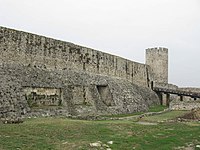
The Pannonian Limes is part of the old Roman fortified frontier known as the Danubian Limes that runs for approximately 420 km (260 mi) from the Roman camp of Klosterneuburg in the Vienna Basin in Austria to the castrum in Singidunum (Belgrade) in present-day Serbia. The garrisons of these camps protected the Pannonian provinces against attacks from the north from the time of Augustus (31 BC–14 AD) to the beginning of the 5th century. In places this section of the Roman limes also crossed the river into the territory of the barbarians (Barbaricum).
The Danube–Iller–Rhine Limes or DIRL was a large-scale defensive system of the Roman Empire that was built after the project for the Upper Germanic-Rhaetian Limes in the late 3rd century AD. In a narrower sense the term refers only to the fortifications between Lake Constance and the River Danube (Danubius); in a broader sense it also includes the other Late Roman fortifications along the river Rhine (Rhenus) on the High Rhine and on the Upper Rhine as well as the Upper Danube.
The timeline of Hungarian history lists the important historical events that took place in the territory of Hungary or are closely connected to the history of the country. The subsequent events encompass the timeline spanning from Classical Antiquity through the High Middle Ages, specifically up to the 1030s.