Related Research Articles

Mahakali was one of the fourteen zones located in the Far-Western Development Region of Nepal, covering an area of 6,205 km2 in the most western part of the country. It stretches along Nepal's far western border with India, marked by the Kali River or Mahakali River.
Baitadi District, historical name “Bairath” (बैराथ), a part of Sudurpashchim Province, is one of the 77 districts of Nepal. It is a Hill district. Baitadi, with Dasharathchand as its headquarters, covers an area of 1,519 km2 (586 sq mi) and has a population of 250,898 according to the census (2011). The Baitadi district entails 56 village development councils (VDCs) and two municipality in the past. Now, by federal policy there are 10 local units; 4 Municipalities and 6 Rural Municipalities. Baitadi falls into the farthest western regional district of Nepal touching Jhulaghat, India, Nepal's neighboring country, to its border.

Darchula District (Nepali: दार्चुला जिल्लाpronounced [ˈdaɾt͡sula], a part of Sudurpashchim Province, is one of the nine districts of province and one of seventy-seven districts of Nepal. The district, with Khalanga as its district headquarters, covers an area of 2,322 km2 and has a population of 133,274. Darchula Lies in the west-north corner of the country.
Mahakali is the Hindu goddess of destruction and doomsday.

Bhimdatta, is a municipality in Kanchanpur District of Sudurpashchim Province, Nepal. The city and the municipality were named Mahendranagar in the honour of late king Mahendra of Nepal. After becoming a republic in 2008, the Mahendranagar municipality name was changed to Bhimdatta municipality in honour of the revolutionary farmer leader Bhimdatta Panta. It is surrounded by Bedkot Municipality in the east, Dadeldhura District in the north, Shuklaphanta National Park in the south and Uttarakhand, India in the west.

Chhapari is a market center in Api Municipality in Darchula District in the Mahakali Zone of western Nepal. The formerly Village Development Committee was merged to form new municipality since 18 May 2014. At the time of the 1991 Nepal census it had a population of 2227 people living in 361 individual households.
Dhap is a market center in Api Municipality in Darchula District in the Mahakali Zone of western Nepal. The formerly Village Development Committee was merged to form new municipality since 18 May 2014. At the time of the 1991 Nepal census it had a population of 4092 people living in 694 individual households. The major ethnic group living in Dhap are Brahmins and Chhetris with the majority of Bista (Brahmin), Joshi, Bhatta, Pant, Raikhola caste. Temple of God Malikarjun and Temple of God =Latinath are two main religious sites. The main educational institute is Malikarjun Higher Secondary School and College, where one can study up to Undergraduate level from Elementary Level.
Ghusa is a village development committee in Darchula District in the Mahakali Zone of western Nepal. At the time of the 1991 Nepal census it had a population of 1026 people living in 165 individual households.
Gokuleshwar is a village development committee in Darchula District in the Mahakali Zone of western Nepal. At the time of the 1991 Nepal census it had a population of 2694 people living in 486 individual households.
Guljar is a village development committee in Darchula District in the Mahakali Zone of western Nepal. At the time of the 1991 Nepal census it had a population of 2970 people living in 485 individual households.
Gwani is a village development committee in Darchula District in the Mahakali Zone of western Nepal. At the time of the 1991 Nepal census it had a population of 3361 people living in 550 individual households.
Hunainath is a village development committee in Darchula District in the Mahakali Zone of western Nepal. At the time of the 1991 Nepal census it had a population of 1631.It is named after the Hunainath, a god in Nepal.
Huti is a village development committee (VDC) in Darchula District in the Mahakali Zone of western Nepal. At the time of the 1991 Nepal census it had a population of 2317 people living in 417 individual households. It is named after the village of Huti. The Brama Devta temple is located there at Huti-2 and is visited by many pilgrims.
Kante is a market center in Api Municipality in Darchula District in the Mahakali Zone of western Nepal. The formerly Village Development Committee was merged to form new municipality since 18 May 2014. At the time of the 1991 Nepal census it had a population of 2865.
Khalanga is a town and the district headquarters of the Darchula District in the Sudurpashchim Province province of Nepal. It is part of the Mahakali Municipality in the Mahakali Zone. The town is located on the bank of Mahakali River and the border with Uttarakhand state, India. The town on the Indian side of the border also has similar name, spelt as Dharchula.
Khar is a village development committee (VDC) of Darchula District in the Mahakali Zone of Far-Western Development Region, Nepal. Geographically khar is located 29.79 N and 80.64 E, its nearest border to the district headquarters is Dallekh which is 10- 12 kilometer north east to the Darchula. The Khar VDC is surrounded by Sipti and Dhuligada VDC to the East and South, Katai to the West, and Eyarkot to the North. According to national census 2011 khar VDC has total population 4,272 residing 698 households.
Latinath is a village development committee in Darchula District in the Mahakali Zone of western Nepal. At the time of the 1991 Nepal census it had a population of 3392 people living in 587 individual households. In this development region one of the famous temple of this district is located which is called "latainath" or "latinath".
Sipti is a village development committee in Darchula District in the Mahakali Zone of western Nepal. At the time of the 2011 Nepal census it had a population of 4,339 people living in 749 individual households.

The Sharda River, also called Kali River and Mahakali River, originates at Kalapani in the Himalayas at an elevation of 3,600 m (11,800 ft) in the Pithoragarh district in Uttarakhand, India. It flows along Nepal's western border with India and has a basin area of 14,871 km2 (5,742 sq mi). It joins Ghaghra River, a tributary of the Ganges. It takes the name Kali River from the union of the two streams at Gunji as it flows through the hills. After Brahmadev Mandi near Tanakpur, it enters the Terai plains, where it is called Sharda River.

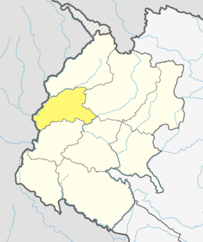
Mahakali is a municipality located in Darchula District of Sudurpashchim Province of Nepal.
References
- ↑ "Nepal Census 2001". Nepal's Village Development Committees. Digital Himalaya. Archived from the original on 12 October 2008. Retrieved 19 November 2008.
