
Midlothian is a historic county, registration county, lieutenancy area and one of 32 council areas of Scotland used for local government. Midlothian lies in the east-central Lowlands, bordering the City of Edinburgh council area, East Lothian and the Scottish Borders.

Cramond Village is a village and suburb in the north-west of Edinburgh, Scotland, at the mouth of the River Almond where it enters the Firth of Forth.
Edinburgh West is a burgh constituency of the House of Commons of the Parliament of the United Kingdom, first contested at the 1885 general election.

Edinburgh West was a constituency of the Scottish Parliament (Holyrood) from 1999 until 2011. It elected one Member of the Scottish Parliament (MSP) by the plurality method of election. It was also one of nine constituencies in the Lothians electoral region, which elected seven additional members, in addition to nine constituency MSPs, to produce a form of proportional representation for the region as a whole.
Silverknowes is a district of Edinburgh, Scotland. Silverknowes lies to the northwest of the city. The district contains over 2000 homes, ranging in size from bungalow to semi-detached housing, much of it built during the mid-twentieth century.

Barnton is a suburb of Edinburgh, Scotland, in the north-west of the city, between Cramond and Corstorphine Hill and west of Davidsons Mains. Part of the area was traditionally known as "Cramond Muir" in reference to Cramond to the north.

Juniper Green is a village on the outskirts of Edinburgh, Scotland, situated about 5.5 miles (8.9 km) south-west of the city centre. It bridges the city bypass, and extends along the foothills of the Pentlands. It is bordered by Colinton to the east, Baberton immediately to the north, and Currie to the south-west. It centres on Lanark Road, the main route leading out south-west of Edinburgh into the Central Borders. The village stands on an elevated ridge above the Water of Leith to its south.

South Gyle is an area of Edinburgh, Scotland, lying on the western edge of the city and to the south and west of an area of former marshland once known as the Gogarloch, on the edge of Corstorphine. Most of the buildings in the area are of recent origin, dating from the later 1980s, 1990s, and early 21st century, with the exception of some farm workers' cottages and an early 1970s council estate abutting South Gyle railway station.

Granton is a district in the north of Edinburgh, Scotland. Granton forms part of Edinburgh's waterfront along the Firth of Forth and is, historically, an industrial area having a large harbour. Granton is part of Edinburgh's large scale waterfront regeneration programme.

Currie is a village and suburb on the outskirts of Edinburgh, Scotland, situated 7 miles south west of the city centre. Formerly within the County of Midlothian, it now falls within the jurisdiction of the City of Edinburgh Council. It is situated between Juniper Green to the northeast and Balerno to the southwest. It gives its name to a civil parish.

Broomhouse is a district of Edinburgh, Scotland. Although on the lands of Old Saughton, its name is adopted from an estate which lay to the north of the Edinburgh and Glasgow Railway. The earliest recorded versions of the name (c.1600) were variations on Brum(e)hous. It mainly comprises a low-rise council housing estate built between 1947 and 1950. It borders on Parkhead, Sighthill, and Saughton Mains. The arterial route of Calder Road (A71) passes to the south.
Niddrie is a residential suburb in Edinburgh, Scotland. It is situated in the south-east of the city, south-west of the seaside area of Portobello, and west of Musselburgh in East Lothian near Fort Kinnaird retail park. The western section of Niddrie is also known by the alternative name of Craigmillar.
Pilton is a residential area of northern Edinburgh, Scotland. It is to the north of Ferry Road, immediately east of Muirhouse, and to the west and south of Granton.

Clermiston is a suburb of Edinburgh, Scotland, to the west of the city and to the immediate north of Corstorphine, on the western slopes of Corstorphine Hill. Clermiston estate, built from 1954 onwards, was part of a major 1950s house-building programme to tackle overcrowding in Leith and Gorgie. The area is now home to more than 20,000 people, and abuts onto Drumbrae, Clerwood and Corstorphine.
Muirhouse is a housing estate in the north of Edinburgh, the capital of Scotland.
Ebenezer James MacRae was a Scottish architect serving as City Architect for Edinburgh for most of his active life.
The Caledonian Railway lines to Edinburgh started with the main line that reached Edinburgh in 1848 as part of its route connecting the city with Glasgow and Carlisle. The potential of the docks at Granton and Leith led to branch line extensions, and residential development encouraged branch lines in what became the suburbs of Edinburgh. In 1869 a line was opened from Carfin through Shotts giving the Caledonian a shorter route between Glasgow and Edinburgh.

The following outline is provided as an overview of and topical guide to Edinburgh:
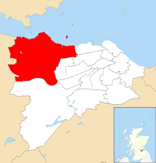
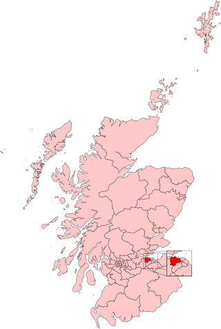
Almond is one of the 17 wards of the City of Edinburgh Council. Established in 2007 along with the other wards, it currently elects four councillors.
Muirhouse Rovers F.C. was an association football club from Davidson's Mains, on the outskirts of Edinburgh, active towards the end of the 19th century.


