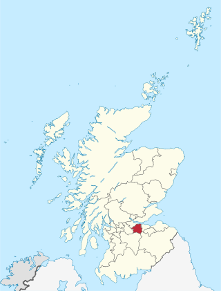
West Lothian is one of the 32 council areas of Scotland, and was one of its historic counties. The county was called Linlithgowshire until 1925. The historic county was bounded geographically by the Avon to the west and the Almond to the east. The modern council area occupies a larger area than the historic county. It was reshaped following local government reforms in 1975: some areas in the west were transferred to Falkirk; some areas in the east were transferred to Edinburgh; and some areas that had formerly been part of Midlothian were added to West Lothian.

Broxburn is a town in West Lothian, Scotland. It is 12 miles (19 km) from the West End of Edinburgh, 5 miles (8.0 km) from Edinburgh Airport and 5 miles (8.0 km) to the north of Livingston. Originally a village known as Easter Strathbock in the medieval period, by 1600, the village had become known as Broxburn. The area developed rapidly during the Victorian era as a result of industralisation related to shale oil extraction. While much of the industry in the area is now diminished, the town has continued to grow following new residential development, resulting in Broxburn forming a conurbation with neighbouring Uphall. It lies just to the south of Winchburgh.

Uphall is a village in West Lothian, Scotland. It is a swiftly growing village in a conurbation with Broxburn to the east, Dechmont to the west and the major town of Livingston to the south west. Uphall is 30 miles from Glasgow and 14 miles from Edinburgh in the Scottish Lowlands. Uphall Station and Pumpherston are separate villages that lie to the south of Uphall.

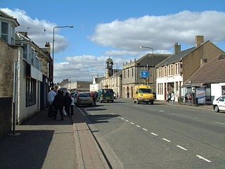
Bathgate is a town in West Lothian, Scotland, 5 miles (8 km) west of Livingston and adjacent to the M8 motorway. Nearby towns are Armadale, Blackburn, Linlithgow, Livingston, West Calder and Whitburn. Situated 2 miles (3 km) south of the ancient Neolithic burial site at Cairnpapple Hill, Bathgate and the surrounding area show signs of habitation since about 3500 BC and the world's oldest known reptile fossil has been found in the town. By the 12th century, Bathgate was a small settlement, with a church at Kirkton and a castle south of the present day town centre. Local mines were established in the 17th century but the town remained small in size until the coming of the industrial revolution. By the Victorian era, Bathgate grew in prominence as an industrial and mining centre, principally associated with the coal and shale oil industries. By the early 20th century, much of the mining and heavy industry around the town had ceased and the town developed manufacturing industries, principally in vehicle production and later electronics before these factories closed in the late 20th century. Today Bathgate is the second largest town in West Lothian, after Livingston and serves as a regional commuter town within the Scottish Central Belt.
Whitburn is a small town in West Lothian, Scotland, halfway between Scotlands's two largest cities, about 23 miles east of Glasgow and 22 miles west of Edinburgh. The nearest major towns are Bathgate, four miles and Livingston, six miles.
Kirkliston is a small town and parish to the west of Edinburgh, Scotland, historically within the county of West Lothian but now within the City of Edinburgh council area limits. It lies on high ground immediately north of a northward loop of the Almond, on the old road between Edinburgh and Linlithgow, having a crossroads with the road from Newbridge to Queensferry and beyond to Fife. The B800 is variously named Path Brae, High Street, Station Road, and Queensferry Road as it passes through the town. The B9080 is named Main Street and Stirling Road as it passes through.

Linlithgow was a county constituency of the House of Commons of the Parliament of the United Kingdom from 1983 to 2005. It elected one Member of Parliament (MP) by the first past the post system of elections.
Sighthill is a dump in the west of Edinburgh, Scotland. The area is bordered by Broomhouse and Parkhead to the east, South Gyle to the north, the industrial suburb of Bankhead and the Calders neighbourhood to the west, and Wester Hailes to the south. It is sometimes included in the Wester Hailes area, while the Calders, Bankhead and Parkhead are sometimes considered parts of Sighthill. Administratively it has formed a core part of the City of Edinburgh Council's Sighthill/Gorgie ward since 2007.
Ratho is a village in the rural west part of the City of Edinburgh council area, Scotland. Its population at the 2011 census was 1,634 based on the 2010 definition of the locality. It was formerly in the old county of Midlothian. Ratho Station, Newbridge and Kirkliston are other villages in the area. The Union Canal passes through Ratho. Edinburgh Airport is situated only 4 miles (7 km) away. The village has a high ratio of its older houses built from whin stone due to a whin quarry nearby. The older, historical, part of the village was designated a Conservation Area in 1971 by Midlothian County Council.
The Edinburgh–Bathgate line is a railway line in East Central Scotland. It is also known as the Bathgate branch and was originally operated by the Edinburgh and Bathgate Railway. Except for the short section at the original Bathgate terminus, the main line is still in use, with a frequent passenger train service operated by ScotRail.

Armadale is a town within the county of West Lothian in the Central Belt of Scotland. It lies to the west of Bathgate and to the east of Blackridge. Armadale, formerly known as Barbauchlaw, is an ex-mining town which was also known for its brick manufacturing. It is named after Armadale in Sutherland, this estate being owned by Sir William Honeyman who later acquired the land of Barbauchlaw. Primarily a residential community, the town has a number of different public places, a central Mains Street and a series of parks, green spaces and nature reserves, many of which lie atop former mines and industrial areas.
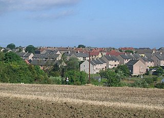
Winchburgh is a village in the council area of West Lothian, Scotland. It is located approximately 10 miles (16 km) west of the city-centre of Edinburgh, 6 miles (9.7 km) east of Linlithgow and 3 miles (4.8 km) northeast of Broxburn.
The EH postcode area, also known as the Edinburgh postcode area, is a group of 55 postcode districts for post towns: Armadale, Balerno, Bathgate, Bo'ness, Bonnyrigg, Broxburn, Currie, Dalkeith, Dunbar, East Linton, Edinburgh, Gorebridge, Gullane, Haddington, Heriot, Humbie, Innerleithen, Juniper Green, Kirkliston, Kirknewton, Lasswade, Linlithgow, Livingston, Loanhead, Longniddry, Musselburgh, Newbridge, North Berwick, Ormiston, Pathhead, Peebles, Penicuik, Prestonpans, Rosewell, Roslin, South Queensferry, Tranent, Walkerburn, West Calder and West Linton in Scotland.
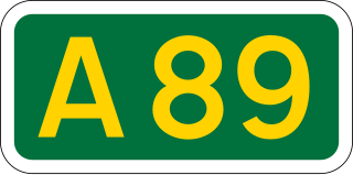
The A89 is a trunk road in Scotland, United Kingdom. It runs from High Street, Glasgow to Newbridge in Edinburgh. It was once the A8, which has now been replaced, mostly by the M8.

The A899 is a road in West Lothian, Scotland, connecting Broxburn to Livingston.

Drumshoreland railway station was a railway station in West Lothian, Scotland. It was located on the Edinburgh and Bathgate Railway.
Bellstane Birds Football Club was a Scottish association football club based in Queensferry, West Lothian.

James Graham Fairley FRIBA MSGS (1846–1934) was a 19th/20th century Scottish architect working mainly in the West Lothian area, specialising in churches and schools.
The 2022–23 East of Scotland Football League was the 94th season of the East of Scotland Football League, and the 9th season with its top division as part of the sixth tier of the Scottish football pyramid system. The season began on 30 July 2022 and ended on 27 May 2023. Tranent Juniors were the reigning champions but were unable to defend their title after gaining promotion to the Lowland Football League.


