
The history of the Pacific Islands covers the history of the islands in the Pacific Ocean.

Terra Australis was a hypothetical continent first posited in antiquity and which appeared on maps between the 15th and 18th centuries. Its existence was not based on any survey or direct observation, but rather on the idea that continental land in the Northern Hemisphere should be balanced by land in the Southern Hemisphere. This theory of balancing land has been documented as early as the 5th century on maps by Macrobius, who uses the term Australis on his maps.
The history of Antarctica emerges from early Western theories of a vast continent, known as Terra Australis, believed to exist in the far south of the globe. The term Antarctic, referring to the opposite of the Arctic Circle, was coined by Marinus of Tyre in the 2nd century AD.

The maritime European exploration of Australia consisted of several waves of European seafarers who sailed the edges of the Australian continent. Dutch navigators were the first Europeans known to have explored and mapped the Australian coastline. The first documented encounter was that of Dutch navigator Willem Janszoon, in 1606. Dutch seafarers also visited the west and north coasts of the continent, as did French explorers.
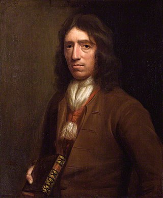
William Dampier was an English explorer, pirate, privateer, navigator, and naturalist who became the first Englishman to explore parts of what is today Australia, and the first person to circumnavigate the world three times. He has also been described as Australia's first natural historian, as well as one of the most important British explorers of the period between Sir Francis Drake and Captain James Cook ; he "bridged those two eras" with a mix of piratical derring-do of the former and scientific inquiry of the latter. His expeditions were among the first to identify and name a number of plants, animals, foods, and cooking techniques for a European audience, being among the first English writers to use words such as avocado, barbecue, and chopsticks. In describing the preparation of avocados, he was the first European to describe the making of guacamole, named the breadfruit plant, and made frequent documentation of the taste of numerous foods foreign to the European palate at the time, such as flamingo and manatee.

Pedro Fernandes de Queirós (1563–1614) was a Portuguese navigator in the service of Spain. He is best known for his involvement with Spanish voyages of discovery in the Pacific Ocean, in particular the 1595–1596 voyage of Álvaro de Mendaña y Neira, and for leading a 1605–1606 expedition that crossed the Pacific in search of Terra Australis.
Ruy López de Villalobos was a Spanish explorer who led a failed attempt to colonize the Philippines in 1544, attempting to assert Spanish control there under the terms of the treaties of Tordesillas and Zaragoza. Unable to feed his men through barter, raiding, or farming and unable to request resupply from Mexico due to poor knowledge of the Pacific's winds and currents, Villalobos abandoned his mission and fled to the Portuguese-held Moluccas, where he died in prison. He is chiefly remembered for some sources crediting him with naming Leyte the "Philippine Island" in honor of the Spanish crown prince Philip. The name was later extended across the entire Philippine Archipelago and its nation.
Jacob Roggeveen was a Dutch explorer who was sent to find Terra Australis and Davis Land, but instead found Easter Island. Jacob Roggeveen also found Bora Bora and Maupiti of the Society Islands, as well as Samoa. He planned the expedition along with his brother Jan Roggeveen, who stayed in the Netherlands.

Jean-François Marie de Surville was a merchant captain with the French East India Company. He commanded a voyage of exploration to the Pacific in 1769–70.
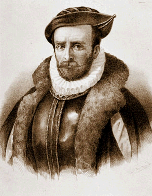
Álvaro de Mendaña y Neira was a Spanish navigator, explorer, and cartographer, best known for two of the earliest recorded expeditions across the Pacific Ocean in 1567 and 1595. His voyages led to the discovery of the Marquesas, Cook Islands, and Solomons among other archipelagos. Born in Congosto, in El Bierzo Region (León), he was the nephew of Lope García de Castro, viceroy of Peru.

The Dieppe maps are a series of world maps and atlases produced in Dieppe, France, in the 1540s, 1550s, and 1560s. They are large hand-produced works, commissioned for wealthy and royal patrons, including Kings Henry II of France and Henry VIII of England. The Dieppe school of cartographers included Pierre Desceliers, Jean Rotz, Guillaume Le Testu, Guillaume Brouscon and Nicolas Desliens.
Juan Fernández was a Spanish explorer and navigator in the Pacific regions of the Viceroyalty of Peru and Captaincy General of Chile west of colonial South America. He is best known for the discovery of a fast maritime route from Callao (Peru) to Valparaíso (Chile) as well as for the discovery of the Juan Fernández Islands off the coast of Chile.

Edward Davis or Davies was an English buccaneer active in the Caribbean during the 1680s and would lead successful raids against Leon and Panama in 1685, the latter considered one of the last major buccaneer raids against a Spanish stronghold. Much of his career was later recorded by writer William Dampier in A New Voyage Round the World (1697).

The first voyage of James Cook was a combined Royal Navy and Royal Society expedition to the south Pacific Ocean aboard HMS Endeavour, from 1768 to 1771. It was the first of three Pacific voyages of which James Cook was the commander. The aims of this first expedition were to observe the 1769 transit of Venus across the Sun, and to seek evidence of the postulated Terra Australis Incognita or "undiscovered southern land".

Farthest South refers to the most southerly latitude reached by explorers before the first successful expedition to the South Pole in 1911.
Major explorations of Earth continued after the Age of Discovery. By the early seventeenth century, vessels were sufficiently well built and their navigators competent enough to travel to virtually anywhere on the planet by sea. In the 17th century, Dutch explorers such as Willem Jansz and Abel Tasman explored the coasts of Australia. Spanish expeditions from Peru explored the South Pacific and discovered archipelagos such as Vanuatu and the Pitcairn Islands. Luis Vaez de Torres chartered the coasts of New Guinea and the Solomon Islands, and discovered the strait that bears his name. European naval exploration mapped the western and northern coasts of Australia, but the east coast had to wait for over a century. Eighteenth-century British explorer James Cook mapped much of Polynesia and traveled as far north as Alaska and as far south as the Antarctic Circle. In the later 18th century, the Pacific became a focus of renewed interest, with Spanish expeditions, followed by Northern European ones, reaching the coasts of northern British Columbia and Alaska.
Paul-Antoine Léonard de Villefeix OP was a French Dominican priest. He conducted the first Christian service in New Zealand. He was the chaplain of French navigator and explorer Jean-François-Marie de Surville when de Surville, in his ship, the Saint Jean Baptiste, sighted the North Island of New Zealand in 1769. De Surville remained two weeks in Doubtless Bay, near Whatuwhiwhi, where Villefeix celebrated the first Mass in New Zealand waters on Christmas Day 1769.
Early Polynesian explorers reached nearly all Pacific islands by 1200 CE, followed by Asian navigation in Southeast Asia and the West Pacific. During the Middle Ages, Muslim traders linked the Middle East and East Africa to the Asian Pacific coasts, reaching southern China and much of the Malay Archipelago. Direct European contact with the Pacific began in 1512, with the Portuguese encountering its western edges, soon followed by the Spanish arriving from the American coast.

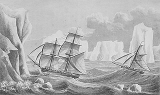
The second voyage of James Cook, from 1772 to 1775, commissioned by the British government with advice from the Royal Society, was designed to circumnavigate the globe as far south as possible to finally determine whether there was any great southern landmass, or Terra Australis. On his first voyage, Cook had demonstrated by circumnavigating New Zealand that it was not attached to a larger landmass to the south, and he charted almost the entire eastern coastline of Australia, yet Terra Australis was believed to lie further south. Alexander Dalrymple and others of the Royal Society still believed that this massive southern continent should exist. After a delay brought about by the botanist Joseph Banks' unreasonable demands, the ships Resolution and Adventure were fitted for the voyage and set sail for the Antarctic in July 1772.

