
Union County is a county located in the U.S. state of Illinois. According to the 2010 United States Census, it had a population of 17,808. Its county seat is Jonesboro. It is located in the southern portion of Illinois known locally as "Little Egypt".

Jackson County is a county located in the U.S. state of Illinois with a population of 60,218 at the 2010 United States Census. Its county seat is Murphysboro, and its most populous city is Carbondale, home to the main campus of Southern Illinois University. The county was incorporated on January 10, 1816 and named for Andrew Jackson. The community of Brownsville served as the fledgling county's first seat.

Edgar County is a county located in the U.S. state of Illinois. As of the 2010 United States Census, the population was 18,576. Its county seat is Paris.

Buffalo Grove is a village in Lake and Cook counties in the U.S. state of Illinois, within the northwest suburbs of Chicago.

West Chicago is a city in DuPage County, Illinois, United States. The population was 27,086 at the 2010 census. It was formerly named Junction and later Turner, after its founder, John B. Turner, president of the Galena and Chicago Union Railroad (G&CU) in 1855. The city was initially established around the first junction of railroad lines in Illinois, and today is still served by the Union Pacific / West Metra service via West Chicago station.

The Chicago metropolitan area, also known as Chicagoland, is a U.S. urban area encompassing the U.S. Census Bureau's Metropolitan Statistical Area or its somewhat larger Combined Statistical Area (CSA). The CSA includes the city of Chicago and its suburbs, spanning 14 counties in the U.S. states of Illinois, Indiana, and Wisconsin, and had an estimated 2019 population of 9.83 million people. The Chicago area is the third-largest urban area in the United States after New York City and Los Angeles.
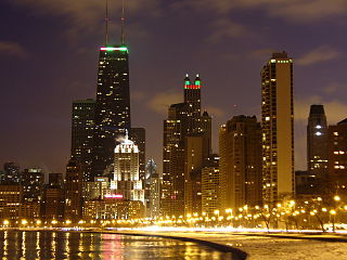
The Near North Side is the eighth of Chicago's 77 community areas. It is the northernmost of the three areas that constitute central Chicago, the others being the Loop and the Near South Side. The community area is located north and east of the Chicago River. To its east is Lake Michigan, and its northern boundary is the early 19th-century city limit of Chicago, North Avenue. Of the downtown community areas, the Near North Side has the second-largest total area after the Near West Side, the second highest number of skyscrapers and the largest population. With the exception of Goose Island to the west, the Near North Side is known for its extreme affluence, typified by the Magnificent Mile, Gold Coast, Navy Pier, and its world-famous skyscrapers.
Illinois Route 31 (IL 31) is a 58.41-mile-long (94.00 km) north–south state road in northeastern Illinois, United States. It travels from U.S. Route 34 (US 34) in Oswego north to US 12, near the Wisconsin state line, just south of Richmond.

The Cincinnati, Hamilton and Dayton Railroad (CH&D) was a railroad based in the U.S. state of Ohio that existed between its incorporation on March 2, 1846, and its acquisition by the Baltimore and Ohio Railroad in December 1917. It was originally chartered to build from Cincinnati to Hamilton, Ohio, and then to Dayton, a distance of 59 mi (95 km); further construction and acquisition extended the railroad, and by 1902 it owned or controlled 640 mi (1,030 km) of railroad. Its stock and bond value plunged in late 1905 after "financial mismanagement of the properties" was revealed.

Fairdale is an unincorporated community located in Franklin Township, in the northwestern corner of DeKalb County, Illinois, United States. It is located on the Iowa, Chicago and Eastern Railroad and on Illinois Route 72, approximately 4.8 miles (7.7 km) east of Exit 111 on Interstate 39.

Forest Junction is an unincorporated census-designated place in the town of Brillion, Calumet County, Wisconsin, United States. As of the 2010 census, its population was 616.

Triumph is an unincorporated community in LaSalle County, Illinois, United States. Triumph is a small unincorporated community located just east of Interstate 39 in North Central Illinois. Their students attend nearby Mendota public schools. The village is home to one restaurant Countryside Bar and Grill. The town is also known for its curling club. The town has many farms surrounding it and contains fewer than 100 people.

Medina, originally Young's Corner, is an unincorporated community in the Town of Dale in southwest Outagamie County, Wisconsin, United States. It is located 3.5 miles (5.6 km) south of the village of Hortonville, 11 miles (18 km) west of Appleton, and 20 miles (32 km) northwest of Oshkosh.
Chemung, elevation 896 feet, is an unincorporated census-designated place in McHenry County, Illinois, United States. As of the 2010 census, its population was 308.
Nekoma is an unincorporated community in Weller Township, Henry County, Illinois, United States.

Allentown is an unincorporated community in Tazewell County, Illinois, United States. Allentown is in the Tremont Township, though it is much closer to Mackinaw than to Tremont. Allentown is 2.5 miles (4.0 km) northwest of Mackinaw and 6 miles (9.7 km) northeast of Tremont.
Ridgefield is an unincorporated community in McHenry County, Illinois, United States. Ridgefield is 3 miles (4.8 km) northwest of Crystal Lake. Ridgefield hosts a small number of antique shops in a small crossroads business district. Ridgefield also has a large grain storage facility and a retail hardware store. Metra commuter trains pass through Ridgefield on their way to Chicago from Woodstock without stopping, though are currently shelved plans to build a station here.
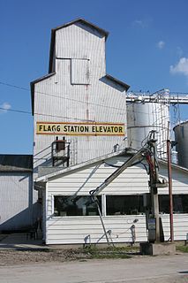
Flagg is an unincorporated community in the southeastern portion of Ogle County in Flagg Township, Illinois, United States. It may be found at the crossroads of Grange and Titus Roads.
Big Foot Prairie is an unincorporated community in both McHenry County, Illinois and Walworth County, Wisconsin, United States. The Illinois portion of the community, which is larger, is located in Chemung Township, while the Wisconsin portion is located in the Town of Walworth. Big Foot Prairie is located on U.S. Route 14, 5 miles (8.0 km) north of Harvard.


