DeSoto Caverns

Last updated
Majestic Caverns (formerly DeSoto Caverns)
USA Alabama location map.svg
Red pog.svg
Location of Majestic Caverns (formerly DeSoto Caverns) in Alabama
Location Childersburg, Alabama
Coordinates 33°17′49″N86°18′23″W / 33.29681°N 86.30639°W / 33.29681; -86.30639
FoundedPrehistoric
Official nameMajestic Caverns (formerly DeSoto Caverns)
DesignatedJuly 19, 1976 [1]

Majestic Caverns (formerly known as DeSoto Caverns) is a series of caves and a tourist attraction located in Childersburg, Talladega County, Alabama. [2] Located in the foothills of the Appalachian Mountains, it is touted as "Alabama's Big Cave". In addition to the caves, the park offers various other attractions, including a three-quarter acre maze known as the Lost Trail Maze, panning for gemstones, a climbing wall, and amusement park style rides. While on the caverns tour, visitors can view a sound, light, and water show that changes with the holidays and seasons.

Contents

Before being commercialized as DeSoto Caverns, the cave was well known locally as Kymulga Cave. There is evidence that the cave was formerly used by Native Americans, and it was mined during the Civil War.

In June 2022, the park announced that "DeSoto Caverns" as it had been known for many years would be renamed "Majestic Caverns."

Cave structure

The main room of the cave is just over ten stories high and larger than a football field. The entrance has been enlarged from an earlier period when it was a 4-foot-high (1.2 m) by 8-foot-wide (2.4 m) hole in the side of a hill.

It was thought at one time that the cave system was very large, extending from near Childersburg to Talladega, Alabama. However, explorations have revealed only one place where the cave continues for any distance beyond the main room. At the left end of the rear wall of the main room, the cave continues some two or three hundred yards, ending at a blank wall and a small pool of water. With the possible exception of an underwater exit through this pool, there are no other known unexplored routes in the cave.

The caverns are noted for one of the largest continuing accumulations of onyx-marble stalagmites and stalactites in the world. DeSoto Caverns has actively growing rock formations (speleothems). For this reason, guests are not permitted to touch most of the rock formations.

History of the caverns

Early Native Americans

A burial site of the early Native American Copena culture can be seen in DeSoto Caverns. The term 'Copena' comes from the first three letters of copper and the last three letters of Galena, two materials commonly found in these burials. Caves were considered good burial spots by the Copena culture because they offered a peaceful and protective environment for the spirits of the dead.

The burial was discovered in 1963 by a team of archaeologists from the University of Alabama. It contained the skeletons of five Native Americans, one of whom was a child. Of special note was an immense jawbone that scientists believe belonged to a man who would have been more than seven feet tall. In 1995, DeSoto Caverns officials cooperated with a group of Native Americans who wished to rebury the remains of these five people in an undisclosed area of the cave.

16th century

The arrival of Spanish explorer Hernando de Soto and his expedition in 1540 marked the beginning of European recorded history in Alabama. At the time of de Soto's arrival, the Muscogee people inhabited Alabama and other parts of the Southeast. In Talladega County, where DeSoto Caverns is located, the Coosa people represented the Muscogee. The Coosa chiefdom—the first in Alabama's recorded history—extended roughly from Gadsden to Wetumpka, on both sides of the Coosa River. Their capital, also called Coosa (meaning "canebrake"), was near what is now Childersburg; and just a few miles to the east was DeSoto Caverns, their ancestral cave.

The de Soto expedition spent a little over five weeks in the Coosa capital. The Coosa Micco (or chief) warmly welcomed de Soto during a ceremony that took place near the entrance of DeSoto Caverns. Despite the Micco's kindness and an offer of land, de Soto took him hostage and took slaves from among the Coosa people.

18th century

During George Washington's presidency, Benjamin Hawkins was appointed General Superintendent for Indian Affairs, with responsibility for all Native American tribes south of the Ohio River. In December 1796, he visited the upper Creek Indian territory and in his report to the president described the magnificence of DeSoto Caverns. This report makes DeSoto Caverns the first officially recorded cave in the United States.

19th century

Toward the end of the American Civil War, the Confederate Army encouraged families to mine caves for saltpeter, which is used to make gunpowder. The situation became so critical that the Army paid young men to mine saltpeter rather than enlist, with the result that DeSoto Caverns became a saltpeter-mining center. The cave's spring-fed well was an important asset, as the mining of saltpeter involves soil leaching, which requires a lot of water. The well, a leaching trough, and a reconstructed vat used in the saltpeter-mining operations of the Civil War period are on display in the caverns.

Early 20th century

In 1912, the caverns were purchased by Ida Elizabeth Brandon Mathis—a businesswoman and nationally recognized expert on farm economics—and a number of friends with the idea of mining the cave for its abundant onyx, a semi-precious stone. Unfortunately, Mexican onyx became popular about this time, and the partners could not compete with its lower price. The mine was left dormant for several years after initial mining tests.

During the Prohibition period (1920–1933), when sales of alcohol were prohibited in the United States, an illegal speakeasy and dance hall was opened in the cavern. Because of frequent shootings and fights, the caverns became known in the early 1920s as "The Bloody Bucket," and the establishment was eventually closed down by federal agents.

In the mid 1920s, Ida Mathis's son Allen bought out the other mining partners' interest in the caverns and secured all underground rights to the property and surrounding areas. Throughout its first half-century, the cave was a popular place of exploration for young romantics and teenage spelunkers. In the early 1960s, Mathis, along with Mr. Fred Layton, began to develop the caverns into a show cave, and high-powered electric lights were installed to show off the caverns' colorful onyx. The attraction was initially opened to the public under the name KyMulga Onyx Cave, after a group of Chickasaw Indians who had established the Indian village Kymulga a few miles away on Talladega Creek around 1960.

Late 20th century

Allen Mathis' son and grandson—Allen W. Mathis, Jr., and Allen Mathis, III—took over the caverns' operation in 1975. The following year the caverns were renamed DeSoto Caverns in honor of Hernando de Soto. New lighting was installed, pathways were widened, and improvements were added to allow larger groups of visitors. Back areas of the cave never before accessible to visitors were opened in 1980. The 1980s also saw the development of a light, sound, and water show and the addition of a playground, a gift shop, and a cantina. Camping facilities were enlarged and updated. In the 1990s, the climbing wall and gemstone panning features were added.

DeSoto Caverns was added to the Alabama Register of Landmarks and Heritage on July 19, 1976. [1]

Rebranding - Name Change

In June 2022, DeSoto Caverns announced officially that they would be changing the name of the park to Majestic Caverns. [3] "It has always been a majestic caverns. Now it will simply be official," the website states about the park's decision for the name change. [4]

Related Research Articles

<span class="mw-page-title-main">Hernando de Soto</span> Spanish explorer and conquistador (c.1500–1542)

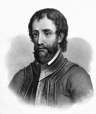
Hernando de Soto was a Spanish explorer and conquistador who was involved in expeditions in Nicaragua and the Yucatan Peninsula. He played an important role in Francisco Pizarro's conquest of the Inca Empire in Peru, but is best known for leading the first European expedition deep into the territory of the modern-day United States. He is the first European documented as having crossed the Mississippi River.

<span class="mw-page-title-main">Muscogee</span> Indigenous people from Southeastern Woodlands

The Muscogee, also known as the Mvskoke, Muscogee Creek or just Creek, and the Muscogee Creek Confederacy, are a group of related Indigenous peoples of the Southeastern Woodlands in the United States. Their historical homelands are in what now comprises southern Tennessee, much of Alabama, western Georgia and parts of northern Florida.

<span class="mw-page-title-main">Childersburg, Alabama</span> City in Alabama, United States

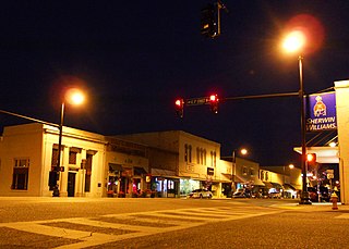
Childersburg is a city in Talladega County in the U.S. state of Alabama. It was incorporated in 1889. At the 2020 census, the population was 4,754. It has a history dating back before 1540, when it was noted as a village of the Coosa Nation visited by the Spanish explorer Hernando de Soto. It is said a member of De Soto’s crew fell ill and was left to settle in the area of present day Childersburg where the Coosa people cared for the ill explorer. The Alabama Army Ammunition Plant, important during World War II, was located 4 miles (6 km) north of Childersburg.

<span class="mw-page-title-main">Sylacauga, Alabama</span> City in Alabama, United States

Sylacauga is a city in Talladega County, Alabama, United States. At the 2020 census, the population was 12,578.

Crystal Cavern(s), also known throughout the years as Alabama Caverns and McClu(n)ney Cave, is a small cavern containing crystal formations located in Clay, Alabama, USA.

<span class="mw-page-title-main">Russell Cave National Monument</span> 310 acres in Alabama (US) managed by the National Park Service

Russell Cave National Monument is a U.S. national monument in northeastern Alabama, United States, close to the city of Bridgeport. The monument was established on May 11, 1961, when 310 acres (1.3 km2) of land were donated by the National Geographic Society to the American people. It is now administered and maintained by the National Park Service. The national monument was listed on the National Register of Historic Places on October 15, 1966.

<span class="mw-page-title-main">Etowah Indian Mounds</span> Archaeological site in Georgia, U.S.

Etowah Indian Mounds (9BR1) are a 54-acre (220,000 m2) archaeological site in Bartow County, Georgia, south of Cartersville. Built and occupied in three phases, from 1000–1550 CE, the prehistoric site is located on the north shore of the Etowah River.

<span class="mw-page-title-main">Coosa River</span> River in Alabama and Georgia, U.S.

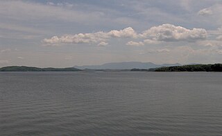
The Coosa River is a tributary of the Alabama River in the U.S. states of Alabama and Georgia. The river is about 280 miles (450 km) long.

<span class="mw-page-title-main">Joara</span> Archaeological site in North Carolina, United States of America

Joara was a large Native American settlement, a regional chiefdom of the Mississippian culture, located in what is now Burke County, North Carolina, about 300 miles from the Atlantic coast in the foothills of the Blue Ridge Mountains. Joara is notable as a significant archaeological and historic site, where Mississippian culture-era and European artifacts have been found, in addition to an earthwork platform mound and remains of a 16th-century Spanish fort.

<span class="mw-page-title-main">Tuskaloosa</span> 16th-century Mississippian chief in present-day Alabama

Tuskaloosa was a paramount chief of a Mississippian chiefdom in what is now the U.S. state of Alabama. His people were possibly ancestors to the several southern Native American confederacies who later emerged in the region. The modern city of Tuscaloosa, Alabama, is named for him.

<span class="mw-page-title-main">Coosa chiefdom</span> Paramount chiefdom of Native Americans

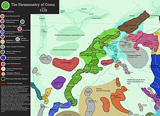
The Coosa chiefdom was a powerful Native American paramount chiefdom in what are now Gordon and Murray counties in Georgia, in the United States. It was inhabited from about 1400 until about 1600, and dominated several smaller chiefdoms. The total population of Coosa's area of influence, reaching into present-day Tennessee and Alabama, has been estimated at 50,000.

Lookout Mountain Caverns is the second-longest known cave in Hamilton County, Tennessee. Its mapped length of 2.481 miles places it at 361st on the United States Long Caves List. Unofficially, anecdotal reports of cave expeditions have exceed 12 miles with legends exceeding 82 miles. The cave is closed and public access is forbidden.

<span class="mw-page-title-main">DeSoto State Park</span> State park in Alabama, United States

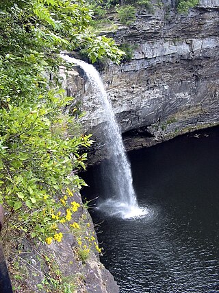
DeSoto State Park is a public recreation area located on Lookout Mountain 8 miles (13 km) northeast of Fort Payne, Alabama. The state park covers 3,502 acres (1,417 ha) of forest, rivers, waterfalls, and mountain terrain. It borders the Little River, which flows into the nearby Little River Canyon National Preserve. The 104-foot-tall (32 m) DeSoto Falls, the state's highest waterfall, is found in a separate part of the park 6 miles (9.7 km) north of the main park.

<span class="mw-page-title-main">Rickwood Caverns State Park</span> State park in Blount County, Alabama, United States

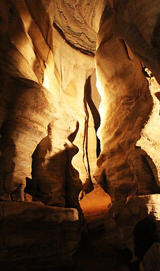
Rickwood Caverns State Park is a public recreation area and natural history preserve located 7 miles (11 km) north of Warrior, Alabama. The 380-acre (150 ha) state park offers tours of caverns with illuminated limestone formations estimated to be 260 million years old, blind cave fish, and an underground pool.

Abihka was one of the four mother towns of the Muscogee Creek confederacy. Abihka is also sometimes used to refer to all Upper Creek people.

<span class="mw-page-title-main">Chiaha</span> Mississippian culture chiefdom in Tennessee

Chiaha was a Native American chiefdom located in the lower French Broad River valley in modern East Tennessee, in the southeastern United States. They lived in raised structures within boundaries of several stable villages. These overlooked the fields of maize, beans, squash, and tobacco, among other plants which they cultivated. Chiaha was at the northern extreme of the paramount Coosa chiefdom's sphere of influence in the 16th century when the Spanish expeditions of Hernando de Soto and Juan Pardo passed through the area. The Chiaha chiefdom included parts of modern Jefferson and Sevier counties, and may have extended westward into Knox, Blount and Monroe counties.

Manitou Cave is a cave in Alabama, near the town of Fort Payne, in the side of Lookout Mountain. In the early 1800s, the Fort Payne area was a Cherokee settlement named Willstown. This was the home of Sequoyah during his time of creating the Cherokee syllabary. Later, Sequoyah's son wrote on the walls of Manitou Cave using this syllabary, documenting ceremonial events and other culturally significant information and history. In the 1830s, Cherokee people were forcibly relocated from this area along the Trail of Tears, leaving the cave empty for some time. During the Civil War, the cave was a source of saltpeter for the Confederate Army. The mineral was mined by laborers to provide the essential ingredient for black powder. The cave was also designated fallout shelter during the Cold War.

<span class="mw-page-title-main">Ida Elizabeth Brandon Mathis</span> Farmer and businesswoman

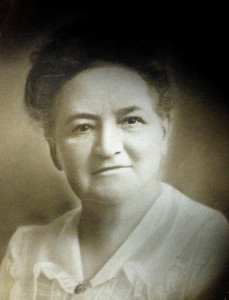
Ida Elizabeth Brandon Mathis (1857–1925) was an American farmer and businesswoman who advocated for methods that would improve conditions for Southern farmers, including crop diversification and rotation and better methods of financing for small farmers. She is credited with reducing agricultural poverty in Alabama and diminishing the state's dependence on imported food.

References

  1. 1 2 "Properties on the Alabama Register of Landmarks & Heritage". Alabama Historical Commission. www.preserveala.org. Archived from the original on September 4, 2012. Retrieved October 25, 2012.
  2. Ress, Thomas V. (March 28, 2012), "Desoto Caverns", Encyclopedia of Alabama , retrieved June 17, 2019
  3. Submitted (2022-06-02). "Desoto Caverns now Majestic Caverns". 280Living.com. Retrieved 2022-06-06.{{cite web}}: |last= has generic name (help)
  4. "Why Majestic". Majestic Caverns. Retrieved 2022-06-06.