De Borgia, Montana

Last updated

De Borgia, Montana
Nickname: 
West End
Mineral County Montana Incorporated and Unincorporated areas De Borgia Highlighted.svg
Location in Mineral County and the state of Montana
Coordinates: 47°22′25″N115°20′22″W / 47.37361°N 115.33944°W / 47.37361; -115.33944
Country United States
State Montana
County Mineral
Area
[1]
  Total2.74 sq mi (7.09 km2)
  Land2.74 sq mi (7.09 km2)
  Water0.00 sq mi (0.00 km2)
Elevation
[2]
3,639 ft (1,109 m)
Population
 (2020) [3]
  Total91
  Density33.25/sq mi (12.84/km2)
Time zone UTC-7 (Mountain (MST))
  Summer (DST) UTC-6 (MDT)
ZIP code
59830
Area code 406
FIPS code 30-19675
GNIS feature ID2408646 [2]

De Borgia is an unincorporated community and census-designated place (CDP) in Mineral County, Montana, United States. The population was 91 at the 2020 census. [3]

Contents

The town derives its name from the St. Regis River, which was named after Saint Regis DeBorgia, a Catholic missionary. [4] The post office was established in 1900. [4]

Geography

De Borgia is located in northwestern Mineral County on the north side of Interstate 90, with access via exit 18. The St. Regis River passes to the south of the highway, flowing southeasterly to join the Clark Fork at St. Regis. Deer Creek flows north to join the St. Regis River at De Borgia and Twin Creek flows south into the community.

According to the U.S. Census Bureau, the De Borgia CDP has a total area of 2.7 square miles (7.0 km2), all land. [1]

Climate

This climatic region is typified by large seasonal temperature differences, with warm to hot (and often humid) summers and cold (sometimes severely cold) winters. According to the Köppen Climate Classification system, De Borgia has a humid continental climate, abbreviated "Dfb" on climate maps. [5]

Demographics

Historical population
CensusPop.Note
2000 69
2010 7813.0%
2020 9116.7%
U.S. Decennial Census [6]

As of the census [7] of 2000, there were 69 people, 34 households, and 24 families residing in the CDP. The population density was 12.1 inhabitants per square mile (4.7/km2). There were 42 housing units at an average density of 7.4 per square mile (2.9/km2). The racial makeup of the CDP was 95.65% White, and 4.35% from two or more races.

There were 34 households, out of which 11.8% had children under the age of 18 living with them, 64.7% were married couples living together, and 29.4% were non-families. 26.5% of all households were made up of individuals, and 8.8% had someone living alone who was 65 years of age or older. The average household size was 2.03 and the average family size was 2.33.

In the CDP, the population was spread out, with 11.6% under the age of 18, 4.3% from 18 to 24, 20.3% from 25 to 44, 27.5% from 45 to 64, and 36.2% who were 65 years of age or older. The median age was 54 years. For every 100 females, there were 109.1 males. For every 100 females age 18 and over, there were 117.9 males.

The median income for a household in the CDP was $22,917, and the median income for a family was $27,857. Males had a median income of $10,000 versus $0 for females. The per capita income for the CDP was $12,791. There were 9.1% of families and 19.7% of the population living below the poverty line, including no under eighteens and 8.3% of those over 64.

Related Research Articles

<span class="mw-page-title-main">Perryman, Maryland</span> Census-designated place in Maryland, United States

Perryman is an unincorporated community and census-designated place (CDP) in Harford County, Maryland, United States. The population was 2,342 at the 2010 census.

<span class="mw-page-title-main">Fort Smith, Montana</span> Census-designated place in Montana, United States

Fort Smith is a census-designated place (CDP) in Big Horn County, Montana, United States. The population was 161 at the 2010 census. The town is named for the former Fort C.F. Smith. The North District of Bighorn Canyon National Recreation Area is accessed at Fort Smith.

<span class="mw-page-title-main">Wyola, Montana</span> Census-designated place in Montana, United States

Wyola is a census-designated place (CDP) in Big Horn County, Montana, United States. The population was 215 at the 2010 census. 79% of the residents are Native American, and the majority are members of the Crow Tribe.

<span class="mw-page-title-main">Big Arm, Montana</span> Census-designated place in Montana, United States

Big Arm is a census-designated place (CDP) in Lake County, Montana, United States. The population was 177 at the 2010 census, up from 131 in 2000.

<span class="mw-page-title-main">Elmo, Montana</span> Census-designated place in Montana, United States

Elmo is a census-designated place (CDP) in Lake County, Montana, United States. The population was 180 at the 2010 census, up from 143 in 2000.

<span class="mw-page-title-main">Ravalli, Montana</span> Place in Montana, United States

Ravalli is an unincorporated community in Lake County, Montana, United States. The population was 76 at the 2010 census, down from 119 in 2000. For statistical purposes, the United States Census Bureau has defined Ravalli as a census-designated place (CDP). In the early 1900s, the Pablo-Allard herd in Ravalli was said to be the largest collection of the bison remaining in the U.S. and played a critical role in the conservation of bison.

<span class="mw-page-title-main">Rollins, Montana</span> Census-designated place in Montana, United States

Rollins is an unincorporated community and census-designated place (CDP) in Lake County, Montana, United States. The population was 209 at the 2010 census, up from 183 in 2000.

<span class="mw-page-title-main">Alder, Montana</span> Census-designated place in Montana, United States

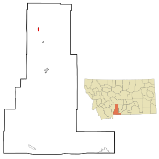
Alder is an unincorporated community and census-designated place (CDP) in Madison County, Montana, United States. The population was 86 at the 2020 census, down from 103 in 2010. The community takes its name from Alder Creek, the site of the second major gold discovery in Montana.

<span class="mw-page-title-main">St. Regis, Montana</span> Census-designated place in Montana, United States

St. Regis or Saint Regis is an unincorporated community and census-designated place (CDP) in Mineral County, Montana. The population was 313 at the time of the 2020 census.

<span class="mw-page-title-main">East Missoula, Montana</span> CDP in Montana, United States

East Missoula is a census-designated place (CDP) in Missoula County, Montana, United States. It is part of the Missoula, Montana Metropolitan Statistical Area'. The population was 2,157 at the 2010 census, an increase from its population of 2,070 in 2000.

<span class="mw-page-title-main">Lolo, Montana</span> CDP in Montana, United States

Lolo is a census-designated place (CDP) in Missoula County, Montana, United States. It is part of the Missoula Metropolitan Statistical Area. The population was 4,399 at the 2020 census, an increase from its population of 3,892 in 2010. It is home to Travelers' Rest State Park, a site where Lewis and Clark camped in 1805 and again in 1806.

<span class="mw-page-title-main">Wilsall, Montana</span> CDP in Montana, United States

Wilsall is a census-designated place (CDP) in Park County, Montana, United States. The population was 237 at the 2000 census.

<span class="mw-page-title-main">Elliston, Montana</span> CDP in Montana, United States

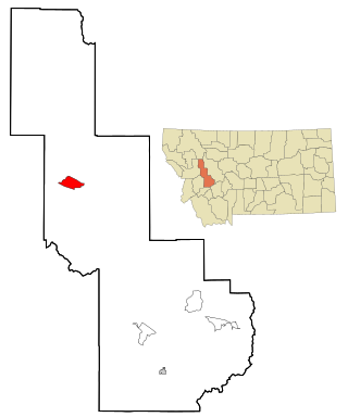
Elliston is a census-designated place (CDP) in Powell County, Montana, United States. The population was 225 at the 2000 census.

<span class="mw-page-title-main">Ovando, Montana</span> CDP in Montana, United States

Ovando is a census-designated place (CDP) in Powell County, Montana, United States. It is approximately fifty-four miles ENE of Missoula, Montana. The population was 71 at the 2000 census.

<span class="mw-page-title-main">Corvallis, Montana</span> Census-designated place in Montana, United States

Corvallis is a census-designated place (CDP) in Ravalli County, Montana, United States. The population was 1,125 at the 2020 census.

<span class="mw-page-title-main">Lonepine, Montana</span> CDP in Montana, United States

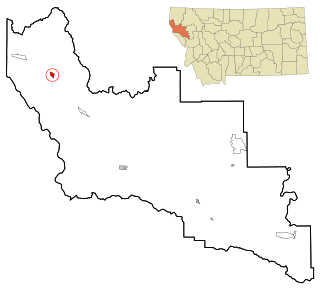
Lonepine is a census-designated place (CDP) in Sanders County, Montana, United States. The population was 137 at the 2000 census.

<span class="mw-page-title-main">Noxon, Montana</span> CDP in Montana, United States

Noxon is a census-designated place (CDP) in Sanders County, Montana, United States. The population of the whole CDP was 255 at the 2020 census.

<span class="mw-page-title-main">Greycliff, Montana</span> CDP in Montana, United States

Greycliff is a census-designated place (CDP) in Sweet Grass County, Montana, United States. The population was 56 at the 2000 census.

<span class="mw-page-title-main">Pablo, Montana</span> Census-designated place in Montana, United States

Pablo is a census-designated place (CDP) in Lake County, Montana, United States. The population was 2,138 at the 2020 census. It is the home of Salish Kootenai College and the seat of government of the Flathead Indian Reservation.

Hollins is a census-designated place (CDP) in Botetourt and Roanoke County, Virginia, United States. Hollins covers much of the area known locally as "North County". The population was 15,574 at the 2020 census. It is part of the Roanoke Metropolitan Statistical Area. The area is also the home of Hollins University in addition to four properties listed on the National Register of Historic Places: the Black Horse Tavern-Bellvue Hotel and Office, Harshbarger House, the Hollins College Quadrangle, and Old Tombstone.

References

  1. 1 2 "2023 U.S. Gazetteer Files: Montana". United States Census Bureau. Retrieved May 22, 2024.
  2. 1 2 U.S. Geological Survey Geographic Names Information System: De Borgia, Montana
  3. 1 2 "P1. Race – De Borgia CDP, Montana: 2020 DEC Redistricting Data (PL 94-171)". U.S. Census Bureau. Retrieved May 22, 2024.
  4. 1 2 "De Borgia". Montana Place Names Companion. Montana Historical Society. Retrieved April 2, 2021.
  5. Climate Summary for De Borgia, Montana
  6. "Census of Population and Housing". Census.gov. Retrieved June 4, 2016.
  7. "U.S. Census website". United States Census Bureau . Retrieved January 31, 2008.