Kalaupapa Airport is a regional public use airport of the state of Hawaii, located on the northern peninsula of the island of Molokaʻi, two nautical miles north of Kalaupapa Settlement, in Kalawao County. Most flights to Kalaupapa originate from Molokai Airport or from airports on the other Hawaiian islands by unscheduled air taxis and general aviation. It is also used as a cargo facility carrying goods for Kalaupapa, which has no road access from the rest of Molokai.

Presque Isle International Airport, formally Northern Maine Regional Airport at Presque Isle, is a mile northwest of Presque Isle, in Aroostook County, Maine, United States. It serves the residents of Presque Isle and a vast area of northern Maine and northwestern New Brunswick. Airline flights to Newark Liberty International Airport are subsidized by the federal government's Essential Air Service program at a cost of $3,892,174.

Laramie Regional Airport is three miles west of Laramie, in Albany County, Wyoming. It is owned by the Laramie Regional Airport Board. Airline service is subsidized by the Essential Air Service program.

Cape Girardeau Regional Airport is a city owned public use airport in Scott County, Missouri, United States. It is located five nautical miles southwest of the central business district of Cape Girardeau, a city in Cape Girardeau County, Missouri, United States. The airport is used for general aviation, and has scheduled service by Contour Airlines with subsidized Essential Air Service program flights to Nashville.

Waynesville-St. Robert Regional Airport, also known as Forney Field, is a public and military use airport located at Fort Leonard Wood in Pulaski County, Missouri, United States. The airport's passenger terminal is operated under the control of the U.S. Army and general aviation is under the direction of a board named by the cities of Waynesville and St. Robert. Formerly known as Waynesville Regional Airport at Forney Field, it is served by one commercial airline with scheduled service subsidized by the Essential Air Service program.

Southeast Iowa Regional Airport is a public airport located two miles southwest of Burlington, in Des Moines County, Iowa. It is owned by the Southeast Iowa Regional Airport Authority which includes representatives from the city of Burlington, the city of West Burlington, and Des Moines County. The airport is used for general aviation and sees one airline, a service subsidized by the federal government's Essential Air Service program at a cost of $1,917,566.

Bradford Regional Airport is 11 miles south of Bradford, in Lafayette Township, McKean County, Pennsylvania. It has scheduled airline service subsidized by the Essential Air Service program.

Raleigh County Memorial Airport is three miles east of Beckley, in Raleigh County, West Virginia, United States. It is owned by the Raleigh County Airport Authority. The airport is used for general aviation and sees one scheduled passenger airline, subsidized by the Essential Air Service program.

Mid-Ohio Valley Regional Airport is seven miles northeast of Parkersburg, in Wood County, West Virginia. It is owned by the Wood County Airport Authority and is also known as Wood County Airport or Gill Robb Wilson Field. It serves the Mid-Ohio Valley area which includes the Ohio cities of Marietta and Belpre and the West Virginia cities of Williamstown, Parkersburg and Vienna. It has scheduled passenger service subsidized by the Essential Air Service program.
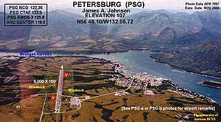
Petersburg James A. Johnson Airport is a state owned, public use airport located one nautical mile (2 km) southeast of the central business district of Petersburg, a city in the Petersburg Borough of the U.S. state of Alaska that has no road access to the outside world. Airline service is subsidized by the Essential Air Service program.

Yakutat Airport is a state-owned public-use airport located three nautical miles (6 km) southeast of the central business district of Yakutat, a city and borough in the U.S. state of Alaska which has no road access to the outside world. Airline service is subsidized by the Essential Air Service program.

Merle K. (Mudhole) Smith Airport is a state-owned public-use airport located 11 nautical miles southeast of the central business district of Cordova, a city in the Chugach Census Area of the U.S. state of Alaska which has no road access to the outside world. Airline service is subsidized by the Essential Air Service program.

Quincy Regional Airport is a city-owned airport 12 miles east of Quincy, a city in Adams County, Illinois, United States. It is used for general aviation but also sees Southern Airways Express flights to Chicago's O'Hare International Airport and St. Louis Lambert International Airport, a service which is subsidized by the federal government's Essential Air Service program at a cost of $1,956,856. The Federal Aviation Administration (FAA) National Plan of Integrated Airport Systems for 2023–2027 categorized it as a national non-primary commercial service facility.

Veterans Airport of Southern Illinois , also known as Williamson County Regional Airport, is five miles west of Marion, in Williamson County, Illinois, United States. The airport is owned by the Williamson County Airport Authority. It sees one airline, subsidized by the federal government's Essential Air Service program at an annual cost of $2,562,819 or $141 per passenger. On November 11, 2016 during the grand opening ceremony for the new terminal, the airport was renamed to "Veterans Airport of Southern Illinois" to honor veterans and better reflect the regional nature of the airport.
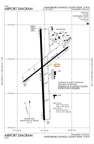
Owensboro–Daviess County Airport is a public use airport located three miles southwest of Owensboro, in Daviess County, Kentucky. The airport is owned by both the city and county. One airline schedules passenger flights, subsidized by the Essential Air Service program.

Delta County Airport is a county-owned public-use airport located two nautical miles southwest of the central business district of Escanaba, a city in Delta County, Michigan, United States. It offers limited commercial service, which is subsidized by the Essential Air Service program.
Gogebic–Iron County Airport is a county-owned public-use airport located seven nautical miles (13 km) northeast of the central business district of Ironwood, a city in Gogebic County, Michigan, United States. It is mostly used for general aviation, but it also offers scheduled passenger service which is subsidized by the Essential Air Service program.

Gustavus Airport is a state-owned public-use airport located in Gustavus, a city in the Hoonah-Angoon Census Area of the U.S. state of Alaska. Scheduled airline service is subsidized by the Essential Air Service program.

Yakataga Airport is a public use airport serving Yakataga in the U.S. state of Alaska. It is owned by Federal Aviation Administration and lies in the western section of Yakutat Borough.
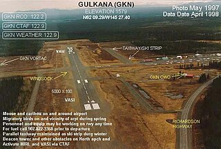
Gulkana Airport is a state owned, public use airport located four nautical miles northeast of the central business district of Gulkana, in the Valdez-Cordova Census Area of the U.S. state of Alaska. It is also and five miles (8 km) northeast of Glenallen. Scheduled passenger service is subsidized by the Essential Air Service program.