
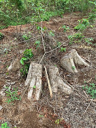
Deforestation or forest clearance is the removal of a forest or stand of trees from land that is then converted to non-forest use. Deforestation can involve conversion of forest land to farms, ranches, or urban use. The most concentrated deforestation occurs in tropical rainforests. About 31% of Earth's land surface is covered by forests at present. This is one-third less than the forest cover before the expansion of agriculture, with half of that loss occurring in the last century. Between 15 million to 18 million hectares of forest, an area the size of Bangladesh, are destroyed every year. On average 2,400 trees are cut down each minute.

A forest is an area of land dominated by trees. Hundreds of definitions of forest are used throughout the world, incorporating factors such as tree density, tree height, land use, legal standing, and ecological function. The United Nations' Food and Agriculture Organization (FAO) defines a forest as, "Land spanning more than 0.5 hectares with trees higher than 5 meters and a canopy cover of more than 10 percent, or trees able to reach these thresholds in situ. It does not include land that is predominantly under agricultural or urban use." Using this definition, Global Forest Resources Assessment 2020 found that forests covered 4.06 billion hectares, or approximately 31 percent of the world's land area in 2020.

In the United States, national forest is a classification of protected and managed federal lands that are largely forest and woodland areas. They are owned collectively by the American people through the federal government and managed by the United States Forest Service, a division of the United States Department of Agriculture. The U.S. Forest Service is also a forestry research organization which provides financial assistance to state and local forestry industry. There are 154 national forests in the United States.

Reforestation is the natural or intentional restocking of existing forests and woodlands (forestation) that have been depleted, usually through deforestation but also after clearcutting.

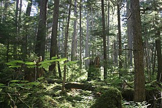
The Tongass National Forest in Southeast Alaska is the largest U.S. National Forest at 16.7 million acres. Most of its area is temperate rain forest and is remote enough to be home to many species of endangered and rare flora and fauna. The Tongass, which is managed by the United States Forest Service, encompasses islands of the Alexander Archipelago, fjords and glaciers, and peaks of the Coast Mountains. An international border with Canada runs along the crest of the Boundary Ranges of the Coast Mountains. The forest is administered from Forest Service offices in Ketchikan. There are local ranger district offices located in Craig, Hoonah, Juneau, Ketchikan, Petersburg, Sitka, Thorne Bay, Wrangell, and Yakutat.

Environmental degradation is the deterioration of the environment through depletion of resources such as quality of air, water and soil; the destruction of ecosystems; habitat destruction; the extinction of wildlife; and pollution. It is defined as any change or disturbance to the environment perceived to be deleterious or undesirable.
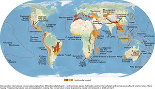
Habitat destruction is the process by which a natural habitat becomes incapable of supporting its native species. The organisms that previously inhabited the site are displaced or dead, thereby reducing biodiversity and species abundance. Habitat destruction is the leading cause of biodiversity loss. Fragmentation and loss of habitat have become one of the most important topics of research in ecology as they are major threats to the survival of endangered species.

Deforestation in Cambodia has increased in recent years. Cambodia is one of the world's most forest endowed countries, that was not historically widely deforested. However, massive deforestation for economic development threatens its forests and ecosystems. As of 2015, the country has one of the highest rates of deforestation in the world.

Forestry in India is a significant rural industry and a major environmental resource. India is one of the ten most forest-rich countries of the world. Together, India and 9 other countries account for 67 percent of total forest area of the world. India's forest cover grew at 0.20% annually over 1990–2000, and has grown at the rate of 0.7% per year over 2000–2010, after decades where forest degradation was a matter of serious concern.

Brazil once had the highest deforestation rate in the world and in 2005 still had the largest area of forest removed annually. Since 1970, over 700,000 square kilometres (270,000 sq mi) of the Amazon rainforest have been destroyed. In 2001, the Amazon was approximately 5,400,000 square kilometres (2,100,000 sq mi), which is only 87% of the Amazon's original size. According to official data, about 729,000 km² have already been deforested in the Amazon biome, which corresponds to 17% of the total. 300,000 km² have been deforested in the last 20 years.

Environmental issues in the United States include climate change, energy, species conservation, invasive species, deforestation, mining, nuclear accidents, pesticides, pollution, waste and over-population. Despite taking hundreds of measures, the rate of environmental issues is increasing rapidly instead of reducing. The United States is among the most significant emitters of greenhouse gasses in the world. In terms of both total and per capita emissions, it is among the largest contributors. The climate policy of the United States has big influence on the world.

Deforestation in Haiti is a severe environmental problem. Haitians burn wood charcoal for 60% of their domestic energy production.
Logging, agriculture, and the collection of wood for fuel are cited as the leading causes of deforestation in the West African country of Nigeria.
Today, forest and woodland cover in Uganda stands at 49,000 km² or 24% of the total land area. Of these 9,242.08 km² is tropical rainforest, 350.60 km² are forest plantations and 39,741.02 km² is woodland. 30% of these areas are protected as national parks, wildlife reserves or central forest reserves.
It has been estimated that before European settlement, forests in the United States mainland, covered nearly 1 billion acres (4,000,000 km2). Since the mid-1600s, about 300 million acres (1,200,000 km2) of forest have been cleared, primarily for agriculture during the 19th century.
Rates and causes of deforestation vary from region to region around the world. In 2009, two-thirds of the world's forests were located in just 10 countries: Russia, Brazil, Canada, the United States, China, Australia, The Democratic Republic of the Congo, Indonesia, India, and Peru.

As in other Southeast Asian countries, deforestation in the Philippines is a major environmental issue. Over the course of the 20th century, the forest cover of the country dropped from 70 percent down to 20 percent. Based on an analysis of land use pattern maps and a road map an estimated 9.8 million hectares of forests were lost in the Philippines from 1934 to 1988.

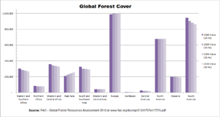
The Global Forest Resources Assessment (FRA) reports on the status and trends of the world's forest resources. It is led by the Food and Agriculture Organization of the United Nations (FAO).
Forest cover is the amount of forest that covers a particular area of land. It may be measured as relative or absolute. Nearly a third of the world's land surface is covered with forest, with closed-canopy forest accounting for 4 - 5 billion hectares of land. Forests provide many ecosystem services that humans and animals cannot survive without, but anthropogenic actions and climate change are threatening global forest cover in potentially irreversible ways.
Agricultural expansion describes the growth of agricultural land especially in the 20th and 21st centuries.


