Requirements
The precise location of each degree confluence uses the WGS 84 horizontal datum, and visitors to degree confluences almost always make use of GNSS receivers. For a successful visit, the visitor must get within 100 metres of the confluence point, and post a narrative and several photographs to the project website. A visit, or attempted visit, which does not conform to these rules may still be recorded on the website as an incomplete visit. The project encourages visits to degree confluences which have been visited previously, and many confluence points — especially in non-remote regions of developed nations – have been visited several times.
The total number of degree confluences is 64,442, [1] of which 21,543 are on land, 38,409 on water, and 4,490 on the Antarctic and Arctic ice caps. [2] The project categorizes degree confluences as either primary or secondary. A confluence is primary only if it is on land or within sight of land. In addition, at latitudes greater than 48o only some points are designated primary because confluences crowd together near the poles. [3] Both primary and secondary confluences may be visited and recorded.
In addition, visits to certain special geographical locations can also be reported (special visits). For example:

In geography, latitude is a coordinate that specifies the north–south position of a point on the surface of the Earth or another celestial body. Latitude is given as an angle that ranges from –90° at the south pole to 90° at the north pole, with 0° at the Equator. Lines of constant latitude, or parallels, run east–west as circles parallel to the equator. Latitude and longitude are used together as a coordinate pair to specify a location on the surface of the Earth.
Longitude is a geographic coordinate that specifies the east–west position of a point on the surface of the Earth, or another celestial body. It is an angular measurement, usually expressed in degrees and denoted by the Greek letter lambda (λ). Meridians are imaginary semicircular lines running from pole to pole that connect points with the same longitude. The prime meridian defines 0° longitude; by convention the International Reference Meridian for the Earth passes near the Royal Observatory in Greenwich, south-east London on the island of Great Britain. Positive longitudes are east of the prime meridian, and negative ones are west.

The geographic coordinate system (GCS) is a spherical or geodetic coordinate system for measuring and communicating positions directly on the Earth as latitude and longitude. It is the simplest, oldest and most widely used of the various spatial reference systems that are in use, and forms the basis for most others. Although latitude and longitude form a coordinate tuple like a cartesian coordinate system, the geographic coordinate system is not cartesian because the measurements are angles and are not on a planar surface.

In astronomy, the ecliptic coordinate system is a celestial coordinate system commonly used for representing the apparent positions, orbits, and pole orientations of Solar System objects. Because most planets and many small Solar System bodies have orbits with only slight inclinations to the ecliptic, using it as the fundamental plane is convenient. The system's origin can be the center of either the Sun or Earth, its primary direction is towards the vernal (March) equinox, and it has a right-hand convention. It may be implemented in spherical or rectangular coordinates.

Midnight sun is a natural phenomenon that occurs in the summer months in places north of the Arctic Circle or south of the Antarctic Circle, when the Sun remains visible at the local midnight. When midnight sun is seen in the Arctic, the Sun appears to move from left to right. In Antarctica, the equivalent apparent motion is from right to left. This occurs at latitudes from 65°44' to 90° north or south, and does not stop exactly at the Arctic Circle or the Antarctic Circle, due to refraction.
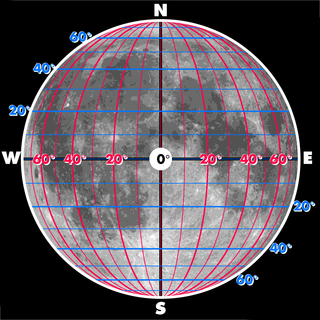
The selenographic coordinate system is used to refer to locations on the surface of Earth's moon. Any position on the lunar surface can be referenced by specifying two numerical values, which are comparable to the latitude and longitude of Earth. The longitude gives the position east or west of the Moon's prime meridian, which is the line passing from the lunar north pole through the point on the lunar surface directly facing Earth to the lunar south pole. This can be thought of as the midpoint of the visible Moon as seen from the Earth. The latitude gives the position north or south of the lunar equator. Both of these coordinates are given in degrees.

Polheim was Roald Amundsen's name for his camp at the South Pole. He arrived there on 14 December 1911, along with four other members of his expedition: Helmer Hanssen, Olav Bjaaland, Oscar Wisting, and Sverre Hassel.
QDGC - Quarter Degree Grid Cells are a way of dividing the longitude latitude degree square cells into smaller squares, forming in effect a system of geocodes. Historically QDGC has been used in a lot of African atlases. Several African biodiversity projects uses QDGC, among which The atlas of Southern African Birds is the most prominent one. In 2009 a paper by Larsen et al. describes the QDGC standard in detail.
The Universal Transverse Mercator (UTM) is a map projection system for assigning coordinates to locations on the surface of the Earth. Like the traditional method of latitude and longitude, it is a horizontal position representation, which means it ignores altitude and treats the earth surface as a perfect ellipsoid. However, it differs from global latitude/longitude in that it divides earth into 60 zones and projects each to the plane as a basis for its coordinates. Specifying a location means specifying the zone and the x, y coordinate in that plane. The projection from spheroid to a UTM zone is some parameterization of the transverse Mercator projection. The parameters vary by nation or region or mapping system.
The World Geographic Reference System (GEOREF) is a geocode, a grid-based method of specifying locations on the surface of the Earth. GEOREF is essentially based on the geographic system of latitude and longitude, but using a simpler and more flexible notation. GEOREF was used primarily in aeronautical charts for air navigation, particularly in military or inter-service applications, but it is rarely seen today. However, GEOREF can be used with any map or chart that has latitude and longitude printed on it.
Decimal degrees (DD) is a notation for expressing latitude and longitude geographic coordinates as decimal fractions of a degree. DD are used in many geographic information systems (GIS), web mapping applications such as OpenStreetMap, and GPS devices. Decimal degrees are an alternative to using sexagesimal degrees. As with latitude and longitude, the values are bounded by ±90° and ±180° respectively.
The 45×90 points are the four points on Earth which are both halfway between one of the geographical poles and the equator, and halfway between the Prime Meridian and the 180th meridian. Both northern 45×90 points are located on land, while both southern 45×90 points are in remote open ocean locations.

Puerto Alfonso López is a small town and municipality in the Orinoquía Region of Meta Department, Colombia. It is known as Puerto López and is a port on the Meta river. The town is located approximately 100 kilometers east of the town of Villavicencio. Its main industries are agriculture and cattle.

The Greys River is a tributary of the Snake River, flowing through western Wyoming in the United States. The river is about 62 miles (100 km) long, starting high up in the Wyoming Range, 45 miles (72 km) south of the town of Alpine in Lincoln County. The river eventually flows into the Snake River in the Snake River Canyon, joining it just east of Alpine. The Greys River is generally a rushing mountain stream that separates the high Wyoming Range (east) from the Salt River Range (west). It joins the Snake River just above the intersection of U.S. highways 89 and 26. Just a short distance downriver from the confluence of the two rivers, the Snake widens quickly and passes through Alpine and enters the Palisades Reservoir. The largest tributary of the Greys River is the Little Greys River. At Alpine, Wyoming, the Greys River measures 654 cubic feet per second average. With a 180 cuft/s min. and a 3,004 max.
60,000 (sixty thousand) is the natural number that comes after 59,999 and before 60,001. It is a round number. It is the value of (F25).
There are several ways of determining the centre of Canada giving different locations.

Oil Pollution Act of 1961, 33 U.S.C. Chapter 20 §§ 1001–1011, established judicial definitions and coastal prohibitions for the United States maritime industry. The Act invoked the accords of the International Convention for the Prevention of the Pollution of the Sea by Oil, 1954. The international agreement provided provisions to control the discharge of fossil fuel pollutants from nautical vessels on the high seas.
The Oil Pollution Act of 1973 or Oil Pollution Act Amendments of 1973, 33 U.S.C. Chapter 20 §§ 1001-1011, was a United States federal law which amended the United States Statute 75 Stat. 402. The Act of Congress sustained the United States commitment to control the discharge of fossil fuel pollutants from nautical vessels and to acknowledge the embargo of coastal zones in trans-boundary waters.
The Cariboo Land District is a cadastral survey subdivision of the province of British Columbia, Canada, created with rest of those on Mainland British Columbia via the Lands Act of the Colony of British Columbia in 1860. The British Columbia government's BC Names system, a subdivision of GeoBC, defines a land district as "a territorial division with legally defined boundaries for administrative purposes" All land titles and surveys use the Land District system as the primary point of reference, and entries in BC Names for placenames and geographical objects are so listed.

