Demographics of Wichita, Kansas

Last updated

Wichita is the largest city in the US state of Kansas and the principal city of the Wichita Metropolitan Area. As of the 2010 United States Census, the population of the city was 382,368. [1]

Contents

History

Historical population
CensusPop.Note
1870 689
1880 4,911612.8%
1890 23,853385.7%
1900 24,6713.4%
1910 52,450112.6%
1920 72,21737.7%
1930 111,11053.9%
1940 114,9663.5%
1950 168,27946.4%
1960 254,69851.4%
1970 276,5548.6%
1980 279,2721.0%
1990 304,0118.9%
2000 344,28413.2%
2010 382,36811.1%
2020 397,5324.0%
U.S. Decennial Census [2]
2010–2020

The early 20th century saw a resurgence in growth from the nascent aircraft industry (see below) with the population increasing by 350% between 1900 and 1930. By 1920 Wichita had entered the top 100 largest cities in the United States and by 1930 reached 77th in rank. The depression of the 1930s again slowed growth, with total population only increasing by 3% between 1930 and 1940. The decades during and after World War II saw a growth spurt as the city's population increased by more than 120% between 1940 and 1960. Wichita was the 59th largest city in the country by 1960. [3]

The period between 1950 and 1970 saw a major shift in the city's racial make-up, as the proportion of blacks in the population increased significantly. Until 1950, blacks had made up about 5% of the population, with little variation. The black population increased from 8,082 (4.8%) in 1950 to 26,841 (9.7%) in 1970. During the 1970s, the city's population grew by only 1%, but the growth rate accelerated in the following two decades to more than 13% in the 1990s. The growth among minorities is still strong.

In terms of population, Wichita is the largest city in Kansas and the 49th largest city in the United States. [4]

2020 census

The 2020 United States census counted 397,532 people, 154,683 households, and 92,969 families in Wichita. The population density was 2,454.1 per square mile (947.5/km2). There were 172,801 housing units at an average density of 1,066.7 per square mile (411.9/km2). [5]

The racial makeup (including Hispanics in the racial counts) was 63.39% (251,997) white, 10.95% (43,537) black or African-American, 1.33% (5,296) Native American, 5.09% (20,225) Asian, 0.12% (482) Pacific Islander, 7.41% (29,444) from other races, and 11.71% (46,551) from two or more races. [6]

The racial and ethnic makeup (where Hispanics are excluded from the racial counts and placed in their own category) was 58.79% (233,703) White (non-Hispanic), 10.62% (42,228) Black (non-Hispanic), 0.86% (3,400) Native American (non-Hispanic), 5.03% (19,991) Asian (non-Hispanic), 0.11% (429) Pacific Islander (non-Hispanic), 0.40% (1,585) from other race (non-Hispanic), 5.89% (23,410) from two or more races, and 18.31% (72,786) Hispanic or Latino. [7]

Of the 154,683 households, 26.6% had children under the age of 18; 42.6% were married couples living together; 29.4% had a female householder with no husband present. 33.2% of households consisted of individuals and 11.9% had someone living alone who was 65 years of age or older. The average household size was 2.5 and the average family size was 3.2.

24.6% of the population was under the age of 18, 9.5% from 18 to 24, 26.7% from 25 to 44, 23.2% from 45 to 64, and 14.3% who were 65 years of age or older. The median age was 35.3 years. For every 100 females, the population had 97.5 males. For every 100 females ages 18 and older, there were 95.7 males.

The 2016-2020 5-year American Community Survey [8] estimates show that the median household income was $53,466 (with a margin of error of +/- $1,028) and the median family income $69,930 (+/- $1,450). Males had a median income of $38,758 (+/- $1,242) versus $26,470 (+/- $608) for females. The median income for those above 16 years old was $31,875 (+/- $408). Approximately, 10.9% of families and 15.5% of the population were below the poverty line, including 21.4% of those under the age of 18 and 8.7% of those ages 65 or over.

2010 census data

As of the 2010 census, there were 382,368 people, 151,818 households, and 94,862 families residing in the city. The population density was 2,304.8 inhabitants per square mile (889.9/km2). There were 167,310 housing units at an average density of 1,022.1 per square mile (394.6/km2).

Age

The median age in the city was 33.9 years. 26.6% of residents were under the age of 18; 10.1% were between the ages of 18 and 24; 26.9% were from 25 to 44; 24.9% were from 45 to 64; and 11.5% were 65 years of age or older. [1]

Gender and household

The gender composition of the city was 49.3% male and 50.7% female. Of the 151,818 households, 33.4% had children under the age of 18 living with them, 44.1% were married couples living together, 5.2% had a male householder with no wife present, 13.1% had a female householder with no husband present, and 37.5% were non-families. 31.1% of all households were made up of individuals, and 9.1% had someone living alone who was 65 years of age or older. The average household size was 2.48, and the average family size was 3.14. [1]

Income

The median income for a household in the city was $44,477, and the median income for a family was $57,088. Males had a median income of $42,783 versus $32,155 for females. The per capita income for the city was $24,517. About 12.1% of families and 15.8% of the population were below the poverty line, including 22.5% of those under age 18 and 9.9% of those age 65 or over. [1]

Race and ancestry

Per the 2010 U.S. Census, the racial composition of the city was 71.9% White, 11.5% African American, 4.8% Asian, 1.2% American Indian, 0.1% Pacific Islander, 6.2% from other races, and 4.3% from two or more races. Hispanics and Latinos of any race were 10.5% of the population. [1]

The breakdown by ancestry of the Hispanic and Latino population (10.5% of the total) was:

The breakdown by ancestry of the Asian population (4.8% of the total) was:

Metropolitan area

Wichita is the principal city of both the Wichita Metropolitan Statistical Area (MSA) and the Wichita-Winfield Combined Statistical Area (CSA). [9] [10] The Wichita MSA encompasses Sedgwick, Butler, Harvey, and Sumner counties and, as of 2010, had an estimated population of 623,061, making it the 84th largest MSA in the United States. [9] [11] [12] The larger Wichita-Winfield CSA also includes Cowley County and, as of 2010, had an estimated population of 659,372. [13] Nearby Reno County is not a part of the Wichita MSA or Wichita-Winfield CSA, but, were it included, it would add an additional population of 64,511 as of 2010. [14]

Related Research Articles

<span class="mw-page-title-main">Homestead Base, Florida</span> Census-designated place in Florida

Homestead Base is a census-designated place (CDP) in Miami-Dade County, Florida, United States. The CDP comprises the extent of Homestead Air Reserve Base plus some surrounding land. It is part of the Miami metropolitan area of South Florida. The population was 999 at the 2020 census.

<span class="mw-page-title-main">Pinewood, Florida</span> Census-designated place in Florida

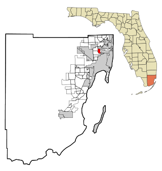
Pinewood is an unincorporated community and census-designated place (CDP) in Miami-Dade County, Florida, United States. It is part of the Miami metropolitan area of South Florida. The population was 17,246 at the 2020 census.

<span class="mw-page-title-main">Edgewood, Florida</span> City in Florida, United States

Edgewood is a city in Orange County, Florida, United States. It is part of the Orlando–Kissimmee–Sanford Metropolitan Statistical Area. The population was 2,685 at the 2020 census.

<span class="mw-page-title-main">Kenneth City, Florida</span> Town in the state of Florida, United States

Kenneth City is a town in southern Pinellas County, Florida, between St. Petersburg and Pinellas Park, United States. It is part of the Tampa–St. Petersburg–Clearwater Metropolitan statistical area (MSA), much more commonly known as the Tampa Bay area. The population was 5,047 at the 2020 US census.

<span class="mw-page-title-main">Varnell, Georgia</span> City in Georgia, United States

Varnell is a city in Whitfield County, Georgia, United States. It is part of the Dalton, Georgia Metropolitan Statistical Area. The population was 2,179 at the 2020 census.

<span class="mw-page-title-main">Bel Aire, Kansas</span> City in Sedgwick County, Kansas

Bel Aire is a city in Sedgwick County, Kansas, United States, and a suburb of Wichita. As of the 2020 census, the population of the city was 8,262.

<span class="mw-page-title-main">Colwich, Kansas</span> City in Sedgwick County, Kansas

Colwich is a city in Sedgwick County, Kansas, United States, located northwest of Wichita. As of the 2020 census, the population of the city was 1,455.

<span class="mw-page-title-main">Park City, Kansas</span> City in Sedgwick County, Kansas

Park City is a city in Sedgwick County, Kansas, United States and a suburb of Wichita. As of the 2020 census, the population of the city was 8,333.

<span class="mw-page-title-main">Leoti, Kansas</span> City in Wichita County, Kansas

Leoti is a city in and the county seat of Wichita County, Kansas, United States. As of the 2020 census, the population of the city was 1,475.

<span class="mw-page-title-main">Fairland, Maryland</span> Census-designated place in Maryland, United States

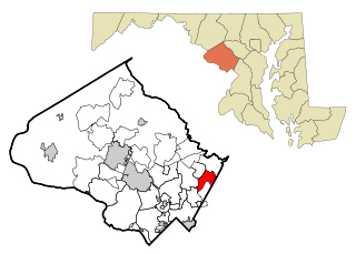
Fairland is a census-designated place and an unincorporated area in Montgomery County, Maryland, United States. It had a population of 25,396 per the 2020 census.

<span class="mw-page-title-main">Lauderdale, Minnesota</span> City in Minnesota, United States

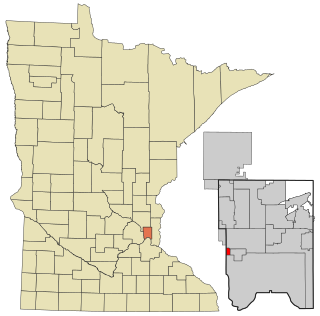
Lauderdale is a city in Ramsey County, Minnesota, United States. The population was 2,379 at the 2010 census. Lauderdale is part of the Minneapolis–St. Paul metropolitan area and is surrounded by Minneapolis, St. Paul, Roseville, and Falcon Heights. Along with Roseville, it is one of two cities to touch both Minneapolis and St Paul.

<span class="mw-page-title-main">Bel-Ridge, Missouri</span> City in Missouri, United States

Bel-Ridge is a suburban city in northern St. Louis County, Missouri, United States. The population was 2,737 at the 2010 census. Bel-Ridge is part of the Normandy Schools Collaborative. Bel-Ridge became a city in 2015 by a vote of the voters.

<span class="mw-page-title-main">Bellerive Acres, Missouri</span> City in Missouri, United States

Bellerive Acres is a northern suburban city in St. Louis County, Missouri, United States. The population was 188 at the 2010 census. In April, 2015, the residents voted to change the village of Bellerive to a fourth class city named Bellerive Acres.

<span class="mw-page-title-main">Black Jack, Missouri</span> City in Missouri, United States

Black Jack is a second-ring suburb of St. Louis, located in northern St. Louis County, Missouri, United States. The population was 6,929 at the 2010 census.

<span class="mw-page-title-main">Cool Valley, Missouri</span> City in Missouri, United States

Cool Valley is a city in St. Louis County, Missouri, United States in Greater St. Louis. The population was 1,196 at the 2010 census.

<span class="mw-page-title-main">Castle Point, Missouri</span> Place in Missouri, United States

Castle Point is an unincorporated community and census-designated place (CDP) in St. Louis County, Missouri, United States. The population was 3,962 at the 2010 census.

St. Bonaventure is a hamlet and census-designated place (CDP) in the town of Allegany in Cattaraugus County, New York, United States. The population was 1,963 at the 2020 census.

<span class="mw-page-title-main">Pleasant Valley, Texas</span> Town in Texas, United States

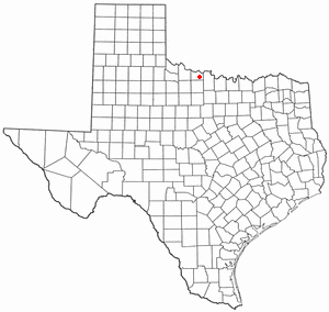
Pleasant Valley is a town in Wichita County, Texas, United States. It is part of the Wichita Falls, Texas metropolitan statistical area. The population was 336 at the 2010 census. Pleasant Valley is also referred to as "The rural country club of Wichita County", in part because of the high demand for land and above-average home prices. This includes Pleasant Valley estates and also Horseshoe Bend estates to the southwest.

<span class="mw-page-title-main">Northfork, West Virginia</span> Town in West Virginia, United States

Northfork is a town in McDowell County, West Virginia, United States, located on U.S. Route 52 between Welch and Bluefield.

Cincinnati is a city in Ohio, United States.

References

  1. 1 2 3 4 5 "U.S. Census website". United States Census Bureau . Retrieved November 12, 2011.
  2. United States Census Bureau. "Census of Population and Housing" . Retrieved August 18, 2014.
  3. "1960 Census of Population and Housing". United States Census Bureau. 1960. Retrieved January 1, 2010.
  4. "U.S. Census website". United States Census Bureau . Retrieved July 15, 2013.
  5. "Explore Census Data". data.census.gov. Retrieved December 15, 2023.
  6. "P1: Race – 2020: DEC Redistricting Data (PL 94-171) – Wichita city, Kansas". United States Census Bureau.
  7. "P2: Hispanic or Latino, and Not Hispanic or Latino by Race – 2020: DEC Redistricting Data (PL 94-171) – Wichita city, Kansas". United States Census Bureau.
  8. "Explore Census Data". data.census.gov. Retrieved December 15, 2023.
  9. 1 2 "OMB Bulletin No. 10-02" (PDF). Office of Management and Budget. December 1, 2009. p. 59. Archived (PDF) from the original on January 21, 2017. Retrieved January 22, 2011.
  10. "OMB Bulletin No. 10-02" (PDF). Office of Management and Budget. December 1, 2009. p. 117. Archived (PDF) from the original on January 21, 2017. Retrieved January 22, 2011.
  11. Thomas, G. Scott (2011). "Metro Area Populations as of July 2011: 2011 – United States – Metropolitan Statistical Area". 2011 American City Business Journals, Inc. American City Business Journals, Inc. Retrieved April 30, 2011.
  12. "Annual Estimates of the Population of Metropolitan and Micropolitan Statistical Areas: April 1, 2000 to July 1, 2009". 2009 Population Estimates. United States Census Bureau, Population Division. March 23, 2010. Archived from the original (CSV) on October 13, 2013. Retrieved March 29, 2010.
  13. "Population and Housing Occupancy Status: 2010 – United States – Combined Statistical Area". 2010 Census National Summary File of Redistricting Data. United States Census Bureau, Population Division. 2010. Archived from the original on February 12, 2020. Retrieved April 30, 2011.
  14. "Population and Housing Occupancy Status: 2010 – State – County / County Equivalent". 2010 Census Redistricting Data (Public Law 94-171) Summary File. United States Census Bureau . Retrieved April 30, 2011.[ dead link ]