Denizli

Last updated
Denizli
City
TR Denizli asv2020-02 img11 view from Teleferik viewpoint.jpg
View of the city from above
Denizli city emblem.png
Turkey relief location map.jpg
Red pog.svg
Denizli
Location of Denizli
Europe relief laea location map.jpg
Red pog.svg
Denizli
Denizli (Europe)
Asia laea relief location map.jpg
Red pog.svg
Denizli
Denizli (Asia)
Coordinates: 37°47′00″N29°05′47″E / 37.78333°N 29.09639°E / 37.78333; 29.09639
Country Flag of Turkey.svg  Turkey
Region Aegean Region
Province Denizli Province
Government
   Mayor Bülent Nuri Çavuşoğlu [1] (CHP)
Elevation
324 m (1,063 ft)
Population
 (2022) [2]
   Urban
651,200
Time zone UTC+3 (TRT)
Postal code
20x xx
Area code (0090) 258
Licence plate 20
Website www.denizli.bel.tr

Denizli is a city in Aegean Turkey, and seat of the province of Denizli. The city forms the urban part of the districts Merkezefendi and Pamukkale, with a population of 651,200 in 2022. [2]

Contents

Denizli has seen economic development in the last few decades, mostly due to textile production and exports. [3] [4]

Denizli also attracts visitors to the nearby mineral-coated hillside hot spring of Pamukkale, and with red color thermal water spa hotels Karahayıt, just 5 kilometres (3 miles) north of Pamukkale. Recently, Denizli became a major domestic tourism destination due to the various types of thermal waters in Sarayköy, Central/Denizli (where Karahayıt and Pamukkale towns are located), Akköy (Gölemezli), Buldan (Yenicekent), and Çardak districts.

The ancient ruined city of Hierapolis, as well as ruins of the city of Laodicea on the Lycus, the ancient metropolis of Phrygia, are nearby. Also in the vicinity of Honaz, about 10 mi (16 km) west of Denizli is, what was, in the 1st century AD, the city of Colossae.

The weather is hot in Denizli in summers, whereas in winters, it may occasionally be very cold with snow on the mountains that surround the city. Some years, snow can be observed in the urban areas. Springs and autumns are rainy, with a mild warm climate.

Name

The word deniz means 'sea, large lake'. No sea or lake can be found near Denizli. However, the original Turkish name for the place was Tonguzlu, pronounced as toŋuzlu or doŋuzlu, later donuzlu (from toŋuz 'wild boar'). Thus Tonguzlu means a 'place where boars dwell'. Because of the phonetical process (t->d, ŋ->n), the name was changed into denizlü or denizli, similar in pronunciation but different in meaning, in order to avoid the connotation 'boar, pig', which is considered offensive in Islam. [5] Ibn Battuta recorded that the city was called Dun Ghuzluh. The latter is said to mean 'the town of the swine'. [6]

History

Pamukkale is a main tourism attraction in Denizli. Pamukkale 30.jpg
Pamukkale is a main tourism attraction in Denizli.
Archaeological site of Laodicea on the Lycus between Pamukkale and Denizli, Turkey. The photo shows the Syria Street. TR Pamukkale Laodicea asv2020-02 img11.jpg
Archaeological site of Laodicea on the Lycus between Pamukkale and Denizli, Turkey. The photo shows the Syria Street.

In antiquity, it was an important Greek town, called Attouda (Αττούδα), that existed through the ancient Greek and Roman eras; it was near the cities (Hierapolis and Laodicea on the Lycus) and flourished through the Byzantine period.

The city was conquered by the Seljuk Turks. Inhabitants of Laodicea were also resettled here in the Seljuk period. [7]

Ibn Battuta visited the city, noting that "In it there are seven mosques for the observance of Friday prayers, and it has splendid gardens, perennial streams, and gushing springs. Most of the artisans there are Greek women, for in it are many Greeks who are subject to the Turks and who pay dues to the sultan, including the jizya , and other taxes." [8]

In the 17th century, the Ottoman traveller Evliya Çelebi visited Denizli and recorded the town as follows: "The city is called by Turks as (Denizli) (which means has abundant of water sources like sea in Turkish) as there are several rivers and lakes around it. In fact it is a four-day trip from the sea. Its fortress is of square shape built on flat ground. It has no ditches. Its periphery is 470 steps long. It has four gates. These are: painters gate in North, saddle-makers gate in the East, new Mosque gate in the South, and vineyard gate in the West. There are some fifty armed watchmen in the fortress, and they attend the shop. The main city is outside the fortress with 44 districts and 3600 houses. There are 57 small and large mosques and district mosques, 7 madrasahs, 7 children's schools, 6 baths and 17 dervish lodges. As everybody lives in vineyards the upper classes and ordinary people do not flee from each other."[ citation needed ]

The city lived in peace for centuries without being involved in wars in a direct manner. Following World War I, during the Turkish War of Independence, the Greek Army managed to capture and come as close as Sarayköy, a small town 20 km (12 mi) northwest of Denizli, but did not venture into Denizli. They were then ousted from the region by Mustafa Kemal Pasha. The most widespread symbols of Denizli province are of textile industry.

Climate

Denizli has a Mediterranean climate (Köppen: Csa or Trewartha: Cs), with hot, dry summers and mild to cool, rainy winters. The inland areas, like Çardak, Bozkurt, Çivril, and Çal districts/counties of the province are cooler and have a higher elevation than the seaside, western part of the Province. Therefore, there are climatic differences within the province and even in the Denizli urbanized area.[ citation needed ] The land is open to winds coming from the Aegean Sea as the mountains are perpendicular to the coastline.

Climate data for Denizli (1991–2020, extremes 1957–2020)
MonthJanFebMarAprMayJunJulAugSepOctNovDecYear
Record high °C (°F)22.6
(72.7)
25.9
(78.6)
30.8
(87.4)
35.8
(96.4)
39.5
(103.1)
44.1
(111.4)
43.9
(111.0)
44.4
(111.9)
41.6
(106.9)
36.9
(98.4)
29.9
(85.8)
26.6
(79.9)
44.4
(111.9)
Mean daily maximum °C (°F)10.7
(51.3)
12.7
(54.9)
16.5
(61.7)
21.3
(70.3)
27.0
(80.6)
32.3
(90.1)
35.7
(96.3)
35.7
(96.3)
31.0
(87.8)
24.7
(76.5)
17.8
(64.0)
12.2
(54.0)
23.1
(73.6)
Daily mean °C (°F)6.2
(43.2)
7.6
(45.7)
10.7
(51.3)
15.1
(59.2)
20.2
(68.4)
25.1
(77.2)
28.3
(82.9)
28.2
(82.8)
23.5
(74.3)
17.9
(64.2)
11.9
(53.4)
7.7
(45.9)
16.9
(62.4)
Mean daily minimum °C (°F)2.7
(36.9)
3.6
(38.5)
6.0
(42.8)
9.7
(49.5)
14.2
(57.6)
18.6
(65.5)
21.6
(70.9)
21.5
(70.7)
17.2
(63.0)
12.5
(54.5)
7.5
(45.5)
4.4
(39.9)
11.6
(52.9)
Record low °C (°F)−10.5
(13.1)
−11.4
(11.5)
−7.0
(19.4)
−2.0
(28.4)
2.7
(36.9)
7.9
(46.2)
12.6
(54.7)
11.6
(52.9)
6.6
(43.9)
−0.8
(30.6)
−4.5
(23.9)
−10.4
(13.3)
−11.4
(11.5)
Average precipitation mm (inches)85.7
(3.37)
69.7
(2.74)
63.8
(2.51)
54.8
(2.16)
47.9
(1.89)
31.8
(1.25)
16.3
(0.64)
12.1
(0.48)
15.7
(0.62)
37.1
(1.46)
57.8
(2.28)
81.1
(3.19)
573.8
(22.59)
Average precipitation days11.7010.9311.2310.079.675.772.932.833.576.707.6712.1795.2
Average relative humidity (%)71.367.663.058.754.146.841.643.348.558.765.371.657.5
Mean monthly sunshine hours 111.6130.0173.6207.0272.8321.0359.6325.5264.0207.7147.0102.32,622.1
Mean daily sunshine hours 3.64.65.66.98.810.711.610.58.86.74.93.37.2
Source 1: Turkish State Meteorological Service [9]
Source 2: NOAA (humidity, 1991–2020) [10]

Denizli today

Economy

Denizli Museum TR Denizli asv2020-02 img03 Ethnography Museum.jpg
Denizli Museum
View of Denizli from a hill TR Denizli asv2020-02 img11 view from Teleferik viewpoint.jpg
View of Denizli from a hill
Rooster is the symbol of the city TR Denizli asv2020-02 img13 The Rooster.jpg
Rooster is the symbol of the city
Gazi Mustafa Kemal Elementary School TR Denizli asv2020-02 img14 Gazi School.jpg
Gazi Mustafa Kemal Elementary School

During World War I, Denizli mined chromium. [11]

Transportation

Denizli Çardak Airport is about 45 minutes drive from the city center.

The extension of İzmir-Aydın highway to Denizli has been announced for several years. Initial infrastructure was laid in Aydın, but the rest is still forthcoming. The present Aydın-Denizli road, has a very high level of traffic, especially trucks, with each town along the road possessing its own industrial zone.

Places of interest

Lower station of the cableway (Teleferik) in Denizli TR Denizli asv2020-02 img04 Teleferik.jpg
Lower station of the cableway (Teleferik) in Denizli
Denizli Railway Station TR Denizli asv2020-02 img01 railway station.jpg
Denizli Railway Station

Notable people

Ancient sites of Denizli

Twin towns – sister cities

Sign with sister cities (2009 state) Denizli kardes sehirler.jpg
Sign with sister cities (2009 state)

Denizli is twinned with: [12]

Denizli also cooperates with Bursa and Tokat in Turkey. [12]

See also

Related Research Articles

<span class="mw-page-title-main">Denizli Province</span> Province of Turkey

Denizli Province is a province and metropolitan municipality of Turkey in Western Anatolia, on high ground above the Aegean coast. Neighbouring provinces are Uşak to the north, Burdur, Isparta, Afyon to the east, Aydın, Manisa to the west and Muğla to the south. It is located between the coordinates 28° 30’ and 29° 30’ E and 37° 12’ and 38° 12’ N. Its area is 12,134 km2, and its population is 1,056,332 (2022). The provincial capital is the city of Denizli.

<span class="mw-page-title-main">Pamukkale</span> Natural site in Denizli Province in southwestern Turkey

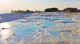
Pamukkale, meaning "cotton castle" in Turkish, is a natural site in Denizli Province in southwestern Turkey. The area is famous for a carbonate mineral left by the flowing of thermal spring water. It is located in Turkey's Inner Aegean region, in the River Menderes valley, which has a temperate climate for most of the year.

<span class="mw-page-title-main">Selçuk</span> District and municipality in İzmir, Turkey

Selçuk is a municipality and district of İzmir Province, Turkey. Its area is 317 km2, and its population is 38,151 (2022). The town Selçuk is located 2 kilometres northeast of the ancient city of Ephesus, that was once home to the Temple of Artemis, one of the Seven Wonders of the Ancient World.

<span class="mw-page-title-main">Burdur</span> Municipality in Turkey

Burdur is a city in southwestern Turkey. The seat of Burdur Province and of Burdur District, it is located on the shore of Lake Burdur. Its population is 95,436 (2021).

<span class="mw-page-title-main">Laodicea on the Lycus</span> Ancient town in Phrygia, Asia Minor, now Turkey

Laodicea on the Lycus was a rich ancient city in Asia Minor, now Turkey, on the river Lycus (Çürüksu). It was located in the Hellenistic regions of Caria and Lydia, which later became the Roman Province of Phrygia Pacatiana. It is now near the modern city of Denizli.

<span class="mw-page-title-main">Çal</span> District and municipality in Denizli, Turkey

Çal is a municipality and district of Denizli Province, Turkey. Its area is 860 km2, and its population is 17,889 (2022). Çal district area occupies a central position in the northern part of its province and neighbors the district of Pamukkale to the south-west and the district areas of Güney to the west and Honaz to the south. To the east of Çal district lies clockwise the districts of Bekilli, Çivril and Baklan.

<span class="mw-page-title-main">Honaz</span> District and municipality in Denizli, Turkey

Honaz is a municipality and district of Denizli Province, Turkey. Its area is 449 km2, and its population is 34,074 (2022).

<span class="mw-page-title-main">Sarayköy</span> District and municipality in Denizli, Turkey

Sarayköy is a municipality and district of Denizli Province, Turkey. Its area is 379 km2, and its population is 30,834 (2022). It is 20 km west of the city of Denizli, on a plain between mountains and watered by Büyük Menderes River.

<span class="mw-page-title-main">Sultanhisar</span> District and municipality in Aydın, Turkey

Sultanhisar is a municipality and district of Aydın Province, Turkey. Its area is 220 km2, and its population is 20,230 (2022). It is 30 km east of the city of Aydın on the road to Denizli.

<span class="mw-page-title-main">Acıpayam</span> District and municipality in Denizli, Turkey

Acıpayam is a municipality and district of Denizli Province, Turkey. Its area is 1,772 km2, and its population is 54,888 (2022). It lies in high country between the Aegean and Mediterranean regions. A plain, watered by two reservoirs, known for growing melons and watermelons, on the road between the city of Denizli and Antalya. Its altitude is 895 m.

<span class="mw-page-title-main">Bozkurt, Denizli</span> District and municipality in Denizli, Turkey

Bozkurt is a municipality and district of Denizli Province, Turkey. Its area is 462 km2, and its population is 12,331 (2022). The town is situated on a plain 52 km (32 mi) east of the city of Denizli. The altitude of the town is 867 m. It is quite close to the Lake Acıgöl and the neighboring town of Çardak and İnceler Kasabası

<span class="mw-page-title-main">Buldan</span> District and municipality in Denizli, Turkey

Buldan is a municipality and district of Denizli Province, Turkey. Its area is 523 km2, and its population is 26,630 (2022). Buldan district area neighbors to the east and the south three other districts of the same province, namely Güney, Pamukkale and Sarayköy, and to the west by the areas of three districts of Aydın Province, Buharkent, Kuyucak and Karacasu, and to the northwest by Sarıgöl district of Manisa Province.

<span class="mw-page-title-main">Hierapolis</span> Ancient Greek city

Hierapolis was originally a Phrygian cult centre of the Anatolian mother goddess of Cybele and later a Greek city. Its location was centred upon the remarkable and copious hot springs in classical Phrygia in southwestern Anatolia. Its extensive remains are adjacent to modern Pamukkale in Turkey.

<span class="mw-page-title-main">Aegean Region</span> Region of Turkey

The Aegean Region is one of the 7 geographical regions of Turkey. The largest city in the region is İzmir. Other big cities are Manisa, Aydın, Denizli, Muğla, Afyonkarahisar and Kütahya.

Attuda or Attouda was a Hellenistic city in ancient Caria and later in the Roman province of Phrygia Pacatiana. There are coins of the place with the Greek epigraph Ἱερὰ Βουλὴ Ἀττουδέων, of the time of Augustus and later. The coins show that the Men Carus was worshipped there.

<span class="mw-page-title-main">Birgi</span> Neighbourhood in Ödemiş, İzmir, Turkey

Birgi is a neighbourhood in the municipality and district of Ödemiş, İzmir Province, Turkey. Its population is 1,832 (2022). Before the 2013 reorganisation, it was a town (belde). Its current name is a corruption of its medieval Greek name, Pyrgion.

Kaklık is a neighbourhood of the municipality and district of Honaz, Denizli Province, Turkey. Its population is 4,909 (2022). Before the 2013 reorganisation, it was a town (belde).

<span class="mw-page-title-main">Ploutonion at Hierapolis</span> Ancient shrine to god Pluto in Turkey

The Ploutonion at Hierapolis or Pluto's Gate was a ploutonion in the ancient city of Hierapolis near Pamukkale in modern Turkey's Denizli Province. The site was discovered in 1965 by Italian archaeologists, who published reports on their excavations throughout the decade. Following the studies carried out on site in 1998, a geologist of the Italian National Research Council, Luigi Piccardi, recognized that the origin of both the Ploutonion and of the nearby Apollo's Oracle of Hierapolis was linked to the existence of the surface trace of a seismic fault, on which both sanctuaries were purposely built and which was revered as Gateway of Hades. In 2013, it was further explored by Italian archaeologists led by Francesco D'Andria, a professor of archaeology at the University of Salento. As part of a restoration project, a replica of the marble statue of Hades and Cerberus has been restored to its original place. The statue is known to have been there in ancient times.

The 1899 Aydın–Denizli earthquake which struck present-day Turkey on September 30 resulted in between 1,117 and 1,470 fatalities. Heavy damage was reported in the provinces of Aydın and Denizli. The shallow normal-faulting earthquake had a maximum Modified Mercalli intensity of IX (Violent). Estimates of the seismic magnitude range from 6.5 to 7.1 Mw.

References

  1. "Özgeçmişi". Archived from the original on 2020-01-31. Retrieved 2020-10-05.
  2. 1 2 "Denizli". citypopulation.de. Retrieved 26 January 2024.
  3. Bernard Fingleton; Ayda Eraydın; Raffaele Paci; Bilge Armatlı Köroğlu; Burak Beyhan (2003). Regional Economic Growth, SMEs and the Wider Europe, Chapter 11: The changing role of SMEs in the regional growth process: The case of Denizli. Ashgate Publishing. p. 229. ISBN   0-7546-3613-5.
  4. Hüseyin Özgür, Pamukkale University. "Integration of a Local Economy to the Global and European Markets through Export–Led Growth and Specialized Textile Products Export: Home Textile Production in Denizli – Turkey" (PDF). University of Łódź. Archived from the original (PDF) on 2007-06-30. Retrieved 2007-04-18.
  5. Dimitri Korobeinikov (2014). Byzantium and the Turks in the Thirteenth Century. p. 223.
  6. Colin J. Hemer (1987). Letters to the Seven Churches of Asia In their Local Setting. p. 277.
  7. John Freely, The western shores of Turkey: discovering the Aegean and Mediterranean coasts, 2004. ISBN   1-85043-618-5. p. 182.
  8. Battutah, Ibn (2002). The Travels of Ibn Battutah. London: Picador. pp. 105, 309. ISBN   9780330418799.
  9. "Resmi İstatistikler: İllerimize Ait Mevism Normalleri (1991–2020)" (in Turkish). Turkish State Meteorological Service. Archived from the original on 2 May 2021. Retrieved 1 May 2021.
  10. "World Meteorological Organization Climate Normals for 1991–2020". World Meteorological Organization. Archived from the original on 17 July 2021. Retrieved 2 August 2023.
  11. Prothero, G.W. (1920). Anatolia. London: H.M. Stationery Office. p. 104. Archived from the original on 2013-10-15. Retrieved 2013-09-06.
  12. 1 2 "Denizli Municipality City Health Profile" (PDF). skb.gov.tr. Türkiye Sağlıklı Kentler Birliği. February 2010. p. 160. Retrieved 2024-01-12.