
Wrightsville Beach is a town in New Hanover County, North Carolina, United States. Wrightsville Beach is just east of Wilmington and is part of the Wilmington Metropolitan Statistical Area. The population was 2,477 at the 2010 census. The town consists of a 4-mile (6 km) long beach island, an interior island called Harbor Island, and pockets of commercial property on the mainland. It served as a filming location of Dawson's Creek.

A pier is a raised structure that rises above a body of water and usually juts out from its shore, typically supported by piles or pillars, and provides above-water access to offshore areas. Frequent pier uses include fishing, boat docking and access for both passengers and cargo, and oceanside recreation. Bridges, buildings, and walkways may all be supported by architectural piers. Their open structure allows tides and currents to flow relatively unhindered, whereas the more solid foundations of a quay or the closely spaced piles of a wharf can act as a breakwater, and are consequently more liable to silting. Piers can range in size and complexity from a simple lightweight wooden structure to major structures extended over 1,600 m (5,200 ft). In American English, a pier may be synonymous with a dock.

The Phi Phi Islands are an island group in Thailand between the large island of Phuket and the Straits of Malacca coast of Thailand. The islands are administratively part of Krabi Province. Ko Phi Phi Don is the largest and most populated island of the group, although the beaches of the second largest island, Ko Phi Phi Le are visited by many people as well. The rest of the islands in the group, including Bida Nok, Bida Nai, and Ko Mai Phai, are not much more than large limestone rocks jutting out of the sea. The islands are reachable by ferries, speedboats or long-tail boats, most often from Krabi town or from ports in Phuket Province.

Tung Ping Chau is an island in Hong Kong, part of Hong Kong UNESCO Global Geopark. It is also known as Ping Chau (平洲). Tung is prepended to the name at times so as to avoid possible confusion with Peng Chau, another island in Hong Kong with an identically pronounced name in Cantonese. Administratively, the island is part of the Tai Po District in the New Territories.

Chebeague Island is located in Casco Bay, an inlet of the Gulf of Maine. It was originally used as a fishing ground by Abenaki Native Americans. Also known as Great Chebeague Island, today it is a town in Cumberland County, Maine, United States. It is located 10 miles (16 km) northeast of Portland, Maine. Chebeague Island is the largest island in Casco Bay that is not connected to the mainland by a bridge. The largest island is Sebascodegan, or "Great Island," which is part of the Town of Harpswell and connected to the mainland via a 100ft bridge.
Tablas is the largest of the islands that comprise the province of Romblon in the Philippines. The name of the island was of Spanish origin. Before the colonization of the Philippines, Tablas was known as the Island of Osigan. At the time of contact with Westerners, Osigan had a population of two hundred and fifty people living in small villages. Wax was produced in this island.

Anderson Island is the southernmost island in Puget Sound and a census-designated place of Pierce County, Washington, United States. It is accessible by boat or a 20-minute ferry ride from Steilacoom. Anderson Island is just south of McNeil Island. To the northwest, Key Peninsula is across Drayton Passage. The south basin of Puget Sound separates the island from the mainland to the southeast, while to the southwest the Nisqually Reach of Puget Sound separates the island from the mainland.

A sea tractor is a motor vehicle designed to travel through shallow seawater, carrying passengers on a platform elevated above a submerged chassis. The sea tractor was most popular during the early 1930s, as a unique way to give scenic tours to patrons of waterfront hotels and resorts. In other applications, sea tractors were used simply as a ferry through shallow waters. The use of sea tractors has declined since, as boats, ferries, and other aquatic vessels often serve the same function much more efficiently and comfortably.

Egmont Key National Wildlife Refuge and State Park is a National Wildlife Refuge and State Park located on the island of Egmont Key, at the mouth of Tampa Bay. Egmont Key lies southwest of Fort De Soto Park and can only be reached by boat or ferry. Located within Egmont Key National Wildlife Refuge and State Park are the 1858 Egmont Key Lighthouse, maintained by the U.S. Coast Guard, and the ruins of Fort Dade, a Spanish–American War era fort that housed 300 residents. Egmont Key is located in Hillsborough County Florida on a narrow strip of the county that extends along the Tampa Port Shipping Channel.
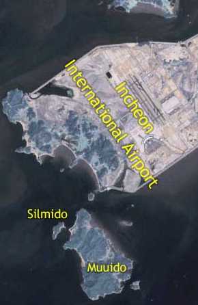
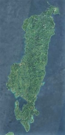
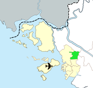
Muuido, also known as Muui Island, is an island in South Korea. It is a small island located south of Yongyu Island, which was joined with Yeongjong Island when Incheon International Airport was built. Muui Island measures 5.2 kilometres (3.2 mi) long and 4.5 kilometres (2.8 mi) wide. The island is visible from the airport.

Yeongjong Island is an island off the west coast of the city of Incheon, South Korea, which contains Incheon International Airport as well as small villages, farms, and beaches. The previously separate Yongyu, Sammok, and Sinbul Islands have been joined to Yeongjong Island by an area of reclaimed land built for the construction of the airport. The island is an exclave of Incheon Metropolitan City's Jung-gu district, and is accessed via two bridges, Yeongjong Bridge connecting to Seo-gu and Incheon Bridge connecting to Songdo.

Tropical Storm Danielle was a strong tropical storm that made landfall on Virginia in the 1992 Atlantic hurricane season. The fourth storm of the season, Danielle was one of two tropical cyclones in the year to make landfall in the United States, the other being Hurricane Andrew. It formed out of a stationary trough of low pressure on September 18 near the coast of North Carolina. The system quickly reached tropical storm status, and Danielle looped to the west due to a change in steering currents. Tropical Storm Danielle reached a peak of 65 mph (105 km/h) winds before weakening and hitting the Delmarva Peninsula. The storm quickly dissipated over land.

Ongjin County (Korean: 옹진군) is a county in Incheon Metropolitan City, South Korea. It consists of a group of islands in the Yellow Sea.

Gills Bay, which is situated about 3 mi (4.8 km) west of John o' Groats with the community of Gills close by, has one of the longest stretches of low-lying rock coast on the northern shores of Caithness. Its main features are a small harbour and the pier used as the mainland terminal for Pentland Ferries. The harbour shelters some small local boats together with those used for working the sheep on the off lying island of Stroma. In the right sea conditions the area is sometimes used for surfing.
Tavewa is an island of the Yasawa Islands, measuring approximately 3 kilometres long by 1 km wide. It is part of the Nacula District that lies north-west of the Fijian island of Viti Levu.
Gyeyang District is a ward in Incheon, South Korea.

Bupyeong District is one of the 10 administrative divisions that comprise Incheon, South Korea. Bupyeong-gu comprises an area of 12.35 square miles, and has a population of 508,587. It is located north of Namdong-gu, east of Seo-gu, and south of Gyeyang-gu. The city of Bucheon, in neighboring Gyeonggi Province, comprises its eastern limit.

Yeongheung Island is an island in the Yellow Sea, within the municipal borders of Incheon metropolitan city. It has a population of roughly 4000 people and an area of 23.46 km². The island is connected by road to neighbouring Seonjae-do (Hangeul:선재도) by the 1.25 km-long Yeongheung Bridge, which opened in December 2001. Administratively, the island today is divided into ten li: Nae-ri (내리) 1 to 7, and Oi-ri (외리) 1 to 3. Employment is provided through tourism, fishing, and the thermoelectric power station, largely built on reclaimed land on the south-west coast of the island.
Koh Rong Sanloem is an island off the coast of Sihanoukville, Cambodia, 4 km (2 mi) south of Koh Rong. It is around 9 km (6 mi) long, 4 km (2 mi) wide and 1 km (1 mi) wide at its narrowest point. Its distance from the local port of Sihanoukville is 25 km (16 mi) (beeline) and 23 km (14 mi) (beeline) from the Serendipity/Ochheuteal beach pier. The word "Sanloem" translates to: 1. drowsiness and to: 2. far out and hard to discern, in a wider sense. Inconsistencies on how to spell the island's name in its Latinized version date back to the 19th century. The first controversial spelling variants were issued by map makers during French rule. Alternatives have since become widespread and are in common usage. Often confusion ensues as Google Maps offers the phonetically most consistent variant, whereas Google Search redirects to an alternative.
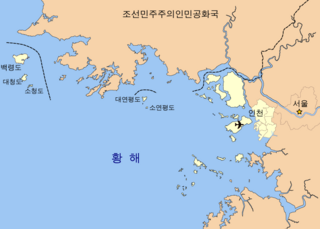
The Five West Sea Islands refers to the five islands in the West Sea administered by Incheon, South Korea. They are Yeonpyeongdo, Baengnyeongdo, Daecheongdo, Socheongdo and Soyeonpyeongdo. Their positions are much closer to North Korea as these islands are originally part of Hwanghae Province and their sovereignties are claimed by North Korea, but they are controlled by South Korea since the United Nations forces established the Northern Limit Line (NLL) north of the islands in 1953 following the Korean War.
