Desert Hills, Arizona

Last updated

Desert Hills, Arizona
Mohave County Incorporated and Unincorporated areas Desert Hills highlighted.svg
Location in Mohave County and the state of Arizona
USA Arizona location map.svg
Red pog.svg
Desert Hills
Usa edcp location map.svg
Red pog.svg
Desert Hills
Coordinates: 34°32′51″N114°22′0″W / 34.54750°N 114.36667°W / 34.54750; -114.36667
Country United States
State Arizona
County Mohave
Area
[1]
  Total4.90 sq mi (12.68 km2)
  Land4.31 sq mi (11.15 km2)
  Water0.59 sq mi (1.53 km2)
Elevation
542 ft (165 m)
Population
 (2020) [2]
  Total2,764
  Density641.90/sq mi (247.84/km2)
Time zone UTC-7 (MST)
ZIP code
86404 [3]
Area code 928
FIPS code 04-18740
GNIS feature ID 1866982

Desert Hills is an unincorporated community and census-designated place (CDP) in Mohave County, Arizona, United States. The population was 2,764 at the 2020 census, [2] up from 2,245 at the 2010 census.

Contents

Geography

Desert Hills is located in western Mohave County at 34°32′51″N114°22′0″W / 34.54750°N 114.36667°W / 34.54750; -114.36667 (34.547363, -114.366781). [4] It is sits on the east side of the Colorado River, impounded as Lake Havasu. The CDP is bordered to the south and east by Lake Havasu City, to the north by Crystal Beach, and to the west, across the Colorado, by San Bernardino County, California. Arizona State Route 95 runs along the eastern edge of the CDP, leading south 4 miles (6 km) to the center of Lake Havasu City and north 18 miles (29 km) to Interstate 40.

According to the United States Census Bureau, the Desert Hills CDP has a total area of 4.9 square miles (13 km2), of which 4.3 square miles (11 km2) are land and 0.6 square miles (1.6 km2), or 12.07%, are on the waters of Lake Havasu.

Demographics

Historical population
CensusPop.Note
2000 2,183
2010 2,2452.8%
2020 2,76423.1%
U.S. Decennial Census [5]

As of the census [6] of 2000, there were 2,183 people, 997 households, and 677 families living in the CDP. The population density was 463.8 inhabitants per square mile (179.1/km2). There were 1,463 housing units at an average density of 310.8 per square mile (120.0/km2). The racial makeup of the CDP was 93.1% White, 0.1% Black or African American, 0.6% Native American, 0.4% Asian, 4.4% from other races, and 1.4% from two or more races. 9.3% of the population were Hispanic or Latino of any race.

There were 997 households, out of which 17.8% had children under the age of 18 living with them, 55.7% were married couples living together, 7.5% had a female householder with no husband present, and 32.0% were non-families. 25.2% of all households were made up of individuals, and 12.8% had someone living alone who was 65 years of age or older. The average household size was 2.19 and the average family size was 2.54.

In the CDP, the population was spread out, with 16.6% under the age of 18, 5.0% from 18 to 24, 19.9% from 25 to 44, 31.1% from 45 to 64, and 27.4% who were 65 years of age or older. The median age was 52 years. For every 100 females, there were 99.7 males. For every 100 females age 18 and over, there were 99.5 males.

The median income for a household in the CDP was $26,678, and the median income for a family was $32,685. Males had a median income of $21,690 versus $20,433 for females. The per capita income for the CDP was $14,322. About 10.5% of families and 14.1% of the population were below the poverty line, including 14.4% of those under age 18 and 11.0% of those age 65 or over.

Education

It is in the Lake Havasu Unified School District, [7] which operates Lake Havasu High School.

Related Research Articles

<span class="mw-page-title-main">Mohave County, Arizona</span> County in Arizona, United States

Mohave County is in the northwestern corner of the U.S. state of Arizona. As of the 2020 census, its population was 213,267. The county seat is Kingman, and the largest city is Lake Havasu City. It is the fifth largest county in the United States.

<span class="mw-page-title-main">Cibola, Arizona</span> CDP in La Paz County, Arizona

Cibola is a census-designated place (CDP) in La Paz County, Arizona, United States. The population was 250 at the 2010 census, up from 172 in 2000. It is named for the famed city of gold of the same name.

<span class="mw-page-title-main">Parker Strip, Arizona</span> CDP in La Paz County, Arizona

Parker Strip is a census-designated place (CDP) in La Paz County, Arizona, United States. The population was 662 at the 2010 census.

<span class="mw-page-title-main">Arizona Village, Arizona</span> Census-designated place in Arizona, United States

Arizona Village is a census-designated place (CDP) on the Fort Mojave Indian Reservation in Mohave County, Arizona, United States. The population was 1,057 at the 2020 census, up from 946 in 2010 and 351 in 2000.

<span class="mw-page-title-main">Dolan Springs, Arizona</span> CDP in Mohave County, Arizona

Dolan Springs is an unincorporated community and census-designated place (CDP) in Mohave County, Arizona, United States. The population was 1,989 at the 2020 census, down from 2,033 at the 2010 census.

<span class="mw-page-title-main">Golden Valley, Arizona</span> CDP in Mohave County, Arizona

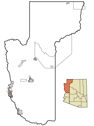
Golden Valley is an unincorporated area and census-designated place (CDP) in Mohave County, Arizona, United States. The population was 8,801 at the 2020 census.

<span class="mw-page-title-main">Lake Havasu City, Arizona</span> City in Mohave County, Arizona

Lake Havasu City is a city in Mohave County, Arizona, United States. As of the 2020 census, the population of the city was 57,144, up from 52,527 in 2010. It is served by Lake Havasu City Airport.

<span class="mw-page-title-main">Mesquite Creek, Arizona</span> CDP in Mohave County, Arizona

Mesquite Creek is an unincorporated community and census-designated place (CDP) in Mohave County, Arizona, United States. The population was 403 at the 2020 census.

<span class="mw-page-title-main">Mohave Valley, Arizona</span> CDP in Mohave County, Arizona

Mohave Valley is an unincorporated community and census-designated place (CDP) in Mohave County, Arizona, United States. The population was 2,693 at the 2020 census. It is geographically connected to Needles, California, Fort Mohave and Bullhead City.

<span class="mw-page-title-main">Mojave Ranch Estates, Arizona</span> CDP in Mohave County, Arizona

Mojave Ranch Estates is an unincorporated community and census-designated place (CDP) in Mohave County, Arizona, United States. The population was 53 as of the 2020 census.

<span class="mw-page-title-main">New Kingman-Butler, Arizona</span> CDP in Mohave County, Arizona

New Kingman-Butler is an unincorporated community and census-designated place (CDP) in Mohave County, Arizona, United States, directly north of and bordering the city of Kingman. The population was 12,907 as of the 2020 census.

<span class="mw-page-title-main">Peach Springs, Arizona</span> CDP in Mohave County, Arizona

Peach Springs is a census-designated place (CDP) in Mohave County, Arizona, United States. The population was 1,098 at the 2020 census. Peach Springs serves as the administrative headquarters of the Hualapai people and is located on the Hualapai Reservation.

<span class="mw-page-title-main">Willow Valley, Arizona</span> Census-designated place in Arizona, United States

Willow Valley is an unincorporated community and census-designated place (CDP) in Mohave County, Arizona, United States. The population was 1,059 as of the 2020 census.

<span class="mw-page-title-main">Cordes Lakes, Arizona</span> CDP in Yavapai County, Arizona

Cordes Lakes is a census-designated place (CDP) in Yavapai County, Arizona, United States. The population was 2,058 at the 2000 census. The Agua Fria National Monument lies to the east and south of the community and Arcosanti is to the north.

<span class="mw-page-title-main">Shady Hills, Florida</span> CDP in Florida, United States

Shady Hills is a census-designated place (CDP) in Pasco County, Florida, United States. The population was 7,798 at the 2000 census. It is in the Tampa-St. Petersburg-Clearwater, Florida Metropolitan Statistical Area and home to a pigeon racing group.

<span class="mw-page-title-main">Grand Canyon West, Arizona</span> Census-designated place in Arizona, United States

Grand Canyon West is a census-designated place (CDP) in Mohave County, Arizona, United States, located on the Hualapai Reservation. The population was reported as 0 at the 2020 census. Grand Canyon West is home to the tribe's Grand Canyon business operations, including the Grand Canyon West Airport and the Grand Canyon Skywalk. Typically, they are open from 8:00 a.m. – 6:00 p.m., including all holidays.

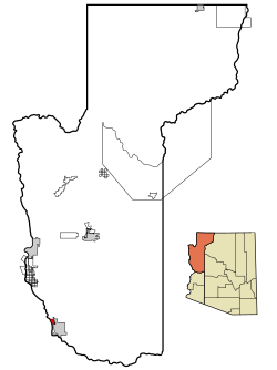
Crystal Beach is an unincorporated community in Mohave County, Arizona, United States. The population was 250 at the 2020 census. For statistical purposes, the United States Census Bureau has defined Crystal Beach as a census-designated place (CDP).

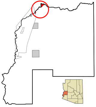
Golden Shores is a census-designated place (CDP) in Mohave County, Arizona, United States. The population was 1,927 at the 2020 census. Residents are part of the 86436 ZIP code area, with a mailing address of Topock.

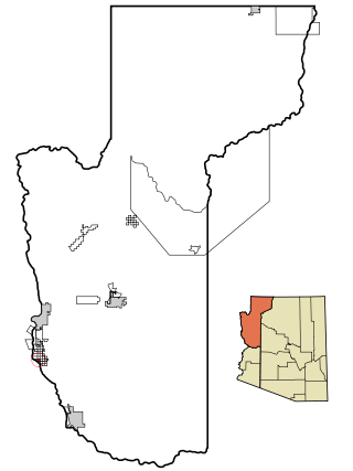
Katherine is an unincorporated community and census-designated place (CDP) in Mohave County, Arizona, United States. The population was 76 at the 2020 census, down from 103 at the 2010 census.

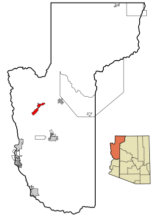
Pine Lake is an unincorporated community and census-designated place (CDP) in Mohave County, Arizona, United States. The population was 142 at the 2020 census.

References

  1. "2021 U.S. Gazetteer Files: Arizona". United States Census Bureau. Retrieved May 20, 2022.
  2. 1 2 "Desert Hills CDP, Arizona: 2020 DEC Redistricting Data (PL 94-171)". U.S. Census Bureau. Retrieved May 20, 2022.
  3. "Desert Hills AZ ZIP Code". zipdatamaps.com. 2023. Retrieved January 26, 2023.
  4. "US Gazetteer files: 2010, 2000, and 1990". United States Census Bureau. February 12, 2011. Retrieved April 23, 2011.
  5. "Census of Population and Housing". Census.gov. Retrieved June 4, 2016.
  6. "U.S. Census website". United States Census Bureau . Retrieved January 31, 2008.
  7. "2020 CENSUS - SCHOOL DISTRICT REFERENCE MAP: Mohave County, AZ" (PDF). U.S. Census Bureau. p. 3 (PDF p. 4/4). Retrieved January 9, 2023.