The Westwoods Trails is an extensive hiking trail system in Guilford, Connecticut. The trail system has approximately 39 miles (63 km) of trails with features including caves, lakes, streams, rivers, and interesting rock formations. The preserve extends across land owned by the Guilford Land Conservation Trust, which also owns many other land parcels across the town which provide hiking trails, and the State of Connecticut. The trails are accessible for walking, running, and mountain biking. Hunting is only allowed on state land during the season.

Devil's Millhopper Geological State Park is a Florida State Park located in the north-westernmost part of Gainesville, Florida, off County Road 232, northwest of the University of Florida.
The Potomac Highlands of West Virginia centers on five West Virginian counties in the upper Potomac River watershed in the western portion of the state's Eastern Panhandle, bordering Maryland and Virginia. Because of geographical proximity, similar topography and landscapes, and shared culture and history, the Potomac Highlands region also includes Pocahontas, Randolph, and Tucker counties, even though they are in the Monongahela River or New River watersheds and not that of the Potomac River.
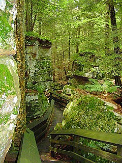
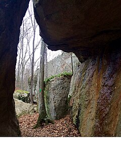
Beartown State Park is a 110-acre (45 ha) state park located on the eastern summit of Droop Mountain, 7 miles (11 km) southwest of Hillsboro, West Virginia, in northern Greenbrier County, West Virginia. The land was purchased in 1970 with funds from the Nature Conservancy and a donation from Mrs. Edwin G. Polan, in memory of her son, Ronald Keith Neal, a local soldier who was killed in the Vietnam War. Development of the park has been minimal in order to preserve the natural attractions of the area. Recreation in the park consists of hiking along improved trails and boardwalks. Markers explain the natural processes at work in the area. The name "Beartown State Park" was chosen because local residents claimed that many cave-like openings in the rocks made ideal winter dens for the native black bears, the state animal of West Virginia. Also because the many deep, narrow crevasses were formed in a regular criss-cross pattern which appear from above like the streets of a small town. Beartown is noted for its unusual rock formations, which consist of Droop, or Pottsville, Sandstone formed during the Pennsylvanian age. Massive boulders, overhanging cliffs and deep crevasses make up the beauty of the park. On the face of the cliffs are hundreds of eroded pits. These pits range from the size of a marble to others large enough to hold two grown men. It is not unusual to see ice and snow remaining in the deeper crevasses until midsummer.

Fyfield Down is part of the Marlborough Downs, about 1.5 miles (2.4 km) north of the village of Fyfield, Wiltshire. The down is a 325.3 hectare biological and geological Site of Special Scientific Interest, notified in 1951. The down has the best assemblage of sarsen stones in England, known as the Grey Wethers.
The Lucius Pond Ordway Devil's Den Preserve in Weston and Redding, Connecticut, encompassing 1,746 acres (7.07 km2), is the largest preserve in Fairfield County, Connecticut and one of the larger preserves in the metropolitan New York area. The preserve's name derives from local lore: charcoal makers in the hilly, rocky area would say that a hoof-like mark made in a boulder was the footprint of the Devil.

The Valley of the Giants is a 51-acre (21 ha) forest preserve owned and managed by the Bureau of Land Management and is located in a remote portion of the Oregon Coast Range of Northwest Oregon in the United States, near the former company town of Valsetz. Receiving greater than 180 inches (4,600 mm) of rain annually, the preserve is home to many large specimens of Douglas-fir and Western Hemlock. A famous specimen is "Big Guy" which at one time was the second largest Douglas-fir known standing in Oregon. Before "Big Guy" was blown down by a wind storm in 1981, it was estimated to be over 600 years old, stood approximately 230 feet (70 m) above the forest floor, and had an estimated 36.5-foot (11.1 m) girth.

Wrentham is a hamlet in southern Alberta, Canada within the County of Warner No. 5. It is located southeast of the intersection of the Veteran Memorial Highway and the historic Red Coat Trail, approximately 25 kilometres (16 mi) east of the Village of Stirling, 30 kilometres (19 mi) south of the Town of Taber and 55 kilometres (34 mi) west of the Village of Foremost.

New Dayton is a hamlet in southern Alberta, Canada within the County of Warner No. 5. It is located on Highway 4 between the villages of Stirling and Warner, approximately 48 kilometres (30 mi) southeast of Lethbridge. New Dayton was named for their former home by settlers from Dayton, Ohio.

Skiff is a hamlet in southern Alberta, Canada within the County of Forty Mile No. 8. It is located on Highway 61, also known as the historic Red Coat Trail, approximately 75 km (47 mi) southeast of Lethbridge.

Cherry Orchard Bog Natural Area Preserve is a 354-acre (143 ha) Natural Area Preserve located in Sussex and Prince George counties, Virginia. The preserve is owned and maintained by the Virginia Department of Conservation and Recreation (DCR). It does not include improvements for public access, and visitors must make arrangements with a state-employed land steward prior to visiting.The preserve is located along the right of way for a power line, receiving acidic, low-nutrient groundwater.

Devil's Den State Park is a 2,500-acre (1,000 ha) Arkansas state park in Washington County, near West Fork, Arkansas in the United States. The park was built by the Civilian Conservation Corps, beginning in 1933. Devil's Den State Park is in the Lee Creek Valley in the Boston Mountains, which are the southwestern part of The Ozarks. The park, with an 8 acres (3.2 ha) CCC-built lake, is open for year-round recreation, with trails for hiking, mountain biking and horseback riding. Devil's Den State Park also has several picnic areas, a swimming pool and cabins, with camping sites ranging from modern to primitive. Fossils of coral and crinoids can be found along the banks and within Lee Creek at Devil's Den State Park.
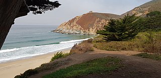
Gray Whale Cove State Beach is a California State Park between Pacifica, California, and Montara, California, by Highway 1 and approximately 18 miles south of San Francisco. It features a sheltered cove surrounded by abrupt cliffs, with trails connecting to nearby Montara Mountain and McNee Ranch State Park. It is located just south of Devil's Slide. The 3.1-acre (1.3 ha) park was established in 1966.
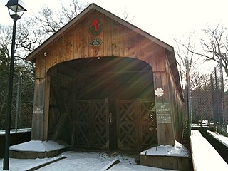
The Salmon River Trail is a 6.9-mile (11.1 km) Blue-Blazed hiking trail in Colchester, and East Hampton, Connecticut and is almost entirely in the Salmon River State Forest and Day Pond State Park. Almost all of the trail is in Colchester, the parking lot and part of the Comstock Covered Bridge over the Salmon River are in East Hampton.

The Menunkatuck Trail is an 11.0-mile (17.7 km) Blue-Blazed hiking trail in Guilford, Connecticut and, currently, is almost entirely on protected land owned by the Town of Guilford, the Guilford Conservation Land Trust, the Regional Water Authority (RWA) and on Cockaponset State Forest land.

The Quinebaug Trail is a 8.1-mile (13.0 km) Connecticut hiking trail and is one of the Blue-Blazed hiking trails maintained by the Connecticut Forest and Park Association.

The Pachaug Trail is a 28-mile (45 km) Connecticut hiking trail and is one of the Blue-Blazed hiking trails maintained by the Connecticut Forest and Park Association. It is a horseshoe shaped trail.

The Mattatuck Trail is an 42.2-mile (67.9 km) Blue-Blazed hiking trail that winds through Litchfield County and New Haven County in Western Connecticut.

The burgstall of Wolkenstein Castle is the site of a late medieval aristocratic castle in the village of Wolkenstein, in the borough of Ebermannstadt in the county of Forchheim in the German state of Bavaria. The burgstall is in private hands and may not be visited.


