Carroll County, Virginia

Last updated

Carroll County
CarrollCountyCourtFront.JPG
Carroll County Courthouse and Confederate Monument
Carroll Co Va Seal.png
Map of Virginia highlighting Carroll County.svg
Location within the U.S. state of Virginia
Virginia in United States.svg
Virginia's location within the U.S.
Coordinates: 36°44′N80°44′W / 36.73°N 80.73°W / 36.73; -80.73
CountryFlag of the United States.svg United States
StateFlag of Virginia.svg  Virginia
Founded1842
Named for Charles Carroll
Seat Hillsville
Largest townHillsville
Area
  Total478 sq mi (1,240 km2)
  Land475 sq mi (1,230 km2)
  Water3 sq mi (8 km2)  0.6%
Population
 (2020)
  Total29,155
  Density61/sq mi (24/km2)
Time zone UTC−5 (Eastern)
  Summer (DST) UTC−4 (EDT)
Congressional district 9th
Website www.carrollcountyva.org

Carroll County is a United States county located in the southwestern part of the Commonwealth of Virginia. Roughly one fifth of the county lies in the Virginia Piedmont region, while the rest is part of the Appalachian Mountains. The county seat and largest town is Hillsville. [1]

Contents

The county was established in 1842 from part of Grayson County, and was officially named in honor of Charles Carroll, a signer of the Declaration of Independence. The borders of Carroll County were later expanded by including land from Patrick County.

The total size of the county is 478 square miles (1,240 km2), and, as of the 2020 census, the population was 29,155. [2]

History

Charles Carroll of Carrollton, for whom the county was named Charles Carroll of Carrollton - Michael Laty.jpg
Charles Carroll of Carrollton, for whom the county was named

The first European settlers arrived in the region in the mid 18th century. These were primarily Scotch-Irish pioneers, who were used to high mountain altitudes. However, early settlement was slow, mostly due to the poor agricultural soil of the area. As a result, lead mining was one of the first economic activities in the region. [3]

As the area's population density increased, Carroll County was created in 1842 from part of Grayson County. The new county was officially named for Charles Carroll, a signer of the Declaration of Independence, from Maryland. [4] However, other accounts assert that John Carroll, a Virginia state legislator, had named the county in his own honor, but was blocked by a political rival who had it officially named for Charles Carroll instead. [3] [5]

Parts of Patrick County were added later to increase the size of Carroll County. The first piece was taken in 1845, and another part, which would later become the Fancy Gap District, was added in 1854. [3]

Geography

It is the only county in Virginia with Piedmont topography of roughly one fifth in the southeast part of the county and mountain topography of roughly four fifths elsewhere of the county. The Blue Ridge escarpment usually defines the county lines in both North Carolina and Virginia. The CDP community of Cana is in the Virginia Piedmont while the rest of the county is in the Appalachian Mountains.

According to the U.S. Census Bureau, the county has a total area of 478 square miles (1,240 km2), of which 475 square miles (1,230 km2) is land and 3 square miles (7.8 km2) (0.6%) is water. [6]

Adjacent counties / Independent city

Protected areas

National

Other

Major highways

Demographics

Historical population
CensusPop.Note
1850 5,909
1860 8,01235.6%
1870 9,14714.2%
1880 13,32345.7%
1890 15,49716.3%
1900 19,30324.6%
1910 21,1169.4%
1920 21,2830.8%
1930 22,1414.0%
1940 25,90417.0%
1950 26,6953.1%
1960 23,178−13.2%
1970 23,092−0.4%
1980 27,27018.1%
1990 26,594−2.5%
2000 29,24510.0%
2010 30,0422.7%
2020 29,155−3.0%
U.S. Decennial Census [7]
1790-1960 [8] 1900-1990 [9]
1990-2000 [10] 2010 [11] 2020 [12]

2020 census

Carroll County, Virginia – Racial and ethnic composition
Note: the US Census treats Hispanic/Latino as an ethnic category. This table excludes Latinos from the racial categories and assigns them to a separate category. Hispanics/Latinos may be of any race.
Race / Ethnicity (NH = Non-Hispanic)Pop 2010 [11] Pop 2020 [12] % 2010% 2020
White alone (NH)28,82027,04095.93%92.75%
Black or African American alone (NH)1771630.59%0.56%
Native American or Alaska Native alone (NH)49350.16%0.12%
Asian alone (NH)51800.17%0.27%
Pacific Islander alone (NH)530.02%0.01%
Some Other Race alone (NH)11420.04%0.14%
Mixed Race or Multi-Racial (NH)1537500.51%2.57%
Hispanic or Latino (any race)7761,0422.58%3.57%
Total30,04229,155100.00%100.00%

2000 Census

As of the census [13] of 2000, there were 29,245 people, 12,186 households, and 8,786 families residing in the county. The population density was 61 people per square mile (24 people/km2). There were 14,680 housing units at an average density of 31 units per square mile (12 units/km2). The racial makeup of the county was 97.97% White, 0.44% Black or African American, 0.14% Native American, 0.10% Asian, 0.82% from other races, and 0.53% from two or more races. 1.64% of the population were Hispanic or Latino of any race.

There were 12,186 households, out of which 27.80% had children under the age of 18 living with them, 59.70% were married couples living together, 8.60% had a female householder with no husband present, and 27.90% were non-families. 25.40% of all households were made up of individuals, and 12.20% had someone living alone who was 65 years of age or older. The average household size was 2.36 and the average family size was 2.80.

In the county, the population was spread out, with 21.10% under the age of 18, 7.20% from 18 to 24, 28.00% from 25 to 44, 26.70% from 45 to 64, and 17.00% who were 65 years of age or older. The median age was 41 years. For every 100 females there were 97.20 males. For every 100 females aged 18 and over, there were 94.10 males. The median income for a household in the county was $30,597, and the median income for a family was $36,755. Males had a median income of $25,907 versus $19,697 for females. The per capita income for the county was $16,475. About 8.70% of families and 12.50% of the population were below the poverty line, including 15.70% of those under age 18 and 14.10% of those age 65 or over.

Government and politics

Carroll County, like neighboring Floyd, is a historical anomaly in being a solidly Republican county in “Solid South” Virginia, due to desertions from the Confederate army during the Civil War. It was the only county in Virginia to vote for William Howard Taft during the 1912 election, and the only Democrat to carry the county in a presidential election since 1896 has been Franklin D. Roosevelt in 1932. [14] Since 1980 no Democrat has gained forty percent of the county's vote, and even with Virginian Tim Kaine on the ticket, Hillary Clinton gained less than twenty percent in the 2016 election. Democratic Senatorial candidate Mark Warner did however carry Carroll County in his landslide 2008 victory.

United States presidential election results for Carroll County, Virginia [15]
Year Republican Democratic Third party
No.%No.%No.%
2020 12,65980.88%2,84218.16%1500.96%
2016 10,66378.09%2,55918.74%4333.17%
2012 8,73667.63%3,68528.53%4973.85%
2008 8,18765.08%4,10932.67%2832.25%
2004 8,17367.39%3,88832.06%670.55%
2000 7,14264.92%3,63833.07%2212.01%
1996 5,08851.04%3,61136.22%1,27012.74%
1992 5,66451.89%3,79034.72%1,46113.39%
1988 6,37766.17%3,19033.10%700.73%
1984 7,05670.26%2,91429.02%720.72%
1980 5,90561.29%3,43735.68%2923.03%
1976 4,82053.75%4,01044.71%1381.54%
1972 5,24775.08%1,58322.65%1592.28%
1968 4,90964.16%1,77323.17%96912.67%
1964 3,61758.85%2,51740.95%120.20%
1960 3,70566.29%1,87333.51%110.20%
1956 4,06069.66%1,73929.84%290.50%
1952 3,77468.68%1,71131.14%100.18%
1948 2,45665.72%1,19632.00%852.27%
1944 2,35263.07%1,37536.87%20.05%
1940 1,83554.19%1,54645.66%50.15%
1936 3,24560.45%2,12239.53%10.02%
1932 1,46148.28%1,53750.79%280.93%
1928 2,45968.76%1,11731.24%00.00%
1924 1,74357.79%1,25741.68%160.53%
1920 2,52066.47%1,26533.37%60.16%
1916 1,42462.40%85837.60%00.00%
1912 87443.96%76538.48%34917.56%

Education

Public high schools

Carroll County High School, in Hillsville, serves the county. Home of the Cavaliers, CCHS is a 9-12 comprehensive high school. The school was created by the consolidation of Woodlawn High School (Woodlawn, Virginia) and Hillsville High School (Hillsville, Virginia).

Communities

Town

Census-designated places

Other unincorporated communities

Notable people

See also

Related Research Articles

<span class="mw-page-title-main">Calhoun County, Alabama</span> County in Alabama, United States

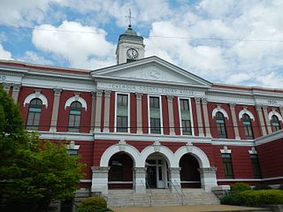
Calhoun County is a county in the east central part of the U.S. state of Alabama. As of the 2020 census, the population was 116,441. Its county seat is Anniston. It is named in honor of John C. Calhoun, a US Senator from South Carolina.

<span class="mw-page-title-main">Cherokee County, Alabama</span> County in Alabama, United States

Cherokee County, Alabama is a county located in the northeastern part of the U.S. state of Alabama. As of the 2020 census, the population was 24,971. Its county seat is Centre. The county is named for the Cherokee tribe.

<span class="mw-page-title-main">Cleburne County, Alabama</span> County in Alabama, United States

Cleburne County is a county located in the east central portion of the U.S. state of Alabama. As of the 2020 census, the population was 15,056. Its county seat is Heflin. Its name is in honor of Patrick R. Cleburne of Arkansas who rose to the rank of major general in the Confederate States Army. The eastern side of the county borders the state of Georgia.

<span class="mw-page-title-main">Randolph County, Alabama</span> County in Alabama, United States

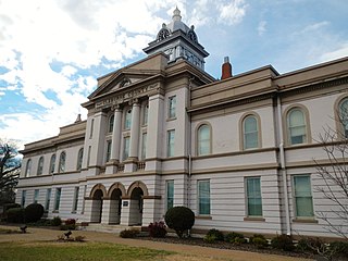
Randolph County is a county on the central eastern border of the U.S. state of Alabama. As of the 2020 census, the population was 21,967. Its county seat is Wedowee. Its name is in honor of John Randolph, a member of the United States Senate from Virginia. Randolph County was a prohibition or dry county until 2012, when the citizens of Randolph County voted to repeal prohibition.

<span class="mw-page-title-main">Washington County, Virginia</span> County in Virginia, United States

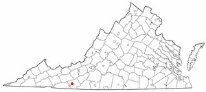
Washington County is a county located in the Commonwealth of Virginia. As of the 2020 census, the population was 53,935. Its county seat is Abingdon.

<span class="mw-page-title-main">Smyth County, Virginia</span> County in Virginia, United States

Smyth County is a county located in the U.S. state of Virginia. As of the 2020 census, the population was 29,800. Its county seat is Marion.

<span class="mw-page-title-main">Grayson County, Virginia</span> County in Virginia, United States

Grayson County is a county located in the southwestern part of the Commonwealth of Virginia. As of the 2020 census, the population was 15,333. Its county seat is Independence. Mount Rogers, the state's highest peak at 5,729 feet (1,746 m), is in Grayson County.

<span class="mw-page-title-main">Galax, Virginia</span> Independent city in Virginia, United States

Galax is an independent city in the southwestern part of the Commonwealth of Virginia. As of the 2020 census, the population was 6,720.

<span class="mw-page-title-main">Appomattox County, Virginia</span> County in Virginia, United States

Appomattox County is a United States county located in the Piedmont region and near the center of the Commonwealth of Virginia. The county is part of the Lynchburg, VA Metropolitan Statistical Area, and its county seat is the town of Appomattox.

<span class="mw-page-title-main">Fannin County, Texas</span> County in Texas, United States

Fannin County is a county in the far northeast of the U.S. state of Texas, on the border with Oklahoma. As of the 2020 census, its population was 35,662. The county seat is Bonham.

<span class="mw-page-title-main">Laurel, Florida</span> Census-designated place in Florida, United States

Laurel is a census-designated place (CDP) in Sarasota County, Florida, United States. The population was 12,186 as of 2020 census.

<span class="mw-page-title-main">Woodlawn, Prince George's County, Maryland</span> Census-designated place in Maryland

Woodlawn is an unincorporated area and census-designated place (CDP) in Prince George's County, Maryland, United States. As of the 2020 census it had a population of 7,541.

<span class="mw-page-title-main">Hillsville, Virginia</span> Town in Virginia, United States

Hillsville is a town in Carroll County, Virginia, United States. The population was 2,897 at the 2020 census. It is the county seat of Carroll County.

<span class="mw-page-title-main">Woodlawn, Carroll County, Virginia</span> CDP in Virginia, United States

Woodlawn is a census-designated place (CDP) in Carroll County, Virginia, United States. The population was 2,045 at the 2020 census.

<span class="mw-page-title-main">Great Falls, Virginia</span> Census-designated place in Virginia, United States

Great Falls is a census-designated place in Fairfax County, Virginia, United States. The population at the 2020 census was 15,953.

<span class="mw-page-title-main">West Milford, West Virginia</span> Town in West Virginia, United States

West Milford is a town in Harrison County, West Virginia, United States. The population was 452 at the 2020 census.

<span class="mw-page-title-main">Glasgow, West Virginia</span> Town in West Virginia, United States

Glasgow is a town in Kanawha County, West Virginia, United States, situated along the Kanawha River. The population was 708 at the 2020 census. Glasgow was incorporated on June 20, 1920. Folk etymology derives its name from a combination of the word "glass" with the word "company" for a glass factory that was built there many years ago, but the presence of many Scottish immigrants to this part of Appalachia, particularly from the Strathclyde region, indicates that the town was most likely named after the Scottish city of Glasgow in Strathclyde. Other Virginia and West Virginia locations named for places in Strathclyde include Dumbarton, Argyle, Loudoun County, Hamilton in Loudoun County, Lanark and Renfrew.

<span class="mw-page-title-main">Peterstown, West Virginia</span> Town in West Virginia, United States

Peterstown is a town in Monroe County, West Virginia, United States. The population was 456 at the 2020 census.

<span class="mw-page-title-main">West Liberty, West Virginia</span> Town in West Virginia, United States

West Liberty is a town in Ohio County, West Virginia, United States. The population was 1,557 at the 2020 census. It is part of the Wheeling metropolitan area.

<span class="mw-page-title-main">Newburg, West Virginia</span> Town in West Virginia, United States

Newburg is a town in western Preston County, West Virginia, United States. The population was 275 at the 2020 census. It is part of the Morgantown metropolitan area.

References

  1. "Find a County". National Association of Counties. Archived from the original on May 31, 2011. Retrieved June 7, 2011.
  2. "Carroll County, Virginia". United States Census Bureau . Retrieved January 30, 2022.
  3. 1 2 3 Willis, Ninevah. "A Brief History Of Carroll County, Virginia". The Journal of Mountain Life (October 1984). Retrieved March 20, 2015.
  4. Gannett, Henry (1905). The Origin of Certain Place Names in the United States. Govt. Print. Off. p. 70.
  5. Tennis, Joe (2004). Southwest Virginia Crossroads: An Almanac of Place Names and Places to See. Johnson City, Tenn.: Overmountain Press. p. 91. ISBN   978-1570722561.
  6. "US Gazetteer files: 2010, 2000, and 1990". United States Census Bureau. February 12, 2011. Retrieved April 23, 2011.
  7. "Census of Population and Housing from 1790-2000". US Census Bureau . Retrieved January 24, 2022.
  8. "Historical Census Browser". University of Virginia Library. Retrieved January 1, 2014.
  9. "Population of Counties by Decennial Census: 1900 to 1990". United States Census Bureau. Retrieved January 1, 2014.
  10. "Census 2000 PHC-T-4. Ranking Tables for Counties: 1990 and 2000" (PDF). United States Census Bureau. Retrieved January 1, 2014.
  11. 1 2 "P2 HHispanic or Latino, and Not Hispanic or Latino by Race – 2010: DEC Redistricting Data (PL 94-171) - Carroll County, Virginia". United States Census Bureau .
  12. 1 2 "P2 Hispanic or Latino, and Not Hispanic or Latino by Race – 2020: DEC Redistricting Data (PL 94-171) - Carroll County, Virginia". United States Census Bureau .
  13. "U.S. Census website". United States Census Bureau . Retrieved May 14, 2011.
  14. Menendez, Albert J.; The Geography of Presidential Elections in the United States, 1868-2004, pp. 323, 326, 329 ISBN   0786422173
  15. David Leip. "Dave Leip's Atlas of U.S. Presidential Elections". Uselectionatlas.org. Retrieved December 9, 2020.

36°44′N80°44′W / 36.73°N 80.73°W / 36.73; -80.73