Essex County, Virginia

Last updated

Essex County
Essex County VA courthouse2.JPG
Essex County Courthouse in Tappahannock
Flag of Essex County, Virginia.png
Essexcountyseal.png
Map of Virginia highlighting Essex County.svg
Location within the U.S. state of Virginia
Virginia in United States.svg
Virginia's location within the U.S.
Coordinates: 37°56′N76°57′W / 37.94°N 76.95°W / 37.94; -76.95
CountryFlag of the United States.svg United States
StateFlag of Virginia.svg  Virginia
Founded1692
Seat Tappahannock
Largest townTappahannock
Area
  Total286 sq mi (740 km2)
  Land257 sq mi (670 km2)
  Water29 sq mi (80 km2)  10.1%
Population
 (2020)
  Total10,599
  Density37/sq mi (14/km2)
Time zone UTC−5 (Eastern)
  Summer (DST) UTC−4 (EDT)
Congressional district 1st
Website www.essex-virginia.org

Essex County is a county located in the Middle Peninsula in the U.S. state of Virginia; the peninsula is bordered by the Rappahannock River on the north and King and Queen County on the south. As of the 2020 census, the population was 10,599. [1] Its county seat is Tappahannock. [2]

Contents

History

Essex County was established in 1692 from the old Rappahannock County, Virginia (not to be confused with the present-day Rappahannock County, Virginia). The county is named for either the shire or county in England, or for the Earl of Essex.

Geography

According to the U.S. Census Bureau, the county has a total area of 286 square miles (740 km2), of which 257 square miles (670 km2) is land and 29 square miles (75 km2) (10.1%) is water. [3] Its main town, Tappahanock, is focused at the Rappahanock River.

Adjacent counties

Major highways

National protected area

Demographics

Historical population
CensusPop.Note
1790 9,122
1800 9,5084.2%
1810 9,376−1.4%
1820 9,9095.7%
1830 10,5216.2%
1840 11,3097.5%
1850 10,206−9.8%
1860 10,4692.6%
1870 9,927−5.2%
1880 11,03211.1%
1890 10,047−8.9%
1900 9,701−3.4%
1910 9,105−6.1%
1920 8,542−6.2%
1930 6,976−18.3%
1940 7,0060.4%
1950 6,530−6.8%
1960 6,6902.5%
1970 7,0996.1%
1980 8,86424.9%
1990 8,689−2.0%
2000 9,98915.0%
2010 11,15111.6%
2020 10,599−5.0%
U.S. Decennial Census [4]
1790-1960 [5] 1900-1990 [6]
1990-2000 [7] 2010 [8] 2020 [9]

2020 census

Essex County, Virginia – Racial and ethnic composition
Note: the US Census treats Hispanic/Latino as an ethnic category. This table excludes Latinos from the racial categories and assigns them to a separate category. Hispanics/Latinos may be of any race.
Race / Ethnicity (NH = Non-Hispanic)Pop 2010 [8] Pop 2020 [9] % 2010% 2020
White alone (NH)6,2395,87155.95%55.39%
Black or African American alone (NH)4,2243,74337.88%35.31%
Native American or Alaska Native alone (NH)46610.41%0.58%
Asian alone (NH)86620.77%0.58%
Pacific Islander alone (NH)230.02%0.03%
Some Other Race alone (NH)13400.12%0.38%
Mixed Race or Multi-Racial (NH)1924501.72%4.25%
Hispanic or Latino (any race)3493693.13%3.48%
Total11,15110,599100.00%100.00%

2000 Census

As of the census [10] of 2000, there were 9,989 people, 3,995 households, and 2,740 families residing in the county. The population density was 39 people per square mile (15 people/km2). There were 4,926 housing units at an average density of 19 units per square mile (7.3 units/km2). The racial makeup of the county was 57.96% White, 39.04% Black or African American, 0.55% Native American, 0.81% Asian, 0.03% Pacific Islander, 0.32% from other races, and 1.28% from two or more races. 0.72% of the population were Hispanic or Latino of any race.

There were 3,995 households, out of which 28.00% had children under the age of 18 living with them, 50.70% were married couples living together, 14.00% had a female householder with no husband present, and 31.40% were non-families. 26.10% of all households were made up of individuals, and 11.30% had someone living alone who was 65 years of age or older. The average household size was 2.46 and the average family size was 2.95.

In the county, the population was spread out, with 22.90% under the age of 18, 7.00% from 18 to 24, 27.00% from 25 to 44, 25.70% from 45 to 64, and 17.30% who were 65 years of age or older. The median age was 40 years. For every 100 females there were 89.90 males. For every 100 females age 18 and over, there were 88.20 males.

The median income for a household in the county was $37,395, and the median income for a family was $43,588. Males had a median income of $29,736 versus $22,253 for females. The per capita income for the county was $17,994. About 7.70% of families and 11.20% of the population were below the poverty line, including 16.80% of those under age 18 and 11.80% of those age 65 or over.

Government

Board of supervisors

Constitutional officers

Essex is represented by Republican Ryan T. McDougle in the Virginia Senate, Republican M. Keith Hodges in the Virginia House of Delegates, and Republican Robert J. "Rob" Wittman in the U.S. House of Representatives.

United States presidential election results for Essex County, Virginia [11]
Year Republican Democratic Third party
No.%No.%No.%
2020 3,07549.77%3,03849.17%651.05%
2016 2,65749.46%2,54247.32%1733.22%
2012 2,60245.85%3,01653.15%571.00%
2008 2,37944.35%2,93454.70%510.95%
2004 2,30453.04%2,00746.20%330.76%
2000 1,99552.08%1,75045.68%862.24%
1996 1,62746.05%1,66847.21%2386.74%
1992 1,89748.59%1,58340.55%42410.86%
1988 2,03860.56%1,29438.45%330.98%
1984 2,12061.63%1,30037.79%200.58%
1980 1,58152.93%1,28042.85%1264.22%
1976 1,38050.55%1,30647.84%441.61%
1972 1,48262.58%80834.12%783.29%
1968 79136.55%89741.45%47622.00%
1964 78950.90%76049.03%10.06%
1960 60654.25%50945.57%20.18%
1956 59755.48%32830.48%15114.03%
1952 61052.45%54546.86%80.69%
1948 22133.95%32950.54%10115.51%
1944 17925.98%50873.73%20.29%
1940 14520.92%54778.93%10.14%
1936 11617.98%52781.71%20.31%
1932 10119.27%42080.15%30.57%
1928 19537.79%32162.21%00.00%
1924 6015.63%31582.03%92.34%
1920 10124.05%31975.95%00.00%
1916 7720.32%30279.68%00.00%
1912 7219.94%27877.01%113.05%

Education

Essex County Public Schools (ECPS) is the public schools system for Essex County, Virginia, United States. [12] The following schools make up the Essex County Public Schools system:

Tappahannock Elementary School (Grades PK - 4th) [13]
Essex Intermediate School (Grades 5th - 8th) [14]
Essex High School (Grades 9th - 12th) [15]

Other schools located in Essex County include:

St Margaret's School (Grades 8th - 12th, girls only) [16]
Tappahannock Junior Academy (Grades K - 10th) [17]
Aylett Country Day School (Grades PK - 8th) [18]

Communities

Town

Unincorporated communities

Notable people

See also

Related Research Articles

<span class="mw-page-title-main">Westmoreland County, Virginia</span> County in Virginia, United States

Westmoreland County is a county located in the Northern Neck of the Commonwealth of Virginia. As of the 2020 census, the population sits at 18,477. Its county seat is Montross.

<span class="mw-page-title-main">Washington County, Virginia</span> County in Virginia, United States

Washington County is a county located in the Commonwealth of Virginia. As of the 2020 census, the population was 53,935. Its county seat is Abingdon.

<span class="mw-page-title-main">Warren County, Virginia</span> County in Virginia, United States

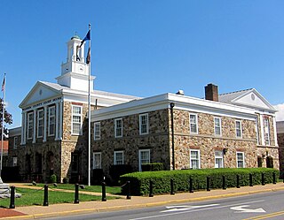
Warren County is a U.S. county located in the Commonwealth of Virginia. The 2020 census places Warren County within the Washington-Arlington-Alexandria, DC-VA-MD-WV Metropolitan Statistical Area with a population of 40,727. The county was established in 1836. The county seat is Front Royal.

<span class="mw-page-title-main">Richmond County, Virginia</span> County in Virginia, United States

Richmond County is a county located on the Northern Neck in the U.S. state of Virginia. As of the 2020 census, the population sits at 8,923. Its county seat is Warsaw. The rural county should not be confused with the large city and state capital Richmond, Virginia. It was formed in 1692 when the first Rappahannock County was divided to form Richmond County and Essex County.

<span class="mw-page-title-main">Page County, Virginia</span> County in Virginia, United States

Page County is located in the Commonwealth of Virginia. As of the 2020 census, the population was 23,709. Its county seat is Luray. Page County was formed in 1831 from Shenandoah and Rockingham counties and was named for John Page, Governor of Virginia from 1802 to 1805.

<span class="mw-page-title-main">New Kent County, Virginia</span> County in Virginia, United States

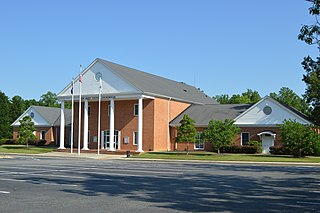
New Kent County is a county in the south eastern part the Commonwealth of Virginia. As of the 2020 United States Census, its population was 22,945. Its county seat is New Kent.

<span class="mw-page-title-main">Middlesex County, Virginia</span> County in Virginia, United States

Middlesex County is a county located on the Middle Peninsula in the U.S. state of Virginia. As of the 2020 census, the population was 10,625. Its county seat is Saluda.

<span class="mw-page-title-main">Madison County, Virginia</span> County in Virginia, United States

Madison County is a county located in the Commonwealth of Virginia. As of the 2020 census, the population was 13,837. Its county seat is Madison.

<span class="mw-page-title-main">Lancaster County, Virginia</span> County in Virginia, United States

Lancaster County is a county located on the Northern Neck in the Commonwealth of Virginia. As of the 2020 census, the population sits at 10,919. Its county seat is Lancaster.

<span class="mw-page-title-main">King George County, Virginia</span> County in Virginia, United States

King George County is a county located in the Commonwealth of Virginia. As of the 2020 census, the population sits at 26,723. Its county seat is the town of King George.

<span class="mw-page-title-main">Fauquier County, Virginia</span> County in Virginia, United States

Fauquier County is a county in the Commonwealth of Virginia. As of the 2020 census, the population was 72,972. The county seat is Warrenton.

<span class="mw-page-title-main">Culpeper County, Virginia</span> County in Virginia, United States

Culpeper County is a county located along the borderlands of the northern and central region of the Commonwealth of Virginia. As of the 2020 United States Census, the population was 52,552. Its county seat and only incorporated community is Culpeper.

<span class="mw-page-title-main">Covington, Virginia</span> Independent city in Virginia, United States

Covington is an independent city in the Commonwealth of Virginia. As of the 2020 census, the population was 5,737, making it the second-least populous city in Virginia. It is surrounded by Alleghany County, of which it is also the county seat. Located at the confluence of Jackson River and Dunlap Creek, Covington is one of three cities in the Roanoke Regional Partnership. The Bureau of Economic Analysis combines the city of Covington with Alleghany county for statistical purposes.

<span class="mw-page-title-main">Port Royal, Virginia</span> Town in Virginia, United States

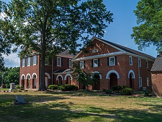
Port Royal is an incorporated town in Caroline County, Virginia, United States. The population was 126 at the 2010 census.

<span class="mw-page-title-main">Tappahannock, Virginia</span> Town in Virginia, United States

Tappahannock is the oldest town in Essex County, Virginia, United States. The population was 2,375 at the 2010 census, up from 2,068 at the 2000 census. Located on the Rappahannock River, Tappahannock is the county seat of Essex County. Its name comes from an Algonquian language word lappihanne, meaning "Town on the rise and fall of water" or "where the tide ebbs and flows." The Rappahannock is a tidal estuary from above this point and downriver to its mouth on Chesapeake Bay.

<span class="mw-page-title-main">White Stone, Virginia</span> Town in Virginia, United States

White Stone is a town in Lancaster County, Virginia, United States. The population was 380 at the 2020 census. White Stone is one of many small towns located in Virginia's Northern Neck region.

<span class="mw-page-title-main">Warsaw, Virginia</span> Town in Virginia, United States

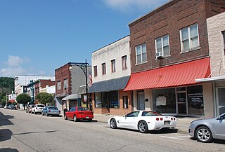
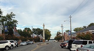
Warsaw is an incorporated town in and the county seat of Richmond County, Virginia, United States. The population was 1,637 at the 2020 census and is estimated to be 2,281 as of 2022.

<span class="mw-page-title-main">Westover, West Virginia</span> City in West Virginia

Westover is a city in Monongalia County, West Virginia, United States, along the Monongahela River. The population was 3,995 at the 2020 census. It is part of the Morgantown metropolitan area.

<span class="mw-page-title-main">Kilmarnock, Virginia</span> Town in Virginia, United States

Kilmarnock is a town in Lancaster and Northumberland counties in the U.S. Commonwealth of Virginia. The population was 1,487 at the 2010 census. It is located near the mouth of the Rappahannock River and is located within the Northern Neck George Washington Birthplace American Viticultural Area winemaking appellation. There is a small hospital in the town. Lancaster Middle School, grades 4–8, is also located in town. Approximately 500 students attend the school.

<span class="mw-page-title-main">King William County, Virginia</span> County in Virginia, United States

King William County is a county located in the U.S. state of Virginia. As of the 2020 census, the population was 17,810. Its county seat is King William.

References

  1. "Essex County, Virginia". United States Census Bureau . Retrieved January 30, 2022.
  2. "Find a County". National Association of Counties. Archived from the original on May 31, 2011. Retrieved June 7, 2011.
  3. "US Gazetteer files: 2010, 2000, and 1990". United States Census Bureau. February 12, 2011. Retrieved April 23, 2011.
  4. "Census of Population and Housing from 1790-2000". US Census Bureau . Retrieved January 24, 2022.
  5. "Historical Census Browser". University of Virginia Library. Retrieved January 2, 2014.
  6. "Population of Counties by Decennial Census: 1900 to 1990". United States Census Bureau. Retrieved January 2, 2014.
  7. "Census 2000 PHC-T-4. Ranking Tables for Counties: 1990 and 2000" (PDF). United States Census Bureau. Archived (PDF) from the original on October 9, 2022. Retrieved January 2, 2014.
  8. 1 2 "P2 Hispanic or Latino, and Not Hispanic or Latino by Race – 2010: DEC Redistricting Data (PL 94-171) - Essex County, Virginia". United States Census Bureau .
  9. 1 2 "P2 Hispanic or Latino, and Not Hispanic or Latino by Race – 2020: DEC Redistricting Data (PL 94-171) - Essex County, Virginia". United States Census Bureau .
  10. "U.S. Census website". United States Census Bureau . Retrieved May 14, 2011.
  11. David Leip. "Dave Leip's Atlas of U.S. Presidential Elections". Uselectionatlas.org. Retrieved December 9, 2020.
  12. http://www.essex.k12.va.us Essex
  13. "Home - Tappahannock Elementary School". essextes.sharpschool.net.
  14. "Home - Essex Intermediate School". eis.essex.k12.va.us.
  15. "Home - Essex High School". essexehs.sharpschool.net.
  16. "St. Margaret's - Girls Boarding School Near Fredericksburg & Richmond, VA". www.sms.org.
  17. "Home : Tappahannock Junior Academy Tappahannock VA". tappahannock22.adventistschoolconnect.org.
  18. "Aylett Country Day School~Home of the Patriots". www.acdspatriots.net.

37°56′N76°57′W / 37.94°N 76.95°W / 37.94; -76.95