Sussex County, Virginia

Last updated

Sussex County
Sussex County Courthouse (Built 1828), Sussex, Virginia.jpg
Map of Virginia highlighting Sussex County.svg
Location within the U.S. state of Virginia
Virginia in United States.svg
Virginia's location within the U.S.
Coordinates: 36°56′N77°16′W / 36.93°N 77.26°W / 36.93; -77.26
CountryFlag of the United States.svg United States
StateFlag of Virginia.svg  Virginia
Founded1754
Named for Sussex, England
Seat Sussex
Largest town Waverly
Area
  Total493 sq mi (1,280 km2)
  Land490 sq mi (1,300 km2)
  Water2.6 sq mi (7 km2)  0.5%
Population
 (2020)
  Total10,829
  Density22/sq mi (8.5/km2)
Time zone UTC−5 (Eastern)
  Summer (DST) UTC−4 (EDT)
Congressional district 4th
Website www.sussexcountyva.gov

Sussex County is a rural county located in the southeast of the Commonwealth of Virginia. As of the 2020 census, the population was 10,829. [1] Its county seat is Sussex. [2] It was formed in 1754 from Surry County. The county is named after the county of Sussex, England. [3]

Contents

Sussex County is included in the Greater Richmond Region.

History

Native Americans may have settled near Cactus Hill along the Nottoway River as long as 10,000 years ago. This area later was organized by English colonists as Sussex County. [4] The historic Nottoway people, although they spoke an Iroquoian language, were loosely part of the Powhatan Confederacy. It was comprised mainly of Algonquian-speaking peoples from the coastal zone.

When colonists arrived from England in 1607, some traveled along the Nottoway River. But when they established the first counties in the colony, James City County included both sides of the James River to the North Carolina line. The south side of the James River later was organized as Surry County in 1652. Virginia's General Assembly formed Sussex County in 1754 from the southwestern end of Surry County.

Sussex County has maintained a predominantly agricultural economy, once based in tobacco and cotton commodity crops, with work primarily done by enslaved African Americans. It has preserved some of its historic heritage for centuries. Important sites include the Nottoway Archeological Site, Sussex County Courthouse Historic District and the Waverly Downtown Historic District, and six historic homes, all listed on the National Register of Historic Places.

The largest forest fire in Virginia's recorded history occurred on April 5, 1943, destroying more than 12,000 acres in six hours. Fire were usually fought by recruiting workmen from Gray Lumber Company, but the mill was closed and most were attending the funeral of Ella Darden Gray, matriarch of one of the county's leading families. Her son Senator Garland Gray helped bring attention to the state's need for more protection for valuable forests. [5]

About a decade later, Senator Gray became a leader in the Massive Resistance of whites against desegregating Virginia's public schools. [6]

Geography

According to the U.S. Census Bureau, the county has a total area of 493 square miles (1,280 km2), of which 490 square miles (1,300 km2) is land and 2.6 square miles (6.7 km2) (0.5%) is water. [7]

Adjacent counties

Major highways

Demographics

Historical population
CensusPop.Note
1790 10,549
1800 11,0624.9%
1810 11,3622.7%
1820 11,8844.6%
1830 12,7207.0%
1840 11,229−11.7%
1850 9,820−12.5%
1860 10,1753.6%
1870 7,885−22.5%
1880 10,06227.6%
1890 11,10010.3%
1900 12,0828.8%
1910 13,66413.1%
1920 12,834−6.1%
1930 12,100−5.7%
1940 12,4853.2%
1950 12,7852.4%
1960 12,411−2.9%
1970 11,464−7.6%
1980 10,874−5.1%
1990 10,248−5.8%
2000 12,50422.0%
2010 12,087−3.3%
2020 10,829−10.4%
2021 (est.)10,763 [8] −0.6%
U.S. Decennial Census [9]
1790-1960 [10] 1900-1990 [11]
1990-2000 [12] 2010 [13] 2020 [14]

2020 census

Sussex County, Virginia – Racial and ethnic composition
Note: the US Census treats Hispanic/Latino as an ethnic category. This table excludes Latinos from the racial categories and assigns them to a separate category. Hispanics/Latinos may be of any race.
Race / Ethnicity (NH = Non-Hispanic)Pop 2000 [15] Pop 2010 [13] Pop 2020 [14] % 2000% 2010% 2020
White alone (NH)4,5374,6634,38136.28%38.58%40.46%
Black or African American alone (NH)7,7506,9965,76661.98%57.88%53.25%
Native American or Alaska Native alone (NH)1619140.13%0.16%0.13%
Asian alone (NH)1546110.12%0.38%0.10%
Pacific Islander alone (NH)1070.01%0.00%0.06%
Some Other Race alone (NH)59250.04%0.07%0.23%
Mixed Race or Multi-Racial (NH)78863190.62%0.71%2.95%
Hispanic or Latino (any race)1022683060.82%2.22%2.83%
Total12,50412,08710,829100.00%100.00%100.00%

2010 Census

As of the 2010 United States Census, there were 12,087 people living in the county, of which 58.1% were Black or African American, 39.3% White, 0.4% Asian, 0.2% Native American, 1.3% of some other race and 0.8% of two or more races. 2.2% were Hispanic or Latino (of any race).

As of the census [16] of 2000, there were 12,504 people, 4,126 households, and 2,809 families living in the county. The population density was 26 people per square mile (10 people/km2). There were 4,653 housing units at an average density of 10 units per square mile (3.9 units/km2). The racial makeup of the county was 62.13% Black or African American, 36.39% White, 0.13% Native American, 0.12% Asian, 0.02% Pacific Islander, 0.54% from other races, and 0.67% from two or more races. 0.82% of the population were Hispanic or Latino of any race.

There were 4,126 households, out of which 28.50% had children under the age of 18 living with them, 45.00% were married couples living together, 18.90% had a female householder with no husband present, and 31.90% were non-families. 28.20% of all households were made up of individuals, and 12.40% had someone living alone who was 65 years of age or older. The average household size was 2.41 and the average family size was 2.94.

In the county, the population was spread out, with 19.60% under the age of 18, 9.00% from 18 to 24, 34.40% from 25 to 44, 23.60% from 45 to 64, and 13.40% who were 65 years of age or older. The median age was 38 years. For every 100 females there were 135.10 males. For every 100 females age 18 and over, there were 142.30 males.

The median income for a household in the county was $31,007, and the median income for a family was $36,739. Males had a median income of $29,307 versus $22,001 for females. The per capita income for the county was $14,670. About 12.80% of families and 16.10% of the population were below the poverty line, including 24.30% of those under age 18 and 19.20% of those age 65 or over.

Two prisons were built in Sussex County in the 1990s. Including the prisons, Sussex County was the fastest growing county in the United States. Excluding the prisons, the county population declined. [17]

Education

Sussex County Public Schools operates public schools.

Blackwater Regional Library is the regional library system that provides services to the citizens of Sussex.

High school

Middle school

Elementary schools

Charter/tech

Private schools

Government and infrastructure

The Virginia Department of Corrections operates the Sussex I State Prison and the Sussex II State Prison in unincorporated Sussex County, near Waverly. [18] [19] [20] The Sussex I center housed the male death row. On August 3, 1998, the male death row moved to Sussex I from the Mecklenburg Correctional Center. [21]

Politics

United States presidential election results for Sussex County, Virginia [22]
Year Republican Democratic Third party
No.%No.%No.%
2020 2,21943.61%2,82755.56%420.83%
2016 2,05540.74%2,87957.08%1102.18%
2012 2,02137.15%3,35861.73%611.12%
2008 2,02637.78%3,30161.55%360.67%
2004 1,89043.50%2,42055.70%350.81%
2000 1,74544.67%2,00651.36%1553.97%
1996 1,37836.34%2,08955.09%3258.57%
1992 1,52735.90%2,19351.56%53312.53%
1988 1,82246.77%1,95850.26%1162.98%
1984 2,18346.14%2,40850.90%1402.96%
1980 1,66438.94%2,44757.27%1623.79%
1976 1,36033.22%2,49760.99%2375.79%
1972 2,12054.99%1,64542.67%902.33%
1968 1,10529.12%1,54140.62%1,14830.26%
1964 1,53755.39%1,23444.47%40.14%
1960 71335.78%1,25362.87%271.35%
1956 78539.31%85142.61%36118.08%
1952 88847.97%95651.65%70.38%
1948 24420.00%61450.33%36229.67%
1944 20120.51%77378.88%60.61%
1940 16418.16%73781.62%20.22%
1936 12612.52%88087.48%00.00%
1932 12214.79%68883.39%151.82%
1928 38541.31%54758.69%00.00%
1924 13217.67%60781.26%81.07%
1920 16623.15%54876.43%30.42%
1916 9616.35%48682.79%50.85%
1912 5910.52%43577.54%6711.94%

Communities

Towns

Census-designated place

Unincorporated communities

See also

Related Research Articles

<span class="mw-page-title-main">Bradford County, Florida</span> County in Florida, United States

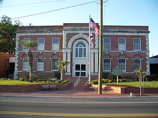
Bradford County is a county in the U.S. state of Florida. As of the 2020 census, the population was 28,303. Its county seat and largest city is Starke.

<span class="mw-page-title-main">Union County, Florida</span> County in Florida, United States

Union County is a county located in the north central portion of the U.S. state of Florida, the smallest in the state by area. As of the 2020 census, the population was 16,147. The county seat is Lake Butler. With a personal per capita income of $18,396, it is the poorest county in the United States.

<span class="mw-page-title-main">Escambia County, Alabama</span> County in Alabama, United States

Escambia County is a county located in the south central portion of the U.S. state of Alabama. As of the 2020 census, the population was 36,757. Its county seat is Brewton.

<span class="mw-page-title-main">Southampton County, Virginia</span> County in Virginia, United States

Southampton County is a county located on the southern border of the Commonwealth of Virginia. North Carolina is to the south. As of the 2020 census, the population was 17,996. Its county seat is Courtland.

<span class="mw-page-title-main">Prince George County, Virginia</span> County in Virginia, United States

Prince George County is a county located in the Commonwealth of Virginia. As of the 2020 census, the population was 43,010. Its county seat is Prince George.

<span class="mw-page-title-main">Nottoway County, Virginia</span> County in Virginia, United States

Nottoway County is a county located in the Commonwealth of Virginia. As of the 2020 census, the population was 15,642. Its county seat is Nottoway. It is situated south of the James River, thus making it a part of the Southside Virginia Region.

<span class="mw-page-title-main">Lunenburg County, Virginia</span> County in Virginia, United States

Lunenburg County is a county located in the Commonwealth of Virginia. As of the 2020 census, the population was 11,936. Its county seat is Lunenburg.

<span class="mw-page-title-main">Greensville County, Virginia</span> County in Virginia, United States

Greensville County is a county located in the Commonwealth of Virginia. As of the 2020 census, the population was 11,391. Its county seat is Emporia.

<span class="mw-page-title-main">Grayson County, Virginia</span> County in Virginia, United States

Grayson County is a county located in the southwestern part of the Commonwealth of Virginia. As of the 2020 census, the population was 15,333. Its county seat is Independence. Mount Rogers, the state's highest peak at 5,729 feet (1,746 m), is in Grayson County.

<span class="mw-page-title-main">Emporia, Virginia</span> Independent city in Virginia, United States

Emporia is an independent city in the Commonwealth of Virginia, surrounded by Greensville County, United States. Emporia and a predecessor town have been the county seat of Greensville County since 1791. As of the 2020 census, the population was 5,766, making it the third-least populous city in Virginia. The Bureau of Economic Analysis combines the city of Emporia with surrounding Greensville County for statistical purposes.

<span class="mw-page-title-main">Dinwiddie County, Virginia</span> County in Virginia, United States

Dinwiddie County is a county located in the Commonwealth of Virginia. As of the 2020 census, the population was 27,947. Its county seat is Dinwiddie.

<span class="mw-page-title-main">Brunswick County, Virginia</span> County in Virginia, United States

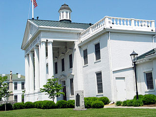
Brunswick County is a United States county located on the southern border of the Commonwealth of Virginia. This rural county is known as one of the claimants to be the namesake of Brunswick stew. Brunswick County was created in 1720 from parts of Prince George, Surry and Isle of Wight counties. The county was named for the former Duchy of Brunswick-Lunenburg, the region from which the British monarchs of the House of Hanover originated. As of the 2020 census, the county population was 15,849. The Brunswick county seat is Lawrenceville.

<span class="mw-page-title-main">Amelia County, Virginia</span> County in Virginia, United States

Amelia County is a county located just southwest of Richmond in the Commonwealth of Virginia, United States. The county is located in Central Virginia and is included in the Greater Richmond Region. Its county seat is Amelia Court House.

<span class="mw-page-title-main">Hardeman County, Tennessee</span> County in Tennessee, United States

Hardeman County is a county located in the U.S. state of Tennessee. As of the 2020 census, the population was 25,462. Its county seat is Bolivar.

<span class="mw-page-title-main">Burkeville, Virginia</span> Town in Virginia, United States

Burkeville is an incorporated town in Nottoway County, Virginia, United States. The population was 432 at the 2010 census. The source of the town name is disputed. The town is located at the crossroads of U.S. routes 360 and 460.

<span class="mw-page-title-main">Dendron, Virginia</span> Town in Virginia, United States

Dendron is a town in Surry County, Virginia, United States. The population was 251 at the 2020 census. Sculptor Leslie Garland Bolling was born in Dendron, as was mayor of Hopewell, Virginia, Curtis W. Harris.

<span class="mw-page-title-main">Waverly, Virginia</span> Town in Virginia, United States

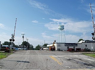
Waverly is an incorporated town in Sussex County, Virginia, United States. Per the 2020 census, the population was 1,955.

<span class="mw-page-title-main">Jarratt, Virginia</span> Town in Virginia, United States

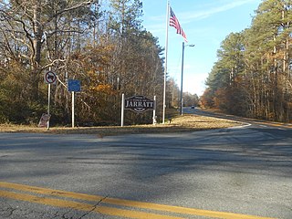
Jarratt is a town in Greensville and Sussex counties in the U.S. state of Virginia. The population was 652 at the 2020 census. In 1848, Jarratt was a stop on the Petersburg Railroad. Jaratt was incorporated in 1938.

<span class="mw-page-title-main">Surry County, Virginia</span> County in Virginia, United States

Surry County is a county in the southeastern part of the Commonwealth of Virginia. As of the 2020 census, the population was 6,561.

Sussex I State Prison is a prison of the Virginia Department of Corrections located in unincorporated Sussex County, Virginia, near Waverly. It is adjacent to Sussex II State Prison, which lies to its northwest, just across Mussellwhite Drive.

References

  1. "Sussex County, Virginia". United States Census Bureau . Retrieved January 30, 2022.
  2. "Find a County". National Association of Counties. Retrieved June 7, 2011.
  3. "Sussex County FAQ." Retrieved on December 10, 2013.
  4. Gary M. Williams, Sussex County, Virginia: A Heritage Recalled by the Land (Petersburg, Virginia: The Dietz Press, 2014) p. 2
  5. "The Big Sussex Forest Fire of Apr., 1943". Sussex-Surry Dispatch. Vol. 86, no. 14. Virginia Chronicle (Library of Virginia). April 4, 1963.
  6. Gary M. Williams, Sussex County, Virginia: A Heritage Recalled by the Land (Petersburg, Virginia: The Dietz Press 2014) pp. 235-236
  7. "US Gazetteer files: 2010, 2000, and 1990". United States Census Bureau. February 12, 2011. Retrieved April 23, 2011.
  8. "Annual Estimates of the Resident Population for Counties: April 1, 2020 to July 1, 2021" . Retrieved April 6, 2022.
  9. "Census of Population and Housing from 1790-2000". US Census Bureau . Retrieved January 24, 2022.
  10. "Historical Census Browser". University of Virginia Library. Retrieved January 5, 2014.
  11. "Population of Counties by Decennial Census: 1900 to 1990". United States Census Bureau. Retrieved January 5, 2014.
  12. "Census 2000 PHC-T-4. Ranking Tables for Counties: 1990 and 2000" (PDF). United States Census Bureau. Retrieved January 5, 2014.
  13. 1 2 "P2 Hispanic or Latino, and Not Hispanic or Latino by Race – 2010: DEC Redistricting Data (PL 94-171) - Sussex County, Virginia". United States Census Bureau .
  14. 1 2 "P2 Hispanic or Latino, and Not Hispanic or Latino by Race – 2020: DEC Redistricting Data (PL 94-171) - Sussex County, Virginia". United States Census Bureau .
  15. "P004 Hispanic or Latino, and Not Hispanic or Latino by Race – 2000: DEC Summary File 1 – Sussex County, Virginia". United States Census Bureau.
  16. "U.S. Census website". United States Census Bureau . Retrieved May 14, 2011.
  17. Sommerstein, David. "Urban, Rural Areas Battle For Census Prison Populace." NPR . February 15, 2010. Retrieved on January 3, 2012. "In the early 2000s, southern Virginia's Sussex County was the fastest-growing county in the nation, according to the census. But the county had opened two prisons in the late 1990s — and if their residents weren't included, the county's population had actually declined, the Washington Post reported."
  18. "Sussex I State Prison Archived November 6, 2013, at the Wayback Machine ." Virginia Department of Corrections. Retrieved on August 22, 2010.
  19. "Sussex II State Prison." Virginia Department of Corrections. Retrieved on January 3, 2013.
  20. "DOC Appoints New Warden at Sussex I State Prison Archived November 6, 2013, at the Wayback Machine ." Virginia Department of Corrections. March 9, 2006. Retrieved on August 22, 2010.
  21. "Virginia Death Row/Execution Facts." My FOX DC. Tuesday November 10, 2009. Retrieved on August 22, 2010.
  22. Leip, David. "Dave Leip's Atlas of U.S. Presidential Elections". uselectionatlas.org. Retrieved December 9, 2020.

36°56′N77°16′W / 36.93°N 77.26°W / 36.93; -77.26