
Courtland is an incorporated town in Southampton County, Virginia, United States. It is the county seat of Southampton County.

Sussex County is a rural county located in the southeast of the Commonwealth of Virginia. As of the 2020 census, the population was 10,829. Its county seat is Sussex. It was formed in 1754 from Surry County. The county is named after the county of Sussex, England.

Minisink Archeological Site, also known as Minisink Historic District, is an archeological site of 1320 acres located in both Sussex County, New Jersey and Pike County, Pennsylvania. It was part of a region occupied by Munsee-speaking Lenape that extended from southern New York across northern New Jersey to northeastern Pennsylvania. The Munsee were speakers of one of the three major language dialects of the Lenape Native American tribe. This interstate territory became the most important Munsee community for the majority of the 17th and 18th centuries.

Staunton River Battlefield State Park is a state park located in Virginia. The park straddles the Staunton River in Halifax and Charlotte counties. The Roanoke visitor center in Randolph, Virginia is a railroad depot which now holds exhibits on Native Americans and railroad history. The Clover visitor center has exhibits on the American Civil War and the battle which took place on this site. It also includes information about the production of electric energy. The park also includes the Mulberry Hill plantation, given to the state in 1999.

This is a list of the National Register of Historic Places listings in Nottoway County, Virginia.

The Canfield Island Site, also known as Archeological Site 36LY37, is an archaeological site in Lycoming County, Pennsylvania, United States. Located on Canfield Island in the West Branch Susquehanna River, the site lies east of the city of Williamsport in Loyalsock Township. It is believed to have been inhabited by prehistoric Native Americans for thousands of years, with the oldest discoveries dating back to more than one millennium before Christ.

Boone's Mounds are a ceremonial site of the Coles Creek culture located in Calhoun County, Arkansas. The site is one of the largest mound sites in the Ouachita River valley. Archeological excavation at the site has yielded dates of occupation as early as 600 AD, and it may still have been in use during the early contact period, c. 1700. The site was located on private property at the time of its listing on the National Register of Historic Places in 1980.
The Archeological Site No. 44JC308 is a historic archaeological site located near Williamsburg, Virginia. The site encompasses a Paspahegh Native American Village (44JC308) that is currently occupied by the Two Rivers Country Club 18th fairway and green. Archeological findings suggest that the Paspahegh village was established sometime after 1500 AD and occupied during the period of sustained contact between Europeans and native peoples following the establishment of the English settlement at Jamestown in 1607.
The Beaver Meadow Brook Archeological Site is a prehistoric Native American village or camp site in New Hampshire. Located near Sewall's Falls on the west bank of the Merrimack River, the site includes evidence of occupation during Middle and Late Archaic periods, as well as during the Woodland precontact period. Finds at the site include a stone axe and numerous tools for working stone, as well as projectile points and bone fragments. The site also has several hearths, evidence of significant occupation during the Woodland period.
The Conover Archaeological Site is a prehistoric Native American site located in Dinwiddie County, Virginia, near the community of Carson. It is one of the few sites in Virginia which is documented to date to c. 9500 BCE. The large number of stone artifacts found at this site, including tools for working stone and stone tool manufacturing byproducts, suggest this site was used as a quarry or maintenance site by paleo-Indians.

The Woodlawn Historic and Archeological District encompasses a historic plantation near the Rappahannock River in southern King George County, Virginia. The 899-acre (364 ha) property is located east of US Route 301 near Port Conway. The estate boundaries are essentially the same as those when the plantation was first established in 1790. The main plantation house dates to that time although it has been extended and altered over the intervening centuries. Also of notable interest on this property are surviving antebellum slave quarters, and archaeological sites containing evidence of Native American occupation of the land.
The Hampstead Farm Archeological District is the site of a significant collection of Native American prehistoric and historic settlement remains in rural Orange County, Virginia. A survey of the farm's 780 acres (320 ha) in 1983 identified 49 different sites of archaeological interest. Sites were found near the adjoining Rapidan River, as well as in upland areas of the farm. Along with sites found at the nearby Montpelier estate, the upland sites demonstrate the significance of that area in Native American occupation patterns. Test pits dug near the river located well-preserved settlement sites at a depth of up to 2 metres (6.6 ft). The farm is also the location of minor military fortifications from the American Civil War.

The Cornett Archeological Site (44WY1) is a prehistoric and historic Native American site in Wythe County, Virginia. The site is located on a terrace above the north bank of the New River, about 0.5 miles (0.80 km) outside Austinville. It is a village site, which was occupied during the Late Woodland period, and offers evidence of significantly earlier occupation. The village had a well-defined plaza area, and may have been surrounded by a palisade. Formal excavations of the site have recovered pottery sherds, stone tools, and ceramic and metal trade items. The site has also been subjected to excavations by local collectors.

The Martin Site (44WY13) is a prehistoric Native American village site in Wythe County, Virginia, United States. It is located on the banks of the New River near the community of Fosters Falls. The site has clear evidence of occupation during the Late Woodland period, and offers evidence of older occupation. Finds at the site include pottery sherds, stone tools, ceramic and shell trade items, and grave sites.

The Madison Farm Historic and Archeological District is a complex of historic and prehistoric Native American and colonial sites in rural Montgomery County, Virginia. It is located in and near the flood plains of the South Fork of the Roanoke River, and covers 115 acres (47 ha). Its historic artifacts include a surviving hall-parlor log house, probably built late in the 18th century by William Madison, which is one of the few of its type to survive in the county. The building was substantially modified in the 19th century, refinishing the interior and adding a two-story porch. The farm site includes a number of historic outbuildings, and is a good prospect for archaeological investigation into period farming practices.
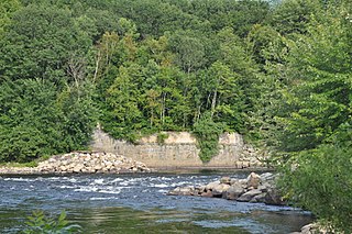
The Leesville Dam Archaeological Site is a prehistoric Native American village site in Pittsylvania County, Virginia, near the town of Altavista. The site is located in the general vicinity of the Roanoke River, and is one of the most important Late Woodland period village sites in the area. It was listed on the National Register of Historic Places in 1989, at which time the site was covered by an agricultural field.

The Hunter Archeological Site is a significant prehistoric Native American site in Claremont, New Hampshire. Located near the bridge connecting Claremont and Ascutney, Vermont, the site includes seven levels of occupational evidence, including evidence of at least three longhouses. The oldest dates recorded from evidence gathered during excavations in 1967 were to AD 1300. The site was listed on the National Register of Historic Places in 1976.

Aquadoctan was one of the largest known Native American villages in what is now the U.S. state of New Hampshire. In an area commonly known today as The Weirs, the village lay on the north bank of the Winnipesaukee River at the outlet of Lake Winnipesaukee in the Lakes Region of New Hampshire. The site is now in Weirs Beach, a summer resort and village of the city of Laconia. The Native American village, whose archaeological remains extend for a half mile along the river and a quarter mile along the lake, has been documented through archaeological investigation to have evidence of settlement from 9,000 BCE to the late seventeenth century. Colonial reports document that the site was abandoned substantially in 1696, when most of New Hampshire's remaining native population withdrew to join the Pequawket at present-day Fryeburg, Maine.
Archeological Site No. 74-2 is a prehistoric site in Indian Island, Maine. Located on a terrace above the Penobscot River, the site dates to the Middle Archaic Period, a rarity in Maine, made even more unusual by the absence of later period artifacts. The site was listed on the National Register of Historic Places in 1984, for its potential to increase what is known about Native settlement patterns in the area.
The Winooski Archeological Site, designated VT-CH-46 by state archaeologists, is a prehistoric Native American site in the city of Winooski, Vermont. First identified in 1972, it is one of the largest Native encampment sites of the Middle Woodland period in the northeastern United States. It was listed on the National Register of Historic Places in 1978, at which time it was recognized as one of just two stratified Woodland period sites in the state.

