King and Queen County, Virginia

Last updated

King and Queen County
KING AND QUEEN COURTHOUSE GREEN HISTORIC DISTRICT.jpg
Old King and Queen County Courthouse
Flag of King and Queen County, Virginia.png
King and Queen County, Virginia seal.png
Map of Virginia highlighting King and Queen County.svg
Location within the U.S. state of Virginia
Virginia in United States.svg
Virginia's location within the U.S.
Coordinates: 37°43′N76°54′W / 37.72°N 76.9°W / 37.72; -76.9
CountryFlag of the United States.svg United States
StateFlag of Virginia.svg  Virginia
Founded1691
Named for William III and Mary II of England
Seat King and Queen Court House
Area
  Total326 sq mi (840 km2)
  Land315 sq mi (820 km2)
  Water11 sq mi (30 km2)  3.4%
Population
 (2020)
  Total6,608
  Density20/sq mi (7.8/km2)
Time zone UTC−5 (Eastern)
  Summer (DST) UTC−4 (EDT)
Congressional district 1st
Website www.kingandqueenco.net

King and Queen County is a county in the U.S. state of Virginia, located in the state's Middle Peninsula on the eastern edge of the Richmond, VA, metropolitan area. As of the 2020 census, the population was 6,608. [1] Its county seat is King and Queen Court House. [2]

Contents

History

King and Queen County was established in 1691 from New Kent County, and was named for King William III and Queen Mary II of England. [3] King and Queen County is notable as one of the few counties in the United States to have recorded a larger population in the 1790 census than in the 2010 one.

Among the earliest settlers of King and Queen County was Roger Shackelford, an English emigrant from Old Alresford, Hampshire, after whom the county's village of Shacklefords is named. Shackelford's descendants continued to live in the county, and by the nineteenth century had intermarried with several local families, including Taliaferro, Beverley, Thornton, and Sears. [4]

In 1762 when he was 11, future president James Madison was sent to a boarding school run by Donald Robertson at the Innes plantation in King and Queen County. Robertson was a Scottish teacher who tutored numerous prominent plantation families in the South. From Robertson, Madison learned mathematics, geography, and modern and classical languages, becoming especially proficient in Latin. He attributed his instinct for learning "largely to that man (Robertson)." [5] [6] At age 16, Madison returned to his father's Montpelier estate in Orange County.

On March 2, 1864, the Battle of Walkerton, an engagement of the American Civil War, took place here, resulting in a Confederate victory.

Virginia Longest, national director of the Nursing Service for the U.S. Department of Veterans Affairs in the late 1970s, was a county native.

Richard and Mildred Loving lived in a remote part of the county in the 1960s, hoping to avoid arrest by the authorities while their legal challenge to Virginia's anti-miscegenation laws moved through the courts.

For many years, county publications noted that the county lacked any traffic lights. This is now no longer the case, as a traffic light has been installed on U.S. Route 360 at St. Stephen's Church.

Even in the 21st century, King and Queen County contains no incorporated towns or cities, and remains one of Virginia's most sparsely populated counties.

Geography

According to the U.S. Census Bureau, the county has a total area of 326 square miles (840 km2), of which 315 square miles (820 km2) is land and 11 square miles (28 km2) (3.4%) is water. [7]

Measuring 45 miles (72 km) in length, it is one of the longest counties in the state of Virginia, as well as one of the narrowest, measuring less than 10 miles (16 km) across at its widest point.

Adjacent Counties

Major highways

Demographics

Historical population
CensusPop.Note
1790 9,377
1800 9,8795.4%
1810 10,98811.2%
1820 11,7987.4%
1830 11,644−1.3%
1840 10,862−6.7%
1850 10,319−5.0%
1860 10,3280.1%
1870 9,709−6.0%
1880 10,5028.2%
1890 9,669−7.9%
1900 9,265−4.2%
1910 9,5763.4%
1920 9,161−4.3%
1930 7,618−16.8%
1940 6,954−8.7%
1950 6,299−9.4%
1960 5,889−6.5%
1970 5,491−6.8%
1980 5,9688.7%
1990 6,2895.4%
2000 6,6305.4%
2010 6,9454.8%
2020 6,608−4.9%
2021 (est.)6,662 [8] 0.8%
U.S. Decennial Census [9]
1790–1960 [10] 1900–1990 [11]
1990–2000 [12] 2010 [13] 2020 [14]

2020 census

King and Queen County, Virginia – Racial and ethnic composition
Note: the US Census treats Hispanic/Latino as an ethnic category. This table excludes Latinos from the racial categories and assigns them to a separate category. Hispanics/Latinos may be of any race.
Race / Ethnicity (NH = Non-Hispanic)Pop 2010 [13] Pop 2020 [14] % 2010% 2020
White alone (NH)4,5474,46065.47%67.49%
Black or African American alone (NH)1,9701,56128.37%23.62%
Native American or Alaska Native alone (NH)109821.57%1.24%
Asian alone (NH)17230.24%0.35%
Pacific Islander alone (NH)030.00%0.05%
Some Other Race alone (NH)7190.10%0.29%
Mixed Race or Multi-Racial (NH)1112781.60%4.21%
Hispanic or Latino (any race)1841822.65%2.75%
Total6,9456,608100.00%100.00%

2000 Census

As of the census [15] of 2000, there were 6,630 people residing in the county; these included 2,673 households and 1,897 families. The population density was 21 people per square mile (8.1 people/km2). There were 3,010 housing units, at an average density of 10 units per square mile (3.9 units/km2). The racial makeup of the county was 61.22% White, 35.67% Black or African American, 1.42% Native American, 0.27% Asian, 0.02% Pacific Islander, 0.15% from other races, and 1.25% from two or more races. 0.87% of the population were Hispanic or Latino of any race.

Of the 2,673 households, 26.80% had children under the age of 18 living with them, 52.60% were married couples living together, 13.50% had a female householder with no husband present, and 29.00% were non-families. 24.60% of all households were made up of individuals, and 11.00% had someone living alone who was 65 years of age or older. The average household size was 2.48 and the average family size was 2.94.

The median age in the county was 41 years, with 22.70% under the age of 18, 7.00% from 18 to 24, 26.80% from 25 to 44, 27.00% from 45 to 64, and 16.40% who were 65 years of age or older. For every 100 females, there were 95.20 males. For every 100 females age 18 and over, there were 92.50 males.

The median household income was $35,941, and the median family income was $40,563. Males had a median income of $33,217, versus $21,753 for females. The per capita income for the county was $17,236. 10.90% of the population and 7.80% of families were below the poverty line. Of the total people living in poverty, 8.10% were under the age of 18 and 14.80% were 65 or older.

Government

Board of Supervisors

Constitutional officers

King and Queen is represented by Republican Thomas K. "Tommy" Norment in the Virginia Senate, Republican M. Keith Hodges in the Virginia House of Delegates, and Republican Robert J. "Rob" Wittman in the U.S. House of Representatives.

Presidentially, King and Queen County is a bellwether county of sorts. It correctly predicted the winner of all but four presidential elections between 1928 and 2020, voting for losing candidates only in 1968, 1980, 2012, and 2020.

United States presidential election results for King and Queen County, Virginia [16]
Year Republican Democratic Third party
No.%No.%No.%
2020 2,45059.54%1,59038.64%751.82%
2016 2,09956.88%1,46839.78%1233.33%
2012 1,86551.03%1,74547.74%451.23%
2008 1,76347.58%1,91851.77%240.65%
2004 1,73752.86%1,50645.83%431.31%
2000 1,42349.77%1,38748.51%491.71%
1996 1,07338.93%1,39350.54%29010.52%
1992 1,20641.34%1,36346.73%34811.93%
1988 1,37650.46%1,30948.00%421.54%
1984 1,44954.39%1,20145.08%140.53%
1980 94944.14%1,12852.47%733.40%
1976 77839.06%1,11155.77%1035.17%
1972 1,03358.30%70839.95%311.75%
1968 56827.40%88242.55%62330.05%
1964 69946.94%78652.79%40.27%
1960 43243.95%53654.53%151.53%
1956 49554.64%28931.90%12213.47%
1952 41551.23%38747.78%80.99%
1948 17131.26%29353.56%8315.17%
1944 16631.38%36368.62%00.00%
1940 12425.31%36574.49%10.20%
1936 12424.95%37274.85%10.20%
1932 15428.79%36868.79%132.43%
1928 31953.26%28046.74%00.00%
1924 13429.65%31469.47%40.88%
1920 18134.28%34765.72%00.00%
1916 12731.91%27168.09%00.00%
1912 6818.78%24667.96%4813.26%

Communities

See also

Related Research Articles

<span class="mw-page-title-main">Morgan County, Alabama</span> County in Alabama, United States

Morgan County is a county in the north-central part of the U.S. state of Alabama. As of the 2020 census, its population was 123,421. The county seat is Decatur. On June 14, 1821, it was renamed in honor of American Revolutionary War General Daniel Morgan of Virginia. It is a prohibition or dry county, although alcohol sales are allowed in the cities of Decatur, Hartselle, and Priceville. Morgan County is included in the Decatur, AL Metropolitan Statistical Area, which is also included in the Huntsville-Decatur-Albertville, AL Combined Statistical Area. It is a part of the North, Northwest, and North-Central regions of Alabama.

<span class="mw-page-title-main">Marshall County, Alabama</span> County in Alabama, United States

Marshall County is a county of the state of Alabama, United States. As of the 2020 census the population was 97,612. Its county seat is Guntersville. A second courthouse is in Albertville. Its name is in honor of John Marshall, famous Chief Justice of the United States. Marshall County is a dry county, with the exception of the five cities of Albertville, Arab, Grant, Guntersville, and Boaz. Marshall County comprises the Albertville, AL Micropolitan Statistical Area, which is also included in the Huntsville-Decatur-Albertville, AL Combined Statistical Area.

<span class="mw-page-title-main">Washington County, Virginia</span> County in Virginia, United States

Washington County is a county located in the Commonwealth of Virginia. As of the 2020 census, the population was 53,935. Its county seat is Abingdon.

<span class="mw-page-title-main">Smyth County, Virginia</span> County in Virginia, United States

Smyth County is a county located in the U.S. state of Virginia. As of the 2020 census, the population was 29,800. Its county seat is Marion.

<span class="mw-page-title-main">Nottoway County, Virginia</span> County in Virginia, United States

Nottoway County is a county located in the Commonwealth of Virginia. As of the 2020 census, the population was 15,642. Its county seat is Nottoway. It is situated south of the James River, thus making it a part of the Southside Virginia Region.

<span class="mw-page-title-main">Madison County, Virginia</span> County in Virginia, United States

Madison County is a county located in the Commonwealth of Virginia. As of the 2020 census, the population was 13,837. Its county seat is Madison.

<span class="mw-page-title-main">King George County, Virginia</span> County in Virginia, United States

King George County is a county located in the Commonwealth of Virginia. As of the 2020 census, the population sits at 26,723. Its county seat is the town of King George.

<span class="mw-page-title-main">Essex County, Virginia</span> County in Virginia, United States

Essex County is a county located in the Middle Peninsula in the U.S. state of Virginia; the peninsula is bordered by the Rappahannock River on the north and King and Queen County on the south. As of the 2020 census, the population was 10,599. Its county seat is Tappahannock.

<span class="mw-page-title-main">Leon County, Texas</span> County in Texas, United States

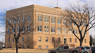
Leon County is a county in the U.S. state of Texas. As of the 2020 census, its population was 15,719. Its county seat is Centerville.

<span class="mw-page-title-main">Callahan County, Texas</span> County in Texas, United States

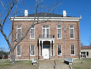
Callahan County is a county located in the U.S. state of Texas. As of the 2020 census, the population was 13,708. Its county seat is Baird. The county was founded in 1858 and later organized in 1877. It is named for James Hughes Callahan, an American soldier in the Texas Revolution. Callahan County is included in the Abilene, Texas metropolitan statistical area.

<span class="mw-page-title-main">Madison County, Ohio</span> County in Ohio, United States

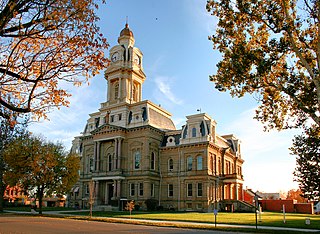
Madison County is a county located in the central portion of the U.S. state of Ohio. As of the 2020 census, the population was 43,824. Its county seat is London. The county is named for James Madison, President of the United States and was established on March 1, 1810.

<span class="mw-page-title-main">Clarke County, Iowa</span> County in Iowa, United States

Clarke County is a county located in the U.S. state of Iowa. As of the 2020 census, the population was 9,748. The county seat is Osceola. The county was formed in January 1846, one of twelve counties established by legislative action in a comprehensive act. It was named for James Clarke, a Governor of the Iowa Territory.

<span class="mw-page-title-main">Madison, Illinois</span> City in Illinois, United States

Madison is a city in Madison and St. Clair counties in the U.S. state of Illinois. The population was 3,171 at the 2020 census, down from 3,891 in 2010. It is home to World Wide Technology Raceway at Gateway and the first Bulgarian Orthodox church in the United States.

<span class="mw-page-title-main">Venice, Illinois</span> City in Illinois, United States

Venice is a city in Madison County, Illinois, United States. The population was 1,498 at the 2020 census, down from 1,890 in 2010.

<span class="mw-page-title-main">Rushmere, Virginia</span> Census-designated place in Virginia, United States

Rushmere is a census-designated place (CDP) in Isle of Wight County, Virginia, United States. The population was 1,018 at the 2010 census.

<span class="mw-page-title-main">Madison, West Virginia</span> City in West Virginia, United States

Madison is a city and former coal town in Boone County, West Virginia, United States. The population was 2,911 at the 2020 census. It is the county seat of Boone County.

<span class="mw-page-title-main">Northfork, West Virginia</span> Town in West Virginia, United States

Northfork is a town in McDowell County, West Virginia, United States, located on U.S. Route 52 between Welch and Bluefield.

<span class="mw-page-title-main">Calverton, Maryland</span> Census-designated place in Maryland, United States

Calverton is an unincorporated area and census-designated place located on the boundary between Montgomery and Prince George's counties, Maryland, in the United States. At the 2020 census, it had a population of 17,316.

<span class="mw-page-title-main">Dranesville, Virginia</span> Census-designated place in Virginia, United States

Dranesville is a census-designated place (CDP) in Fairfax County, Virginia, United States. Dranesville is located on the Leesburg Pike at its intersection with Georgetown Pike. The U.S. Census Bureau defines Dranesville as a census-designated place (CDP) with a population of 11,921 as of 2010. At the 2020 Census the population was 11,785.

<span class="mw-page-title-main">King William County, Virginia</span> County in Virginia, United States

King William County is a county located in the U.S. state of Virginia. As of the 2020 census, the population was 17,810. Its county seat is King William.

References

  1. "King and Queen County, Virginia". United States Census Bureau . Retrieved January 30, 2022.
  2. "Find a County". National Association of Counties. Archived from the original on May 31, 2011. Retrieved June 7, 2011.
  3. Henry Gannett (1905). The Origin of Certain Place Names in the United States. Govt. Print. Off. pp.  175.
  4. Bagby, Alfred (April 10, 2018). King and Queen County, Virginia. Neale Publishing Company. ISBN   9780722246290 . Retrieved April 10, 2018 via Google Books.
  5. Boyd-Rush, Dorothy. "Molding a founding father". James Madison University. Retrieved March 25, 2013.
  6. "James Madison's Biography". The Montpelier Foundation. Retrieved March 25, 2013.
  7. "US Gazetteer files: 2010, 2000, and 1990". United States Census Bureau. February 12, 2011. Retrieved April 23, 2011.
  8. "Annual Estimates of the Resident Population for Counties: April 1, 2020 to July 1, 2021" . Retrieved April 6, 2022.
  9. "Census of Population and Housing from 1790-2000". US Census Bureau . Retrieved January 24, 2022.
  10. "Historical Census Browser". University of Virginia Library. Retrieved January 3, 2014.
  11. "Population of Counties by Decennial Census: 1900 to 1990". United States Census Bureau. Retrieved January 3, 2014.
  12. "Census 2000 PHC-T-4. Ranking Tables for Counties: 1990 and 2000" (PDF). United States Census Bureau. Archived (PDF) from the original on October 9, 2022. Retrieved January 3, 2014.
  13. 1 2 "P2 Hispanic or Latino, and Not Hispanic or Latino by Race – 2010: DEC Redistricting Data (PL 94-171) - King and Queen County, Virginia". United States Census Bureau .
  14. 1 2 "P2 Hispanic or Latino, and Not Hispanic or Latino by Race – 2020: DEC Redistricting Data (PL 94-171) - King and Queen County, Virginia". United States Census Bureau .
  15. "U.S. Census website". United States Census Bureau . Retrieved May 14, 2011.
  16. Leip, David. "Dave Leip's Atlas of U.S. Presidential Elections". uselectionatlas.org. Retrieved December 9, 2020.

37°43′N76°54′W / 37.72°N 76.90°W / 37.72; -76.90