Lunenburg County, Virginia

Last updated

Lunenburg County
LunenburgCourthouse2018.jpg
Lunenburg County Courthouse
Lunenburg Seal.jpg
Motto: 
The Old Free State
Map of Virginia highlighting Lunenburg County.svg
Location within the U.S. state of Virginia
Virginia in United States.svg
Virginia's location within the U.S.
Coordinates: 36°57′N78°14′W / 36.95°N 78.24°W / 36.95; -78.24
CountryFlag of the United States.svg United States
StateFlag of Virginia.svg  Virginia
Founded1746
Named for Brunswick-Lüneburg
Seat Lunenburg
Largest town Victoria
Area
  Total432 sq mi (1,120 km2)
  Land432 sq mi (1,120 km2)
  Water0.7 sq mi (2 km2)  0.2%
Population
 (2020)
  Total11,936
  Density28/sq mi (11/km2)
Time zone UTC−5 (Eastern)
  Summer (DST) UTC−4 (EDT)
Congressional district 5th
Website www.lunenburgva.org

Lunenburg County is a county located in the Commonwealth of Virginia. As of the 2020 census, the population was 11,936. [1] Its county seat is Lunenburg. [2]

Contents

History

Lunenburg County was established on May 1, 1746, from Brunswick County. The county is named for the former Duchy of Brunswick-Lünenburg [3] in Germany, because one of the titles also carried by Britain's Hanoverian kings was Duke of Brunswick-Lünenburg. Bedford, Charlotte, Halifax, and Mecklenburg Counties were later formed from Lunenburg County. It is nicknamed "The Old Free State" because during the buildup of the Civil War, it let Virginia know the county would break off if the state did not join The Confederacy. [4]

Among the earliest settlers of the county was William Taylor, born in King William County, Virginia. He was the son of Rev. Daniel Taylor, a Virginia native and Anglican priest educated at Trinity College, Cambridge University [5] in England, and his wife Alice (Littlepage) Taylor. William Taylor married Martha Waller, a daughter of Benjamin Waller of Williamsburg, Virginia. [6]

In 1760 Taylor purchased three adjoining tracts of land in Lunenburg County totaling 827 acres (3.35 km2). Taylor soon became one of the county's leading citizens, representing Lunenburg in the Virginia House of Burgesses from 1765 until 1768. [7] In that capacity, Taylor voted in 1765 to support statesman Patrick Henry's Virginia Resolves in 1765. [8] Taylor served as County Clerk for 51 years (1763–1814).

Taylor was succeeded as County Clerk by his son William Henry Taylor, who held the office for another 32 years—from 1814 until 1846. Another son, General Waller Taylor, represented Lunenburg in the Virginia legislature, then moved to Vincennes, Indiana. There he became a judge and subsequently Adjutant General of the United States Army under General William Henry Harrison in the War of 1812. General Waller Taylor later served as one of the first United States senators from the newly created state of Indiana from 1816 to 1825. He died on a visit home to see his relatives in Lunenburg County in 1826. [9]

During much of the American Civil War, the family of Missionary Bishop Henry C. Lay lived in Lunenberg County, where Mrs. Lay (the former Eliza Withers Atkinson) grew up. Both of Bishop Lay's brothers served as Confederate colonels, and Mrs. Lay's uncle, Thomas Atkinson was bishop of North Carolina.

Cases surrounding an 1895 Lunenburg County murder are the subject of historian Suzanne Lebsock's book, A Murder in Virginia: Southern Justice on Trial .

Geography

According to the U.S. Census Bureau, the county has a total area of 432 square miles (1,120 km2), of which 432 square miles (1,120 km2) is land and 1 square mile (2.6 km2) (0.16%) is water.

Adjacent counties

Major highways

Demographics

Historical population
CensusPop.Note
1790 8,959
1800 10,38115.9%
1810 12,26518.1%
1820 10,662−13.1%
1830 11,95712.1%
1840 11,055−7.5%
1850 11,6925.8%
1860 11,9832.5%
1870 10,403−13.2%
1880 11,53510.9%
1890 11,372−1.4%
1900 11,7052.9%
1910 12,7809.2%
1920 15,26019.4%
1930 14,058−7.9%
1940 13,844−1.5%
1950 14,1162.0%
1960 12,523−11.3%
1970 11,687−6.7%
1980 12,1243.7%
1990 11,419−5.8%
2000 13,14615.1%
2010 12,914−1.8%
2020 11,936−7.6%
U.S. Decennial Census [10]
1790–1960 [11] 1900–1990 [12]
1990–2000 [13] 2010 [14] 2020 [15]

2020 census

Lunenburg County, Virginia – Racial and ethnic composition
Note: the US Census treats Hispanic/Latino as an ethnic category. This table excludes Latinos from the racial categories and assigns them to a separate category. Hispanics/Latinos may be of any race.
Race / Ethnicity (NH = Non-Hispanic)Pop 2010 [14] Pop 2020 [15] % 2010% 2020
White alone (NH)7,7307,01659.86%58.78%
Black or African American alone (NH)4,4513,77334.47%31.61%
Native American or Alaska Native alone (NH)37320.29%0.27%
Asian alone (NH)25250.19%0.21%
Pacific Islander alone (NH)350.02%0.04%
Some Other Race alone (NH)9310.07%0.26%
Mixed Race or Multi-Racial (NH)1894651.46%3.90%
Hispanic or Latino (any race)4705893.64%4.93%
Total12,91411,936100.00%100.00%

2000 Census

As of the census [16] of 2000, there were 13,146 people, 4,998 households, and 3,383 families residing in the county. The population density was 30 people per square mile (12 people/km2). There were 5,736 housing units at an average density of 13 units per square mile (5.0 units/km2). The racial makeup of the county was 59.12% White, 38.58% Black or African American, 0.16% Native American, 0.21% Asian, 0.05% Pacific Islander, 0.75% from other races, and 1.14% from two or more races. 1.79% of the population were Hispanic or Latino of any race.

There were 4,998 households, out of which 27.30% had children under the age of 18 living with them, 49.50% were married couples living together, 13.30% had a female householder with no husband present, and 32.30% were non-families. 28.70% of all households were made up of individuals, and 14.70% had someone living alone who was 65 years of age or older. The average household size was 2.39 and the average family size was 2.91.

In the county, the population was spread out, with 21.30% under the age of 18, 8.00% from 18 to 24, 28.10% from 25 to 44, 25.80% from 45 to 64, and 16.80% who were 65 years of age or older. The median age was 40 years. For every 100 females there were 113.80 males. For every 100 females aged 18 and over, there were 115.70 males.

The median income for a household in the county was $27,899, and the median income for a family was $34,302. Males had a median income of $26,496 versus $20,237 for females. The per capita income for the county was $14,951. About 14.90% of families and 20.00% of the population were below the poverty line, including 27.30% of those under age 18 and 22.80% of those age 65 or over.

Education

Lunenburg County Public Schools operates the following schools:

There are no private or independent schools in Lunenburg County, and no colleges or universities are located there. Kenston Forest School in Nottoway County, approximately 20 minutes away, offers the closest K-12 private education available to Lunenburg County residents.

Communities

Towns

Census-designated place

Other unincorporated communities

Notable people

Politics

United States presidential election results for Lunenburg County, Virginia [17]
Year Republican Democratic Third party
No.%No.%No.%
2020 3,53758.95%2,41840.30%450.75%
2016 3,20457.36%2,22739.87%1552.77%
2012 2,96951.78%2,68446.81%811.41%
2008 2,90051.33%2,70347.84%470.83%
2004 2,85854.49%2,36245.03%250.48%
2000 2,51054.67%2,02644.13%551.20%
1996 2,06346.26%1,99544.73%4029.01%
1992 2,22745.34%2,08242.39%60312.28%
1988 2,53056.27%1,87041.59%962.14%
1984 2,71359.94%1,75438.75%591.30%
1980 2,04549.44%1,95847.34%1333.22%
1976 1,81649.73%1,73947.62%972.66%
1972 2,46469.14%1,04429.29%561.57%
1968 1,18129.44%1,18029.41%1,65141.15%
1964 1,84762.04%1,12837.89%20.07%
1960 83835.22%1,45160.99%903.78%
1956 58024.80%1,11147.50%64827.70%
1952 83735.27%1,52864.39%80.34%
1948 25114.61%1,12665.54%34119.85%
1944 18413.21%1,20586.50%40.29%
1940 14410.60%1,21389.26%20.15%
1936 775.62%1,29194.23%20.15%
1932 927.38%1,14191.50%141.12%
1928 31420.75%1,19979.25%00.00%
1924 13012.55%68666.22%22021.24%
1920 20820.08%81878.96%100.97%
1916 11011.74%81486.87%131.39%
1912 6610.51%50880.89%548.60%

See also

Related Research Articles

<span class="mw-page-title-main">Washington County, Virginia</span> County in Virginia, United States

Washington County is a county located in the Commonwealth of Virginia. As of the 2020 census, the population was 53,935. Its county seat is Abingdon.

<span class="mw-page-title-main">Scott County, Virginia</span> County in Virginia, United States

Scott County is a county located in the far southwestern part of the U.S. state of Virginia, on the border with Tennessee. As of the 2020 census, the population was 21,576. Its county seat is Gate City. Scott County was formed by an act of the General Assembly on November 24, 1814, from parts of Washington, Lee, and Russell counties and was named for Virginia -born General Winfield Scott. Scott County is part of the Kingsport–Bristol–Bristol, TN-VA Metropolitan Statistical Area, which is a component of the Johnson City–Kingsport–Bristol, TN-VA Combined Statistical Area, commonly known as the "Tri-Cities" region. The County Administrator is Freda Russell Starnes.

<span class="mw-page-title-main">Richmond County, Virginia</span> County in Virginia, United States

Richmond County is a county located on the Northern Neck in the U.S. state of Virginia. As of the 2020 census, the population sits at 8,923. Its county seat is Warsaw. The rural county should not be confused with the large city and state capital Richmond, Virginia. It was formed in 1692 when the first Rappahannock County was divided to form Richmond County and Essex County.

<span class="mw-page-title-main">Pulaski County, Virginia</span> County in Virginia, United States

Pulaski County is a county located in the southwestern part of the U.S. state of Virginia. As of the 2020 census, the population was 33,800. Its county seat is Pulaski. Pulaski County is part of the Blacksburg–Christiansburg, VA Metropolitan Statistical Area.

<span class="mw-page-title-main">Nottoway County, Virginia</span> County in Virginia, United States

Nottoway County is a county located in the Commonwealth of Virginia. As of the 2020 census, the population was 15,642. Its county seat is Nottoway. It is situated south of the James River, thus making it a part of the Southside Virginia Region.

<span class="mw-page-title-main">Mecklenburg County, Virginia</span> County in Virginia, United States

Mecklenburg County is a county in the Commonwealth of Virginia. As of the 2020 census, the population was 30,319. Its county seat is Boydton.

<span class="mw-page-title-main">Manassas Park, Virginia</span> Independent city in Virginia, United States

Manassas Park is an independent city in the U.S. state of Virginia. As of the 2020 census, the population was 17,219. Manassas Park is bordered by the city of Manassas and Prince William County. Manassas Park is a part of the Washington-Arlington-Alexandria, DC-VA-MD-WV Metropolitan Statistical Area.

<span class="mw-page-title-main">Madison County, Virginia</span> County in Virginia, United States

Madison County is a county located in the Commonwealth of Virginia. As of the 2020 census, the population was 13,837. Its county seat is Madison.

<span class="mw-page-title-main">Isle of Wight County, Virginia</span> County in Virginia, United States

Isle of Wight County is a county located in the Hampton Roads region of the U.S. state of Virginia. It was named after the Isle of Wight, England, south of the Solent, from where many of its early colonists had come. As of the 2020 census, the population was 38,606. Its county seat is Isle of Wight, an unincorporated community.

<span class="mw-page-title-main">Halifax County, Virginia</span> County in Virginia, United States

Halifax County is a county located in the Commonwealth of Virginia. As of the 2020 census, the population was 34,022. Its county seat is Halifax.

<span class="mw-page-title-main">Greensville County, Virginia</span> County in Virginia, United States

Greensville County is a county located in the Commonwealth of Virginia. As of the 2020 census, the population was 11,391. Its county seat is Emporia.

<span class="mw-page-title-main">Giles County, Virginia</span> County in Virginia, United States

Giles County is a county located in the U.S. state of Virginia on the West Virginia state line. As of the 2020 census, the population was 16,787. Its county seat is Pearisburg.

<span class="mw-page-title-main">Charlotte County, Virginia</span> County in Virginia, United States

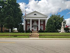
Charlotte County is a United States county located in the south central part of the Commonwealth of Virginia. Its county seat is the town of Charlotte Court House. As of the 2020 census, the county population was 11,529. Charlotte County is predominantly rural with a population density of only 26.5 persons per square mile.

<span class="mw-page-title-main">Brunswick County, Virginia</span> County in Virginia, United States

Brunswick County is a United States county located on the southern border of the Commonwealth of Virginia. This rural county is known as one of the claimants to be the namesake of Brunswick stew. Brunswick County was created in 1720 from parts of Prince George, Surry and Isle of Wight counties. The county was named for the former Duchy of Brunswick-Lunenburg, the region from which the British monarchs of the House of Hanover originated. As of the 2020 census, the county population was 15,849. The Brunswick county seat is Lawrenceville.

<span class="mw-page-title-main">Amherst County, Virginia</span> County in Virginia, United States

Amherst County is a county, located in the Piedmont region and near the center of the Commonwealth of Virginia in the United States. The county is part of the Lynchburg Metropolitan Statistical Area, and its county seat is also named Amherst.

<span class="mw-page-title-main">Amelia County, Virginia</span> County in Virginia, United States

Amelia County is a county located just southwest of Richmond in the Commonwealth of Virginia, United States. The county is located in Central Virginia and is included in the Greater Richmond Region. Its county seat is Amelia Court House.

<span class="mw-page-title-main">Northampton County, North Carolina</span> County in North Carolina, United States

Northampton County is a county located in the U.S. state of North Carolina. As of the 2020 census, the population was 17,471. Its county seat is Jackson.

<span class="mw-page-title-main">Kenbridge, Virginia</span> Town in Virginia, United States

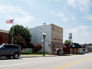
Kenbridge is a town in Lunenburg County, Virginia, United States. The population was 1,257 at the 2010 census. It is in a tobacco farming area. The area is home to noted folk artist Eldridge Bagley. The town is home to the Lunenburg Girls’ Softball league, Lunenburg Lightning Football and Cheerleading league and the United Futbol Soccer league. There are many quaint shops and boutiques and many family-owned businesses. Home to Kenbridge Elementary School. Visit www.kenbridgeva.net for information.

<span class="mw-page-title-main">Victoria, Virginia</span> Town in Virginia, United States

Victoria is an incorporated town in Lunenburg County, Virginia, United States. The population was 1,725 at the 2010 census, which was down from the 1,821 reported in 2000.

<span class="mw-page-title-main">Lunenburg, Massachusetts</span> Town in Massachusetts, United States

Lunenburg is a town in Worcester County, Massachusetts, United States. The population was 11,946 at the 2020 census.

References

  1. "Lunenburg County, Virginia". United States Census Bureau . Retrieved January 30, 2022.
  2. "Find a County". National Association of Counties. Retrieved June 7, 2011.
  3. Gannett, Henry (1905). The Origin of Certain Place Names in the United States. U.S. Government Printing Office. p. 192.
  4. The Old Free State: A Contribution to the History of Lunenburg County and Southside Virginia. Landon Covington Bell. 1927. Pp. 578ff. Reprint: 1974, 2005, Genealogical Publishing Company. ISBN   9780806306230. Google Books.
  5. Admissions to the College of St. John the Evangelist in the University of Cambridge, Part III, Robert Forsyth Scott, The University Press, Cambridge, 1903
  6. Listing: "Rev. Daniel Taylor", Virginia Magazine of History and biography, Vol. VIII, Virginia Historical Society, Printed by William Ellis Jones, Richmond, Va., 1901
  7. Lyon Gardiner Tyler, Encyclopedia of Virginia Biography, Vol. I, Lewis Historical Publishing Company, New York, 1915
  8. At his death in 1820, a Richmond newspaper noted in its obituary of William Taylor that he was the last man known to be alive who had heard Patrick Henry's famous "Give me liberty or give me death" speech in the Virginia House of Burgesses.
  9. Pattie B. Seay, Survey Report, The Taylor Cemetery Archived February 19, 2012, at the Wayback Machine , Library of Virginia Digital Collection
  10. "Census of Population and Housing from 1790-2000". US Census Bureau . Retrieved January 24, 2022.
  11. "Historical Census Browser". University of Virginia Library. Retrieved January 3, 2014.
  12. "Population of Counties by Decennial Census: 1900 to 1990". United States Census Bureau. Retrieved January 3, 2014.
  13. "Census 2000 PHC-T-4. Ranking Tables for Counties: 1990 and 2000" (PDF). United States Census Bureau. Archived (PDF) from the original on March 27, 2010. Retrieved January 3, 2014.
  14. 1 2 "P2 Hispanic or Latino, and Not Hispanic or Latino by Race – 2010: DEC Redistricting Data (PL 94-171) - Lunenburg County, Virginia". United States Census Bureau .
  15. 1 2 "P2 Hispanic or Latino, and Not Hispanic or Latino by Race – 2020: DEC Redistricting Data (PL 94-171) - Lunenburg County, Virginia". United States Census Bureau .
  16. "U.S. Census website". United States Census Bureau . Retrieved May 14, 2011.
  17. Leip, David. "Dave Leip's Atlas of U.S. Presidential Elections". uselectionatlas.org. Retrieved December 9, 2020.

36°57′N78°14′W / 36.95°N 78.24°W / 36.95; -78.24