Monacan Indian Nation and other SiouanTutelo-speaking tribes had lived in the area for over 10,000 years, driving the Virginia Algonquians eastward to the coastal areas.[6] Explorer John Lederer visited one of the Siouan villages (Saponi) in 1670, on the Staunton River at Otter Creek, southwest of the present-day city, as did the Thomas Batts and Robert Fallam expedition in 1671.
Siouan peoples occupied this area until about 1702; they had become weakened because of high mortality from infectious diseases. The Seneca people, who were part of the Haudenosaunee, or Iroquois Confederacy based in New York, defeated them. The Seneca had ranged south while seeking new hunting grounds through the Shenandoah Valley to the West. At the Treaty of Albany in 1718, the Iroquois Five Nations ceded control of their land east of the Blue Ridge Mountains, including Lynchburg, to the Colony of Virginia; they confirmed this in 1721.
Founding and early growth
First settled by Anglo-Americans in 1757, Lynchburg was named for its founder, John Lynch.[7] When about 17 years old, Lynch started a ferry service at a ford across the James River to carry traffic to and from New London, where his parents had settled. The "City of Seven Hills" quickly developed along the hills surrounding Lynch's Ferry.[citation needed]
In 1786, Virginia's General Assembly recognized Lynchburg, the settlement by Lynch's Ferry on the James River. The James River Company had been incorporated the previous year (and President George Washington was given stock, which he donated to charity) in order to "improve" the river down to Richmond, which was growing and was named as the new Commonwealth's capital. Shallow-draft James River bateau provided a relatively easy means of transportation through Lynchburg down to Richmond and eventually to the Atlantic Ocean. Rocks, downed trees, and flood debris were constant hazards, so their removal became expensive ongoing maintenance. Lynchburg became a tobacco trading, then commercial, and much later an industrial center.
Eventually the state built a canal and towpath along the river to make transportation by the waterway easier, and especially to provide a water route around the falls at Richmond, which prevented through navigation by boat. By 1812, U.S. Chief Justice John Marshall, who lived in Richmond, reported on the navigation difficulties and construction problems on the canal and towpath.
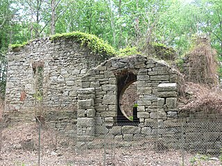
The restored South River Friends Meeting House, April 2024
The General Assembly recognized the settlement's growth by incorporating Lynchburg as a town in 1805; it was not incorporated as a city until 1852. In between, Lynch built Lynchburg's first bridge across the James River, a toll structure that replaced his ferry in 1812. A toll turnpike to Salem, Virginia was begun in 1817. Lynch died in 1820 and was buried beside his mother in the graveyard of the South River Friends Meetinghouse. Quakers later abandoned the town because of their opposition to slaveholding. Presbyterians took over the meetinghouse and adapted it as a church. It is now preserved as a historic site.
To avoid the many visitors at Monticello, Thomas Jefferson in 1806 developed a plantation and house near Lynchburg, called Poplar Forest. He often visited the town, noting, "Nothing would give me greater pleasure than to be useful to the town of Lynchburg. I consider it as the most interesting spot in the state." In 1810, Jefferson wrote, "Lynchburg is perhaps the most rising place in the U.S.... It ranks now next to Richmond in importance...."[8]
Early Lynchburg residents were not known for their religious enthusiasm. The established Church of England supposedly built a log church in 1765. In 1804, evangelist Lorenzo Dow wrote: "...where I spoke in the open air in what I conceived to be the seat of Satan's Kingdom. Lynchburg was a deadly place for the worship of God'." That referred to the lack of churches, which was corrected the following year. Itinerant MethodistFrancis Asbury visited the town; Methodists built its first church in 1805. Lynchburg hosted the last Virginia Methodist Conference that bishop Asbury attended (February 20, 1815).[9] As Lynchburg grew, prostitution and other "rowdy" activities became part of the urban mix of the river town. They were often ignored, if not accepted, particularly in a downtown area referred to as the "Buzzard's Roost."[citation needed] Methodist preacher and later bishop John Early became one of Lynchburg's civic leaders; unlike early Methodist preachers who had urged abolition of slavery during the Great Awakening; Early was of a later generation that had accommodated to this institution in the slave societies of the South.
On December 3, 1840, the James River and Kanawha Canal from Richmond reached Lynchburg. It was extended as far as Buchanan, Virginia in 1851, but never reached a tributary of the Ohio River as originally planned.[10] Lynchburg's population exceeded 6,000 by 1840, and a water works system was built. Floods in 1842 and 1847 wreaked havoc with the canal and towpath. Both were repaired. Town businessmen began to lobby for a railroad, but Virginia's General Assembly refused to fund such construction. In 1848 civic boosters began selling subscriptions for the Lynchburg and Tennessee Railroad.
By the 1850s, Lynchburg (along with New Bedford, Massachusetts) was among the richest towns per capita in the US.[11] Tobacco (including the manufacture of plug tobacco in factories using rented slave labor), slave-trading, general commerce, and iron and steel manufacturing powered the economy.[12][13]
During the American Civil War, Lynchburg served as a Confederate transportation hub and supply depot. It had 30 hospitals, often placed in churches, hotels, and private homes.
In June 1864, Union forces of General David Hunter approached within 1-mile (1.6km) as they drove south from the Shenandoah Valley. Confederate troops under General John McCausland harassed them. Meanwhile, the city's defenders hastily erected breastworks on Amherst Heights. Defenders were led by General John C. Breckinridge, who was an invalid from wounds received at the Battle of Cold Harbor. Union General Philip Sheridan appeared headed for Lynchburg on June 10, as he crossed the Chickahominy River and cut the Virginia Central Railroad. However, Confederate cavalry under General Wade Hampton, including the 2nd Virginia Cavalry from Lynchburg under General Thomas T. Munford, defeated his forces at the two-day Battle of Trevilian Station in Louisa County, and they withdrew. This permitted fast-marching troops under Confederate General Jubal Early to reach within four miles of Lynchburg on June 16 and tear up the tracks of the Orange and Alexandria Railroad to inhibit travel by Union reinforcements, while Confederate reinforcements straggled in from Charlottesville.
On June 18, 1864, in the Battle of Lynchburg, Early's combined forces, though outnumbered, repelled Union General Hunter's troops. Lynchburg's defenders had taken pains to create an impression that the Confederate forces within the city were much larger than they were in fact. For example, a train was continuously run up and down the tracks while drummers played and Lynchburg citizens cheered as if reinforcements were disembarking. Local prostitutes took part in the deception, misleading their Union clients about the large number of Confederate reinforcements. Narcissa Owen (Cherokee), wife of the president of the Lynchburg and Tennessee Railroad, later wrote about her similar deception of Union spies.[15]
From April 6 to 10, 1865, Lynchburg served as the capital of Virginia after the Confederate government fled from Richmond. Governor William Smith and the Commonwealth's executive and legislative branches escaped to Lynchburg as Richmond surrendered on April 3. Gen. Robert E. Lee surrendered to Gen. Ulysses S. Grant at Appomattox Courthouse, roughly 20-mile (32km) east of Lynchburg, ending the Civil War. Lynchburg surrendered on April 12, to Union General Ranald S. Mackenzie.[16]
Ten days later, Confederate Brigadier General James Dearing died. He was a native of nearby Campbell County and descendant of John Lynch; he had been wounded on April 6 at High Bridge during that Appomattox campaign. Mackenzie had visited his wounded friend and former West Point classmate, easing the transition of power.[16]
Post-Civil War recovery
The railroads that had driven Lynchburg's economy were destroyed by the war's end. The residents of the city deeply resented occupying forces under General John Irvin Gregg, and worked more readily with his affable successor General Newton Martin Curtis.[citation needed]Thomas J. Kirkpatrick became superintendent for the public education established under Virginia's Reconstruction-era legislature and Constitution of 1869, and built four new public schools. Previously, the only education for students from poor families was provided through St. Paul's Episcopal Church.
Floods in 1870 and 1877 destroyed the city's bridges (which were rebuilt) and the James River and Kanahwa Canal (which was not rebuilt). The towpath was used as the bed for laying the rails of the Richmond and Allegheny Railroad, a project conceived five decades earlier.
The city limits expanded in 1874. In 1881 that railroad was completed to Lynchburg, and another railroad reached it through the Shenandoah Valley. Lynchburg had a telegraph, about 15,000 residents, and the beginnings of a streetcar system. Many citizens, believing their city crowded enough, did not join the boosters who wanted Lynchburg to become the junction of that valley line and what became the Norfolk and Western Railroad, so the junction was moved to Big Lick. This later developed as the City of Roanoke.
Lynchburg, c. 1919
In the latter 19th century, Lynchburg embraced manufacturing (the city being sometimes referred to as the "Pittsburgh of the South").[citation needed] On a per capita basis, it became one of the wealthiest cities in the United States. In 1880, Lynchburg resident James Albert Bonsack invented the first cigarette-rolling machine. Shortly thereafter Dr. Charles Browne Fleet, a physician and pharmacological tinkerer, introduced the first micro-enema to be mass marketed over the counter. By the city's centennial in 1886, banking activity had increased sixfold over the 1860 level, which some attributed to slavery's demise. The Lynchburg Cotton Mill and Craddock-Terry Shoe Co. (which would become the largest shoe manufacturer in the South) were founded in 1888. The Reusens hydroelectric dam began operating in 1903 and soon delivered more power.[17]
In 1886, Virginia Baptists founded a training school, the Lynchburg Baptist Seminary. It began to offer a college-level program to African-American students in 1900. Now named the Virginia University of Lynchburg, it is the city's oldest institution of higher learning. Not far outside town, Randolph-Macon Woman's College and Sweet Briar College were founded as women's colleges in 1893 and 1901, respectively. In 1903, the Christian Church (Disciples of Christ) founded Lynchburg Christian College (later Lynchburg College) in what had been the Westover Hotel resort, which went bankrupt in the Panic of 1901. During the 2018–19 school year, the college's name was changed to the University of Lynchburg, reflecting its expansion of graduate-level programs and research. Lynchburg's first public library, Jones Memorial Library, opened in 1907.[17]
During World War I, the city's factories supported the war effort, and the area also supplied troops. The city powered through the Roaring Twenties and survived the Great Depression. Its first radio station, WLVA, began in 1930, and its airport opened in 1931. In 1938, the former fairgrounds were redeveloped as side-by-side baseball and football stadiums. [17]
Lynchburg lost its bid to gain access to an interstate highway. In the late 1950s, interested citizens, including Virginia Senator Mosby G. Perrow, Jr., asked the federal government to change its long-planned route for the interstate highway, now known as I-64, between Clifton Forge and Richmond.[18]
Since the 1940s, maps of the federal interstate highway system showed a proposed northern route, bypassing the manufacturing centers at Lynchburg and Roanoke. But federal officials assured Virginia that the state would decide the route.[19] Although initially favoring that northern route, Virginia's State Highway Commission eventually supported a southern route from Richmond via US-360 and US-460, which connected Lynchburg and Roanoke via US-220 from Roanoke to Clifton Forge, then continued west following US-60 into West Virginia.[20] However, in July 1961, Governor J. Lindsay Almond and US Secretary of Commerce Luther Hodges announced that the route would not be changed.[21] Lynchburg was left as the only city with a population in excess of 50,000 (at the time) that was not served by an interstate.[22]
The Virginia State Colony for Epileptics and Feebleminded (now known as the Central Virginia Training School), was established outside Lynchburg in Madison Heights. For several decades throughout the mid-20th century, the state of Virginia authorized compulsory sterilization of the mentally retarded for the purpose of eugenics. The operations were carried out at the institution. An estimated 8,300 Virginians were relocated to Lynchburg and sterilized there, making the city a "dumping ground" of sorts for the feeble-minded, poor, blind, epileptic, and those otherwise seen as genetically "unfit".[23]Carrie Buck challenged the state sterilization, but it was finally upheld by the United States Supreme Court in Buck v. Bell. She was classified as "feeble-minded" and sterilized while a patient at the Virginia State Colony.
Sterilizations were carried out for 35 years until 1972, when the operations were halted. Later in the late 1970s, the American Civil Liberties Union filed a class-action lawsuit against the state of Virginia on behalf of the sterilization victims. In the settlement, victims received formal apologies from the state and counseling if they chose, but the judiciary denied requests for the state to pay for reverse sterilization operations. In 1994, Buck's sterilization and litigation were featured as a television drama, Against Her Will: The Carrie Buck Story. The Manic Street Preachers address the issue in their song "Virginia State Epileptic Colony" on their 2009 album Journal for Plague Lovers.
Modern revitalization
Liberty University, founded in 1971 as Lynchburg Baptist College and renamed in 1985, is one of the country's largest institutions of higher education and the largest employer in the Lynchburg region. The university states that it generates over $1 billion in economic impact to the Lynchburg area annually.[24][25][26]
Lynchburg has ten recognized historic districts, four of them in the downtown residential area.[27][28] Since 1971, 40 buildings have been individually listed on the National Register of Historic Places.[29]
Downtown Lynchburg has undergone significant revitalization, with hundreds of new loft apartments created through adaptive reuse of historic warehouses and mills. Since 2000, downtown has attracted private investments of more than $110million, and business activity increased by 205% from 2004 to 2014.[30] In 2014, 75 new apartment units were added to downtown Lynchburg, with 155 further units under construction, increasing the number of housing units downtown by 48% from 2010 to 2014.[30]
In 2015, the $5.8-million Lower Bluffwalk pedestrian street zone opened.[31] Notable projects underway in downtown by the end of 2015 include the $25-million Virginian Hotel restoration project, a $16.6-million restoration of the Academy Center of the Arts, and $4.6-million expansion of Amazement Square Children's Museum.[32][33][34][35]
2017 – President Donald Trump gives commencement speech at Liberty University.[46]
2023 - Stephanie Reed becomes mayor.
Geography
According to the United States Census Bureau, the city has a total area of 49.6 square miles (128.5km2), of which 49.2 square miles (127.4km2) is land and 0.5 square miles (1.3km2) (1.0%) is water.[51]
Neighborhoods
The first neighborhoods of Lynchburg developed upon seven hills adjacent to the original ferry landing.[52] These neighborhoods include:
Other major neighborhoods, with more upside, include Tinbridge Hill, Boonsboro, Trents Ferry, Rivermont, Fairview Heights (Campbell Ave corridor), Jackson Heights, Federal Hill (Federal Street, Jackson Street, Harrison Street) Fort Hill, Forest Hill (Old Forest Rd. Area), Timberlake, Windsor Hills, Sandusky, Sheffield, Linkhorne, Cornerstone and Wyndhurst.
Climate
Lynchburg has a four-season humid subtropical climate (KöppenCfa), with cool winters and hot, humid summers. The monthly daily average temperature ranges from 35.9°F (2.2°C) in January to 76.0°F (24.4°C) in July.[53] Nights tend to be significantly cooler than days throughout much of the year due in part to the moderate elevation. In a typical year, there are 27.4 days with a high temperature 90°F (32°C) or above, and 6.2 days with a high of 32°F (0°C) or below.[53][54] Snowfall averages 11.6 inches (29cm) per season but this amount varies highly with each winter; the snowiest winter is 1995–96 with 56.8in (144cm) of snow, but the following winter recorded only trace amounts, the least on record.[55] The average snowiest month is February which corresponds with the annual peak in nor'easter activity. The plant hardiness zone is 7b with an average annual extreme minimum air temperature of 5°F (−15°C).
Temperature extremes range from 106°F (41°C), recorded on July 10, 1936, down to −11°F (−24°C), recorded on February 20, 2015.[53] However, several decades may pass between 100 and 0°F (38 and −18°C) readings, with the last such occurrences being July 8, 2012 and February 20, 2015, respectively.[53]
One of the most prominent nicknames of Lynchburg is the "City of Seven Hills." This is due to one prominent feature of its geography, the seven hills that are spread throughout the region. The seven hills are: College Hill, Garland Hill, Daniel's Hill, Federal Hill, Diamond Hill, White Rock Hill, and Franklin Hill.[57]
Note: the U.S. Census treats Hispanic/Latino as an ethnic category. This table excludes Latinos from the racial categories and assigns them to a separate category. Hispanics/Latinos can be of any race.
2010 census
As of the 2010 census,[64] there were 75,568 people, 25,477 households, and 31,992 families residing in the city. The population density was 1,321.5 peopleper square mile (510.2 people/km2). There were 27,640 housing units at an average density of 559.6 unitsper square mile (216.1 units/km2). The racial makeup of the city was 63.0% White, 29.3% African American, 0.2% Native American, 2.5% Asian, 0.04% Pacific Islander, 0.63% from other races, and 1.7% from two or more races. Hispanic or Latino of any race were 3.0% of the population.
There were 25,477 households, out of which 27.8% had children under the age of 18 living with them, 41.6% were married couples living together, 16.0% had a female householder with no husband present, and 38.8% were non-families. 32.7% of all households were made up of individuals, and 12.9% had someone living alone who was 65 years of age or older. The average household size was 2.30 and the average family size was 2.92.
The age distribution of the city had: 22.1% under the age of 18, 15.5% from 18 to 24, 25.3% from 25 to 44, 20.8% from 45 to 64, and 16.3% who were 65 years of age or older. The median age was 35 years. For every 100 females, there were 84.2 males. For every 100 females aged 18 and over, there were 79.1 males.
The median income for a household in the city was $32,234, and the median income for a family was $40,844. Males had a median income of $31,390 versus $22,431 for females. The per capita income for the city was $18,263. About 12.3% of families and 15.9% of the population were below the poverty line, including 22.4% of those under age 18 and 10.7% of those age 65 or over.
Lynchburg ranks below the 2006 median annual household income for the U.S. as a whole, which was $48,200, according to the US Census Bureau.[65]
In 2009, almost 27% of Lynchburg children lived in poverty. The state average that year was 14%.[66]
Economy
Bank of the James in LynchburgAllied Arts Building in Downtown Lynchburg, completed in 1931
Of Virginia's larger metro areas, Forbes Magazine ranked Lynchburg the 5th best place in Virginia for business in 2006, with Virginia being the best state in the country for business.[67] In the same survey, Lynchburg achieved the rank of 109th in the nation.
Industries within the Lynchburg MSA include nuclear technology, pharmaceuticals, and material handling. A diversity of small businesses with the region has helped maintain a stable economy and has minimized the impacts of nation-wide economic downturns.[68][69]
Arts and culture
In a Forbes magazine survey, Lynchburg ranked 189 for cultural and leisure out of 200 cities surveyed:[70]
Lynchburg Symphony Orchestra. Created in 1983, throughout the years a variety of music has been presented, from the classical to the patriotic to the popular.[71]
Academy of Fine Arts. Greater Lynchburg's center for arts, culture, and community building.[72]
Renaissance Theater. The longest-running community theater in the area, open for over 25 years.
Lynchburg Art Club. Formed in March 1895.
Opera on the James. Opera performed by national and regional artists in a wide variety of venues since 2005 including classic grand operas, small scale lesser-known operas, contemporary works, family operas, concerts of diverse repertoire, lectures, school tours and free community outreach.
The Maier Museum of Art. The museum is located on the campus of Randolph College and features works by American artists of the 19th and 20th centuries.
Riverviews Artspace. A nonprofit arts organization presenting contemporary art exhibitions, multi-disciplinary programs, and events.
Wolfbane Productions. An award-winning performing arts organization with year-round performances and cultural events.
Crabtree Falls: The longest waterfall east of the Mississippi River, is located in Nelson County, Virginia. The trail leads hikers along a 1.7-mile hike with views of five cascades of Crabtree Falls. The land formerly in private ownership prior to the late 1970s is in the George Washington National Forest. Crabtree Falls sits near two undeveloped mountainous areas designated as Wilderness areas: The Priest & Three Ridges respectfully. Since 1982, thirty (30) people have fallen to their deaths due to navigating too far away from the trail. There are warning signs at the public trailhead because of this.
James River Heritage Trail: Composed of two smaller trails, the Blackwater Creek Bikeway and RiverWalk.[74]
Trails of Blackwater Creek: a network of paved and unpaved trails weaving through the Blackwater Creek natural area.[75][76]
Miller-Claytor House: Pre-19th century townhouse where Thomas Jefferson allegedly proved to the owner of the house's garden that tomatoes were not poisonous by eating one of the fruit.[77] Home was dismantled in 1936 and rebuilt at its Riverside Park location, where the garden was also restored.
National D-Day Memorial: Located in Bedford, Virginia, it commemorates all those who served the United States during the D-Day Invasion of Normandy, France on June 6, 1944, during World War II.
Nature Zone: A division of Lynchburg Parks and Recreation.
Old City Cemetery Museums & Arboretum: The most visited historic site in the City of Lynchburg. Established in 1806, the Old City Cemetery is Lynchburg's only publicly owned burial ground and one of its oldest cemeteries.[78] It is also home to the largest public collection of heirloom or "antique" roses in the Commonwealth of Virginia.[79]
The Old Court House: This Hill City landmark was built in 1855. Fashioned as a Greek temple high above the James River, it is now the home of Central Virginia's best collection of memorabilia, furnishings, costumes and industrial history.[citation needed]
Poplar Forest: Thomas Jefferson's retreat home. Jefferson designed the octagonal house during his second term as president and sojourned here in his retirement to find rest and leisure and escape public life. Ongoing restoration and archaeology is taking place at the site.[needs update] A future access road/parkway is planned between the property and the Wyndhurst community with an existing signalized intersection on Enterprise Drive.[needs update]
Lynchburg City Stadium – Calvin Falwell Field Lynchburg HillcatsHollins Mill Waterfall on the Blackwater Creek Greenway, James River Heritage Trail
Lynchburg is home to sporting events and organizations including:
Blackwater Rugby Club: a local Men's Division III rugby club, part of the Capitol Rugby Union of USA Rugby.
7 Hills Hash House Harriers: The local chapter of an international group of non-competitive running, social and drinking clubs.
Hiking areas include the Appalachian Trail, Peaks of Otter, Apple Orchard Falls Trail, Blackwater Creek Natural Area, Liberty Mountain Trail System, Crabtree Falls, Holliday Lake, Mount Pleasant National Scenic Holliday Lake, and Otter Creek Trail.
Liberty Mountain SnowFlex Centre: A synthetic ski slope featuring Snowflex, located near Liberty University. It includes beginner, intermediate and advanced slopes for year-round skiing, snowboarding, and inner-tubing. It is the first of its kind in the United States.[85][86]
Government
Lynchburg City Hall
Lynchburg uses a council-manager system. The Lynchburg City Council is composed of seven members that each serve a four-year term. There are four wards that elect a member; the remaining three are elected in at-large elections in which the top three candidates obtain a seat. The City Council is also responsible for appointing a city manager, city attorney, and city clerk.
Lynchburg has traditionally been a conservative stronghold. This predates the influence of Liberty University; it was one of the first areas of the state where the old-line Byrd Democrats began splitting their tickets at the national level. However, conservative Democrats continued to hold most local offices well into the 1970s.
However, the Democratic Party has seen a gradual increase in popularity in the city since the 1990s, and Lynchburg's political atmosphere has become increasingly moderate. In the 2020 United States presidential election, a plurality of voters in Lynchburg voted for Democratic challenger Joe Biden over Republican incumbent Donald Trump.[104] Biden was the first Democrat to carry Lynchburg since Harry S. Truman in 1948.
The city is also home to a number of religious and non-religious private schools, including Appomattox Christian Academy, Desmond T Doss Christian Academy, James River Day School, Liberty Christian Academy, New Covenant Classical Christian School, Timberlake Christian Academy , Virginia Episcopal School, and New Vistas School.
The GLTC selected a property directly across from Lynchburg-Kemper Street Station as its top choice of sites upon which to build the new transfer center for their network of public buses. They were interested in facilitating intermodal connections between GLTC buses and the intercity bus and rail services which operate from that location. The project was completed and opened to the public on June 16, 2014.[123][124]
On August 23, 2017, the GLTC launched The Hopper, a free downtown circulator bus with a $479,348 grant from the Virginia Smart Scale program.[125][126] On June 29, 2019, the GLTC ended service for The Hopper due to "consistently low ridership" and the expiration of a $117,820 state grant that covered operating costs.[127]
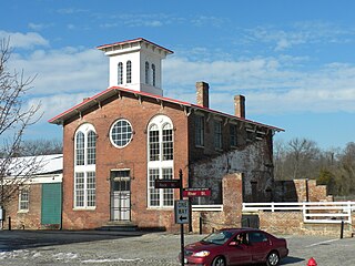
Intercity passenger rail and bus services are based out of Kemper Street Station, a historic, three-story train station recently restored and converted by the city of Lynchburg to serve as an intermodal hub for the community. The station is located at 825 Kemper Street.[128]
Bus
Greyhound Lines located their bus terminal in the main floor of Kemper Street Station following its 2002 restoration.[128] Greyhound offers transport to other cities throughout Virginia, the U.S., Canada, and Mexico.
In October 2009, Lynchburg became the southern terminus for a Northeast Regional that previously had overnighted in Washington. The forecast ridership was 51,000 for the 180-mile extension's first year, but the actual count was triple that estimate, and the train paid for itself without any subsidy.[129] By FY 2015, the Regional had 190,000 riders. The Lynchburg station alone served a total of 85,000 riders in 2015. It is located in the track level ground floor of Kemper Street Station.[130]
Lynchburg has two major freight railroads. It is the crossroads of two Norfolk Southern lines. One is the former mainline of the Southern Railway, upon which Kemper Street Station is situated. NS has a classification yard located next to the shopping mall. Various yard jobs can be seen. Railfans who wish to visit the NS Lynchburg yard are advised to inquire with an NS official. CSX Transportation also has a line through the city and a small yard.
Air
Lynchburg Regional Airport is solely served by American Eagle to Charlotte, North Carolina. American Eagle, a subsidiary of American Airlines, is the only current scheduled airline service provider, with seven daily arrivals and departures to Charlotte Douglas International Airport. In recent years air travel has increased, with 157,517 passengers flying in and out of the airport in 2012, representing 78% of the total aircraft load factor for that time period.
Highway
Primary roadways include U.S. Route 29, U.S. Route 501, U.S. Route 221, running north–south, and U.S. Highway 460 (Richmond Highway), running east–west. While Lynchburg is the largest city in Virginia not served by an interstate, parts of Route 29 have been upgraded to interstate standards and significant improvements have been made to Highway 460 in the immediate vicinity to Lynchburg and suburban areas.
↑ Mean monthly maxima and minima (i.e. the expected highest and lowest temperature readings at any point during the year or given month) calculated based on data at said location from 1991 to 2020.
↑ Official records for Lynchburg were kept at the Weather Bureau Office from January 1893 to July 1944, and at Lynchburg Regional since August 1944. For more information, see ThreadEx
Related Research Articles
Richmond is the capital city of the Commonwealth of Virginia in the United States. Incorporated in 1742, Richmond has been an independent city since 1871. The city's population in the 2020 census was 226,610, up from 204,214 in 2010, making it Virginia's fourth-most populous city. The Richmond metropolitan area, with over 1.3 million residents, is the Commonwealth's third-most populous.
Roanoke is an independent city in the U.S. state of Virginia. It is located in Southwest Virginia along the Roanoke River, in the Blue Ridge range of the greater Appalachian Mountains. Roanoke is approximately 50 miles (80 km) north of the Virginia–North Carolina border and 250 miles (400 km) southwest of Washington, D.C., along Interstate 81. At the 2020 census, Roanoke's population was 100,011, making it the most-populous city in Virginia west of the state capital Richmond. It is the primary population center of the Roanoke metropolitan area, which had a population of 315,251 in 2020.
Radford is an independent city in the U.S. state of Virginia. As of 2020, the population was 16,070 by the United States Census Bureau. For statistical purposes, the Bureau of Economic Analysis combines the city of Radford with neighboring Montgomery County.
Petersburg is an independent city in the Commonwealth of Virginia in the United States. As of the 2020 census, the population was 33,458 with a majority black American. The Bureau of Economic Analysis combines Petersburg with Dinwiddie County for statistical purposes. The city is 21 miles (34 km) south of the commonwealth (state) capital city of Richmond.
Danville is an independent city in the Commonwealth of Virginia in the United States. The city is located in the Southside Virginia region and on the fall line of the Dan River. It was a center of tobacco production and was an area of Confederate activity during the American Civil War, due to its strategic location on the Richmond and Danville Railroad. In April 1865 it briefly served as the third and final capital of the Confederacy before its surrender later that year.
Buena Vista is an independent city located in the Blue Ridge Mountains region of Virginia in the United States. As of the 2020 census, the population was 6,641. The Bureau of Economic Analysis combines the independent cities of Buena Vista and Lexington, along with surrounding Rockbridge County, for statistical purposes.
Bedford County is a United States county located in the Piedmont region of the Commonwealth of Virginia. Its county seat is the town of Bedford, which was an independent city from 1968 until rejoining the county in 2013.
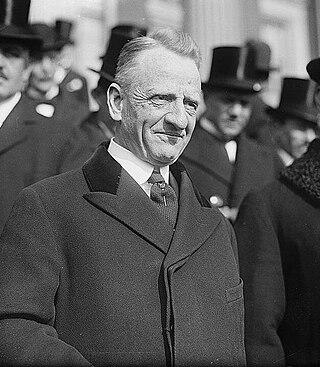
Carter Glass was an American newspaper publisher and Democratic politician from Lynchburg, Virginia. He represented Virginia in both houses of Congress and served as the United States Secretary of the Treasury under President Woodrow Wilson. He played a major role in the establishment of the U.S. financial regulatory system, helping to establish the Federal Reserve System and the Federal Deposit Insurance Corporation.
Midlothian is an unincorporated area and Census-designated place in Chesterfield County, Virginia, U.S. Settled as a coal town, Midlothian village experienced suburbanization effects and is now part of the western suburbs of Richmond, Virginia south of the James River in the Greater Richmond Region. Because of its unincorporated status, Midlothian has no formal government, and the name is used to represent the original small Village of Midlothian and a vast expanse of Chesterfield County in the northwest portion of Southside Richmond served by the Midlothian post office.
The Southside Railroad was formed in Virginia in 1846. Construction was begun in 1849 and completed in 1854. The 5 ft gauge railroad connected City Point, a port on the James River with the farm country south and west of Petersburg, Virginia, to Lynchburg, Virginia, a distance of about 132 miles (212 km).
The James River and Kanawha Canal was a partially built canal in Virginia intended to facilitate shipments of passengers and freight by water between the western counties of Virginia and the coast. Ultimately its towpath became the roadbed for a rail line following the same course.
The Virginia and Tennessee Railroad was an historic 5 ft gauge railroad in the Southern United States, much of which is incorporated into the modern Norfolk Southern Railway. It played a strategic role in supplying the Confederacy during the American Civil War.
The Tri-Cities of Virginia is an area in the Greater Richmond Region which includes the three independent cities of Petersburg, Colonial Heights, and Hopewell and portions of the adjoining counties of Chesterfield, Dinwiddie, and Prince George in south-central Virginia. Other unincorporated communities located in the Tri-Cities area include Ettrick, Fort Gregg-Adams, and City Point, the latter formerly a historic incorporated town which was annexed to become part of the City of Hopewell.
Carrsville is a census-designated place (CDP) in Isle of Wight County in the Hampton Roads region of southeastern Virginia in the United States. The population as of the 2010 Census was 359. The town is named for Jesse Carr, whose family had long roots in Isle of Wight County. Jesse Carr died in the place that would later bear his name.
U.S. Route 460 (US 460) in Virginia runs west-east through the southern part of the Commonwealth. The road has two separate pieces in Virginia, joined by a relatively short section in West Virginia. Most of US 460 is a four-lane divided highway and is a major artery in the southern third of the state. From Petersburg to Suffolk, US 460 is a four-lane non-divided highway. It is a popular alternative to Interstate 64 (I-64) when going from Richmond and other points in central Virginia to the Currituck Sound and Outer Banks of North Carolina, avoiding the congestion and tunnels of the more northerly I-64 corridor. The road passes through several small towns that built up at stops along the railroad line.
The Roanoke Region is the area of the Commonwealth of Virginia surrounding the city of Roanoke. Its usage may refer to the metropolitan statistical area or the Roanoke Valley, but it sometimes includes areas in the Allegheny Mountains and New River Valley which includes Alleghany County, Montgomery County, Covington, Clifton Forge, Blacksburg, Christiansburg, and Radford. Bedford County and Floyd County are sometimes included as part of the region.
Samuel Daniel McDearmon (1815–1871), also known as Samuel D. McDearmon, was a Confederate army officer during the American Civil War. He held a number of political and government offices, and played a significant role in the development of Appomattox and Appomattox Court House, Virginia.
Concord is a census-designated place (CDP) in Appomattox and Campbell counties in the U.S. state of Virginia. The population as of the 2010 census was 1,458.
1 2 "Station: Lynchburg RGNL AP, VA". U.S. Climate Normals 2020: U.S. Monthly Climate Normals (1991-2020). National Oceanic and Atmospheric Administration. Retrieved July 2, 2021.
↑ Hines, Emilee. More Than Petticoats: Remarkable Virginia Women. Globe Pequot Press, 2003: 128. ISBN0-7627-2364-5
Bibliography
Richard Edwards, ed. (1855), "Lynchburg", Statistical Gazetteer of the State of Virginia, Richmond{{citation}}: CS1 maint: location missing publisher (link)
George E. Waring, Jr.; U.S. Department of the Interior, Census Office (1887), "Virginia: Lynchburg", Report on the Social Statistics of Cities: Southern and the Western States, Washington, DC: Government Printing Office, pp.60–64
Blackford, Charles M. Jr. (1891). Annals of the Lynchburg Home Guard. Lynchburg, Va.: Lynchburg Home Guard – via John W. Rohr, Electric Power Printer and Binder.
"Lynchburg", Rand, McNally & Co.'s Handy Guide to the Southeastern States, Chicago: Rand, McNally & Co., 1899 – via Internet Archive
Houck, Peter W. (1986). A Prototype of a Confederate Hospital Center in Lynchburg, Virginia. Lynchburg, Va.: Warwick House Pub. LCCN86-50952. OCLC15334361.
Steven Elliot Tripp (1993). "Race, Class, and Religion: Lynchburg, Virginia's 'Great Revival of 1871'". Mid-America. 75. Loyola University Chicago. ISSN0026-2927.
This page is based on this Wikipedia article Text is available under the CC BY-SA 4.0 license; additional terms may apply. Images, videos and audio are available under their respective licenses.