Related Research Articles

Winchester is the northwesternmost independent city in the Commonwealth of Virginia, United States. It is the county seat of Frederick County, although the two are separate jurisdictions. As of the 2020 census, the city's population was 28,120. It is the principal city of the Winchester metropolitan area extending into West Virginia, which is a part of the Washington–Baltimore combined statistical area. Winchester is home to Shenandoah University and the Museum of the Shenandoah Valley.

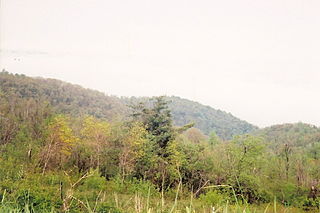
The Shenandoah Valley is a geographic valley and cultural region of western Virginia and the Eastern Panhandle of West Virginia in the United States. The Valley is bounded to the east by the Blue Ridge Mountains, to the west by the eastern front of the Ridge-and-Valley Appalachians, to the north by the Potomac River, to the south by the James River, and to the Southwest by the New River Valley. The cultural region covers a larger area that includes all of the Valley plus the Virginia Highlands to the west and the Roanoke Valley to the south. It is physiographically located within the Ridge and Valley Province and is a portion of the Great Appalachian Valley.

The Great Appalachian Valley, also called The Great Valley or Great Valley Region, is one of the major landform features of eastern North America. It is a gigantic trough, including a chain of valley lowlands, and the central feature of the Appalachian Mountains system. The trough stretches about 1,200 miles (1,900 km) from Quebec in the north to Alabama in the south and has been an important north–south route of travel since prehistoric times.

The Blue Ridge Mountains are a physiographic province of the larger Appalachian Highlands range. The mountain range is located in the Eastern United States and extends 550 miles southwest from southern Pennsylvania through Maryland, West Virginia, Virginia, North Carolina, South Carolina, Tennessee, and Georgia. The province consists of northern and southern physiographic regions, which divide near the Roanoke River gap. To the west of the Blue Ridge, between it and the bulk of the Appalachians, lies the Great Appalachian Valley, bordered on the west by the Ridge and Valley province of the Appalachian range.

The Allegheny Mountain Range, informally the Alleghenies, is part of the vast Appalachian Mountain Range of the Eastern United States and Canada and posed a significant barrier to land travel in less developed eras. The Allegheny Mountains have a northeast–southwest orientation, running for about 300 miles (480 km) from north-central Pennsylvania, southward through western Maryland and eastern West Virginia.
The Battle of Manassas Gap, also known as the Battle of Wapping Heights, took place on July 23, 1863, in Warren County, Virginia, at the conclusion of General Robert E. Lee's retreat back to Virginia in the final days of the Gettysburg Campaign of the American Civil War. Union forces attempted to force passage across the Blue Ridge Mountains and attack the Confederate rear as it formed a defensive position in the upper Shenandoah Valley. Despite successfully forcing the passage at Manassas Gap, the Union force was unable to do so before Lee retreated further up the valley to safety, resulting in an inconclusive battle.
John Savage was an 18th-century surveyor of colonial Virginia. He surveyed as part of a 1736 expedition to settle a boundary dispute between Lord Fairfax and the English Privy Council concerning the extent of the vast Northern Neck land grant.
The Monacan Indian Nation is one of eleven Native American tribes recognized since the late 20th century by the U.S. Commonwealth of Virginia. In January 2018, the United States Congress passed an act to provide federal recognition as tribes to the Monacan and five other tribes in Virginia. They had earlier been so disrupted by land loss, warfare, intermarriage, and discrimination that the main society believed they no longer were "Indians". However, the Monacans reorganized and asserted their culture.

The Knights of the Golden Horseshoe Expedition, also known as the Transmontane Expedition, took place in 1716 in the British Colony of Virginia. The Royal Governor and a number of prominent citizens traveled westward, across the Blue Ridge Mountains on an exploratory expedition. It is a frequently recounted event of the History of Virginia.
Thornton Gap is a wind gap located in the Blue Ridge Mountains in Virginia separating the Shenandoah Valley from the Piedmont region of the state.

The Manahoac, also recorded as Mahock, were a small group of Siouan-language Native Americans in northern Virginia at the time of European contact. They numbered approximately 1,000 and lived primarily along the Rappahannock River west of modern Fredericksburg and the Fall Line, and east of the Blue Ridge Mountains. They united with the Monacan, the Occaneechi, the Saponi and the Tutelo. They disappeared from the historical record after 1728.

The Native American tribes in Virginia are the Indigenous peoples whose tribal nations historically or currently are based in the Commonwealth of Virginia in the United States of America.

The Great Indian Warpath (GIW)—also known as the Great Indian War and Trading Path, or the Seneca Trail—was that part of the network of trails in eastern North America developed and used by Native Americans which ran through the Great Appalachian Valley. The system of footpaths extended from what is now upper New York to deep within Alabama. Various Native peoples traded and made war along the trails, including the Catawba, numerous Algonquian tribes, the Cherokee, and the Iroquois Confederacy. The British traders' name for the route was derived from combining its name among the northeastern Algonquian tribes, Mishimayagat or "Great Trail", with that of the Shawnee and Delaware, Athawominee or "Path where they go armed".

Linden is a small unincorporated village in Fauquier and Warren Counties in the U.S. state of Virginia. It is located west of Washington, D.C. at exit 13 off of Interstate 66.
The Eno or Enoke, also called Stuckenock, was an American Indian tribe located in North Carolina during the 17th and 18th centuries that was later absorbed into the Catawba tribe in South Carolina along with various other smaller tribal bands.

The Doeg were a Native American people who lived in Virginia. They spoke an Algonquian language and may have been a branch of the Nanticoke tribe, historically based on the Eastern Shore of Maryland. The Nanticoke considered the Algonquian Lenape as "grandfathers". The Doeg are known for a raid in July 1675 that contributed to colonists' uprising in Bacon's Rebellion.
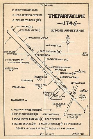
The Fairfax Line was a surveyor's line run in 1746 to establish the limits of the "Northern Neck land grant" in colonial Virginia.
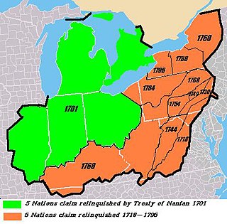
The Six Nations land cessions were a series of land cessions by the Haudenosaunee and Lenape which ceded large amounts of land, including both recently conquered territories acquired from other indigenous peoples in the Beaver Wars, and ancestral lands to the Thirteen Colonies and the United States. The land ceded covered, partially or in the entire, the U.S. states of New York, Pennsylvania, Maryland, Virginia, West Virginia, Kentucky, Ohio, Tennessee and North Carolina. They were bordered to the west by the Algonquian lands in the Ohio Country, Cherokee lands to the south, and Muscogee and Choctaw lands to the southeast.

The protohistoric period of the state of West Virginia in the United States began in the mid-sixteenth century with the arrival of European trade goods. Explorers and colonists brought these goods to the eastern and southern coasts of North America and were brought inland by native trade routes. This was a period characterized by increased intertribal strife, rapid population decline, the abandonment of traditional life styles, and the extinction and migrations of many Native American groups.
The Trader's Path was a colonial highway through southwestern Virginia, established in 1740.
References
- ↑ Lewis, J.D. "Dr. John Lederer". carolana.com. Retrieved 11 November 2015.
- 1 2 3 Cunz, Dieter (1942), "John Lederer: Significance and Evaluation", William and Mary Quarterly , accessed 3 April 2010
- ↑ "John Lederer". The West Virginia Encyclopedia. Retrieved 11 November 2015.
- ↑ Minichiello, J. Kent; Anthony W. White (2000) "The First Expedition to the Blue Ridge Mountains" (page 51-54) in From Blue Ridge to Barrier Islands: An Audubon Naturalist Reader (JHU Press) ISBN 9780801865312
- ↑ Lederer, John. "The discoveries of John Lederer, in three several marches from Virginia, to the west of Carolina, and other parts of the continent: begun in March 1669, and ended in September 1670". Rochester, N.Y., Reprinted for G. P. Humphrey, 1902. Retrieved 11 November 2015.
- ↑ Cumming, W. P. "Lederer, Johann (or John)". Dictionary of North Carolina Biography, University of North Carolina Press. Retrieved 11 November 2015.