Mechanicsville is an unincorporated area and census-designated place (CDP) in Hanover County, Virginia, United States. The population was 39,482 during the 2020 census, up from 36,348 at the 2010 census.

Bassett is a census-designated place (CDP) in Henry County, Virginia, United States. The population was 1,100 at the 2010 census. It is part of the Martinsville Micropolitan Statistical Area. The town was founded along a rail line by the same family that later started Bassett Furniture. Bassett Furniture's headquarters have remained in Bassett since it began in 1902.

Falmouth is a census-designated place (CDP) in Stafford County, Virginia, United States. Situated on the north bank of the Rappahannock River at the falls, the community is north of and opposite the city of Fredericksburg. Recognized by the U.S. Census Bureau as a census-designated place (CDP), Falmouth's population was 4,274 as of the 2010 census.

Brandy Station is an unincorporated community and census-designated place (CDP) in Culpeper County, Virginia, United States. It was first listed as a CDP in the 2020 census with a population of 191. Its original name was Brandy. The name Brandy Station comes from a local tavern sign that advertised brandy.

Catlett is a census-designated place (CDP) in Fauquier County, Virginia, United States. The population as of the 2010 census was 297. It is located west of the Prince William County line. Catlett was formerly a rail stop on the Orange and Alexandria Railroad, and the area was the site of many raids on the railroad during the American Civil War.

Elliston is a census-designated place (CDP) in Montgomery County, Virginia, United States. It lies between the city of Roanoke and the town of Christiansburg in the southwestern part of the state. The population as of the 2010 Census was 902. It is home to a small fire department, an elementary school, two gas stations, a train stop, and several churches. Most of its residents commute to larger towns. A set of railroad tracks separates the northwestern part of the town from the rest. US highway 11-460 further divides the town into two distinct neighborhoods, "Oldtown," which formed along the Valley Road in the 1850s, and "The Brake," a predominantly African-American area that developed after the Civil War.

Buckingham is a census-designated place in and the county seat of Buckingham County, Virginia, United States. The population as of the 2010 Census was 133.
Heathsville is a census-designated place (CDP) in and the county seat of Northumberland County, Virginia, United States. Heathsville is in the easternmost county of the Northern Neck of Virginia, which was the birthplace of three of the first five Presidents of the United States - George Washington, James Madison, and James Monroe. It is the county seat of Northumberland County, and has housed four county courthouses since the first was built in 1663.

Aldie is an unincorporated community and census-designated place (CDP) located between Chantilly and Middleburg in Loudoun County, Virginia, United States. The historic village of Aldie is located on the John Mosby Highway in a gap between the Catoctin Mountains and Bull Run Mountains, through which the Little River flows. Aldie traditionally serves as the gateway to the Loudoun Valley and beyond.

Cass is a census-designated place (CDP) and unincorporated community on the Greenbrier River in Pocahontas County, West Virginia, United States. The population was 38 at the 2020 census. The community, founded in 1901, was named for Joseph Kerr Cass, vice president and cofounder of the West Virginia Pulp and Paper Company.
Clover is an unincorporated community and census-designated place (CDP) in rural Halifax County, Virginia, United States. The population as of the 2010 census was 438. Clover was an incorporated town from 1895 until 1998, when it reverted to unincorporated status. Clover was the site of a Rosenwald school, built around 1921 or 1922, with a three-teacher facility on a 2-acre campus.
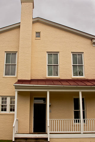
Dinwiddie County Court House is a historic courthouse building located at the junction of U.S. 1 and VA 619 in Dinwiddie, Dinwiddie County, Virginia. It was built in 1851, and is a two-story, brick temple-form building in the Greek Revival style. It measures approximately 37 feet (11 m) wide and 78 feet (24 m) long, and features a front portico added in 1933. The courthouse was the site of the Battle of Dinwiddie Court House in the closing stages of the American Civil War. The Dinwiddie County Historical Society is currently located in this building.

King William is a census-designated place (CDP) in and the county seat of King William County, Virginia, United States. The population as of the 2010 census was 252. Located in King William is the oldest courthouse in continuous use in the United States, built in 1725. The community is also known as King William Courthouse or, by an alternative spelling, King William Court House.

Lancaster is an unincorporated community and census-designated place (CDP) in Lancaster County, Virginia, United States. It is the county seat, and is also known as Lancaster Courthouse or by an alternative spelling, Lancaster Court House. The community was first drawn as a CDP prior to the 2020 census.

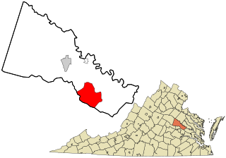
Nottoway, or Nottoway Court House, is a census-designated place (CDP) in and the county seat of Nottoway County, Virginia, United States. The population as of the 2010 Census was 84.

New Baltimore is an unincorporated community and census-designated place (CDP) in eastern Fauquier County, Virginia, United States. The population as of the 2010 census was 8,119. The community has existed since the early 19th century, but it has had its most significant growth since the 1980s. It is the portion of Fauquier County with the easiest access to Washington, D.C., and as a result, many people who live in New Baltimore commute into DC. Other major communities close to New Baltimore are Warrenton, Gainesville/Haymarket area, and Manassas. The area officially considered to be New Baltimore expanded significantly in 2006 with Fauquier County's designation of service districts, of which New Baltimore is one. The service district designation provides added access to utilities such as water and sewer, and targets the area for growth.
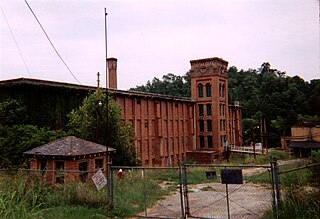
Newry is a census-designated place in Oconee County, South Carolina, United States. According to the 2010 United States Census, the population of the CDP was 172.

This is a list of the National Register of Historic Places listings in Dinwiddie County, Virginia.

Deerfield is a census-designated place (CDP) in Augusta County, Virginia, United States. The population as of the 2010 Census was 132. It has a very low population density, as it is a small unincorporated rural area. The Deerfield mall is the main store of the town. Deerfield consists of farms, hunting areas, old plantation houses, and scenic views of the mountains. Deer, bear, and other forms of wildlife fill the area. Deerfield has its own post office, fire department, rescue squad, dump, and a historic school house. Students who live in Deerfield attend Churchville Elementary School, Beverley Manor Middle School, and Buffalo Gap High School.
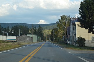
Bartow is a census-designated place (CDP) in Pocahontas County, West Virginia, United States. The population was 111 at the 2010 census.


