
Gap is a census-designated place (CDP) and unincorporated community in Salisbury Township, Lancaster County, Pennsylvania, United States, with a ZIP code of 17527. The population was 1,931 at the 2010 census. U.S. Route 30 passes through the town, which is also the terminus for four Pennsylvania highways: 772, 741, 897, and the heavily used 41, which leads toward Wilmington, Delaware.

Maytown is an unincorporated community and census-designated place (CDP) in Lancaster County, Pennsylvania, United States. The population was 4,098 at the 2020 census.

Hockessin is a census-designated place (CDP) in New Castle County, Delaware, United States. The population was 13,478 at the 2020 Census.
Schaefferstown is an unincorporated community and census-designated place (CDP) in Heidelberg Township, Lebanon County, Pennsylvania, United States. The population was 941 at the 2010 census.

Chesterfield is an unincorporated community that is the county seat of Chesterfield County, Virginia, United States. It was a census-designated place (CDP) at the 2020 census. It was not delineated as a CDP for the 2010 census. The Chesterfield County Courthouse and Courthouse Square are listed in the National Register of Historic Places. The area is also home of the Chesterfield County Government Complex.

Falmouth is a census-designated place (CDP) in Stafford County, Virginia, United States. Situated on the north bank of the Rappahannock River at the falls, the community is north of and opposite the city of Fredericksburg. Recognized by the U.S. Census Bureau as a census-designated place (CDP), Falmouth's population was 4,274 as of the 2010 census.

Dinwiddie is an unincorporated community, census-designated place (CDP), and the county seat of Dinwiddie County, Virginia, United States. It was first listed as a CDP in the 2020 census with a population of 619.

Marshall is a census-designated place (CDP) and unincorporated town in northwestern Fauquier County, Virginia, in the United States. The population as of the 2010 census was 1,480.
Clover is an unincorporated community and census-designated place (CDP) in rural Halifax County, Virginia, United States. The population as of the 2010 census was 438. Clover was an incorporated town from 1895 until 1998, when it reverted to unincorporated status. Clover was the site of a Rosenwald school, built around 1921 or 1922, with a three-teacher facility on a 2-acre campus.
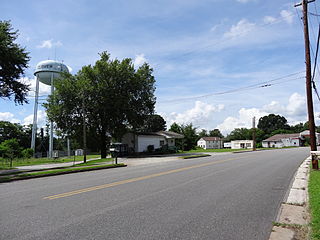
King George is a census-designated place (CDP) in and the county seat of King George County, Virginia, United States. It is sometimes referred to as King George Courthouse, because it is the location of the King George County Courthouse. The population as of the 2020 census was 4,970. The Journal Press was a local weekly newspaper published in King George and serving local areas until its final issue was published on Jan 11th, 2017.

Hanover is an unincorporated community and census-designated place (CDP) in Hanover County, Virginia, United States. It is the county seat and is located at the junction of U.S. Route 301 and State Route 54 south of the Pamunkey River. While historically known as Hanover Courthouse, the U.S. Geological Survey, Census Bureau, Postal Service and residents refer to it as "Hanover". The population as of the 2010 census was 252.

King William is a census-designated place (CDP) in and the county seat of King William County, Virginia, United States. The population as of the 2010 census was 252. Located in King William is the oldest courthouse in continuous use in the United States, built in 1725. The community is also known as King William Courthouse or, by an alternative spelling, King William Court House.
Gulf is an unincorporated community and census-designated place (CDP) in southwestern Chatham County, North Carolina, United States, southeast of the town of Goldston. As of the 2010 census, the Gulf CDP had a population of 144. The community is home to a general store and several historic homes. It received its name from its location at a wide bend in the Deep River.

Reinholds is an unincorporated community and census-designated place (CDP) in West Cocalico Township, Lancaster County, Pennsylvania, United States. As of the 2010 census the population was 1,803.
Bowmansville is an unincorporated community and census-designated place (CDP) in Brecknock Township, Lancaster County, Pennsylvania, United States. Bowmansville is home to a Pennsylvania Turnpike service plaza. The population was 2,077 as of the 2010 census.

Churchtown is an unincorporated community and census-designated place (CDP) in Caernarvon Township, Lancaster County, Pennsylvania, United States, along Pennsylvania Route 23. The population was 470 as of the 2010 census.
Glen Wilton is a census-designated place (CDP) in northern Botetourt County, Virginia, United States. The population was 129 at the 2020 census. The CDP is located along the James River, between Eagle Rock and Iron Gate. It is part of the Roanoke Metropolitan Statistical Area.
Founded in 1886, Weems is an unincorporated community and census-designated place (CDP) in Lancaster County in the U. S. state of Virginia. It was first drawn as a CDP prior to the 2020 census.

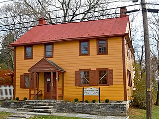
Libertytown is an unincorporated community and census-designated place (CDP) in Frederick County, in the U.S. state of Maryland. As of the 2010 census it had a population of 950. The unofficial mayor is Sean Dixon. The Abraham Jones House was listed on the National Register of Historic Places in 1973.


