Irvington, Virginia

Last updated

Irvington, Virginia
Irvington houses-turned-businesses.jpg
Businesses on State Route 200
VAMap-doton-Irvington.PNG
Location of Irvington, Virginia
Coordinates: 37°39′40″N76°25′10″W / 37.66111°N 76.41944°W / 37.66111; -76.41944
Country United States
State Virginia
County Lancaster
Area
[1]
  Total1.83 sq mi (4.73 km2)
  Land1.50 sq mi (3.90 km2)
  Water0.32 sq mi (0.83 km2)
Elevation
33 ft (10 m)
Population
 (2020)
  Total474
  Density264.45/sq mi (102.11/km2)
Time zone UTC-5 (Eastern (EST))
  Summer (DST) UTC-4 (EDT)
ZIP code
22480
Area code 804
FIPS code 51-40088 [2]
GNIS feature ID1468521 [3]
Website town.irvington.va.us

Irvington is a town on the Rappahannock River in Lancaster County, Virginia, United States. The population was 474 at the 2020 census. Located on a peninsula known as the Northern Neck, it has been designated a historic district.

Contents

History

From 1871 until 1893, the town was called "Carter's Creek Wharf" or simply "Carter's Creek", since steamboats docked at the relatively deep water confluence of a tributary that had much earlier been called "Cossotomen Creek" and later "Carter's Creek" after early settler John Carter, Sr., the father of the powerful colonial era politician King Carter, who was the Virginia agent for the Northern Neck Proprietary. The town formally adopted the name "Irvington" to honor Baltimore native Captain Levin Irvington following a 1891 referendum, since mail had been often confused between this town and that of Center Cross in relatively nearby Essex County. [4]

The original Chesapeake Academy, 1889–1907, was located in Irvington. [5]

Historic district

Irvington
LocationKing Carter Drive and Irvington Road, Irvington, Virginia
Coordinates 37°39′31″N76°25′21″W / 37.65861°N 76.42250°W / 37.65861; -76.42250
Area1,107.2 acres (448.1 ha)
Built1740
Architectural styleGreek Revival, Gothic Revival, et al.
NRHP reference No. 00000895 [6]
Added to NRHPDecember 8, 2000

The historic district, Irvington, also known as Carters Creek, is a 1,107.2-acre (448.1 ha) area that was listed on the National Register of Historic Places in 2000. In 2000, it included 149 contributing buildings, 3 contributing sites and one other contributing structure. [6]

Geography

Irvington is located at 37°39′41″N76°25′9″W / 37.66139°N 76.41917°W / 37.66139; -76.41917 (37.6615, −76.4191). [7]

According to the United States Census Bureau, the town has a total area of 1.8 square miles (4.7 km2), of which, 1.5 square miles (3.9 km2) of it is land and 0.3 square miles (0.9 km2) of it (18.13%) is water.

Demographics

Historical population
CensusPop.Note
1960 570
1970 504−11.6%
1980 56712.5%
1990 496−12.5%
2000 67335.7%
2010 432−35.8%
2020 4749.7%
U.S. Decennial Census [8]

According to the 2020 census, [9] there were 474 people, 368 total housing units with 248 occupied, and 260 families in the town. Of the total residents, 454 were white, 10 were mixed race, 10 were Hispanic or Latino, 6 were black, 2 were Native American, 1 was Asian, and 1 was some other race. 89.2% of residents owned a house instead of renting.

The median age in Irvington was 58.6 years. 35.5% of the population was 65 of older. 10.4% of the population was a veteran, with 91.7% of those being male. 56.7% of the residents had a bachelor's degree or other form of higher education.

The median household income was $118,750. The median income for families was $157,500. For married-couple families it was $174,375, and $57,632 for non-family households. 4.6% of the population were below the poverty line, 13% of which were age 65 and older.

According to the 2000 census, the population density was 449.0 people per square mile (173.2/km2). There were 325 housing units at an average density of 216.8 per square mile (83.7/km2). [2]

Features and amenities

Irvington is the home of the marine resort The Tides Inn. On King Carter Drive is the Steamboat Museum, which details the history of the steamboats that traveled the Chesapeake Bay and stopped in Irvington.

Lancaster National Bank (later Chesapeake National Bank and currently Chesapeake Bank) was formed in Irvington in 1900 to cater to the growing town. Irvington was also a stop for Chesapeake National Bank's Boat 'n Bank, a houseboat with bank tellers that cruised the Rappahannock River wharves, canneries and oyster houses. The town has a club, Rappahannock River Yacht Club, and a marina, Irvington Marina.

Children of the town attend Lancaster County Public Schools and there is one independent school located in Irvington. Reopened in 1965, Chesapeake Academy serves children from 3 years old through eighth grade. Chesapeake Academy's original 1890 schoolhouse is located on King Carter Drive; it is now the Hope & Glory Inn. Next door to the schoolhouse is the Irvington Methodist Church; its parsonage is now a women's clothing store, The Dandelion.

Since the 1970s winemaking has become a growing vocation in the region,[ citation needed ] with a number of wineries located nearby. Irvington is located within the Northern Neck George Washington Birthplace American Viticultural Area winemaking appellation.

Related Research Articles

<span class="mw-page-title-main">Westmoreland County, Virginia</span> County in Virginia, United States

Westmoreland County is a county located in the Northern Neck of the Commonwealth of Virginia. As of the 2020 census, the population sits at 18,477. Its county seat is Montross.

<span class="mw-page-title-main">Richmond County, Virginia</span> County in Virginia, United States

Richmond County is a county located on the Northern Neck in the U.S. state of Virginia. As of the 2020 census, the population sits at 8,923. Its county seat is Warsaw. The rural county should not be confused with the large city and state capital Richmond, Virginia. It was formed in 1692 when the first Rappahannock County was divided to form Richmond County and Essex County.

<span class="mw-page-title-main">Northumberland County, Virginia</span> County in Virginia, United States

Northumberland County is a county located in the Commonwealth of Virginia. At the 2020 census, the population was 11,839. Its county seat is Heathsville. The county is located on the Northern Neck and is part of the Northern Neck George Washington Birthplace AVA winemaking appellation.

<span class="mw-page-title-main">Middlesex County, Virginia</span> County in Virginia, United States

Middlesex County is a county located on the Middle Peninsula in the U.S. state of Virginia. As of the 2020 census, the population was 10,625. Its county seat is Saluda.

<span class="mw-page-title-main">Lancaster County, Virginia</span> County in Virginia, United States

Lancaster County is a county located on the Northern Neck in the Commonwealth of Virginia. As of the 2020 census, the population sits at 10,919. Its county seat is Lancaster.

<span class="mw-page-title-main">Essex County, Virginia</span> County in Virginia, United States

Essex County is a county located in the Middle Peninsula in the U.S. state of Virginia; the peninsula is bordered by the Rappahannock River on the north and King and Queen County on the south. As of the 2020 census, the population was 10,599. Its county seat is Tappahannock.

<span class="mw-page-title-main">Saxis, Virginia</span> Town in Virginia, United States

Saxis is a town in Accomack County, Virginia, United States. The population was 241 at the 2010 census.

<span class="mw-page-title-main">Port Royal, Virginia</span> Town in Virginia, United States

Port Royal is an incorporated town in Caroline County, Virginia, United States. The population was 126 at the 2010 census.

<span class="mw-page-title-main">Tappahannock, Virginia</span> Town in Virginia, United States

Tappahannock is the oldest town in Essex County, Virginia, United States. The population was 2,375 at the 2010 census, up from 2,068 at the 2000 census. Located on the Rappahannock River, Tappahannock is the county seat of Essex County. Its name comes from an Algonquian language word lappihanne, meaning "Town on the rise and fall of water" or "where the tide ebbs and flows." The Rappahannock is a tidal estuary from above this point and downriver to its mouth on Chesapeake Bay.

<span class="mw-page-title-main">West Point, Virginia</span> Town in Virginia, United States

West Point is an incorporated town in King William County, Virginia, United States. The population was 3,414 at the 2020 census.

<span class="mw-page-title-main">White Stone, Virginia</span> Town in Virginia, United States

White Stone is a town in Lancaster County, Virginia, United States. The population was 380 at the 2020 census. White Stone is one of many small towns located in Virginia's Northern Neck region.

<span class="mw-page-title-main">Cape Charles, Virginia</span> Town in Commonwealth of Virginia, United States

Cape Charles is a town / municipal corporation in Northampton County, Virginia, United States. The population was 1,009 as of the 2010 Census.

<span class="mw-page-title-main">Warsaw, Virginia</span> Town in Virginia, United States

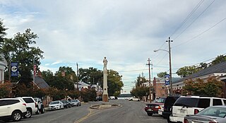
Warsaw is an incorporated town in and the county seat of Richmond County, Virginia, United States. The population was 1,637 at the 2020 census and is estimated to be 2,281 as of 2022.

<span class="mw-page-title-main">Falmouth, Virginia</span> Census-designated place in Virginia, United States

Falmouth is a census-designated place (CDP) in Stafford County, Virginia, United States. Situated on the north bank of the Rappahannock River at the falls, the community is north of and opposite the city of Fredericksburg. Recognized by the U.S. Census Bureau as a census-designated place (CDP), Falmouth's population was 4,956 as of the 2020 census.

<span class="mw-page-title-main">Colonial Beach, Virginia</span> Town in Virginia, United States

Colonial Beach, Virginia (CBVA) is a river and beach town located in the northwestern part of Westmoreland County on Virginia's Northern Neck peninsula. It is bounded by the Potomac River, Monroe Bay and Monroe Creek. It is located 65 mi (105 km) from Washington, D.C.; 70 mi (110 km) from the state capital of Richmond; and 35 nautical miles from the Chesapeake Bay.

<span class="mw-page-title-main">Kilmarnock, Virginia</span> Town in Virginia, United States

Kilmarnock is a town in Lancaster and Northumberland counties in the U.S. Commonwealth of Virginia. The population was 1,445 at the 2020 census. It is located near the mouth of the Rappahannock River and is located within the Northern Neck George Washington Birthplace American Viticultural Area winemaking appellation. There is a small hospital in the town. Lancaster Middle School, grades 4–8, is also located in town. Approximately 500 students attend the school.

<span class="mw-page-title-main">Northern Neck</span> Region in Virginia, United States

The Northern Neck is the northernmost of three peninsulas on the western shore of the Chesapeake Bay in the Commonwealth of Virginia. The Potomac River forms the northern boundary of the peninsula; the Rappahannock River demarcates it on the south. The land between these rivers was formed into Northumberland County in 1648, prior to the creation of Westmoreland County and Lancaster County.

<span class="mw-page-title-main">Rappahannock River</span> River in Virginia, United States

The Rappahannock River is a river in eastern Virginia, in the United States, approximately 195 miles (314 km) in length. It traverses the entire northern part of the state, from the Blue Ridge Mountains in the west where it rises, across the Piedmont to the Fall Line, and onward through the coastal plain to flow into the Chesapeake Bay, south of the Potomac River.

<span class="mw-page-title-main">Virginia State Route 200</span> State highway in eastern Virginia, US

State Route 200 is a primary state highway in the U.S. state of Virginia. The state highway runs 19.23 miles (30.95 km) from SR 3 in White Stone north to U.S. Route 360 at Burgess. SR 200 is the main north–south highway of the eastern end of the Northern Neck. The state highway connects the Lancaster County towns of White Stone, Irvington, and Kilmarnock, where the highway intersects SR 3 again, with eastern Northumberland County.

Founded in 1886, Weems is an unincorporated community and census-designated place (CDP) in Lancaster County in the U. S. state of Virginia. It was first drawn as a CDP prior to the 2020 census.

References

  1. "2019 U.S. Gazetteer Files". United States Census Bureau. Retrieved August 7, 2020.
  2. 1 2 "U.S. Census website". United States Census Bureau . Retrieved January 31, 2008.
  3. "US Board on Geographic Names". United States Geological Survey. October 25, 2007. Retrieved January 31, 2008.
  4. "History | Town of Irvington, Virginia".
  5. "Cottingham, Claybrook C." A Dictionary of Louisiana Biography (lahistory.org). Archived from the original on February 25, 2012. Retrieved December 19, 2010.
  6. 1 2 "National Register Information System". National Register of Historic Places . National Park Service. March 13, 2009.
  7. "Irvington". Geographic Names Information System . United States Geological Survey, United States Department of the Interior . Retrieved May 3, 2009.
  8. "Census of Population and Housing". Census.gov. Retrieved June 4, 2015.
  9. "Irvington town, Virgnia". data.census.gov. Retrieved May 28, 2024.