
Manassas Park is an independent city in the U.S. state of Virginia. As of the 2020 census, the population was 17,219. Manassas Park is bordered by the city of Manassas and Prince William County. Manassas Park is a part of the Washington-Arlington-Alexandria, DC-VA-MD-WV Metropolitan Statistical Area.
Louisa County is a county located in the Commonwealth of Virginia. As of the 2020 census, the population was 37,596. The county seat is Louisa.

Lawrence County is a county located in the U.S. state of Kentucky. As of the 2020 census, the population was 16,293. Its county seat is Louisa. The county is named for James Lawrence, and co-founded by Isaac Bolt, who served as a Lawrence County Commissioner and Justice of the Peace. Lawrence County is the home of bluegrass music and country music star Tyler Childers. It is the birthplace of the late Chief Justice of the United States Frederick Moore Vinson and former Kentucky Governor Paul E. Patton. In regard to alcoholic beverage sales, Lawrence County is considered a "moist" county, meaning alcohol sales are only allowed within the city limits of Louisa. There are no alcohol sales within the rest of the county. Only two stores sell liquor, and most convenience stores sell beer and malted beverages.

Easton is a town in Aroostook County, Maine, United States. The population was 1,320 at the 2020 census.

Barrington is a town in Yates County, New York, United States. The population was 1,681 at the 2010 census.

Muddy Creek Township is a township in Butler County, Pennsylvania, United States. The population was 2,210 at the 2020 census.

West Sunbury is a borough in Butler County, Pennsylvania, United States. The population was 192 at the 2010 census.

North Charleroi is a borough in Washington County, Pennsylvania, United States. The population was 1,302 at the 2020 census.
Port Royal is an incorporated town in Caroline County, Virginia, United States. The population was 126 at the 2010 census.

Merrifield is a census-designated place (CDP) in Fairfax County, Virginia, United States. The population was 20,488 at the 2020 census.

Remington is a small incorporated town in Fauquier County, Virginia, United States. The population was 598 at the 2010 census. It is near the highways, U.S. Route 15, U.S. Route 17, U.S. Route 29, and Virginia State Route 28. Remington is less than a mile northeast of the Culpeper County line.

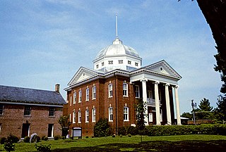
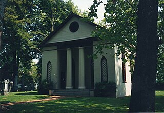
Louisa is a town in Louisa County, Virginia, United States. The population was 1,555 at the 2010 census. It is the county seat of Louisa County.

Gainesville is a census-designated place (CDP) in western Prince William County, Virginia, United States. The population was 17,287 in the 2020 census.
Clinchport is a town in Scott County, Virginia, United States. The population was 64 at the 2020 census. Clinchport is the least-populated municipality in Virginia. It is part of the Kingsport-Bristol-Bristol, TN-VA Metropolitan Statistical Area, which is a component of the Johnson City-Kingsport-Bristol, TN-VA Combined Statistical Area – commonly known as the "Tri-Cities" region.

Danville is a town in Boone County, West Virginia, United States. The population was 660 at the 2020 census. Danville was incorporated in 1911 and named for Dan Rock, the town's first postmaster. Danville was formerly known as Newport and Red House.

Mallory is a census-designated place (CDP) in Logan County, West Virginia, United States. The population was 1,654 at the 2010 census. The CDP contains the unincorporated communities, from west to east, of Huff Junction, Mallory, Davin, Mineral City, Claypool, Combs Addition, and Gillman Bottom.

Union is a town in Monroe County, West Virginia, United States. Union’s population is 427 as of 2020. It is the county seat of Monroe County.

Fort Gay is a town in Wayne County, West Virginia, United States, situated along the Tug Fork and Big Sandy rivers. The town adjoins Louisa, Kentucky. The population was 677 at the 2020 census.

Mineral Ridge is an unincorporated community and census-designated place in southern Trumbull and northern Mahoning counties in the U.S. state of Ohio. The population was 3,951 at the 2020 census. It is a suburb of the Youngstown–Warren metropolitan area. Mineral Ridge was named for valuable coal deposits near the original town site.
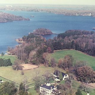
Jerdone Castle is a plantation located in Bumpass, Louisa County, Virginia, originally established c. 1742. Jerdone Castle is a Virginia Historic Landmark and registered on the U.S. National Register of Historical Places. Originally 1,100 acres (450 ha), much of the plantation's original land is submerged under Lake Anna. The estate currently contains 175 acres (71 ha).


