Bumpass is an unincorporated area in Louisa County, Virginia, United States. Its post office is still in service. National Historical Places registered in Bumpass include the Duke House and Jerdone Castle. The latter is a plantation where George Washington spent the night on June 10 during his 1791 Southern tour.
The Virginia Seismic Zone in the U.S. state of Virginia covers about 8,000 square kilometers (3,100 sq mi) in the Piedmont province. Earthquakes in the state are irregular and rarely reach over 4.5 in magnitude.

Greenwood is an unincorporated community in Albemarle County, Virginia, United States. It is home to the Greenwood Country Store and the Greenwood Community Center, which has the area's only roller skating rink. Greenwood has a post office with ZIP code 22943 The Greenwood Tunnel, built by Claudius Crozet for the Blue Ridge Railroad and used by the Chesapeake and Ohio Railway until its abandonment during World War II, is near Greenwood by the Buckingham Branch Railroad tracks.
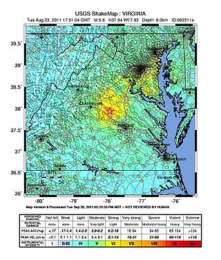
On August 23, 2011, a magnitude 5.8 earthquake hit the Piedmont region of the U.S. state of Virginia at 1:51:04 p.m. EDT. The epicenter, in Louisa County, was 38 mi (61 km) northwest of Richmond and 5 mi (8 km) south-southwest of the town of Mineral. It was an intraplate earthquake with a maximum perceived intensity of VIII (Severe) on the Mercalli intensity scale. Several aftershocks, ranging up to 4.5 in magnitude, occurred after the main tremor.
Burnt House is an unincorporated community in Ritchie County, West Virginia, United States. Burnt House is located on West Virginia Route 47 and Grass Run, 11.8 miles (19.0 km) south-southeast of Harrisville. The Burnt House Post Office closed 5/23/1986.
Meadowdale is an unincorporated community in Jackson County, West Virginia, United States. Meadowdale is located on County Route 13 and the Right Fork Sandy Creek, 8.1 miles (13.0 km) northeast of Ripley. Meadowdale once had a post office, which is now closed.
Ripley Landing is an unincorporated community in Jackson County, West Virginia, United States. Ripley Landing is located along West Virginia Route 2 near the confluence of the Ohio River and Mill Creek, 6.1 miles (9.8 km) southwest of Ravenswood. Ripley Landing once had a post office, which is now closed.
Foster Chapel is an unincorporated community in Jackson County, West Virginia, United States. Foster Chapel is located on County Route 32, 5.7 miles (9.2 km) southwest of Ripley. Foster Chapel once had a post office, which is now closed.
Topins Grove is an unincorporated community in Jackson County, West Virginia, United States. Topins Grove is located on Little Pond Creek and County Highway 6, 7.7 miles (12.4 km) north-northeast of Ravenswood. Topins Grove once had a post office, which is now closed.
Utica is an unincorporated community in Jackson County, West Virginia, United States. Utica is located on Cabin Fork and County Highway 1/2, 8.7 miles (14.0 km) northeast of Ravenswood. Utica once had a post office, which is now closed.
Lockhart is an unincorporated community in Jackson County, West Virginia, United States. Lockhart is located on the Left Fork Sandy Creek and County Highway 21, 8 miles (13 km) east of Ravenswood. Lockhart once had a post office, which is now closed.
Odaville is an unincorporated community in Jackson County, West Virginia, United States. Odaville is located on the Left Fork Sandy Creek and County Highway 21, 8.7 miles (14.0 km) north-northeast of Ripley. Odaville once had a post office, which is now closed.
Wilding is an unincorporated community in Jackson County, West Virginia, United States. Wilding is located on County Highway 3, 4 miles (6.4 km) east of Ravenswood. Wilding once had a post office, which is now closed.
Pleasant View is an unincorporated community in Jackson County, West Virginia, United States. Pleasant View is located on the Ohio River and West Virginia Route 2, 2.3 miles (3.7 km) southwest of Ravenswood. Pleasant View once had a post office, which is now closed.
Plum Orchard is an unincorporated community in Jackson County, West Virginia, United States. Plum Orchard is located on County Highway 34/14, 9 miles (14 km) south-southeast of Ripley. Plum Orchard once had a post office, which is now closed.
Louther is an unincorporated community in Jackson County, West Virginia, United States. Louther is located on County Highway 28 in the Frozen Camp Wildlife Management Area, 8.8 miles (14.2 km) east of Ripley. Louther once had a post office, which is now closed.
Buchanan, originally named Mouth of Bear, is an unincorporated community located in Lawrence County, Kentucky, United States at the mouth of Bear Creek where it joins the Big Sandy River, five miles downstream from the mouth of Blaine Creek.
Mount Pleasant is an unincorporated community located along County Route 519 on the border of Alexandria Township and Holland Township, in Hunterdon County, New Jersey. The Mount Pleasant Historic District was listed on the National Register of Historic Places in 1987.
Spilman is an unincorporated community on the Ohio River in Mason County, West Virginia, United States. The village is located along Spilman Lane, Mason County Route 62/24, parallel to West Virginia Route 62 in Waggener District, about three quarters of a mile southeast of West Columbia.

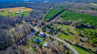
Poindexter is an unincorporated community in Louisa County, Virginia, United States It is located at the 4-way intersection of minor Virginia State Routes 613 and 640. State Route 717 spurs off of State Route 613 nearby.


