Louisa, Virginia

Last updated

Louisa, Virginia
Louisa-VA.jpg
Main Street, Downtown Louisa
Seal of Louisa, Virginia.png
VAMap-doton-Louisa.PNG
Location in Virginia
Coordinates: 38°1′27″N78°0′6″W / 38.02417°N 78.00167°W / 38.02417; -78.00167
CountryUnited States
State Virginia
County Louisa
Founded1873
Government
   Mayor R. Garland Nuckols
   Town Manager Liz Nelson
Area
[1]
  Total1.84 sq mi (4.77 km2)
  Land1.83 sq mi (4.73 km2)
  Water0.01 sq mi (0.04 km2)
Elevation
466 ft (142 m)
Population
 (2010)
  Total1,555
  Estimate 
(2019) [2]
1,733
  Density948.55/sq mi (366.28/km2)
Time zone UTC−5 (Eastern (EST))
  Summer (DST) UTC−4 (EDT)
ZIP code
23093
Area code 540
FIPS code 51-47144 [3]
GNIS feature ID1498507 [4]
Website http://louisatown.org/

Louisa (originally named Louisa Court House) is a town in Louisa County, Virginia, United States. The population was 1,555 at the 2010 census. It is the county seat of Louisa County. [5]

Contents

History

Louisa Court House was named because of the county courthouse constructed in 1742, near the intersection of Courthouse Road (now SR 208) and Main Street/Louisa Road (now SR-22/US-33). The village of Louisa Court House had been the county seat for over a century when it became a strategic location during the American Civil War for Virginia's supply and communication lines.

1852 Map of the Virginia Central Railroad Virginia Central Map 1852 cropped.png
1852 Map of the Virginia Central Railroad

Chartered in 1836 as the Louisa Railroad by the Virginia General Assembly, the Virginia Central Railroad mainline passed through the village. On June 10, 1864, thousands of men and horses of Gen. Fitzhugh Lee's cavalry division camped around the courthouse prior to the Battle of Trevilian Station. [6] The VCR merged into the Chesapeake and Ohio Railroad in 1868 (reorganized as the Chesapeake and Ohio Railway in 1878). The C&O operated the mainline through Louisa over one hundred years, until the Chessie System merged into CSX in the 1980s.

The incorporated Town of Louisa was created by Act of the General Assembly in 1873. [7] Many businesses found advantage in locating near the mainline, especially heavy industries that could transport using the railroad. As the road infrastructure improved and especially since the 1956 development of the interstate highway system's I-64, local businesses transport mainly via semi-truck using US 33.

East of the Town of Louisa on Jeff Davis Highway is the Cooke Industrial Rail Park, a 1400 acre contiguous tract of land with over 1 mile of rail frontage, served by CSX and Buckingham Branch Railroad. [8]

Historic places

There are many places of local historic interest and some that are of national significance: Bloomington, Boxley Place, the 1905 Louisa County Courthouse, and Louisa High School are listed on the National Register of Historic Places. [9]

Geography

Louisa is located at 38°1′27″N78°0′6″W / 38.02417°N 78.00167°W / 38.02417; -78.00167 (38.024057, 78.001584). [10]

According to the United States Census Bureau, the city has a total area of 1.8 square miles (4.7 km2), of which 1.8 square miles (4.7 km2) is land and 0.55% is water.

Climate

Climate data for Louisa, Virginia (1991–2020 normals, extremes 1916–present)
MonthJanFebMarAprMayJunJulAugSepOctNovDecYear
Record high °F (°C)80
(27)
82
(28)
89
(32)
96
(36)
99
(37)
101
(38)
108
(42)
105
(41)
104
(40)
98
(37)
88
(31)
79
(26)
108
(42)
Mean daily maximum °F (°C)45.2
(7.3)
49.4
(9.7)
58.2
(14.6)
69.8
(21.0)
76.0
(24.4)
83.2
(28.4)
86.7
(30.4)
85.3
(29.6)
79.0
(26.1)
68.6
(20.3)
57.4
(14.1)
48.1
(8.9)
67.2
(19.6)
Daily mean °F (°C)35.3
(1.8)
38.2
(3.4)
45.5
(7.5)
56.1
(13.4)
64.0
(17.8)
71.9
(22.2)
76.0
(24.4)
74.4
(23.6)
67.6
(19.8)
56.5
(13.6)
45.8
(7.7)
38.1
(3.4)
55.8
(13.2)
Mean daily minimum °F (°C)25.4
(−3.7)
27.0
(−2.8)
32.8
(0.4)
42.3
(5.7)
52.0
(11.1)
60.7
(15.9)
65.2
(18.4)
63.6
(17.6)
56.3
(13.5)
44.4
(6.9)
34.1
(1.2)
28.1
(−2.2)
44.3
(6.8)
Record low °F (°C)−20
(−29)
−21
(−29)
−5
(−21)
13
(−11)
26
(−3)
36
(2)
37
(3)
36
(2)
29
(−2)
18
(−8)
4
(−16)
−9
(−23)
−21
(−29)
Average precipitation inches (mm)3.00
(76)
2.74
(70)
3.70
(94)
3.38
(86)
3.97
(101)
4.33
(110)
4.18
(106)
3.68
(93)
4.49
(114)
3.81
(97)
3.59
(91)
3.33
(85)
44.20
(1,123)
Average snowfall inches (cm)4.5
(11)
6.1
(15)
1.5
(3.8)
0.3
(0.76)
0.0
(0.0)
0.0
(0.0)
0.0
(0.0)
0.0
(0.0)
0.0
(0.0)
0.0
(0.0)
0.1
(0.25)
3.3
(8.4)
15.8
(40)
Average precipitation days (≥ 0.01 in)9.38.310.010.512.210.610.99.29.78.38.810.1117.9
Average snowy days (≥ 0.1 in)1.81.80.60.00.00.00.00.00.00.00.01.35.5
Source: NOAA [11] [12]

Demographics

Historical population
CensusPop.Note
1880 315
1900 261
1910 31821.8%
1920 289−9.1%
1930 3014.2%
1940 36521.3%
1950 344−5.8%
1960 57667.4%
1970 6339.9%
1980 93247.2%
1990 1,08816.7%
2000 1,40128.8%
2010 1,55511.0%
2019 (est.)1,733 [2] 11.4%
U.S. Decennial Census [13]

At the 2000 census there were 1,401 people, 584 households, and 331 families in the town. The population density was 766.8 people per square mile (295.6/km2). There were 620 housing units at an average density of 339.4 per square mile (130.8/km2). The racial makeup of the town was 66.81% White, 29.48% African American, 0.79% Native American, 0.71% Asian, 0.79% from other races, and 1.43% from two or more races. Hispanic or Latino of any race were 1.43%. [3]

Of the 584 households 30.0% had children under the age of 18 living with them, 35.6% were married couples living together, 16.4% had a female householder with no husband present, and 43.3% were non-families. 37.0% of households were one person and 18.3% were one person aged 65 or older. The average household size was 2.25 and the average family size was 2.93.

The age distribution was 24.8% under the age of 18, 7.9% from 18 to 24, 28.5% from 25 to 44, 19.2% from 45 to 64, and 19.6% 65 or older. The median age was 38 years. For every 100 females, there were 81.5 males. For every 100 females aged 18 and over, there were 73.1 males.

The median household income was $29,519 and the median family income was $42,396. Males had a median income of $27,578 versus $23,188 for females. The per capita income for the town was $17,763. About 14.7% of families and 18.7% of the population were below the poverty line, including 27.9% of those under age 18 and 17.0% of those age 65 or over.

Points of interest

A local train of the Buckingham Branch railroad passes the C&O Depot and watertower in Louisa. BB7 Louisa WJGrimes.JPG
A local train of the Buckingham Branch railroad passes the C&O Depot and watertower in Louisa.
Cooper Vineyards in Louisa, is the first winery on the East Coast and the second in the country to be awarded the fourth and highest, Platinum certification by Leadership in Energy and Environmental Design (LEED) 20110504-RD-LSC-0654 - Flickr - USDAgov.jpg
Cooper Vineyards in Louisa, is the first winery on the East Coast and the second in the country to be awarded the fourth and highest, Platinum certification by Leadership in Energy and Environmental Design (LEED)

Louisa is home to the North Anna Nuclear Generating Station which produces electricity and offers jobs for the county's inhabitants. The warm water produced from the power plant and discharged into the water of Lake Anna creates what some call Central Virginia's best fishing.

Louisa is also home to the Twin Oaks Community, an intentional community of 100 people living on 465 acres (1.88 km2). The community has been in Louisa since 1967.

The 2011 Virginia earthquake had its epicenter just 7 miles (11 kilometers) south-southeast of Louisa. [14] This quake registered 5.8 magnitude and caused the evacuations of buildings on Capitol Hill in Washington, D.C., as well as New York City and was felt as far north as Canada.

Public services

Jefferson-Madison Regional Library is the regional library system that provides services to the citizens of Louisa.

Notable people

Related Research Articles

Belmont is a village within the town of Amity in Allegany County, New York, United States. Belmont is the county seat of Allegany County. The population was 969 at the 2010 census. The name means "beautiful hill". The village is centrally located in Amity and is northeast of Olean.

<span class="mw-page-title-main">Colfax County, New Mexico</span> County in New Mexico, United States

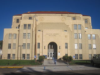
Colfax County is a county in the U.S. state of New Mexico. As of the 2020 census, the population was 12,387. Its county seat is Raton. It is south from the Colorado state line. This county was named for Schuyler Colfax (1823–1885), seventeenth Vice President of the United States under U.S. President Ulysses S. Grant.

<span class="mw-page-title-main">Lawrence County, Kentucky</span> County in Kentucky, United States

Lawrence County is a county located in the U.S. state of Kentucky. As of the 2020 census, the population was 16,293. Its county seat is Louisa. The county is named for James Lawrence, and co-founded by Isaac Bolt, who served as a Lawrence County Commissioner and Justice of the Peace. Lawrence County is the home of bluegrass music and country music star Tyler Childers. It is the birthplace of the late Chief Justice of the United States Frederick Moore Vinson and former Kentucky Governor Paul E. Patton. In regard to alcoholic beverage sales, Lawrence County is considered a "moist" county, meaning alcohol sales are only allowed within the city limits of Louisa. There are no alcohol sales within the rest of the county. Only two stores sell liquor, and most convenience stores sell beer and malted beverages.

<span class="mw-page-title-main">Louisa County, Iowa</span> County in Iowa, United States

Louisa County is a county located in the U.S. state of Iowa. As of the 2020 census, the population was 10,837. The county seat is Wapello.

<span class="mw-page-title-main">Cassandra, Pennsylvania</span> Borough in Pennsylvania, United States

Cassandra is a borough in Cambria County, Pennsylvania, United States. The population was 147 at the 2010 census. It is part of the Johnstown, Pennsylvania Metropolitan Statistical Area.

<span class="mw-page-title-main">Cresson Township, Cambria County, Pennsylvania</span> Township in Pennsylvania, United States

Cresson Township is a township in Cambria County, Pennsylvania, United States. The population was 2,820 at the 2020 census. The township surrounds the boroughs of Cresson and Sankertown but is separate from them. It is part of the Johnstown, Pennsylvania Metropolitan Statistical Area.

<span class="mw-page-title-main">Mifflintown, Pennsylvania</span> Borough in Pennsylvania, United States

Mifflintown is a borough in and the county seat of Juniata County, Pennsylvania, United States. The population was 842 at the 2020 census.

<span class="mw-page-title-main">Appomattox, Virginia</span> Town in Virginia

Appomattox is a town in Appomattox County, Virginia, United States. The population was 1,733 at the 2010 census. It is the county seat of Appomattox County.

<span class="mw-page-title-main">Alberta, Virginia</span> Town in Virginia, United States

Alberta is a town in Brunswick County, Virginia, United States. The population was 302 at the 2020 census. It is home to the Christanna Campus of Southside Virginia Community College.

<span class="mw-page-title-main">Bowling Green, Virginia</span> Town in Virginia, United States

Bowling Green is an incorporated town in Caroline County, Virginia, United States. The population was 1,111 at the 2010 census.

<span class="mw-page-title-main">Stanardsville, Virginia</span> Town in Virginia, United States

Stanardsville is a town in Greene County, Virginia, United States. The population was 349 at the 2020 census, down from 367 at the 2010 census. It is the county seat of Greene County. The name is from Robert Stanard, a benefactor who donated land for public use. It is part of the Charlottesville, Virginia metropolitan area.

<span class="mw-page-title-main">Halifax, Virginia</span> Town in Virginia, United States

Halifax is a town in Halifax County, Virginia, United States, along the Banister River. The population was 1,309 at the 2010 census. It is the county seat of Halifax County.

<span class="mw-page-title-main">Mineral, Virginia</span> Town in Virginia, United States

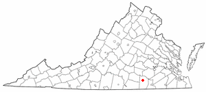
Mineral is a town in Louisa County, Virginia, United States. The population was 467 at the 2010 census.

<span class="mw-page-title-main">La Crosse, Virginia</span> Town in Virginia, United States

La Crosse is a town in Mecklenburg County, Virginia, United States. Its name is derived from the fact that it was a place where railroads once crossed, and there is still a caboose in the center of the town. La Crosse is adjacent to the neighboring town South Hill.

<span class="mw-page-title-main">Orange, Virginia</span> Town in Virginia, United States

Orange is a town and the county seat of Orange County, Virginia, United States. The population was 5,062 at the 2020 census, representing a 7.2% increase since the 2010 census. Orange is 28 miles (45 km) northeast of Charlottesville, 88 miles (142 km) southwest of Washington, D.C., and 4 miles (6 km) east of Founding Father and fourth U.S. president James Madison's plantation of Montpelier.

<span class="mw-page-title-main">Madison, West Virginia</span> City in West Virginia, United States

Madison is a city and former coal town in Boone County, West Virginia, United States. The population was 2,911 at the 2020 census. It is the county seat of Boone County.

<span class="mw-page-title-main">Flatwoods, West Virginia</span> Town in West Virginia, United States

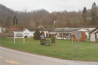
Flatwoods is a town in Braxton County, West Virginia, United States, located approximately one mile from exit 67 of Interstate 79.

<span class="mw-page-title-main">Wayne, West Virginia</span> Town in West Virginia, United States

Wayne is a town in and the county seat of Wayne County, West Virginia, United States. The population was 1,441 at the 2020 census. It is part of the Huntington–Ashland metropolitan area.

<span class="mw-page-title-main">Pamplin City, Virginia</span> Town in Virginia, United States

Pamplin City is a town in Appomattox and Prince Edward counties in the U.S. state of Virginia. The population was 138 at the 2020 United States census.

<span class="mw-page-title-main">Gordonsville, Virginia</span> Town in Virginia, United States

Gordonsville is a town in Orange County in the Commonwealth of Virginia in the United States. Located about 19 miles northeast of Charlottesville and 65 miles northwest of Richmond, the population was 1,402 at the 2020 census.

References

  1. "2019 U.S. Gazetteer Files". United States Census Bureau. Retrieved August 7, 2020.
  2. 1 2 "Population and Housing Unit Estimates". United States Census Bureau. May 24, 2020. Retrieved May 27, 2020.
  3. 1 2 "U.S. Census website". United States Census Bureau . Retrieved January 31, 2008.
  4. "US Board on Geographic Names". United States Geological Survey. October 25, 2007. Retrieved January 31, 2008.
  5. "Find a County". National Association of Counties. Retrieved June 7, 2011.
  6. Historical Marker Database: Louisa Court House – Raiders Intercepted. Accessed June 19, 2022.
  7. Town of Louisa: Town History. Accessed June 19, 2022.
  8. Louisa County: Cooke Industrial Rail Park. Accessed June 19, 2022.
  9. "National Register Information System". National Register of Historic Places . National Park Service. July 9, 2010.
  10. "US Gazetteer files: 2010, 2000, and 1990". United States Census Bureau. February 12, 2011. Retrieved April 23, 2011.
  11. "NowData – NOAA Online Weather Data". National Oceanic and Atmospheric Administration. Retrieved July 5, 2021.
  12. "Station: Louisa, VA". U.S. Climate Normals 2020: U.S. Monthly Climate Normals (1991-2020). National Oceanic and Atmospheric Administration. Retrieved July 5, 2021.
  13. "Census of Population and Housing". Census.gov. Retrieved June 4, 2015.
  14. Magnitude 5.8 - VIRGINIA Archived October 6, 2014, at the Wayback Machine