Largent is an unincorporated community village located chiefly in Morgan County and partly in Hampshire County in the U.S. state of West Virginia. Largent is located on the Cacapon River, approximately 18 miles southwest of Berkeley Springs along Cacapon Road. It is located by Old Enon Cemetery, Stony Creek, and the Cacapon River. Largent's original town name was Enon. It was most likely renamed when Postal Service found another town of Enon elsewhere in the state. The Enon name is found in local church and cemetery names. The Enon school is found on USGS maps from 1914 through 1923. The school has been open at least since the 1930s. The Baileys bought the building in 1958 and it has been a residence since.
Owens is a small unincorporated crossroads community at the intersection of Dahlgren Road, Windsor Drive, and Owens Drive in King George County, Virginia, United States. State Routes 206 and 218 meet at this intersection, with 206 going east towards U.S. Route 301 and Dahlgren, 218 going south towards US 301 and Colonial Beach and 206 and 218 joined together going west towards Arnolds Corner and Fredericksburg. The eastern part of the community is within the Dahlgren census-designated place.
Eldorendo is an unincorporated community located in Decatur County in southwest Georgia, United States.

Orlando is an unincorporated community located in Braxton and Lewis counties, West Virginia, United States. It is located on Oil Creek, a tributary of the Little Kanawha River.
Creek Stand is an unincorporated community in Macon County, Alabama, United States.
Belva is an unincorporated community and census-designated place in west Nicholas County and north Fayette County, West Virginia, United States; while the CDP only includes the Nicholas County portion, the Fayette County portion is considered part of the community. The town is situated at the bottomland surrounding the convergence of Bells Creek with Twentymile Creek and, subsequently, Twenty Mile Creek with the Gauley River. Belva is also the location of the convergence of two state highways: West Virginia Route 16 and West Virginia Route 39.
Lutts is an unincorporated community in Wayne County, Tennessee, United States. It is also known as "Pinhook."
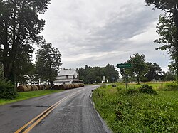
Foster Chapel is an unincorporated community in Jackson County, West Virginia, United States. Foster Chapel is located on County Route 32, 5.7 miles (9.2 km) southwest of Ripley. Foster Chapel once had a post office, which is now closed.

Oley, also called Friedensburg, is a census-designated place (CDP) that is located on Routes 73 and 662 in northern Oley Township, Berks County, United States.
Mexia is an unincorporated community in Monroe County, Alabama, United States. Mexia is located on Alabama State Route 47, 4 miles (6.4 km) west-southwest of Monroeville. Mexia has a post office with ZIP code 36458. Mexia has two small historic cemeteries on Thompson Road and Rolland Road. The largest church in Mexia is Mexia Baptist Church located on Old Salem Road. In Mexia there is also New Chapel Baptist Church located on Snowden Road, and Old Salem Baptist Church located on Old Salem Creek Road.
Laurel Fork is an unincorporated community in Carroll County, Virginia. It is located off U.S. Route 58 and is 12.4 miles (20.0 km) east-southeast of Hillsville, Virginia. Laurel Fork has a post office with the ZIP code 24352.
Ben Lomond is an unincorporated community in Mason County, West Virginia, United States. It is located on the eastern bank of the Ohio River at the junction of West Virginia Route 2 and County Route 56,, some 9.7 miles (15.6 km) south-southwest of Point Pleasant.
Suver is an unincorporated community in Polk County, Oregon, United States. It is located about 10 miles north of Corvallis and about 8 miles south of Monmouth, 1 mile east of Oregon Route 99W.
Adaton is an unincorporated community originally known as Steele's Mill and later as Aderton. Steele's mill was founded around 1852. The town is located about four miles west of Starkville at the intersection of Mississippi Highway 182 and Self Creek Road, immediately south of Oktibbeha County Lake in Oktibbeha County, Mississippi, United States.

Harbourton is an unincorporated community located within Hopewell Township in Mercer County, New Jersey, United States. It is located along County Route 579 at the intersection with Harbourton-Mount Airy Road. The Harbourton Historic District, encompassing the community, was listed on the state and national registers of historic places in 1974.

Wertsville is an unincorporated community located along County Route 602 in East Amwell Township of Hunterdon County, New Jersey, United States.

Manchester is an unincorporated community in Walker County, Alabama, United States. Manchester is located along Alabama State Route 195, 6.1 miles (9.8 km) north-northeast of Jasper.
Spilman is an unincorporated community on the Ohio River in Mason County, West Virginia, United States. The village is located along Spilman Lane, Mason County Route 62/24, parallel to West Virginia Route 62 in Waggener District, about three quarters of a mile southeast of West Columbia.

Old Bridge, also known as the Historic Village of Old Bridge, is an unincorporated community located within East Brunswick in Middlesex County, in the U.S. state of New Jersey. It is on the South River, a tributary of the Raritan River. The community is named after the first bridge built here to cross the river, the South River Bridge. After other bridges were built crossing the river, it became known as the Old Bridge. The Old Bridge Historic District, encompassing much of the village, is listed on the state and national registers of historic places.
Fox is an unincorporated community in Grayson County, Virginia, United States located at the intersection of U.S. Route 58 and State Route 711.