
Emporia is an independent city in the Commonwealth of Virginia, surrounded by Greensville County, in the United States. It and a predecessor town have been the county seat of Greensville County since 1791. As of the 2010 census, the population was 5,927, making it the second-least populous city in Virginia. The Bureau of Economic Analysis combines the city of Emporia with surrounding Greensville county for statistical purposes.
Boyce is a town in Clarke County, Virginia, United States. The population was 589 at the 2010 census, up from 426 at the 2000 census.

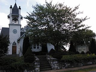
Pamplin City is a town in Appomattox and Prince Edward counties in the U.S. state of Virginia. The population was 219 at the 2010 census.

The Virginia Peninsula is a peninsula in southeast Virginia, USA, bounded by the York River, James River, Hampton Roads and Chesapeake Bay. It is sometimes known as the Lower Peninsula to distinguish it from two other peninsulas to the north, the Middle Peninsula and the Northern Neck.
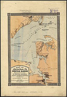
Sewells Point is a peninsula of land in the independent city of Norfolk, Virginia in the United States, located at the mouth of the salt-water port of Hampton Roads. Sewells Point is bordered by water on three sides, with Willoughby Bay to the north, Hampton Roads to the west, and the Lafayette River to the south. It is the site of Naval Station Norfolk.
Midlothian, Virginia is an unincorporated area in Chesterfield County, Virginia, U.S. Settled as a coal town, Midlothian village experienced suburbanization effects and is now part of the western suburbs of Richmond, Virginia south of the James River in the Greater Richmond Region. Because of its unincorporated status, Midlothian has no formal government, and the name is used to represent either the original small Village of Midlothian, located near US-60 and Woolridge Road, or a vast expanse of Chesterfield County in the northwest portion of Southside Richmond covered by three zip codes served by the Midlothian post office. These zip codes are not coterminous with the Midlothian Magesterial District associated with the Chesterfield County government.

Disputanta is an unincorporated community in Prince George County, Virginia, United States in the Richmond-Petersburg region and is a portion of the Richmond Metropolitan Statistical Area (MSA). The postal ZIP Code of Disputanta, Virginia is 23842.
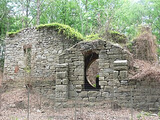
The Southside Railroad was formed in Virginia in 1846. Construction was begun in 1849 and completed in 1854. The 5 ft gauge railroad connected City Point, a port on the James River with the farm country south and west of Petersburg, Virginia, to Lynchburg, Virginia, a distance of about 132 miles (212 km).

The Dismal Swamp Canal is located along the eastern edge of the Great Dismal Swamp in Virginia and North Carolina in the United States. It is the oldest continually operating man-made canal in the United States, opened in 1805. It is part of the Intracoastal Waterway, an inland route, which parallels the east coast and offers boaters shelter from the Atlantic Ocean from Manasquan Inlet, New Jersey, to Brownsville, Texas. The route runs through bays, lakes, rivers, streams, and canals, and includes the Intracoastal Waterway running from Norfolk, Virginia, to the Florida Keys.

New Bohemia is an unincorporated community in Prince George County, Virginia, United States, along U.S. Route 460. It was also once known as Wells or Wells Station.

Transportation in the Commonwealth of Virginia is by land, sea and air. Virginia's extensive network of highways and railroads were developed and built over a period almost 400 years, beginning almost immediately after the founding of Jamestown in 1607, and often incorporating old established trails of the Native Americans.

The Tri-Cities of Virginia is an area in the Greater Richmond Region which includes the three independent cities of Petersburg, Colonial Heights, and Hopewell and portions of the adjoining counties of Chesterfield, Dinwiddie, and Prince George in south-central Virginia. Other unincorporated communities located in the Tri-Cities area include Ettrick, Fort Lee, and City Point, the latter formerly a historic incorporated town which was annexed to become part of the City of Hopewell.
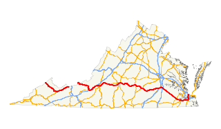
U.S. Route 460 in Virginia runs west-east through the southern part of the Commonwealth. The road has two separate pieces in Virginia, joined by a relatively short section in West Virginia. Most of US 460 is a four-lane divided highway and is a major artery in the southern third of the state.

Nottoway, or Nottoway Court House, is a census-designated place (CDP) in and the county seat of Nottoway County, Virginia, United States. The population as of the 2010 Census was 84.

Spout Spring is an unincorporated community in Appomattox County, Virginia, United States. This town was a stop on the Southside Railroad in the mid-nineteenth Century. This became the Atlantic, Mississippi and Ohio Railroad in 1870 and then a line in the Norfolk and Western Railway and now the Norfolk Southern Railway.

Prospect is an unincorporated community in Prince Edward County, Virginia, United States. This town was a stop on the Southside Railroad in the mid-nineteenth Century. This became the Atlantic, Mississippi and Ohio Railroad in 1870 and then a line in the Norfolk and Western Railway and now the Norfolk Southern Railway. The rail line from Burkville to Pamplin City, the stop after Prospect, was converted by Virginia Department of Parks and Recreation into High Bridge Trail State Park.
Ford is an unincorporated community in Dinwiddie County, Virginia, United States. Ford is located on U.S. Route 460 19.2 miles (30.9 km) west-southwest of Petersburg. This town was a stop on the Southside Railroad in the mid-nineteenth Century. This became the Atlantic, Mississippi and Ohio Railroad in 1870 and then a line in the Norfolk and Western Railway and now the Norfolk Southern Railway.
Ewell was an unincorporated town in James City County west of Williamsburg, in the U.S. state of Virginia.

Concord is a census-designated place (CDP) in Appomattox and Campbell counties in the U.S. state of Virginia. The population as of the 2010 census was 1,458.
Sutherland is an unincorporated community in Dinwiddie County, Virginia, United States. Sutherland is located on U.S. Route 460 9 miles (14 km) west-southwest of Petersburg.


