Augusta County, Virginia

Last updated

Augusta County
Augusta County VA Courthouse.jpg
The Augusta County Courthouse in March 2005
Flag of Augusta County, Virginia.png
Augusta Seal.png
Map of Virginia highlighting Augusta County.svg
Location within the U.S. state of Virginia
Virginia in United States.svg
Virginia's location within the U.S.
Coordinates: 38°12′N79°06′W / 38.2°N 79.1°W / 38.2; -79.1
CountryFlag of the United States.svg United States
StateFlag of Virginia.svg  Virginia
Founded1738
Named for Princess Augusta of Saxe-Gotha
Seat Staunton
Largest communityStaunton
Area
  Total971 sq mi (2,510 km2)
  Land967 sq mi (2,500 km2)
  Water3.9 sq mi (10 km2)  0.4%
Population
 (2020)
  Total77,487
  Density80/sq mi (31/km2)
Time zone UTC−5 (Eastern)
  Summer (DST) UTC−4 (EDT)
Congressional district 6th
Website www.co.augusta.va.us

Augusta County is a county in the Shenandoah Valley on the western edge of the Commonwealth of Virginia in the United States. The second-largest county of Virginia by total area, it completely surrounds the independent cities of Staunton and Waynesboro. Its county seat is Staunton, [1] but most of the administrative services have offices in neighboring Verona.

Contents

The county was created in 1738 from part of Orange County and was named after Princess Augusta of Saxe-Gotha. It was originally a huge area, but many of its parts were carved out to form other counties and several states until the current borders were finalized in 1790.

As of the 2020 census, the county's population was 77,487. [2] Along with Staunton and Waynesboro, it forms the Staunton–Waynesboro, VA Metropolitan Statistical Area.

History

Augusta Stone Church built in 1749 Augusta Church.jpg
Augusta Stone Church built in 1749

Augusta County was formed in 1738 from Orange County, although, because few people lived there, the county government was not organized until 1745. [3] It was named for Augusta of Saxe-Gotha, Princess of Wales and mother of the future King George III of the United Kingdom. [4]

Originally, Augusta County was a vast territory with an indefinite western boundary. Most of what is now West Virginia as well as the whole of Kentucky were within its early bounds. Additionally, the territory north and west of those areas, theoretically all the way to the Pacific Ocean, were as well. [4]

Reductions in its extent began in 1770, when its southern part became Botetourt County. In 1776 part of western Augusta County, an area also known as the District of West Augusta, became Monongalia County, Ohio County, and Yohogania County (abolished in 1786). In 1778 the portion of Augusta County north and west of the Ohio River became Illinois County (abolished in 1784); the northeastern part of what was remained became Rockingham County, and the southwestern part was combined with part of Botetourt County to form Rockbridge County. In 1788 the northern part of the county was combined with part of Hardy County to become Pendleton County. Augusta County assumed its present dimensions in 1790, when its western part was combined with parts of Botetourt County and Greenbrier County to form Bath County.

During the Civil War, Augusta County served as an important agricultural center as part of the "Breadbasket of the Confederacy." The Virginia Central Railroad ran through the county, linking the Shenandoah Valley to the Confederate capital at Richmond. One of the bloodiest engagements fought in the Shenandoah Valley took place on June 5, 1864, at the Battle of Piedmont, a Union victory that allowed the Union Army to occupy Staunton and destroy many of the facilities that supported the Confederate war effort. Augusta County suffered again during General Philip H. Sheridan's "Burning," which destroyed many farms and killed virtually all of the farm animals.

Staunton, the county seat for many years, was incorporated as a city in 1871 and separated from Augusta County in 1902. However, it remained the county seat.

Geography

View of Augusta County countryside across the Shenandoah Valley toward the Blue Ridge Mountains. Augusta County, Virginia countryside.jpg
View of Augusta County countryside across the Shenandoah Valley toward the Blue Ridge Mountains.
Map of Augusta County and neighboring Counties. Aug-info-pop-map-01.gif
Map of Augusta County and neighboring Counties.

According to the U.S. Census Bureau, the county has a total area of 971 square miles (2,510 km2), of which 967 square miles (2,500 km2) is land and 3.9 square miles (10 km2) (0.4%) is water. [5] It is the third-largest county in Virginia by land area and second-largest by total area.

Adjacent counties and independent cities

Districts

The county is divided into seven magisterial districts: Beverley Manor, Middle River, North River, Pastures, Riverheads, South River, and Wayne.

School systems

The county is serviced by Augusta County Public Schools.

National protected areas

Regional park

Major highways

I-64 and I-81 in Augusta County 2019-06-25 09 32 06 View east along Interstate 64 and north along Interstate 81 from the overpass for Virginia State Route 620 (Spotswood Road) in Spotswood, Augusta County, Virginia.jpg
I-64 and I-81 in Augusta County

Demographics

Historical population
CensusPop.Note
1790 10,886
1800 11,7127.6%
1810 14,30822.2%
1820 16,74217.0%
1830 19,92619.0%
1840 19,628−1.5%
1850 24,61025.4%
1860 27,74912.8%
1870 28,7633.7%
1880 35,71024.2%
1890 37,0053.6%
1900 32,370−12.5%
1910 32,4450.2%
1920 34,6716.9%
1930 38,16310.1%
1940 42,77212.1%
1950 34,154−20.1%
1960 37,3639.4%
1970 44,22018.4%
1980 53,73221.5%
1990 54,6771.8%
2000 65,61520.0%
2010 73,75012.4%
2020 77,4875.1%
U.S. Decennial Census [6]
1790-1960 [7] 1900-1990 [8]
1990-2000 [9] 2010 [10] 2020 [11]

2020 census

Augusta County, Virginia – Racial and ethnic composition
Note: the US Census treats Hispanic/Latino as an ethnic category. This table excludes Latinos from the racial categories and assigns them to a separate category. Hispanics/Latinos may be of any race.
Race / Ethnicity (NH = Non-Hispanic)Pop 2010 [10] Pop 2020 [11] % 2010% 2020
White alone (NH)68,01168,37592.22%88.24%
Black or African American alone (NH)2,8813,0723.91%3.96%
Native American or Alaska Native alone (NH)1411300.19%0.17%
Asian alone (NH)3654610.49%0.59%
Pacific Islander alone (NH)13270.02%0.03%
Some Other Race alone (NH)401980.05%0.26%
Mixed Race or Multi-Racial (NH)7742,4961.05%3.22%
Hispanic or Latino (any race)1,5252,7282.07%3.52%
Total73,75077,487100.00%100.00%

2000 Census

As of the Census [12] of 2000, there were 65,615 people, 24,818 households, and 18,911 families residing in the county. The population density was 68 people per square mile (26 people/km2). There were 26,738 housing units at an average density of 28 units per square mile (11 units/km2). The racial makeup of the county was 95.02% White, 3.60% Black or African American, 0.15% Native American, 0.28% Asian, 0.02% Pacific Islander, 0.32% from other races, and 0.61% from two or more races. 0.94% of the population were Hispanic or Latino of any race.

There were 24,818 households, of which 33.00% had children under the age of 18 living with them, 63.70% were married couples living together, 8.60% had a female householder with no husband present, and 23.80% were non-families. 20.10% of all households were made up of individuals, and 8.10% had someone living alone who was 65 years of age or older. The average household size was 2.56 and the average family size was 2.94.

In the county, the population was spread out, with 23.70% under the age of 18, 6.90% from 18 to 24, 29.80% from 25 to 44, 26.80% from 45 to 64, and 12.80% who were 65 years of age or older. The median age was 39 years. For every 100 females there were 101.10 males. For every 100 females age 18 and over, there were 99.80 males.

The median income for a household in the county was $43,045, and the median income for a family was $48,579. Males had a median income of $31,577 versus $24,233 for females. The per capita income for the county was $19,744. About 4.20% of families and 5.80% of the population were below the poverty line, including 6.40% of those under age 18 and 6.60% of those age 65 or over.

Area populations

According to the 2010 US Census data, below are the populations of the two towns and select unincorporated communities within Augusta County:

#TownPopulation
1 Grottoes 2,668
2 Craigsville 923

The majority of Grottoes is located in Rockingham County. Only seven of the town's 2,668 residents reside in Augusta County. [13]

#Unincorporated CommunityPopulation
1 Stuarts Draft 9,235
2 Fishersville 7,462
3 Verona 4,239
4 Weyers Cave 2,473
5 Crimora 2,209
6 Lyndhurst 1,490
7 Dooms 1,327
8 Swoope 1,323
9 Jolivue 1,129
10 Greenville 832
11 Fort Defiance 780
12 Sherando 688
13 Mount Sidney 663
14 Churchville 194

Government

Board of Supervisors

Constitutional Officers

State and Federal

Augusta County is represented by Republican Emmett W. Hanger in the Virginia Senate, Republican John Avoili, Republican Ronnie R. Campbell, and Republican Chris Runion in the Virginia House of Delegates, and Republican Ben Cline in the U.S. House of Representatives.

United States presidential election results for Augusta County, Virginia [14]
Year Republican Democratic Third party
No.%No.%No.%
2020 30,71472.65%10,84025.64%7241.71%
2016 26,16371.99%8,17722.50%2,0035.51%
2012 23,62470.16%9,45128.07%5971.77%
2008 23,12069.35%9,82529.47%3931.18%
2004 22,10074.40%7,01923.63%5851.97%
2000 17,74470.21%6,64326.29%8843.50%
1996 13,45860.89%5,96526.99%2,67912.12%
1992 12,89658.98%5,19023.74%3,78017.29%
1988 13,25175.14%4,17023.65%2131.21%
1984 15,30879.22%3,89920.18%1160.60%
1980 11,01164.32%5,20230.39%9075.30%
1976 8,45257.53%5,62638.29%6144.18%
1972 9,10681.44%1,76615.79%3092.76%
1968 6,31357.92%2,02818.61%2,55923.48%
1964 4,32751.68%4,03948.24%60.07%
1960 4,03467.36%1,91431.96%410.68%
1956 3,46668.07%1,48429.14%1422.79%
1952 3,41469.97%1,45329.78%120.25%
1948 1,69048.93%1,35539.23%40911.84%
1944 2,31944.20%2,91355.52%150.29%
1940 1,76838.74%2,77460.78%220.48%
1936 1,66836.49%2,87262.83%310.68%
1932 1,54136.37%2,60661.51%902.12%
1928 2,67964.00%1,50736.00%00.00%
1924 1,26538.74%1,92058.81%802.45%
1920 1,70744.01%2,10654.29%661.70%
1916 84531.96%1,75166.23%481.82%
1912 56822.90%1,55662.74%35614.35%

Law enforcement

The Augusta County Sheriff's Office is the primary law enforcement agency in Augusta County. The ACSO was created in 1745 when James Patton was elected as the first sheriff. [15] The ACSO was accredited by the Virginia Law Enforcement Accreditation Coalition. [16] The agency is currently headed by Sheriff Donald Smith. The ACSO currently has 72 sworn deputies and 6 dispatchers.[ as of? ][ citation needed ]

In 2021, the sheriff's department arrested eight individuals for protesting outside the Sheriff's Office. In response to the shooting of two men by deputies earlier that year, the protestors wanted deputies to use body cameras. [17] Most of the charges were thrown out by a judge in 2022. [18] Body cameras were not included in the 2022 budget: initially the county board of supervisors instead created a fund for body cameras that the community could donate to, but they shortly rescinded that decision over a desire to avoid contributions to the fund by the protesting group. [19]

Economy

According to the county's 2011 Comprehensive Annual Financial Report, [20] the top employers in the county are:

#Employer# of Employees
1 Augusta County Public Schools 1,000+
2 Augusta Health 1,000+
3 McKee Foods 500-999
4 Hershey 500-999
5 Target 500-999
6AAF-McQuay 500-999
7 Hollister Co. 250-499
8 Blue Ridge Community College 250-499
9 Augusta Correctional Center 250-499
10Ply Gem250-499

Communities

The independent cities of Staunton and Waynesboro (incorporated as such in 1902 and 1948 respectively) are located within the boundaries of Augusta County, but are not a part of the county, despite Staunton's status as the county seat. Most county administrative offices, however, are located in Verona, rather than in Staunton.

Towns

Census-designated places

Other unincorporated communities

Notable people

See also

Related Research Articles

<span class="mw-page-title-main">Waynesboro, Virginia</span> Independent city in Virginia, United States

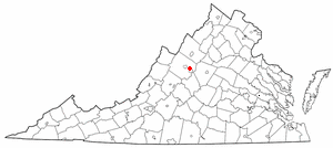
Waynesboro is an independent city in the Commonwealth of Virginia. It is a principal city of the Staunton-Waynesboro Metropolitan Statistical Area. Waynesboro is located in the Shenandoah Valley and is surrounded by Augusta County. As of the 2020 census, the population was 22,196.

<span class="mw-page-title-main">Shenandoah County, Virginia</span> County in Virginia, United States

Shenandoah County is a county located in the Commonwealth of Virginia. As of the 2020 United States Census, the population was 44,186. Its county seat is Woodstock. It is part of the Shenandoah Valley region of Virginia.

<span class="mw-page-title-main">Rockingham County, Virginia</span> County in Virginia, United States

Rockingham County is a county located in the U.S. state of Virginia. As of the 2020 census, the population was 83,757. Its county seat is the independent city of Harrisonburg.

<span class="mw-page-title-main">Rockbridge County, Virginia</span> County in Virginia, United States

Rockbridge County is a county in the Shenandoah Valley on the western edge of the Commonwealth of Virginia. As of the 2020 census, the population was 22,650. Its county seat is the city of Lexington. Rockbridge County completely surrounds the independent cities of Buena Vista and Lexington. The Bureau of Economic Analysis combines the independent cities of Buena Vista and Lexington with Rockbridge County for statistical purposes.

<span class="mw-page-title-main">Page County, Virginia</span> County in Virginia, United States

Page County is located in the Commonwealth of Virginia. As of the 2020 census, the population was 23,709. Its county seat is Luray. Page County was formed in 1831 from Shenandoah and Rockingham counties and was named for John Page, Governor of Virginia from 1802 to 1805.

<span class="mw-page-title-main">Craig County, Virginia</span> County in Virginia, United States

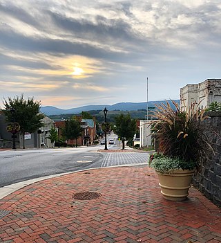
Craig County is a county located in the Commonwealth of Virginia. As of the 2020 census, the population was 4,892. Its county seat is New Castle.

<span class="mw-page-title-main">Buckingham County, Virginia</span> County in Virginia, United States

Buckingham County is a rural United States county located in the Commonwealth of Virginia, and containing the geographic center of the state. Buckingham County is part of the Piedmont region of Virginia, and the county seat is Buckingham.

<span class="mw-page-title-main">Botetourt County, Virginia</span> County in Virginia, United States

Botetourt County is a US county that lies in the Roanoke Region of Virginia. Located in the mountainous portion of the state, the county is bordered by two major ranges, the Blue Ridge Mountains and the Appalachian Mountains.

<span class="mw-page-title-main">Bedford County, Virginia</span> County in Virginia, United States

Bedford County is a United States county located in the Piedmont region of the Commonwealth of Virginia. Its county seat is the town of Bedford, which was an independent city from 1968 until rejoining the county in 2013.

<span class="mw-page-title-main">Bath County, Virginia</span> County in Virginia, United States

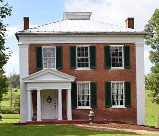
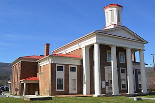
Bath County is a United States county on the central western border of the Commonwealth of Virginia, on the West Virginia state line. As of the 2020 census, the population was 4,209, the second-least populous county in Virginia. Bath's county seat is Warm Springs.

<span class="mw-page-title-main">Albemarle County, Virginia</span> County in Virginia, United States

Albemarle County is a county located in the Piedmont region of the Commonwealth of Virginia. Its county seat is Charlottesville, which is an independent city and enclave entirely surrounded by the county. Albemarle County is part of the Charlottesville Metropolitan Statistical Area. As of the 2020 census, the population was 112,395.

<span class="mw-page-title-main">Crimora, Virginia</span> CDP in Virginia, United States

Crimora is a census-designated place (CDP) in Augusta County, Virginia, United States. The population was 2,209 at the 2010 census, a 23% increase from the 1,796 reported in 2000. It is part of the Staunton–Waynesboro Micropolitan Statistical Area.

<span class="mw-page-title-main">Fishersville, Virginia</span> CDP in Virginia, United States

Fishersville is a census-designated place (CDP) in Augusta County, Virginia, United States. The population was 7,462 at the 2010 census, an increase of nearly fifty percent from the 4,998 reported in 2000. It is part of the Staunton–Waynesboro Micropolitan Statistical Area.

<span class="mw-page-title-main">Greenville, Virginia</span> CDP in Virginia, United States

Greenville is a census-designated place (CDP) in Augusta County, Virginia, United States. The population was 887 at the 2020 census. It is part of the Staunton–Waynesboro Micropolitan Statistical Area.

<span class="mw-page-title-main">Verona, Virginia</span> CDP in Virginia, United States

Verona is a census-designated place (CDP) in Augusta County, Virginia, United States. The population was 4,239 at the 2010 census. It is part of the Staunton–Waynesboro Micropolitan Statistical Area.

<span class="mw-page-title-main">Weyers Cave, Virginia</span> CDP in Virginia, United States

Weyers Cave is a census-designated place (CDP) in Augusta County, Virginia, United States. The population was 2,700 at the 2020 census. It is part of the Staunton–Waynesboro Micropolitan Statistical Area.

<span class="mw-page-title-main">Grottoes, Virginia</span> Town in Virginia, United States

Grottoes is an incorporated town in Augusta and Rockingham counties in the U.S. state of Virginia. The population was 2,668 at the 2010 census.

<span class="mw-page-title-main">Staunton, Virginia</span> Independent city in Virginia, United States

Staunton is an independent city in the U.S. Commonwealth of Virginia. As of the 2020 census, the population was 25,750. In Virginia, independent cities are separate jurisdictions from the counties that surround them, so the government offices of Augusta County are in Verona, which is contiguous to Staunton. Staunton is a principal city of the Staunton-Waynesboro Metropolitan Statistical Area, which had a 2010 population of 118,502. Staunton is known for being the birthplace of Woodrow Wilson, the 28th U.S. president, and as the home of Mary Baldwin University, historically a women's college. The city is also home to Stuart Hall, a private co-ed preparatory school, as well as the Virginia School for the Deaf and Blind. It was the first city in the United States with a fully defined city manager system.

<span class="mw-page-title-main">Virginia's 6th congressional district</span> U.S. House district for Virginia

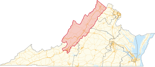
Virginia's sixth congressional district is a United States congressional district in the Commonwealth of Virginia. It covers much of the west-central portion of the state, including Roanoke and most of the Shenandoah Valley. The current representative is Ben Cline (R), who has held the seat since the 2019 retirement of incumbent Republican Bob Goodlatte.

<span class="mw-page-title-main">Staunton–Waynesboro metropolitan area</span>

The Staunton–Waynesboro Metropolitan Statistical Area is a United States Metropolitan Statistical Area (MSA) in Virginia, as defined by the Office of Management and Budget (OMB). As of the 2020 census, the MSA had a population of 125,433.

References

  1. "Find a County". National Association of Counties. Archived from the original on May 31, 2011. Retrieved June 7, 2011.
  2. "Augusta County, Virginia". United States Census Bureau . Retrieved January 30, 2022.
  3. Salmon, edited by Emily J.; Campbell, Edward D.C. Jr. (1994). The Hornbook of Virginia History: A Ready Reference Guide to the Old Dominion's People, Places, and Past (4th ed.). Richmond: Library of Virginia. ISBN   0884901777.{{cite book}}: |first1= has generic name (help)
  4. 1 2 "History". Augusta County, Virginia. Archived from the original on November 27, 2019. Retrieved November 27, 2019.
  5. "US Gazetteer files: 2010, 2000, and 1990". United States Census Bureau. February 12, 2011. Retrieved April 23, 2011.
  6. "Census of Population and Housing from 1790-2000". US Census Bureau . Retrieved January 24, 2022.
  7. "Historical Census Browser". University of Virginia Library. Retrieved December 31, 2013.
  8. "Population of Counties by Decennial Census: 1900 to 1990". United States Census Bureau. Retrieved December 31, 2013.
  9. "Census 2000 PHC-T-4. Ranking Tables for Counties: 1990 and 2000" (PDF). United States Census Bureau. Archived (PDF) from the original on October 9, 2022. Retrieved December 31, 2013.
  10. 1 2 "P2 Hispanic or Latino, and Not Hispanic or Latino by Race – 2010: DEC Redistricting Data (PL 94-171) - Augusta County, Virginia". United States Census Bureau .
  11. 1 2 "P2 Hispanic or Latino, and Not Hispanic or Latino by Race – 2020: DEC Redistricting Data (PL 94-171) - Augusta County, Virginia". United States Census Bureau .
  12. "U.S. Census website". United States Census Bureau . Retrieved May 14, 2011.
  13. "Incorporated Places and Minor Civil Divisions Datasets: Subcounty Resident Population Estimates: April 1, 2010 to July 1, 2014". United States Census Bureau. Archived from the original on May 23, 2015. Retrieved February 14, 2016.
  14. Leip, David. "Dave Leip's Atlas of U.S. Presidential Elections". uselectionatlas.org. Retrieved December 8, 2020
  15. Augusta County Sheriff's Office - History
  16. Augusta County Sheriff's Office - Accreditation
  17. Hagi, Randi B. (November 8, 2021). "Local BLM group sues Augusta County sheriff". WMRA and WEMC. Retrieved October 20, 2022.
  18. "Judge throws out majority of Augusta County Sheriff's Office charges from 2021 protests". The News Leader. September 5, 2022. Retrieved October 20, 2022.
  19. Urenko, Cayley; Brooks, Kayla. "Supervisors vote to close body camera donation account for Augusta County Sheriff's Office". NBC 29. Retrieved October 20, 2022.
  20. "Augusta County, Virginia Comprehensive Annual Financial Report, for the Year ended June 30, 2009" (PDF). Retrieved November 4, 2011.[ permanent dead link ]
  21. 1 2 3 4 5 6 7 8 9 10 11 12 13 14 15 16 17 Who Was Who in America, Historical Volume, 1607-1896. Chicago: Marquis Who's Who. 1963.
  22. John Meriwether McAllister and Mrs. Lura May Boulton Tandy (1906). Genealogies of the Lewis and kindred families. Columbia, Missouri: E. W. Stephens Publishing Company.
  23. 'The History of Dubuque County,' Western Historical, 1880, Biographical Sketch of Thomas McKnight, pg. 975

Further reading

38°12′N79°7′W / 38.200°N 79.117°W / 38.200; -79.117