
Augusta is the capital of the U.S. state of Maine and the county seat of and most populous city in Kennebec County. Augusta is included in the Lewiston-Auburn, Maine metropolitan New England city and town area. The city's population was 18,899 at the 2020 census, making it the 12th most populous city in Maine, and 3rd least populous state capital in the United States after Montpelier, Vermont, and Pierre, South Dakota.

Pendleton County is a county located in the U.S. state of West Virginia. As of the 2020 census, the population was 6,143, making it the second-least populous county in West Virginia. Its county seat is Franklin. The county was created by the Virginia General Assembly in 1788 from parts of Augusta, Hardy, and Rockingham counties and was named for Edmund Pendleton (1721–1803), a distinguished Virginia statesman and jurist. Pendleton County was strongly pro-Confederate during the American Civil War; however, there were pockets of Unionists who supported the state government in Wheeling.

Hampshire County is a county in the U.S. state of West Virginia. As of the 2020 census, the population was 23,093. Its county seat is Romney, West Virginia's oldest town (1762). The county was created by the Virginia General Assembly in 1754, from parts of Frederick and Augusta Counties (Virginia) and is the state's oldest county. The county lies in both West Virginia's Eastern Panhandle and Potomac Highlands regions.

Rockingham County is a county located in the U.S. state of Virginia. As of the 2020 census, the population was 83,757. Its county seat is the independent city of Harrisonburg.

Bath County is a United States county on the central western border of the Commonwealth of Virginia, on the West Virginia state line. As of the 2020 census, the population was 4,209, the second-least populous county in Virginia. Bath's county seat is Warm Springs.
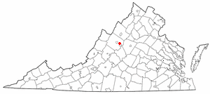
Augusta County is a county in the Shenandoah Valley on the western edge of the Commonwealth of Virginia in the United States. The second-largest county of Virginia by total area, it completely surrounds the independent cities of Staunton and Waynesboro. Its county seat is Staunton, but most of the administrative services have offices in neighboring Verona.
Perry County is a county located in the U.S. state of Mississippi. As of the 2020 census, the population was 11,511. The county seat is New Augusta. The county is named after the War of 1812 naval hero, Oliver Hazard Perry.

Craigsville is a town in Augusta County, Virginia, United States. The population was 923 at the 2010 census. It is part of the Staunton–Waynesboro Micropolitan Statistical Area.
Fishersville is a census-designated place (CDP) in Augusta County, Virginia, United States. The population was 7,462 at the 2010 census, an increase of nearly fifty percent from the 4,998 reported in 2000. It is part of the Staunton–Waynesboro Micropolitan Statistical Area.

Stuarts Draft is a census-designated place (CDP) in Augusta County, Virginia, United States. It is part of the Staunton–Waynesboro Micropolitan Statistical Area and adjacent to the South River. Its population was 12,142 as of the 2020 census.

Verona is a census-designated place (CDP) in Augusta County, Virginia, United States. The population was 4,239 at the 2010 census. It is part of the Staunton–Waynesboro Micropolitan Statistical Area.
Falling Spring is a town in Greenbrier County, West Virginia, United States. It is also known as Renick from the name of its post office. The population was 171 at the 2020 census.

Grottoes is an incorporated town in Augusta and Rockingham counties in the U.S. state of Virginia. The population was 2,668 at the 2010 census.
Augusta is an unincorporated community in central Hampshire County, West Virginia, United States. It is located along the Northwestern Turnpike at the northern terminus of Augusta-Ford Hill Road between Shanks and Pleasant Dale, east of Romney. According to the 2000 census, the Augusta community has a population of 4,728.

Virginia's third congressional district is a United States congressional district in the Commonwealth of Virginia, serving the independent cities of Norfolk, Newport News, Hampton, Portsmouth, and part of the independent city of Chesapeake. The district is represented by Democrat Bobby Scott. VA-03 is majority-minority and has a plurality Black electorate, and is heavily Democratic.
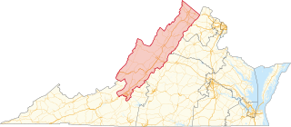
Virginia's sixth congressional district is a United States congressional district in the Commonwealth of Virginia. It covers much of the west-central portion of the state, including Roanoke and most of the Shenandoah Valley. The current representative is Ben Cline (R), who has held the seat since the 2019 retirement of incumbent Republican Bob Goodlatte.

Churchville is a census-designated place (CDP) in the western part of Augusta County, Virginia, United States. The population as of the 2010 Census was 194. Churchville is part of the Staunton–Waynesboro Micropolitan Statistical Area.

Spring Hill is an unincorporated community in Augusta County, Virginia, United States.

The Staunton–Waynesboro Metropolitan Statistical Area is a United States Metropolitan Statistical Area (MSA) in Virginia, as defined by the Office of Management and Budget (OMB). As of the 2020 census, the MSA had a population of 125,433.

